Jared Smith founded @chswx on Twitter in 2008 as an experiment in disseminating weather data through social media. In the ensuing decade-and-a-half, @chswx has provided live coverage of tropical cyclones, tornadoes, severe weather, and even a couple bouts of winter weather to the good people of Charleston, SC.
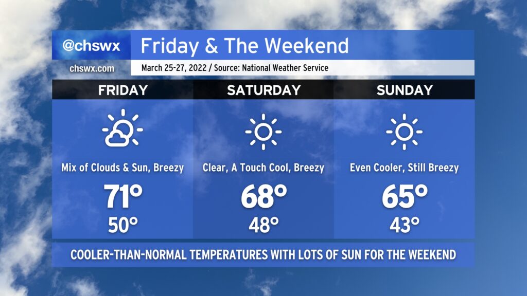
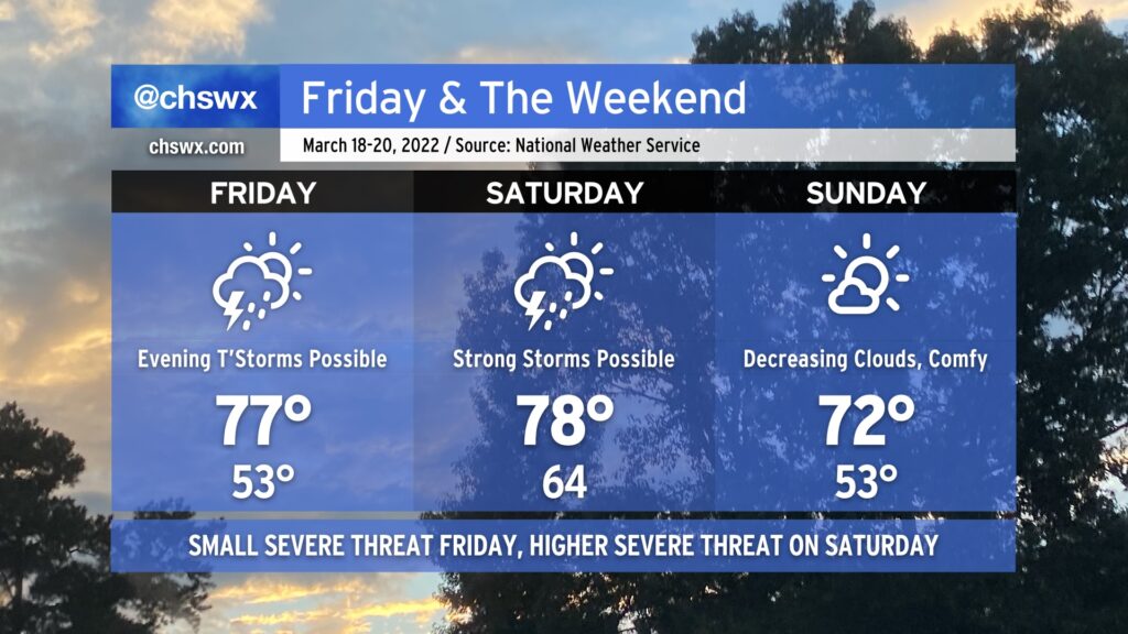
After some much needed rain Wednesday into Thursday, cooler and drier air builds back into the area for Friday and the weekend thanks to a series of cold fronts. Highs will top out in the low 70s on Friday with a mix of clouds and sun ahead of Saturday’s front, which will scour those clouds out and kick temperatures down a couple degrees, capping highs in the upper 60s to around 70°. Another reinforcing cold front gets through late Saturday into early Sunday, knocking temperatures back even further into the low 40s to start before only rebounding to the mid-60s in the afternoon despite full sunshine.
Through all of these frontal passages, expect gusty winds. Winds could gust upwards of 25-30 MPH on Friday, with gusts reaching or even exceeding 30 MPH on Saturday. Breezy conditions should also persist on Sunday as well. Keep this in mind if you have any outdoor activities planned, particularly those that involve tents or inflatables.
Fair weather persists into the upcoming work week, too, as a warming trend commences with highs approaching 80° by next Wednesday.
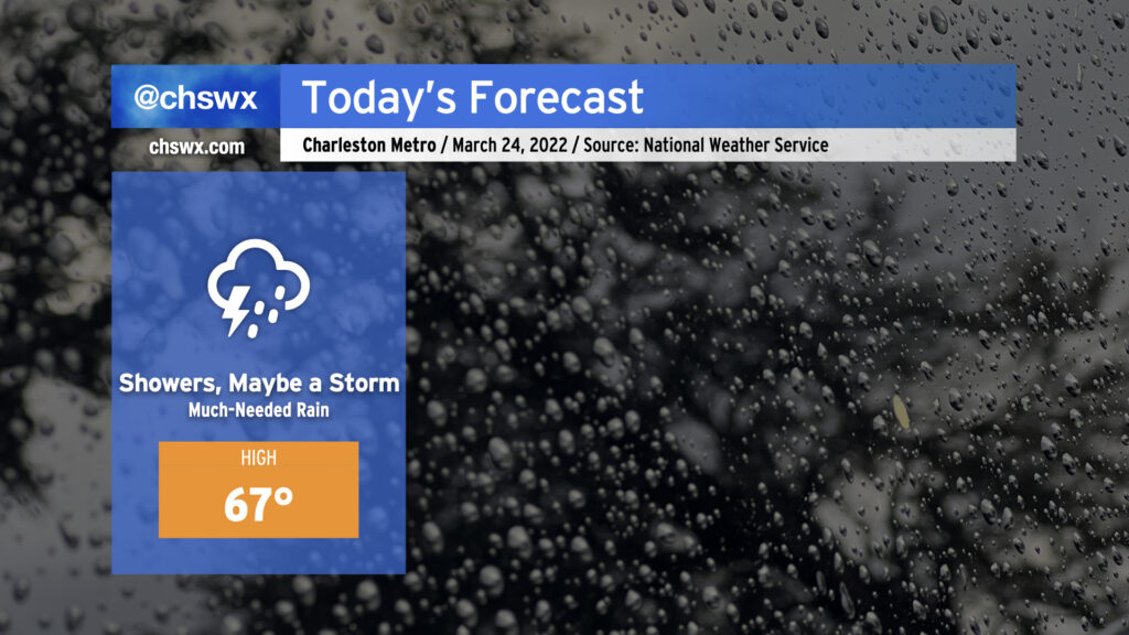
Much-needed rain will continue to fall for a good bit of today across the Charleston metro as a cold front slides eastward across the state. Said front will help to keep temperatures pretty steady-state throughout the day — we aren’t too far off from the NWS forecast high as of this writing (9am Thursday). No severe weather is expected, but we may yet hear a few more rumbles of thunder.
Rain will gradually taper off as we get into tonight, but showers may linger into early Friday morning. If you’ve got outdoor plans this evening, you may yet want to execute the indoor plan just to keep folks dry.
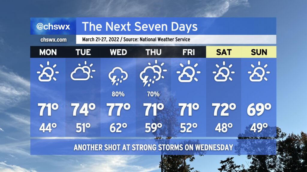
An unsettled period begins on Wednesday as our next storm system approaches the area. This storm system could aid in producing a few strong to severe thunderstorms in the afternoon.
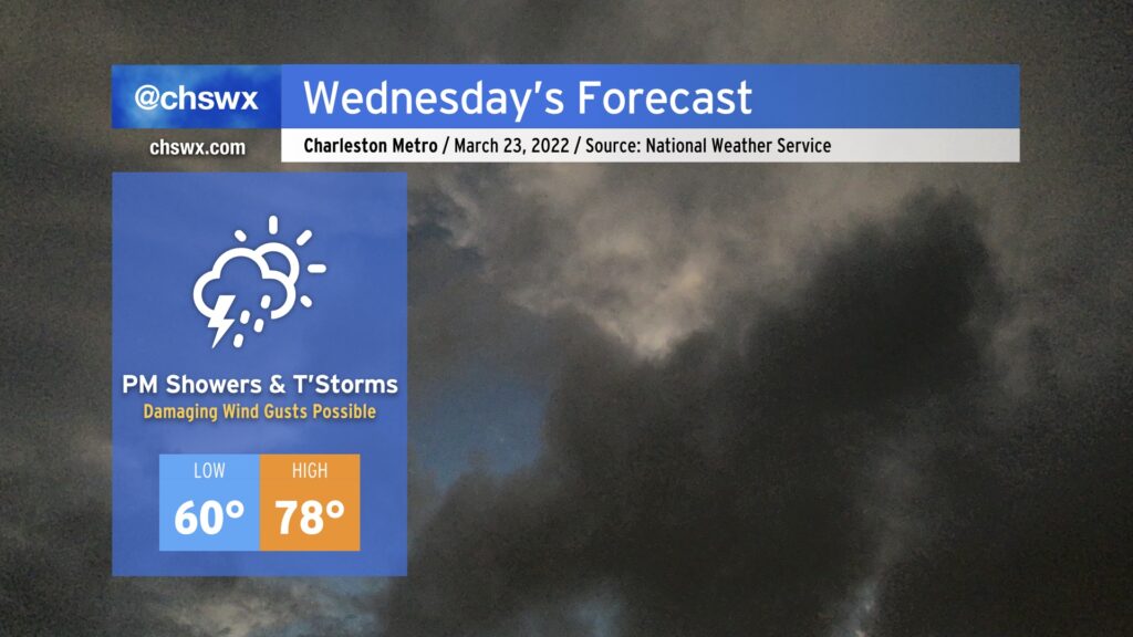
A warm front will cross the area overnight, and as a result, Wednesday starts out with lows bottoming out just around 60° around the area. The Gulf will be open for business with a plume of warm, moist air overspreading the Carolinas ahead of a cold front. This should keep a fair bit of cloud cover around, but despite this, temperatures could still approach 80° in the afternoon, particularly if we get some peeks of sun mixed in during the day.
The morning appears to be dry, but it isn’t out of the question to see some showers try to get going ahead of the main event. With that in mind, though, the vast majority of guidance members are keeping things dry until the afternoon. The best chance of showers and thunderstorms could arrive in the form of a squall line in the evening. Instability should be modest at best, but ample wind shear could be enough to produce a few damaging wind gusts if storms can stay organized. Hail and even a tornado can’t be ruled out, either. As usual for our neck of the woods, the available instability will modulate the severe threat. Most of you shouldn’t see any severe weather tomorrow, but in case it does threaten, you’ll want to know about it: have reliable ways to hear watches and warnings, and be ready to move to a safe place if a warning is issued for your location.
Rain should continue well into Thursday as the front and moisture hangs around before finally moving away early Friday. Regardless of any severe weather, the rain will be quite nice to wash away some pollen and help chip away at the drought. The reward will be pretty sweet, too: a gorgeous Friday and the weekend, with fair weather continuing well into the following work week.
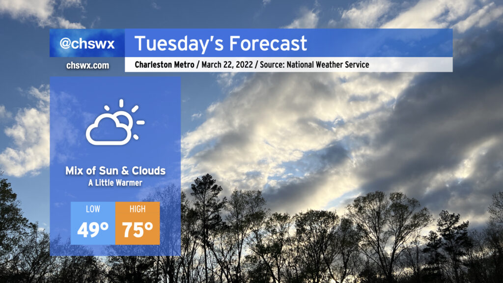
High pressure will continue to slip offshore overnight into Tuesday, allowing warmer and a little more humid air to keep working its way into the area. We stay rain-free on Tuesday, though, despite an increase in cloud cover. Highs top out in the mid-70s. Perhaps it won’t be the most picturesque day like we’ve had over the past couple days, but it will certainly be another decently nice day across the area.
Attention then turns to Wednesday, where there remains a risk for some severe storms that’s largely conditional on the timing of a cold front coming through the area. We’ll have the shear in place, but once again the question is instability and whether it will be available by the time forcing for ascent arrives. If the front gets closer earlier in the day, that could provide the necessary trigger for thunderstorms to develop and take advantage of that energy (though the amount of energy that would be available doesn’t look overly impressive). If it’s later in the day, though, we’ll see that instability begin to wane; as a result, the severe threat could be tempered somewhat. We should get some more clarity on the timing issues tomorrow; for now, prepare for a wet Wednesday with the potential for a few strong to severe thunderstorms. Hail, high winds, and a tornado are all on the table if in fact storms can get cranking, but as we know from recent days, that can be a big if. Stay tuned…
The week ahead will be bookended by really nice weather, though we’re going to need to get through another risk of showers and thunderstorms — yes, with a few possibly being severe — on Wednesday before we get through to the weekend.
For Monday, though, expect a slightly less windy carbon copy of Sunday. After starting in the mid-40s, highs will topping out in the low 70s under mostly sunny skies as cool and dry high pressure hangs on for one more day. We’ll see temperatures begin to head back up on Tuesday along with cloud cover as high pressure slips offshore in advance of our next storm system on Wednesday.
Wednesday will once again test our stretch of good luck with severe weather threats so far this spring. We’ll see a warm front lift across the area in the morning, putting us (at least briefly) in the warm sector of a strong storm system which is forecast to bring significant weather impacts to the Gulf Coast over the next two days. While in that warm sector, temperatures look to warm to the upper 70s despite decent cloud cover. Early calls from the models show decent instability and ample shear supportive of a slight severe weather threat. Given the close proximity of the front, I’d expect a more linear storm mode with damaging straight-line winds the primary concern, but there seems to be enough low-level shear to support a low-end tornado threat as well. Even outside of thunderstorms, winds look to be rather gusty courtesy of a strong low-level jet moving across the area. So, you’ll want to keep an ear out for forecast updates for the next couple days as the details are worked out.
Exact timing on the front’s passage will still need to be worked out, but overall, expect rain chances to trend downward as Thursday goes on. The front will leave behind a rather pleasant airmass with plenty of sun, low humidity, and high temperatures running near normal (low 70s) for Friday and the weekend. And so it goes with spring — some really nice weather mixed with the occasional nastygram.
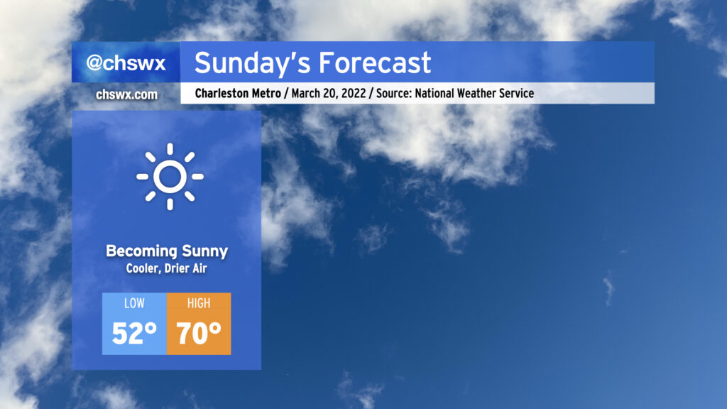
After a somewhat confounding weather day on Saturday, Sunday’s forecast is much higher confidence with high pressure building in behind a cold front that will swing through overnight. This’ll cool things off nicely, with highs topping out around 70° under sunny skies and low humidity to boot. It’ll be a nice day to get out for a walk or get some yard work done. This will kick off a stretch of a couple days of quiet weather before our next storm system arrives by mid-week, bringing us another shot at showers and thunderstorms for the second half of the work week. (We still can very much use the rain.)
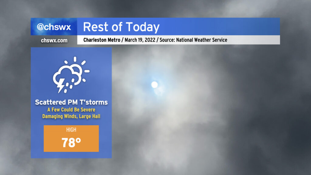
We’ve gotten off to a fairly benign start here in the Lowcountry, but that may change later today as a cold front approaches. Temperatures as of this writing are in the low 70s already with dewpoints in the low to mid-60s, pretty ripe for this time of year. Cloud cover has ticked up somewhat in part due to anvil blow-off from some thunderstorms already firing in southeast Georgia. Winds have also ticked up some, with a gust to 23 MPH recorded at the airport as of the 10am observation.
High temperatures across the Charleston metro should top out in the mid-to-upper 70s this afternoon before the cold front gets closer to the area. It’s this surface feature, currently moving across Georgia and into upstate South Carolina, which should provide the needed lift to allow for scattered thunderstorm development this afternoon. Wind shear and instability will not be lacking, and with some capping in place limiting more widespread development to start, storms could initially start off as supercells, increasing the severe weather threat. The strongest storms will be capable of damaging straight-line wind gusts and large hail. A tornado can’t be ruled out, particularly where storms interact with the seabreeze, which is forecast to be near the coast for much of the day. Given strong SW winds keeping the seabreeze pinned to the coast, it is unlikely that cooler waters will have a significant impact on storm strength.
Given the initially isolated nature of these thunderstorms and the timing of the cap breaking, it’s going to be very tough to pinpoint who exactly will see storms and when. General thinking, according to NWS, is that the greatest risk of thunderstorms will generally run between 3-9 PM. Trying to pin down too much more detail may be foolhardy without clairvoyance beyond what the science can provide.
Today’s advice is familiar: Stay close to reliable, redundant weather warning sources, one of which should not be your smartphone. NOAA Weather Radio and broadcast stations are two great ways to fulfill this recommendation. Not everyone will see severe weather today — perhaps, deity of your choice willing, none of us will! — but if it does threaten your location, you’ll want to be prepared to receive that warning and take action on it by having a safe space indoors, away from windows.
It’s turned out to be a pretty nice Thursday after a very foggy start. Temperatures topped out in the low-to-mid-70s across the area with plenty of sunshine emerging in the afternoon.
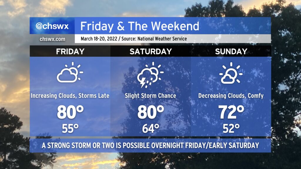
As we head into Friday and the weekend, another storm system will approach the area, bringing with it another round of showers and thunderstorms for some. Much of Friday should remain dry; temperatures ahead of the front will get into the upper 70s under partly cloudy skies. Thunderstorm chances increase with some upper-level energy moving in Friday evening. There’s an outside shot for a storm to briefly become strong or severe, with damaging winds the main concern, but that risk is conditional on whether any instability can develop.
Saturday could have a bit better severe weather threat as the cold front moves through. Wind shear will be favorable, and as long as Saturday doesn’t stay too overcast or showery, some decent instability should develop. This could lead to thunderstorms with damaging winds and large hail. A tornado isn’t off the table, either, with a little low-level shear indicated in the guidance suite. Temperatures look to head into the upper 70s once again before the front gets through later in the day.
Sunday looks great, though! A cooler and drier airmass will move into the area overnight, yielding lows in the low 50s and highs topping out in the low 70s under mostly sunny skies. It’ll be a little gusty as high pressure builds in behind the front, but there are no other weather concerns.
Quiet weather continues Monday into Tuesday before the next storm system and accompanying thunderstorm chances arrives on Wednesday.
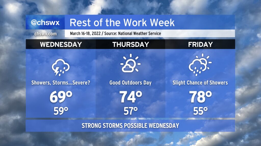
After some beneficial rain so far this Wednesday, we’ll see shower and storm chances taper off this evening as low pressure lifts northeast and away from the area. There is still the risk of a strong to severe thunderstorm for the next few hours (generally through sundown), so we’ll want to be keeping an eye on the radar for the next little bit.
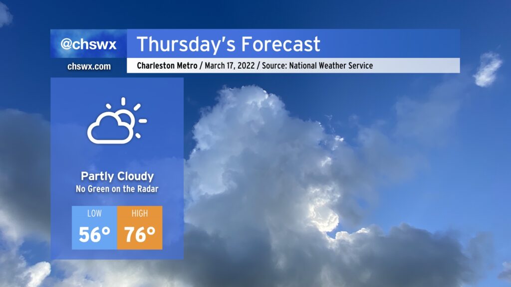
We take a break from rain on Thursday with partly cloudy to mostly sunny skies for St. Patrick’s Day. Temperatures will rise from the mid-50s in the morning to the mid-70s in the afternoon, and dewpoints in the 50s will make for a good middle ground between “too dry” and “too muggy.” Overall, not a bad St. Patrick’s Day, where the beer will hopefully be more green than the radar.
We’ll warm to near 80° on Friday with increasing cloud cover as another storm system moves through the Mid-South on its way to the Mid-Atlantic. Rain chances look to hold off until late, though. A few thunderstorms will be possible overnight Friday into early Saturday morning, and there once again is the potential for one or two of those to produce damaging wind gusts if conditions line up just right. We’ll keep an eye on how this evolves as nocturnal severe weather is, well, sub-optimal.
Slight shower and storm chances persist into Saturday, after which a cold front will come through and help deliver a rather beautiful Sunday with decreasing cloud cover and highs in the low 70s.
Up-and-down weather will finish out the work week with a nearly equal mix of nice and unsettled mixed in.
Wednesday will be the stormiest day of the set as surface low pressure and its parent upper low continue to rumble eastward into the area. Expect numerous showers and thunderstorms for a good bit of the day on Wednesday. One thing we’ll want to watch is if any instability can develop; if so, wind shear will be enough to support some strong to severe thunderstorms across the area. With rain in the area, highs should top out around 70° at best, which will put a governor on any severe threat that might materialize.
The storm system departs overnight Wednesday, and by Thursday, we clear out a bit, allowing for good sunshine and comfortable temperatures in the mid-70s in the afternoon. Should be a nice day to get out and about for lunch!
Friday starts out fairly nice as well — mid-50s for lows remain well above normal for this point in the year — before cloud cover increases ahead of another cold front. Showers could work into the area as early as the afternoon and evening hours, but the best risk of rain from this next storm system will be in the area for Saturday. Sunday, though, looks good with comfortable temperatures and ample sunshine.