Jared Smith founded @chswx on Twitter in 2008 as an experiment in disseminating weather data through social media. In the ensuing decade-and-a-half, @chswx has provided live coverage of tropical cyclones, tornadoes, severe weather, and even a couple bouts of winter weather to the good people of Charleston, SC.
After topping out in the upper 70s today, we’ll likely see temperatures breach 80° for the second time this year on Wednesday away from the cooler coastline as southerly flow around Atlantic high pressure keeps a very mid-spring-like feel to our weather in place. The temperature difference between the coast and just 10 miles inland could be pretty abrupt — highs may struggle to 70° at the beaches — thanks to the cooler nearby shelf waters and the potential for sea fog (more on that in a second). This pattern stays in place through Friday before a front swings through and cools us off quite significantly for the weekend.
One fly in the ointment will certainly be the potential for sea fog given such warm air over relatively chilly shelf waters. Short-term high-resolution guidance is in decent agreement that a sea fog bank could creep up the coast throughout the day Wednesday, lowering visibilities at the beaches and keeping temperatures some 10-15° cooler where fog hangs around. Southwesterly winds look to keep fog from penetrating too far inland, but that’s something we’ll keep an eye on as well for potential travel impacts. Sea fog will remain a bit of a wild card in the forecast through the end of the week, so stay tuned for tweaks.
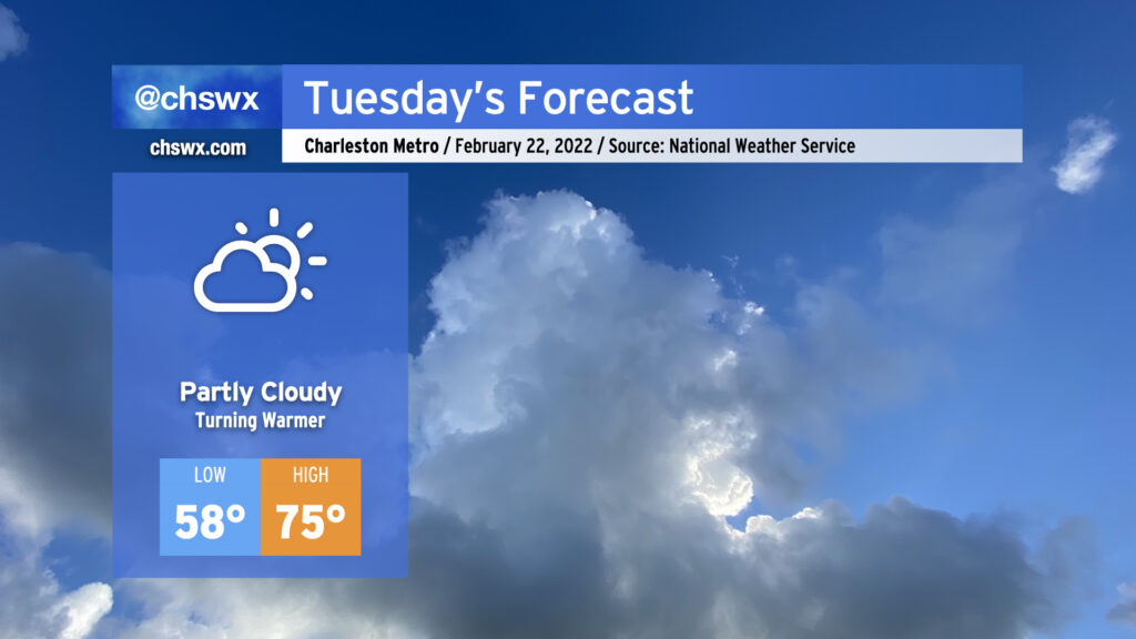
Atlantic high pressure remains the main weather feature as we head into Tuesday. This will keep partly cloudy skies in the forecast and allow temperatures to warm well into the 70s in the afternoon. Temperatures will really begin to ramp up starting Wednesday as a cold front stalls nearby, with highs in the 80s expected Wednesday-Friday before the front gets through and cools things right back off for the weekend.
After the possibility of a few showers tonight, we’ll maintain rain-free conditions through at least Friday if not Saturday before the pattern turns cooler and more unsettled as we start to get into next week.
After a really nice, seasonable weekend, temperatures will climb back into the 70s again on Monday, with 80s returning to challenge record highs by mid-week. A cold front looks to snap us back to more seasonable temperatures for the weekend.
Precipitation-wise, there will be a slight chance for some showers on Monday as a coastal trough develops and brings Atlantic moisture inland, but we otherwise look to stay dry through Friday, when the front brings a small chance of showers to the area.
With such warm temperatures and cooler shelf waters, sea fog is certainly a possibility over the next few days. This may impact visibility and temperatures at times, especially near the coast.
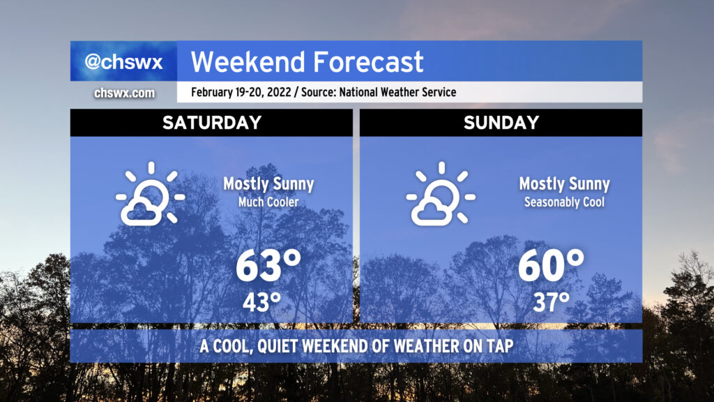
No weather concerns this weekend as high pressure is the main weather factor across the area. Temperatures will run much cooler than they did today — for crying out loud, we reached 80°! — but will feel much more seasonable overall for mid-February. There will be plenty of sunshine in the area, but the cooler airmass keeps highs in the low 60s on Saturday and perhaps struggling to reach 60° on Sunday. Overall, though, it’s solid sweater weather without the rain gear, and that isn’t bad for a big SEWE weekend in the Lowcountry.
We’ll be dealing with some showers on Friday as a cold front swings through the area. It’ll be one more day of unseasonably warm temperatures — the forecast low of 65° Friday morning is around the normal high for this part of the year — but those will come to an end with the frontal passage. The weekend looks great — mostly sunny skies with seasonable temperatures at or a touch below normal are in the forecast as high pressure builds across the area. Hope y’all get a chance to enjoy it a bit!
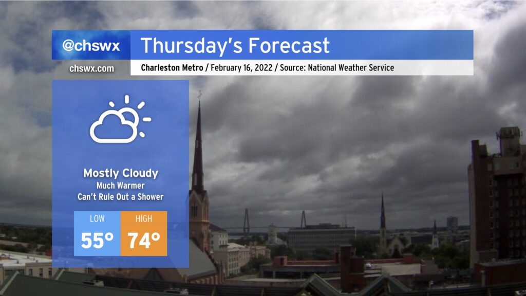
After an unexpectedly wet Wednesday — the product of strong convergence within a moist onshore flow — we’ll turn warmer for Thursday as winds go southerly ahead of the front. Temperatures in the mid-70s appear likely by the afternoon despite mostly cloudy skies. A shower or two can’t be totally ruled out, but the feature that brought us the rain today will not be in place tomorrow.
As the front gets closer later Thursday evening, shower chances will begin to head back up from the west, with the best chances of rain generally around and after midnight into Friday. A rumble of thunder can’t be totally ruled out, but severe weather is currently not expected.
The front gets through Friday with additional showers and maybe a thunderstorm. We then cool off for the weekend, with temperatures returning closer to normal values (low-mid 60s) for this time of year.
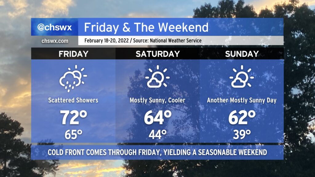
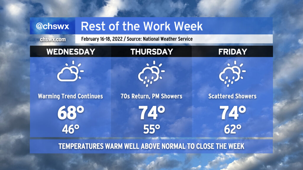
The rest of the work week will feature ever-warmer temperatures as a cold front approaches the area. Wednesday will be our last largely rain-free day, though, as shower chances enter the forecast for Thursday afternoon as the front gets closer. We could even hear some rumbles of thunder overnight Thursday into Friday morning. We’ll keep shower chances around for Friday, but peep those highs: mid-70s on Thursday and Friday. It’s been a while since we had a SEWE start out that warm, that’s for sure. Once the front is through sometime Friday evening, temperatures will calm down to more seasonable low-to-mid-60s highs for the weekend with a rain-free forecast expected.
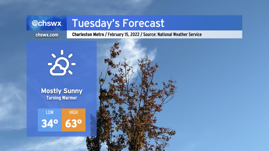
After a relatively chilly day to start the work week, we’ll begin to see temperatures rebound beginning Tuesday. Lows will once again scrape freezing in the morning, but we’ll be seeing highs top out in the low 60s in the afternoon with mostly sunny skies expected.
Temperatures continue to head up as the week goes on. Wednesday should scrape close to 70° in the afternoon, then we get warmer Thursday into Friday as a cold front approaches. Looks like our best rain chances for this week arrive beginning Thursday afternoon into Friday as the front gets through the area. More exact timings will become clearer over the next couple days, so stay tuned as those forecasts are fine-tuned. The good news is that the weekend’s weather looks seasonable and quiet, with temperatures within spitting distance of normal and rain-free conditions expected.
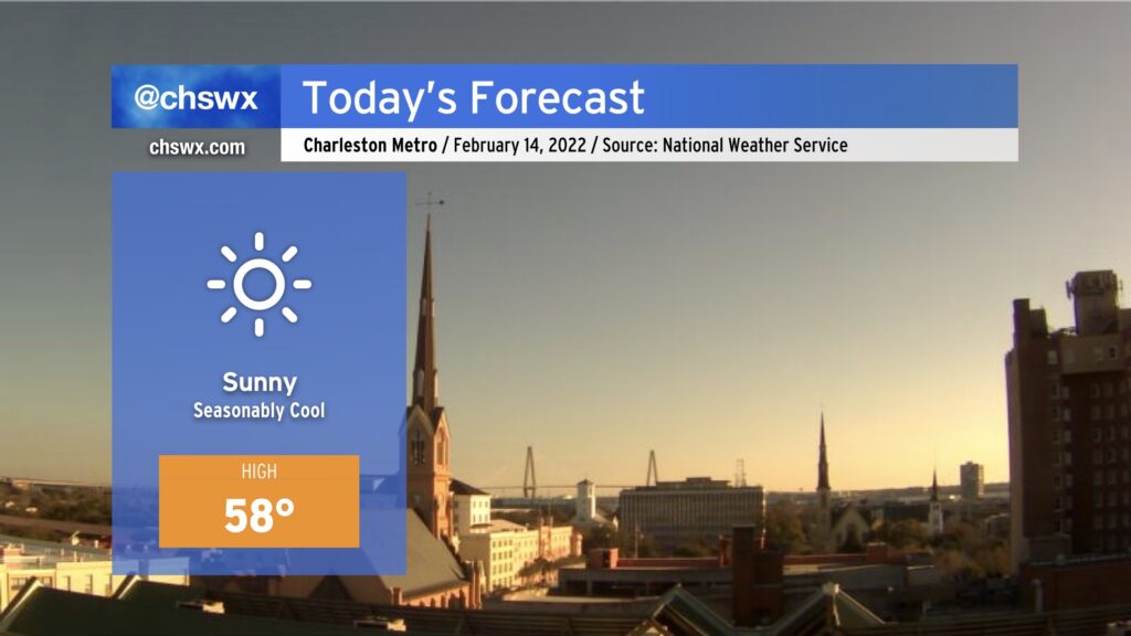
Temperatures are much cooler today in the wake of a cold front that moved by the area yesterday. We’ve started the day in the mid-30s at many spots, and temperatures don’t look to crack 60° this afternoon despite full sunshine. It’s a…erm…lovely day for the cool-weather fans in our midst. Looking for something warmer from Mother Nature? You don’t have to wait long — we’re back in the 70s by mid-week.
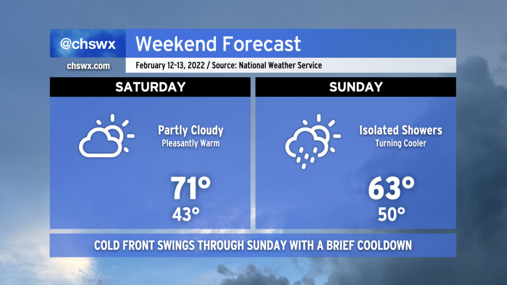
The weekend’s weather will turn on a cold front on Sunday. Saturday’s certainly the better day to get out and about with highs topping out in the low 70s despite increasing cloud cover. The cold front should get through the area sometime Sunday morning, accompanied by a wind shift to the northwest. Showers will be possible ahead of and around frontal passages, with slight shower chances indicated from early Sunday morning through the early afternoon hours. Sunday’s forecast high temperatures will be reached in the early afternoon before steadily falling for the rest of the day as cooler and drier air advects into the area. This airmass will make us all feel like we got the cold shoulder on Valentine’s Day, but temperatures will warm quickly thereafter, with a return to the 70s by late next week.