Jared Smith founded @chswx on Twitter in 2008 as an experiment in disseminating weather data through social media. In the ensuing decade-and-a-half, @chswx has provided live coverage of tropical cyclones, tornadoes, severe weather, and even a couple bouts of winter weather to the good people of Charleston, SC.
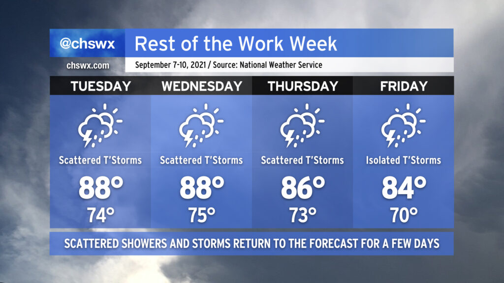
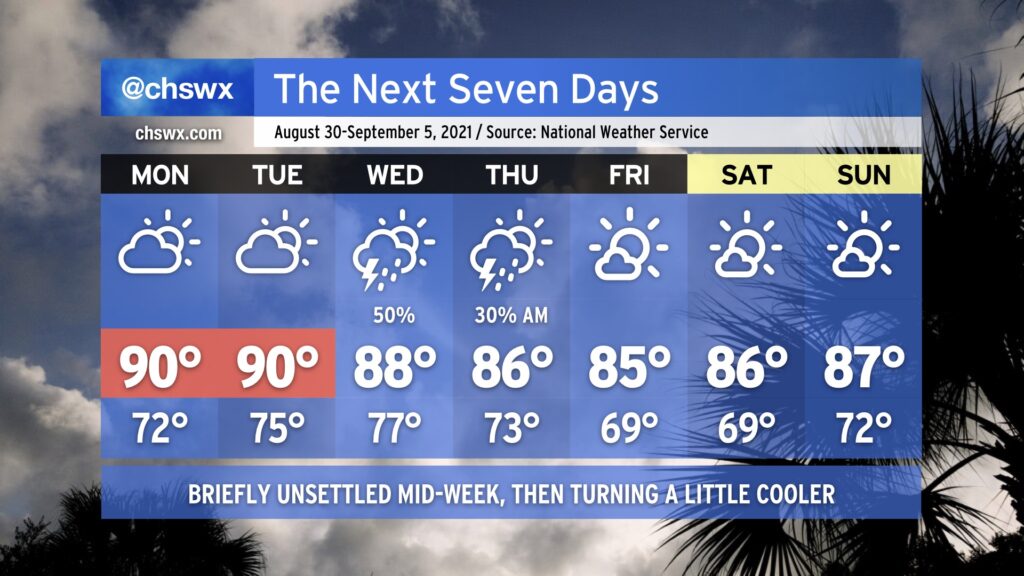
Warmth and humidity continue their return to the weather picture for the rest of this work week. We’ll see temperatures at or a little above normal as more tropical air works back into the area, increasing the risk for a few showers and thunderstorms each afternoon. A disturbance in the Gulf — which has a low (30%) chance of becoming a tropical cyclone over the next few days — could help to enhance rainfall across the area as it moves northeast across parts of Florida and Georgia later this week. By Friday, though, we begin to see a little cooler and drier high pressure move into the area from the north, helping to put the kibosh on more substantial rain chances heading into the weekend.
There will also be a risk for minor coastal flooding especially as we head later into the week as winds look to turn a little more onshore. We will be close each evening for the next few evenings, so keep an ear out for possible Coastal Flood Advisories from the National Weather Service.
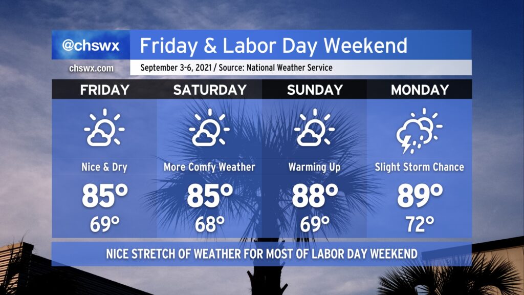
You can likely already feel it in the air — drier air has filtered into the area today, and it feels so much better outside already after a really humid August. A stretch of nice weather will ensue, with temperatures running a little below normal for Friday and Saturday. Lows in the mid-to-upper 60s will feel pretty good, for sure, and we’ll top out in the mid-80s Friday & Saturday. Temperatures moderate a bit higher on Sunday, with dewpoints creeping up as well. Humidity does make a comeback for Monday with a slight chance of afternoon thunderstorms, but all in all, the vast majority of us will stay dry this Labor Day weekend. Hope you can take advantage!
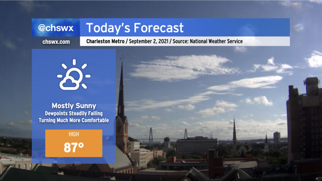
A cold front pushing south across the area is ushering in some lower dewpoints this morning, especially further north and west, making outdoors a little bit more comfortable today than we’ve seen in the recent past. We’ll stay warm with temperatures in the mid-to-upper 80s, but the gradual decrease in humidity throughout the day will make it more bearable. Another shot of drier air pushes in overnight, and tomorrow’s weather looks even better. Enjoy!
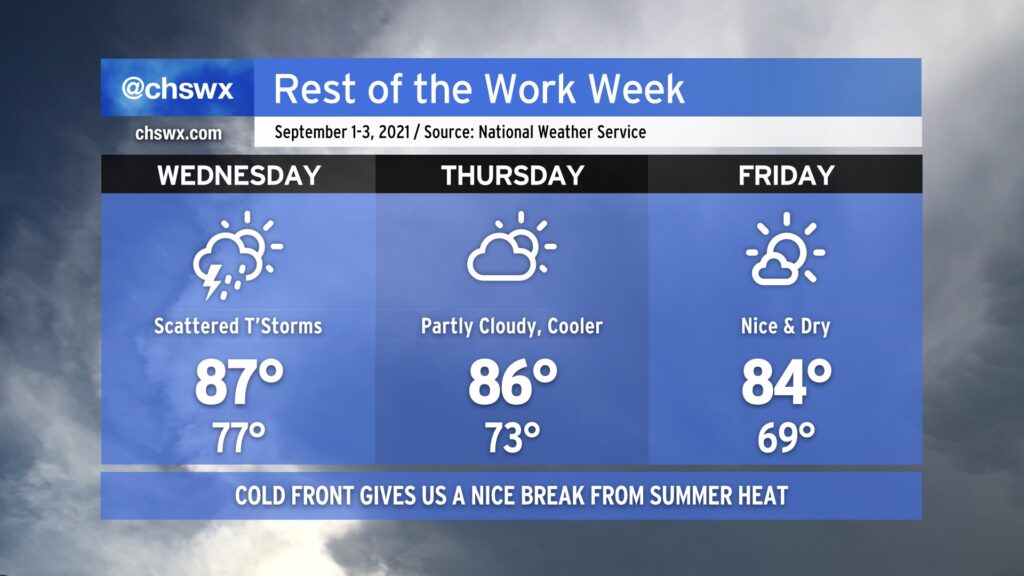
We start meteorological fall on a wet note. A cold front will drive southward across the area Wednesday into Wednesday night, and that will trigger scattered showers and thunderstorms as it pushes through and eventually stalls to our south. Behind the front, we will see some rather refreshing cooler and drier air begin to filter into the area. Dewpoints will drop starting Thursday, and by Friday, they should be in the mid-60s as opposed to the mid-70s. It will feel a lot more comfortable, that’s for sure, especially after a pretty muggy August.
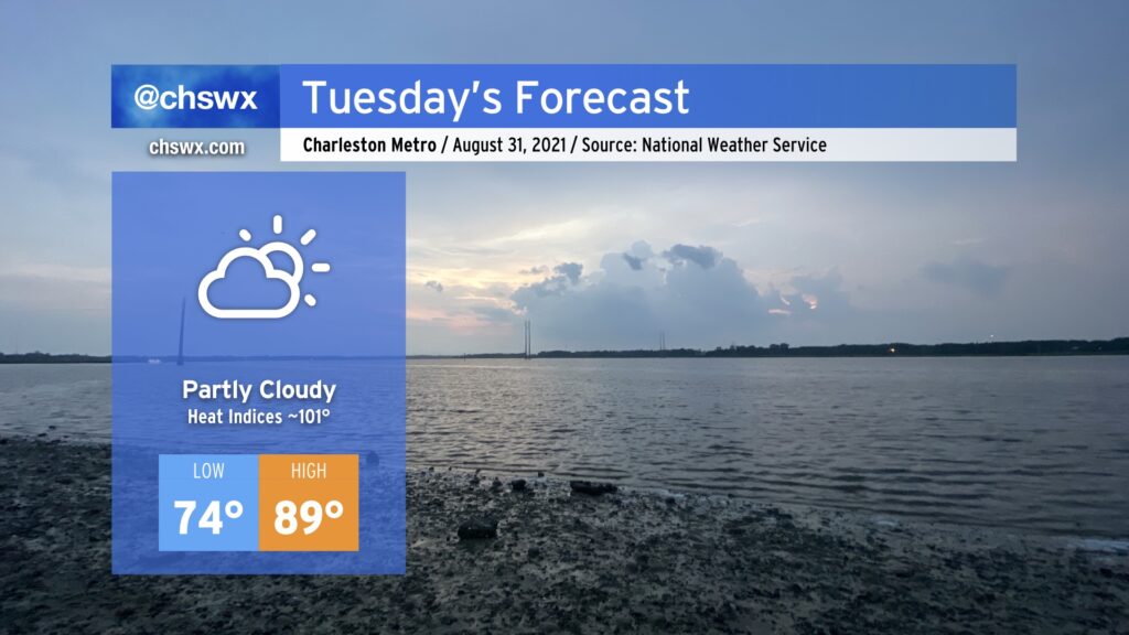
We will mark the end of August and meteorological summer with another day of near-normal heat and humidity under partly cloudy skies on Tuesday. Temperatures will once again approach 90° in the afternoon after starting in the muggy mid-70s. Heat indices will once again climb into the low 100s as humidity continues to persist.
After a cold front swings through Wednesday with showers and thunderstorms, though, drier air will punch in from the north and make it feel much more comfortable for Thursday into the weekend — a well-timed shot of nice weather as we head into the long Labor Day weekend.
On balance, the week ahead actually looks pretty good. Rain-free but warm conditions (highs ~90°) continue Monday and Tuesday as the ridge of high pressure remains in place across the region. By Wednesday, a cold front and a slug of moisture at least partially sourced from the remnants of Hurricane Ida push southward across the area, scattering showers and thunderstorms across the metro area. The front should clear the area by Thursday, yielding partly cloudy skies and somewhat cooler temperatures with less humidity as we head into the weekend — the first weekend of meteorological fall, which runs from September 1-November 30.
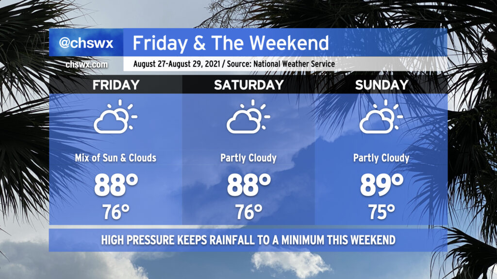
High pressure will continue its influence on our weather as we head into the final weekend of August. Temperatures look to remain in the upper 80s to around 90° each afternoon with warm starts in the mid-70s away from the coastline, where temperatures continue to struggle to get below 80° each morning. The aforementioned high pressure will act to keep shower and thunderstorm activity to a minimum through the weekend, certainly welcomed considering how soggy of an August we’ve had.
High pressure will also keep Tropical Storm Ida, forecast to become a hurricane as it approaches the central Gulf Coast this weekend, out of our hair. Unfortunately, it looks to be another direct strike on Louisiana, an area that is very tropical-cyclone weary after the numerous storms it dealt with last season. If you have friends or family there (as well as in coastal Mississippi and Alabama), please make sure they understand that time is of the essence to prepare as tropical storm-force winds could begin as soon as Saturday evening along the coast. Ida is forecast to make landfall sometime Sunday evening along the Louisiana coast. From there, its moisture may get caught up in a frontal system and help provide the juice for another round of wet weather here next week.
For now, though, enjoy a relatively quiet weekend of weather in our neck of the world.
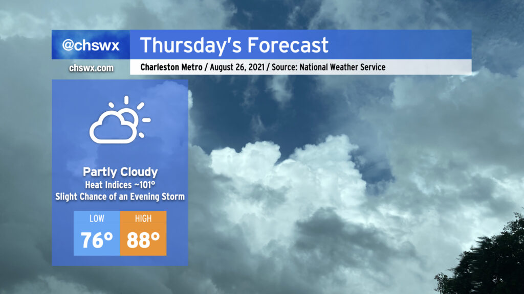
After scattered storms dotted the interior with downpours once again this afternoon, most of us get a rain-free Thursday as stacked high pressure and a lobe of (relatively) drier air filter into the area from the Atlantic. Temperatures look to head up to the upper 80s to around 90°, right around where we should be in late August. We’ll keep the relatively calm and quiet weather into Friday and the weekend as well, with upper 80s and just the standard slight chance of afternoon thunderstorms through Sunday.
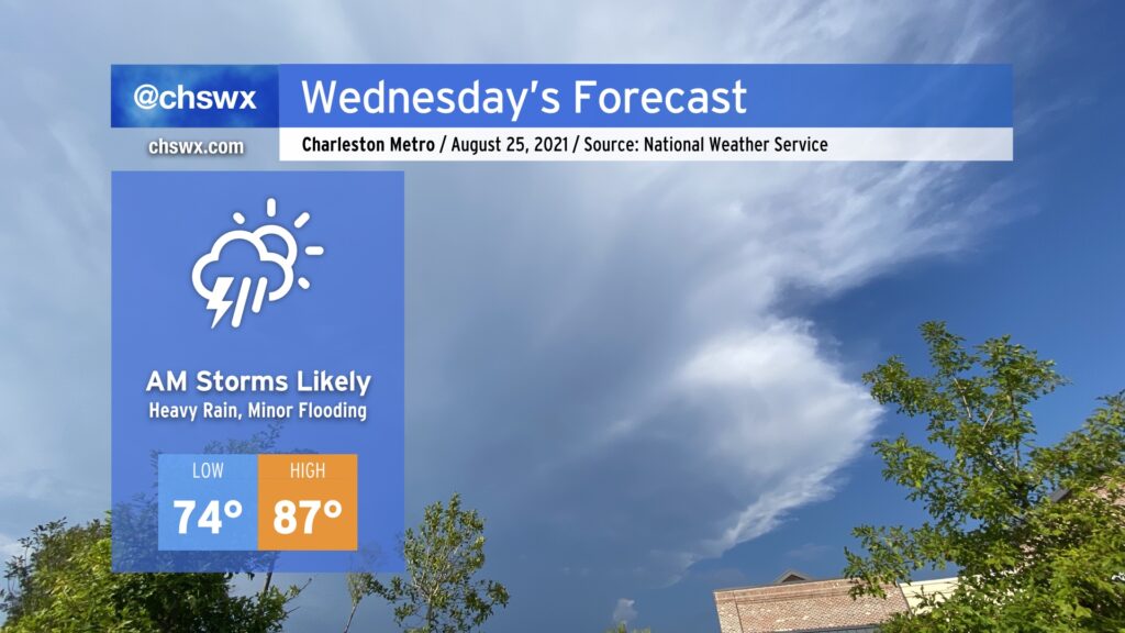
A tropical upper tropospheric trough — more commonly known as a TUTT low — will bring some unsettled weather into the area tonight into tomorrow morning as it moves westward across Florida and spins some energy and enhanced moisture our direction. The best risk for heavy rainfall in the morning will be along the coast. Rain could start to pick up quite early in the morning and be problematic through the commute. The good news is that much of it looks to fall around low tide, but minor flooding just cannot be ruled out given how soggy soils have become. By afternoon, the risk for showers and thunderstorms spreads inland.
Temperatures will top out in the upper 80s across the area in the afternoon. Mix that in with humidity, and you’ve once again got heat indices around 100° in the afternoon.
Rain chances turn a little more scattered Thursday into Friday and the weekend, but we’ll keep that summertime heat around with highs topping out in the upper 80s to around 90° each day.
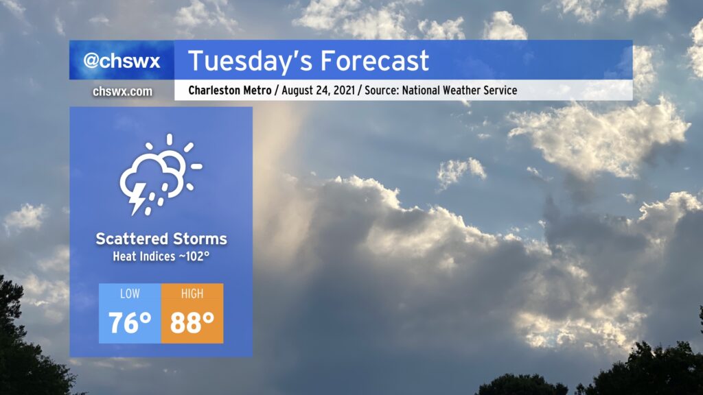
Persistence is the word when looking at Tuesday’s forecast: Warm, humid, with scattered thunderstorms firing along the seabreeze, primarily in the afternoon. (There is a chance a shower or two could scrape the coast in the morning, too.) Temperatures should generally top out in the upper 80s with heat indices in the low 100s thanks to plenty of late-August humidity.
Expect this pattern to stay with us for the rest of the week, with a little more coverage on Wednesday thanks to an upper-level tropical low (a Tropical Upper Tropospheric Trough, to be precise) helping to send a little more moisture and forcing our way. After that passes, coverage will ratchet back a few clicks as high pressure stays in control.