Jared Smith founded @chswx on Twitter in 2008 as an experiment in disseminating weather data through social media. In the ensuing decade-and-a-half, @chswx has provided live coverage of tropical cyclones, tornadoes, severe weather, and even a couple bouts of winter weather to the good people of Charleston, SC.
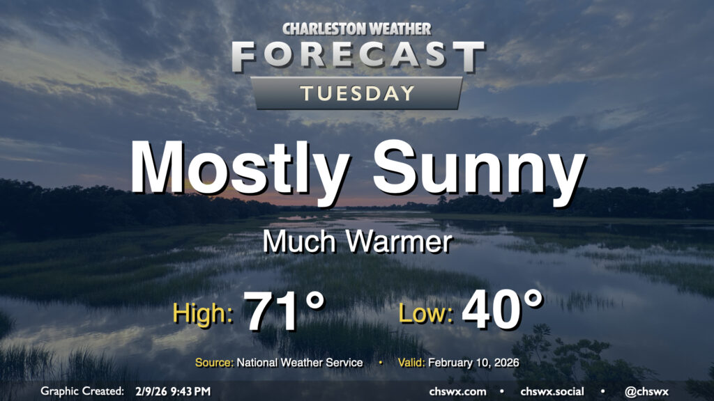
We had quite the temperature swing on Tuesday, with a low of 33° giving way to a high of 76° in the afternoon. A warm front that swung through around daybreak helped temperatures jump from 37° a little after 6am to 46° about 20 minutes later, according to the National Weather Service. From there, plenty of sunshine propelled us to the warmest day since January 10.
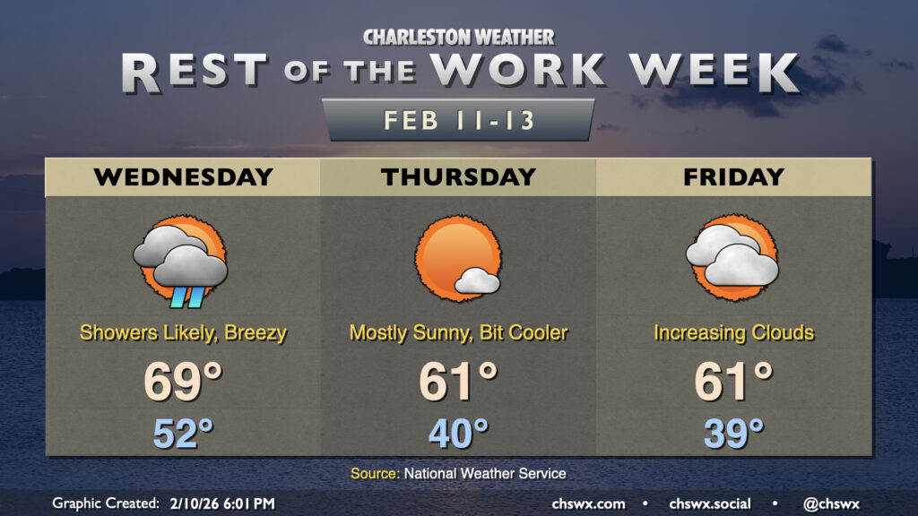
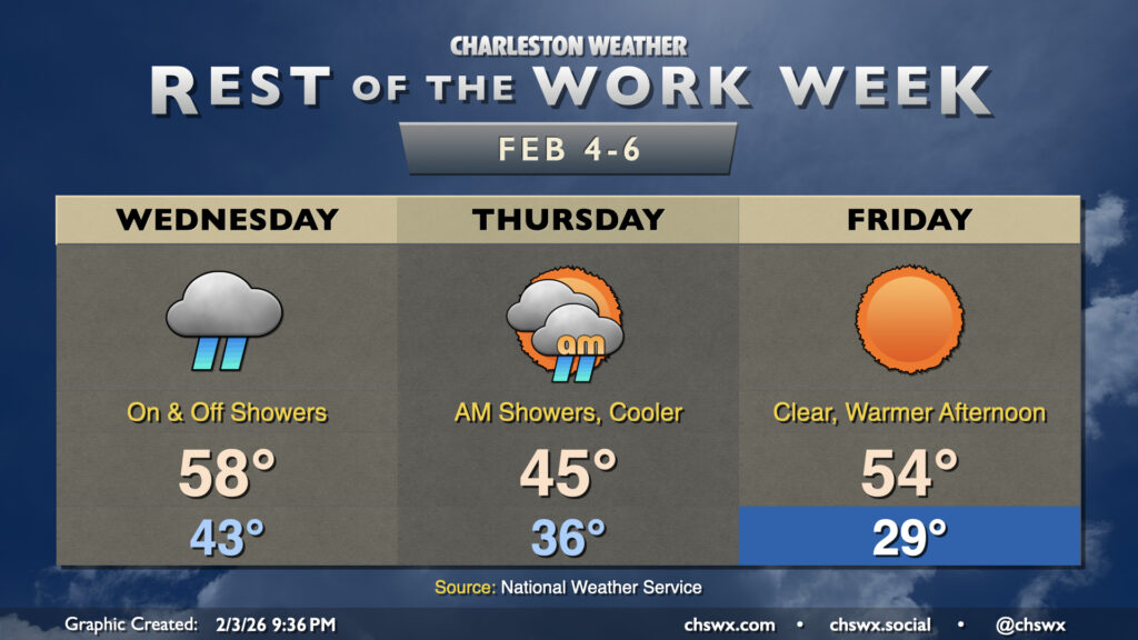
I hope you got to enjoy the brief spring preview, because the weather will turn more unsettled on Wednesday as a cold front approaches from the northwest. Temperatures will still run well above normal, with lows in the low 50s yielding to highs once again approaching 70° in the afternoon. Showers will begin to move into the area as early as daybreak, with off and on showers possible through the evening hours.
One could make the argument that Tuesday’s forecast might be the most pleasant in a few weeks as temperatures head well above normal as we end up on the north side of high pressure centered roughly around Tampa, FL. We’ll start the day around 40°, but west and southwest winds along with mostly sunny skies will help drive temperatures some 30° warmer during the day, with highs reaching the low 70s across much of the area (save for the immediate coast, where marine influences will keep temperatures capped to the upper 50s to around 60°). This should be our first 70° day since January 22, when the high reached 72°.
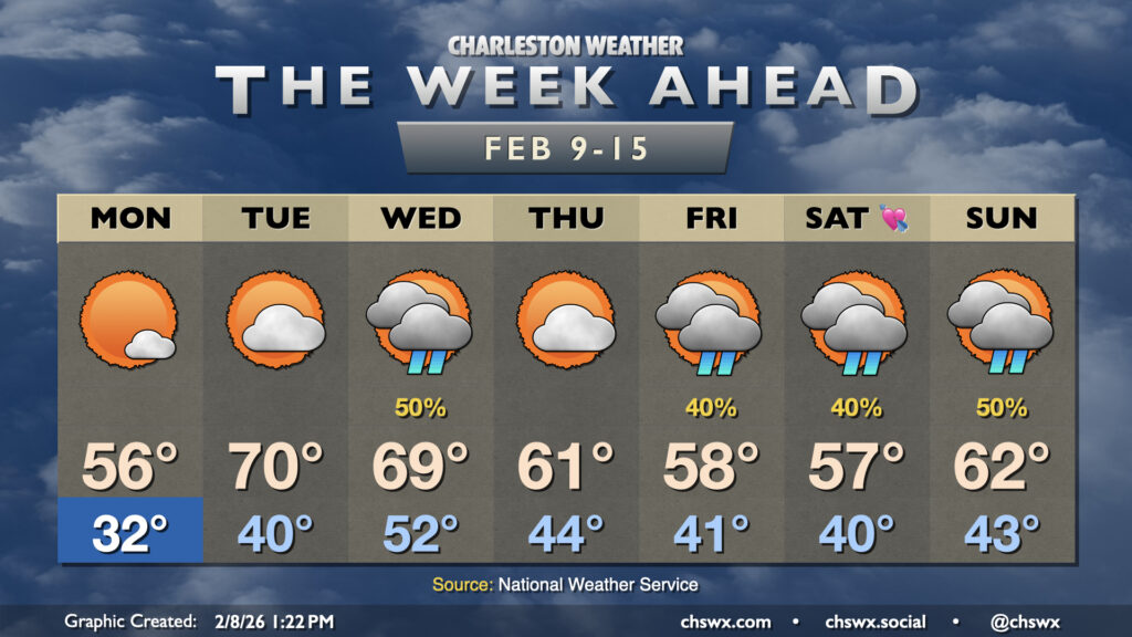
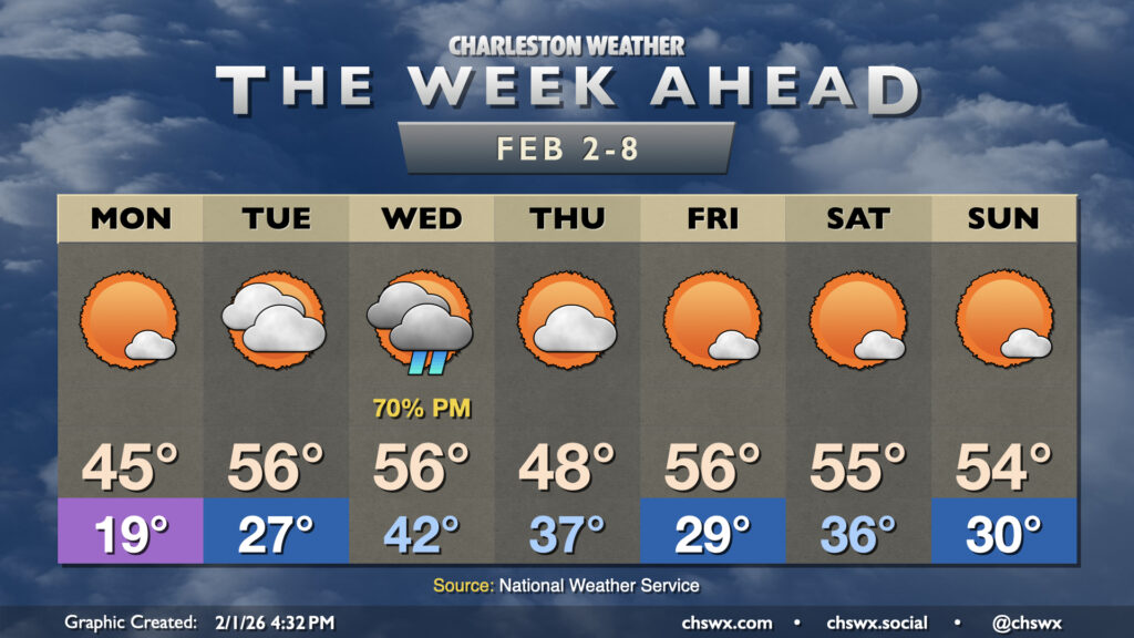
While we do have some rain chances in store this week, what we will be lacking (after Monday morning, anyway) is subfreezing cold. It’s been a very chilly start to February so far — in fact, this first week of February (Feb 1-7) ties 1951 for ninth coldest on record at the airport with an average temperature of 42.2°. We will thankfully break the cold snap this week as the upper-air pattern changes a bit, favoring a ridge trying to nudge in from the south that’ll keep the colder air bottled up to the north.
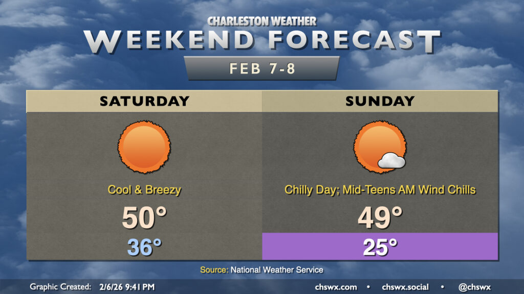
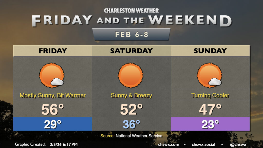
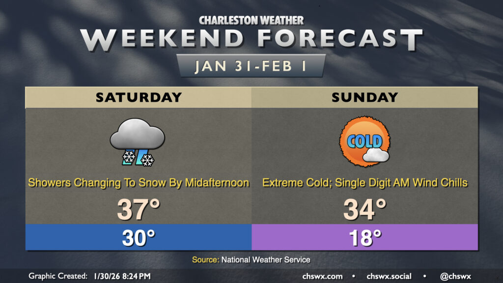
A chilly — but, thankfully, mostly sunny — weekend lies ahead as a reinforcing shot of cool air works its way in on Saturday. We’ll start Saturday in the mid-30s, but somewhat brisk northwesterly winds will drive the wind chill into the upper 20s to low 30s. Another push of cooler and drier air moves in during the day, and highs will only peak around 50° as a result with brisk winds continuing. Gusts to 25 MPH will be possible during the day, so keep that in mind for any outdoor activity you’ve got planned.
Sunshine returns as we head into the first full weekend of February, but we’ve got a few more days of below-normal temperatures before some relief arrives next week.
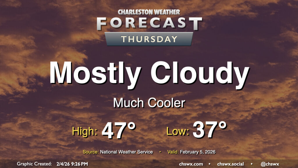
After some much-needed rain Wednesday, Thursday will be a much cooler day as a cold front moves by. Some showers may linger in the morning, but otherwise we can expect a mostly cloudy day with some peeks of sun from time to time. Expect temperatures to start in the mid-to-upper 30s, warming to just the mid-40s in the afternoon given the cloud cover and cooler air blowing in from the north.
With a high of 63°, Tuesday ended up being the warmest day since January 23rd, when the high was 68°. We’ll fall back off that peak a little bit for the rest of the work week, but 60s should return for next week. In the meantime, we’ve got another cold front to deal with on Wednesday, which will spread some showers into the area on and off, especially as we get into the afternoon and evening hours. Temperatures start in the low-to-mid-40s, and peak generally in the upper 50s to near 60° as showers overspread the area.
Our run of cooler than normal temperatures that closed January will continue for the first week of February, but a repeat of the past couple weekends of wintry intrigue, mercifully, is not expected.
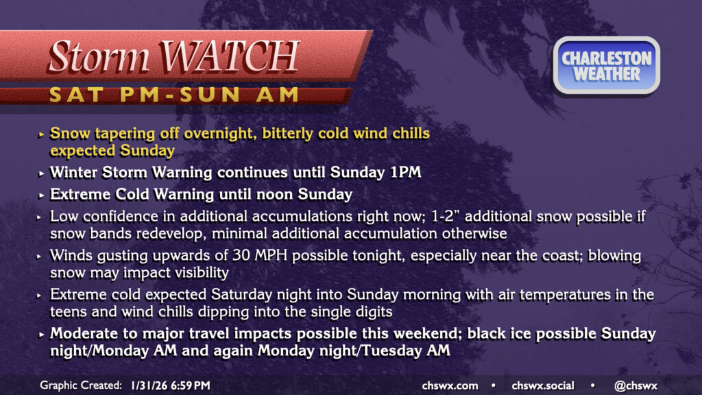
So far today, snow totals have come in a little under what was first expected for this phase of the event thanks to some dry air intrusion, and this trend right now looks to continue. The upper low which has been driving our snowfall will continue to lumber across the area tonight, and there remains the possibility for some additional bursts of snow to develop, though those opportunities will become increasingly rare as the night wears on. Latest guidance suggests that any remaining snowfall should scour out by 4-5 AM as drier air gets pulled in behind the departing coastal low. With gusts increasing to potentially 30 MPH, especially near and at the coast, there will be a risk for some of that light, fluffy snow to blow around and impede visibilities. Honestly, just best to stay in tonight if you can help it.
Well, it certainly appears as if the third time will be the charm for snow-lovers in the Lowcountry as a long-anticipated winter storm system impacts the area this weekend. A Winter Storm Warning goes into effect Saturday at 7AM and will run until Sunday at 1PM. Meanwhile, an Extreme Cold Warning will also go into effect Saturday at 7PM until noon Sunday for air temperatures in the mid-to-upper teens and wind chills dropping perhaps as low as 3° above zero in the morning — extraordinarily rare cold air for this part of the world.