Jared Smith founded @chswx on Twitter in 2008 as an experiment in disseminating weather data through social media. In the ensuing decade-and-a-half, @chswx has provided live coverage of tropical cyclones, tornadoes, severe weather, and even a couple bouts of winter weather to the good people of Charleston, SC.
First off, you’ve probably noticed that I’ve not been posting the past few days. I’ve had a fairly significant death in my family that has kept me away from work and weather, and that will keep the posting and podcast schedule fairly bare at times for the next couple weeks. I’ll have more to say on that soon and how you can help if you are interested.
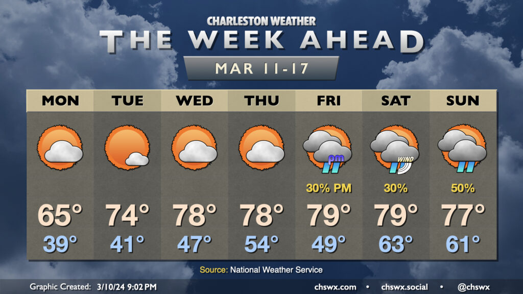
But first, we have a storm system arriving Friday that could pose a potentially significant flooding risk for downtown Charleston Friday night. Low pressure moving across the Gulf Coast states will drive perhaps a few rounds of heavy rain through the metro area starting Friday afternoon and well into the evening. This could coincide with high tide around 7:27pm to produce enough flooding to close roads downtown as well as in vulnerable locations in North Charleston and maybe even Summerville. 2″ or more of rain will be possible in many spots across the Tri-County. Be ready to curtail Friday night plans or find alternate routes in case widespread flooding develops.
Rain will continue into Saturday, though it’ll be more on and off. The heaviest stuff will have pivoted northward, but showers and maybe a thunderstorm should redevelop as a cold front pushes into the area during the afternoon. Severe weather is not expected, thankfully. Saturday’s the warmest day of the weekend with highs in the mid-70s, while post-front, we’ll see a solid 10° drop in high temperatures for Sunday. Clouds will be clearing, though, and we’ll be back in the 70s possibly as early as Monday.
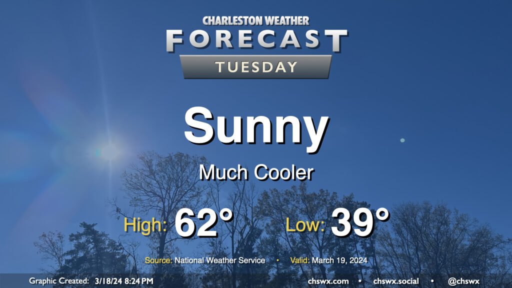
After the past couple weeks of warmth, Tuesday might come as a bit of a shock as lows dip into the upper 30s across a good bit of the metro to start the day as cool high pressure builds in throughout the day. Temperatures will only get into the low 60s, far below normal for mid-March (the normal high for March 19 is 71°). At least the sun will be out, and the March sun angle should make these cooler-than-normal temperatures feel pretty decent.
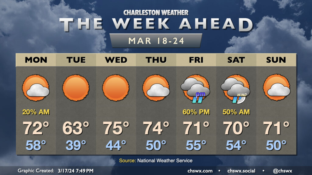
The week ahead starts off with the aftermath of a cold front, but that won’t be felt long as temperatures head right back toward, if not slightly above, mid-March norms as astronomical spring begins.
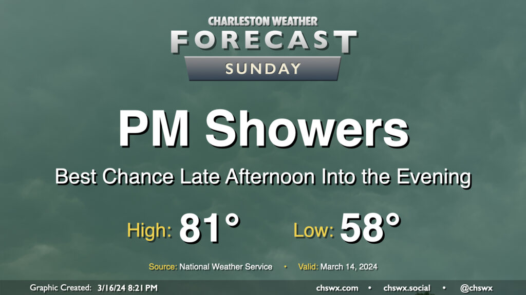
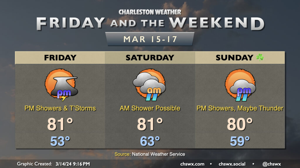
We have one more rather warm day ahead for St. Patrick’s Day, but changes are coming as a front moves into the area late Sunday. Showers will kick up along with this front, and while we’ll get much of Sunday in rain-free, the risk for showers increases later in the afternoon through the evening. Temperatures on Sunday start in the upper 50s, warming to the low 80s despite increasing cloud cover ahead of the unsettled weather.
The front will clear the area early Monday morning, leaving behind much cooler temperatures in its wake. Tuesday may be particularly chilly as highs only get to the low 60s, but we’ll rebound quickly for the second half of next week (though staying well south of the 80s).
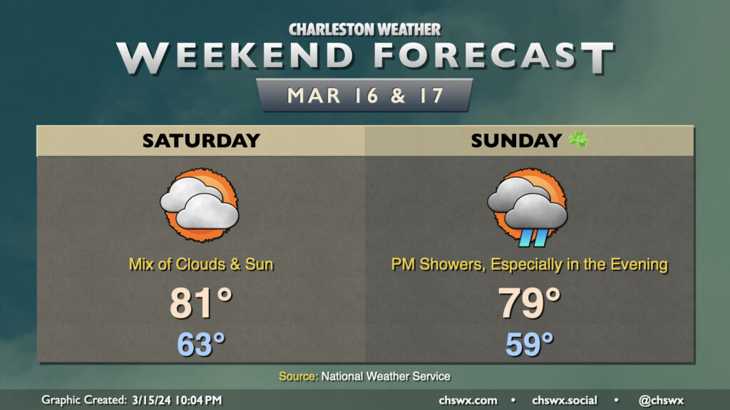
The weekend won’t be the sunniest, but it’ll still be on the warm side for a couple more days before a Sunday night cold front resets the needle a bit on this recent period of warmth.
We narrowly missed a record high on Friday; it was 86° at the airport, with the record of 87° set in 1967 getting a little nervous this afternoon. It won’t be quite as warm on Saturday with more in the way of cloud cover as a front lingers nearby, but we should still make it to the low 80s in the afternoon with a mix of clouds and sun. Showers look unlikely at this juncture as we sit in a lull between disturbances.
We’ll get St. Patrick’s morning in generally on the dry side (and a touch cooler too with lows in the upper 50s vs. Saturday’s low 60s), but showers should begin to increase by afternoon as the aforementioned cold front gets closer. By evening, expect a fair bit of shower activity to overspread the area. This should last into the overnight before tapering off by Monday morning, which will kick off a week of weather featuring temperatures much closer to mid-March norms.
High pressure will lose its grip on the area for Friday and the weekend, allowing some periods of unsettled weather to move in — but don’t fret as we’ll have plenty of rain-free time as well. It’ll stay quite warm, too, with 80s expected each afternoon.
We’ll at least get Friday morning in rain-free ahead of a disturbance that’ll push a cold front into the area Friday afternoon and evening. Showers and a few thunderstorms will be possible by mid-afternoon leading into the commute, but not before we warm back into the 80s once again. A strong storm may not be totally out of the question west of 17-A, but high-res guidance generally shows storms in a weakening trend as they push eastward toward much cooler shelf waters.
Shower and thunderstorm chances persist overnight Friday into Saturday morning before what looks like a break in the action for much of the day. Temperatures start quite mild — think low to mid-60s — and warm back to the low 80s in the afternoon under a mix of sun and clouds. Shower chances should hold off Saturday night and into a good bit of Sunday before returning later in the afternoon and into the evening as another front approaches the area. This front shakes us out of our run of 80s and back below normal for Monday and Tuesday of next week.
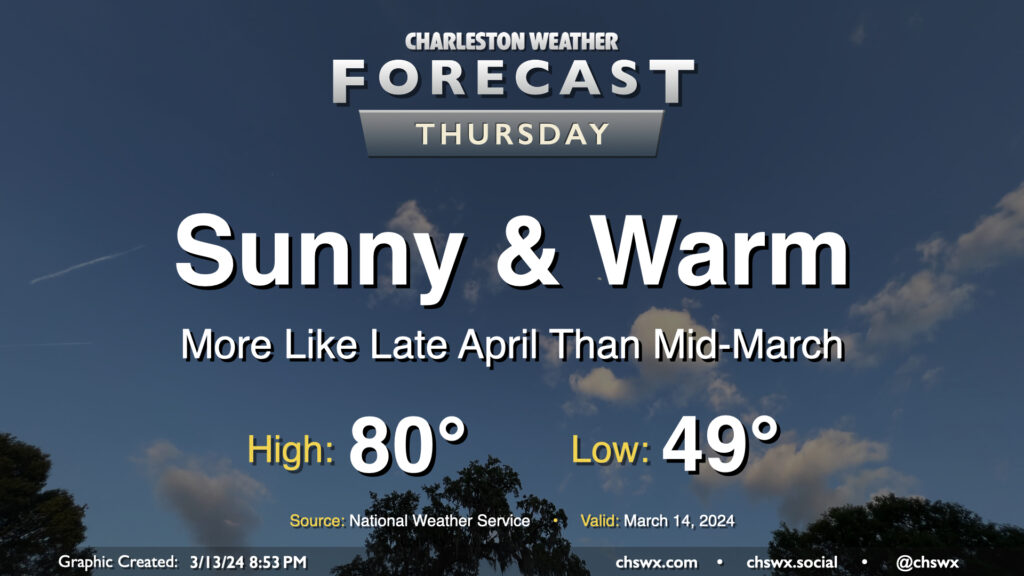
Thursday looks like an excellent weather day across the Lowcountry, something out of the late-April playbook but in mid-March. We’ll start the day around 50° once again, warming to the low 80s in the afternoon with maybe a few clouds amongst otherwise clear skies as ridging aloft strengthens briefly for the day. Expect winds generally in the 5-10 MPH range, picking up a little in the afternoon in the wake of a sea breeze. Enjoy!
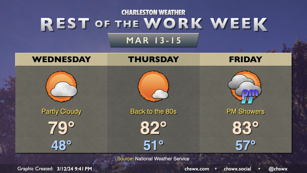
The rest of the work week will be much warmer than mid-March normals as high pressure ridges across the area at the surface and aloft. Temperatures on Wednesday will start in the upper 40s, warming to near 80° in the afternoon under partly cloudy skies as a weak disturbance ripples across the area, bringing only an uptick in cloud cover and little else given such a dry atmosphere at the surface. Thursday will see us solidly back in the 80s once again with just a cloud or two at times as high pressure will be strongest that day. We’ll start to see cloud cover come back up for Friday as high pressure gets shunted offshore by the next storm system, though it’ll still be a very warm day by mid-March standards as lows bottom out in the mid-50s with highs warming to the low 80s in the afternoon. We should get much of the day in rain-free, though a shower or two will be possible as we get into the late afternoon and evening hours.
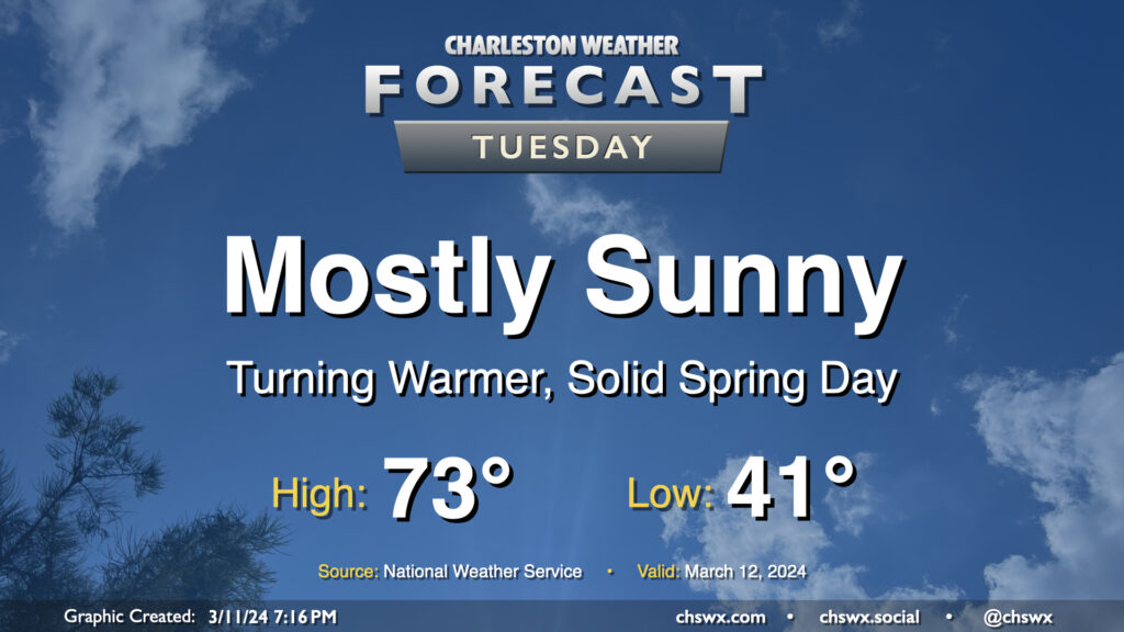
After one more somewhat chilly night — expect low 40s across much of the metro, with mid-to-upper 30s possible further inland — we start a warming trend that’ll get us into the 80s by the end of the week. Tuesday looks rather delightful: expect highs to top out in the low 70s away from the locally cooler coastline. Comfortably dry air will be in place with relative humidity bottoming out around 30% in the afternoon, and we’ll keep a solid amount of sunshine throughout the day. Winds will start to swing more southwesterly in the afternoon and kick up to around 5-10 MPH. Not bad!
The week ahead will be largely marked by high pressure before the next storm system starts to affect the area just in time for St. Patrick’s weekend. (Sorry.)