Jared Smith founded @chswx on Twitter in 2008 as an experiment in disseminating weather data through social media. In the ensuing decade-and-a-half, @chswx has provided live coverage of tropical cyclones, tornadoes, severe weather, and even a couple bouts of winter weather to the good people of Charleston, SC.
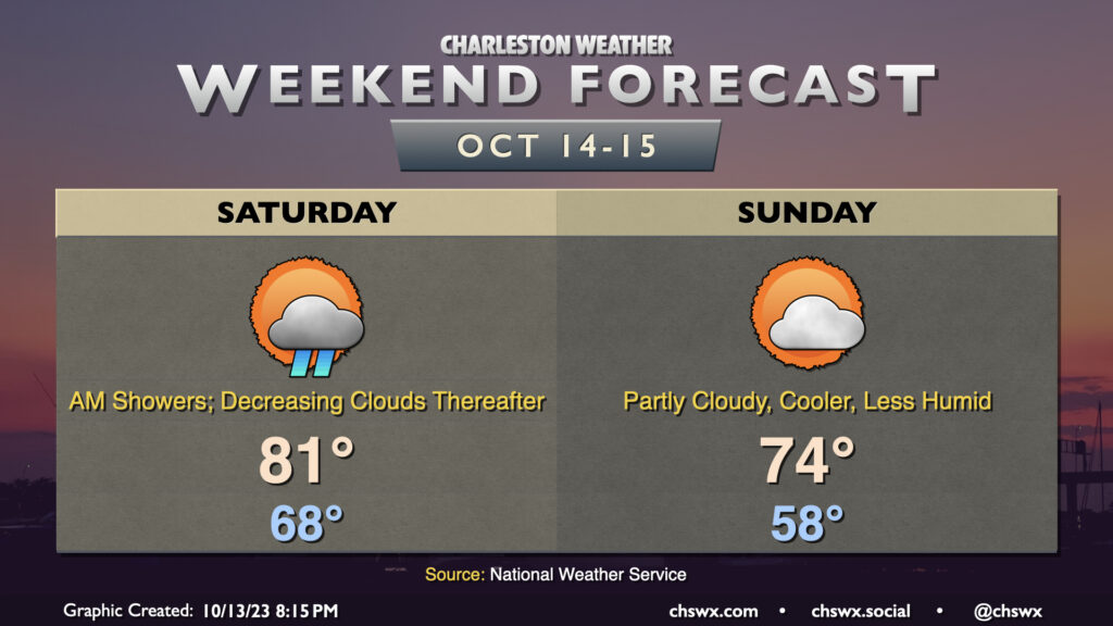
Low pressure will move northward across the area overnight Friday into Saturday morning, keeping shower chances (and maybe a rumble of thunder) in the forecast through roughly mid-morning. It’ll be a mild start, with lows bottoming out in the upper 60s to around 70°. Highs will warm into the low 80s, and it’ll generally be a muggy low 80s as dewpoints remain elevated in the upper 60s. Cloud cover will steadily decrease as the day goes on as low pressure continues to move further away.
A reinforcing cold front arrives overnight Saturday into early Sunday morning, and this will bring a much more noticeable change to the airmass. Dewpoints will drop into the 50s, and highs will only top out in the mid-70s in the afternoon. Cloud cover will increase as we get into the evening as a trough approaches the area, but we should still get plenty of sunshine in.
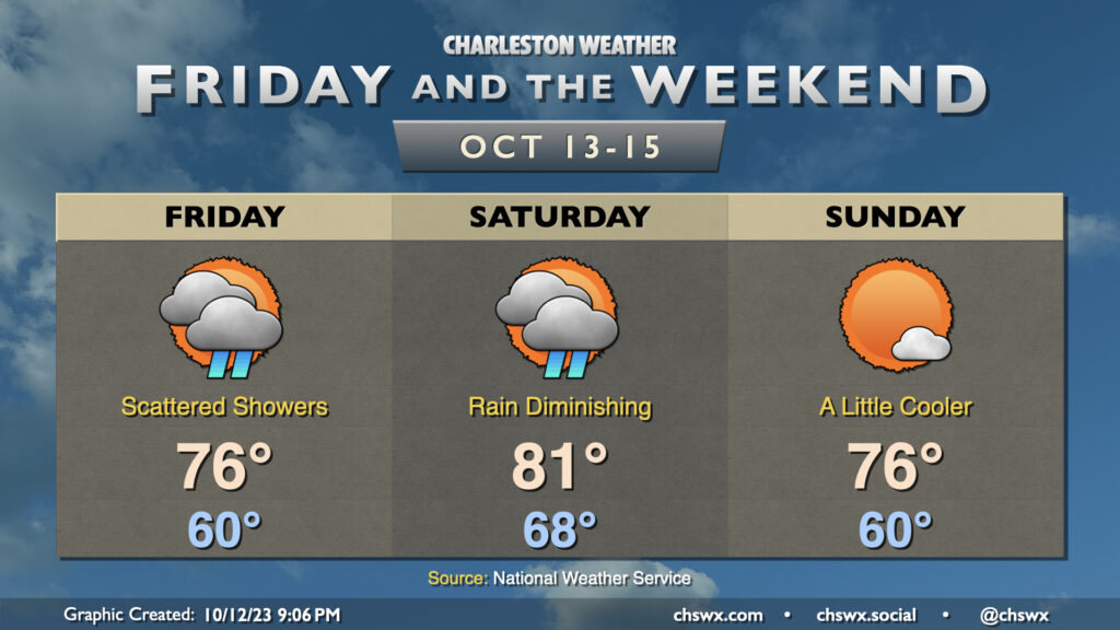
We stay unsettled — but turning warmer — on Friday as winds turn a little more onshore thanks to low pressure developing over northern Florida and southern Georgia. This will also help to keep showers in the area for a good bit of the day, so be ready with the rain gear just in case. Some breaks in the clouds may bring some sunshine, but cloudiness should remain the main feature. Expect highs to top out in the mid-70s.
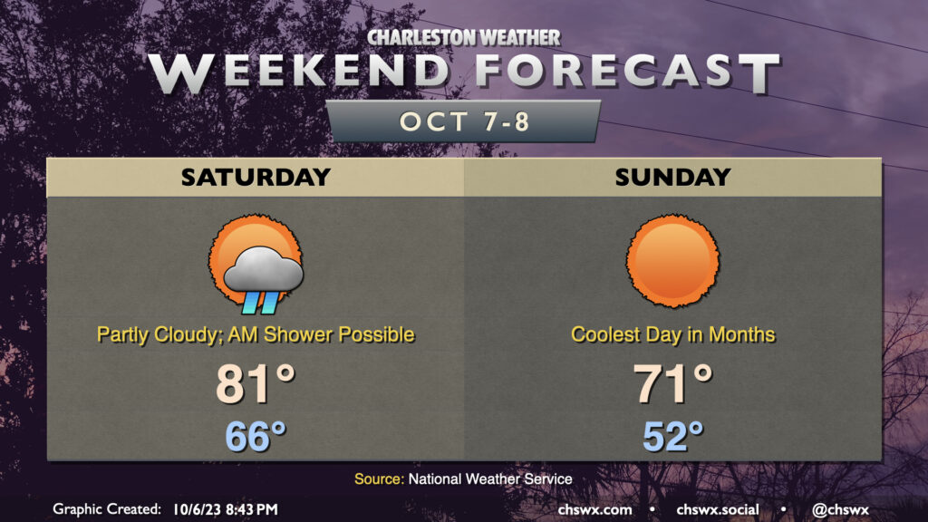
Showers will continue heading into Saturday as low pressure moves northward across the Lowcountry throughout the day. The low should clear the area by afternoon, and from there, we should start to see some slightly drier air work into the area. There should be at least some peeks of sun Saturday afternoon, so the day’s not a total loss, and we’ll get to the low 80s — as warm as we’ll be for the foreseeable future, it’s worth noting.
A stronger cold front comes through overnight and brings a much better shot of cooler and drier air to the area for Sunday. That’ll help to clear some of the cloud cover out a bit and help highs top out only in the mid-70s in the afternoon. Cooler and drier air will continue to work in overnight Sunday, and we’ll have a stretch of cooler-than-normal temperatures for much of next week.
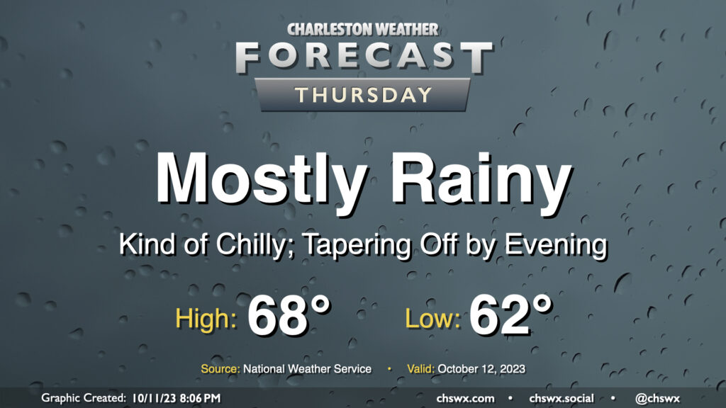
Showers overspreading the area Wednesday evening will continue for much of Thursday as low pressure moves offshore, allowing high pressure to wedge in behind it from the northeast. While rain chances taper heading into the evening, cloud cover should remain robust and temperatures on the cool side thanks to the wedge. We shouldn’t get out of the upper 60s, in fact. All in all, Thursday looks to be a good jacket or hoodie kind of day.
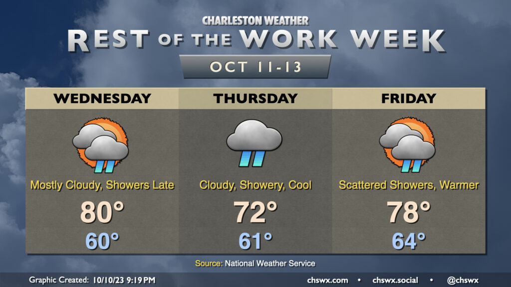
Increasing moisture will proliferate across the area during the day Wednesday as high pressure continues to give way to a disturbance that’ll move across the Gulf. Much of the day should be dry as it takes some time for the remaining dry air to scour out, but once that does, expect showers to begin at some point Wednesday evening, peaking overnight Wednesday into Thursday morning. Thursday’s going to be kind of a chilly and raw day as high pressure wedges in from the north, socking us in with cloud cover and occasional showers. Expect highs to top out in the low 70s at best. A warm front lifts north of the area later on Friday, and that’ll send temperatures back up a bit. We could see some rumbles of thunder alongside more scattered showers, so keep the rain gear handy.
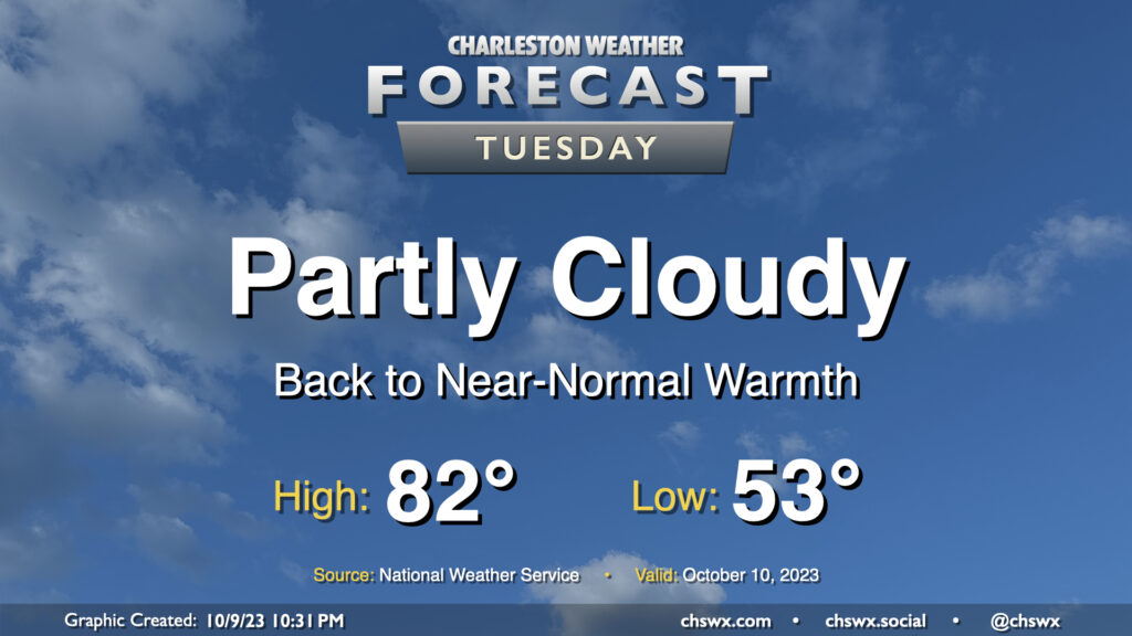
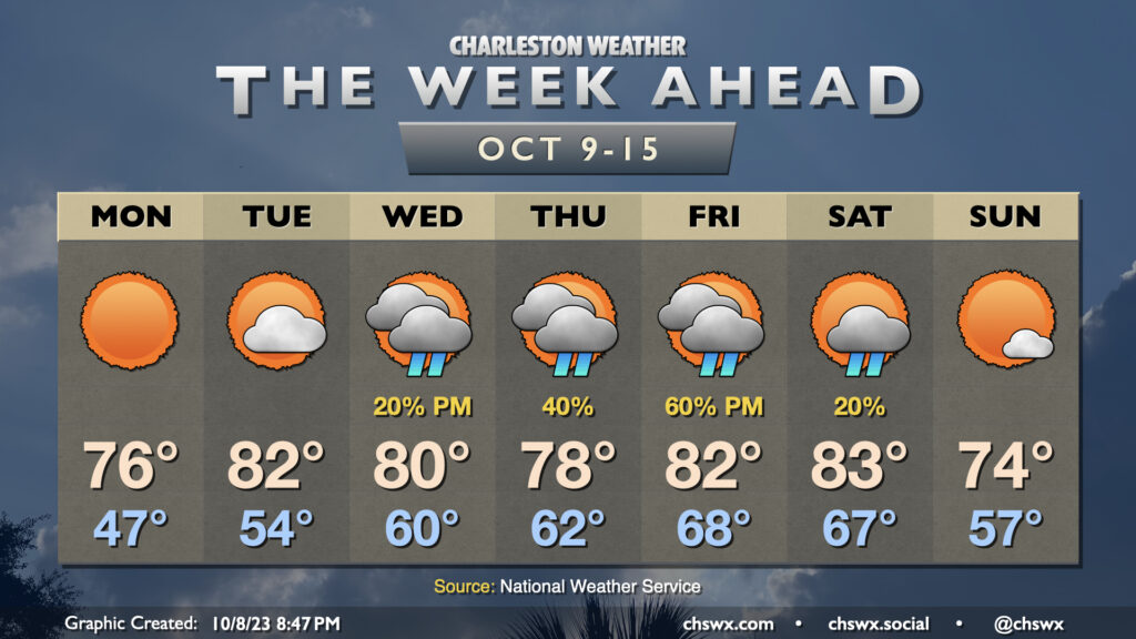
Clouds and temperatures will be on the increase for Tuesday as moisture begins to move back into the area. We start Tuesday in the low 50s before temperatures warm reasonably quickly into the low 80s by early afternoon. We should get plenty of sun for much of the day, though cloud cover will be thickening by evening.
After a day that featured lows in the low 50s and highs topping out just in the low 70s, clear skies and calm winds will allow temperatures across much of the metro area (inland of the coast, anyway) to fall into the 40s for the first time since early May on Monday morning. Sunny skies will prevail throughout the day, and temperatures should reach the mid-70s in the afternoon as a result. Overall, it will be another really nice day across the Lowcountry.
The chill will gradually recede as high pressure shifts offshore during the day Monday. Tuesday will run warmer and a little cloudier, with highs topping out in the low 80s in the afternoon after a mid-50s start. A little more cloud cover works into the area by Wednesday as a jet streak strengthens overhead, which should lead to a few showers later in the day (though there’s a lot of dry air to overcome initially). Shower chances improve into Thursday as low pressure moves eastward out of the Gulf of Mexico. We should see an uptick in cloud cover and a little cooler day as well as high pressure wedges in from the northeast. We’ll stay wedged in for a good bit of Friday, though a warm front should lift northward later in the day. Shower chances will continue and perhaps tick up a bit as the aforementioned warm front gets nearby. A little thunder will be possible, too.
Conditions should gradually improve over the weekend as a cold front gets through late on Saturday, and by Sunday, temperatures head back below normal into the mid-70s under mostly sunny skies. (Frontal timing, of course, will be fine-tuned as the week goes on.)
Big (but brief, for now) changes are incoming for our weather in the wake of a cold front that will get through during the day Saturday. First, though, we may dodge a shower or two in the morning as the front gets by, but from there the trend will be for fewer clouds and an uptick in northwesterly winds. We’ll start Saturday in the mid-60s and warm to the low 80s in the early afternoon before cooler air starts to filter in. Dewpoints will drop precipitously starting in the evening, and by Sunday morning, things are going to feel a lot different.
On Sunday, we’ll get off to the coolest start we’ve had since the morning of May 4 with lows bottoming out in the low 50s across the metro. I wouldn’t be surprised to see some 40s in more rural areas. Full sunshine will be in play, but the cooler air moving in will help counteract it, allowing highs to only climb into the low 70s. Bottom line: Take Saturday to make sure your light jackets or hoodies are ready to go because you may very well need them on Sunday! We keep the cooler air going into Monday, but it will be short-lived and we’ll be back closer to normal by mid-next week.
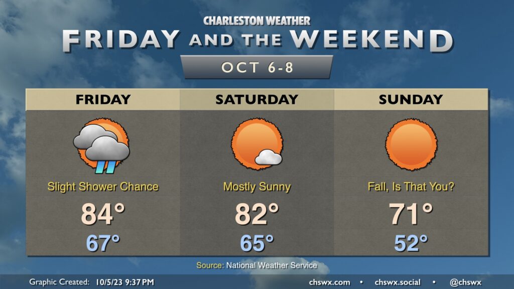
Well, I think we all know what the big weather story will be heading into Friday and the weekend — a really solid shot of cooler and drier air that arrives Sunday for the season’s first true taste of fall. To get there, we’ve got to get through a frontal passage, though limited moisture will keep shower and storm chances relatively low on Friday. Highs top out in the mid-80s after starting in the upper 60s, which is on the mild side of normal for this point in the year. Drier air begins to punch into the area on Saturday, though the cooler air will lag a little bit. Expect Saturday to be a pleasant day, though, with highs topping out in the low 80s in the early afternoon before the cooler air begins to do its thing.
We’ll wake up Sunday in the low 50s, which will be the coolest low since we started May 4th at 48°. Brilliantly sunny skies will aid temperatures getting into the low 70s in the afternoon. It should be a really beautiful day to get out and do stuff. You may very well need a light jacket or hoodie, even. And while this shot of “chilly” air will be somewhat short-lived — we warm back to the 80s by Tuesday — it’s a sign of what’s to come as we get deeper into October and fall.
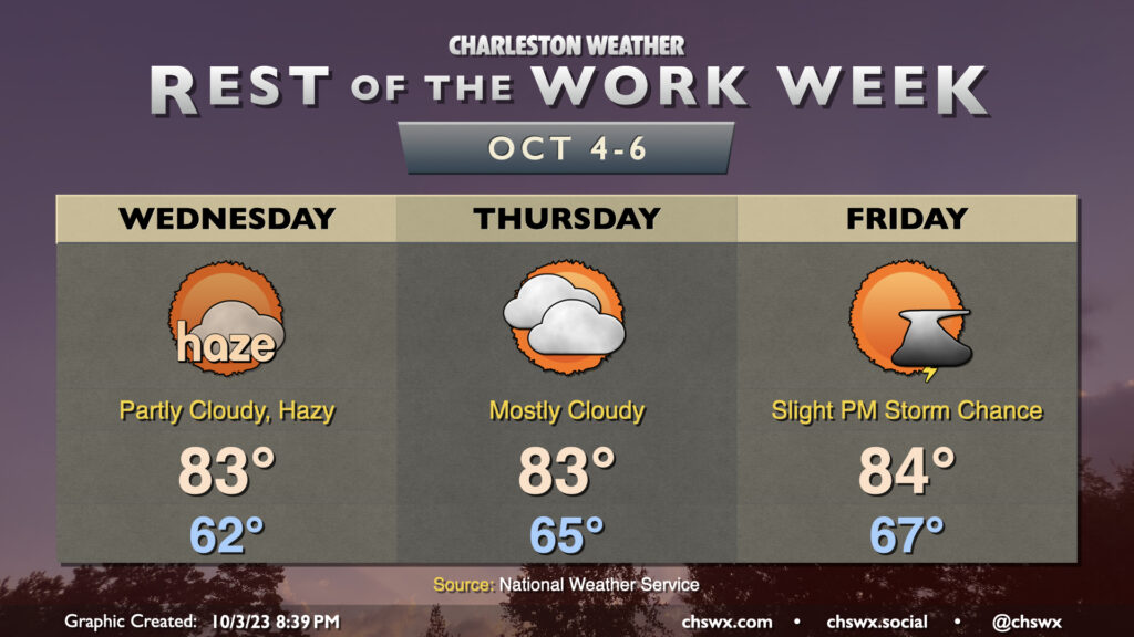
The past couple days have been marred somewhat by wildfire smoke moving southwest from Canada, and it looks like that may persist at least into parts of Wednesday as well. There could be some air quality impacts, so if you are sensitive to particulate matter, you may want to spend a little more time inside. (Masks such as N95s will help here, too!) Smoke aside, the weather is otherwise quiet; lows bottom out in the low 60s once again and head into the low 80s in the afternoon under partly cloudy skies. We’ll also need to keep an eye on the midday high tide for one more round of minor coastal flooding, but that should do it for this stretch of coastal flooding events with some pattern changes in the offing.
We should see improvements with the smoke heading into Thursday, but cloud cover will begin to creep up as a little more moisture starts to work into the area. We should stay rain-free, though a shower might not be totally out of bounds. Highs once again top out in the low-to-mid-80s.
Warmth peaks Friday as ever-so-slightly higher dewpoint air continues to move in. We start the day in the mid-to-upper 60s and top out in the mid-80s with a chance of a shower or thunderstorm or two in the afternoon ahead of an approaching cold front. Said front moves by Saturday, and by Sunday, temperatures are very fall-like.
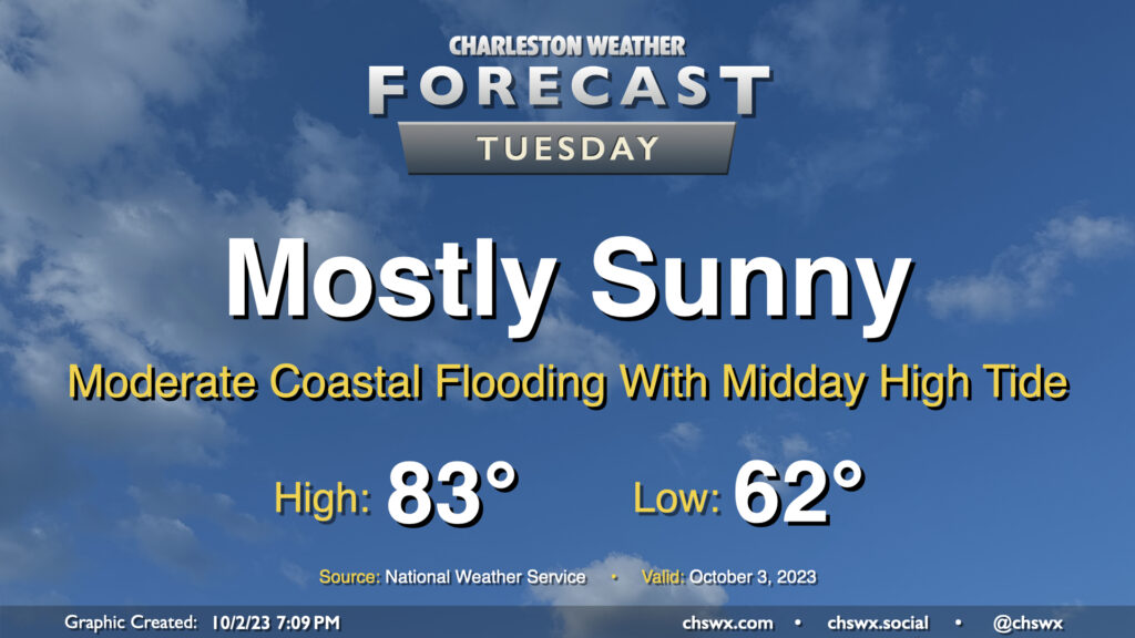
Our solid start to October continues on Tuesday, with mostly sunny skies and comfortable temperatures continuing with high pressure in control. The only potential issue will be the risk for moderate coastal flooding with high tide just before noon; there could be travel disruptions as some of y’all look to grab lunch, so that’ll be something to keep an eye on. Otherwise, though, it’ll be another very nice day.