Jared Smith founded @chswx on Twitter in 2008 as an experiment in disseminating weather data through social media. In the ensuing decade-and-a-half, @chswx has provided live coverage of tropical cyclones, tornadoes, severe weather, and even a couple bouts of winter weather to the good people of Charleston, SC.
Thursday is going to be another hot day across the area. Expect to start the day just barely below 80° inland and likely a couple degrees above it closer to the coast. We’ll warm back into the mid-90s during the day, and with dewpoints not mixing out quite as much — expect them to hang around in the mid-70s — we should see heat indices peak around 110° or so in the afternoon. This is certainly well into the danger zone for heat illness, so please do take it easy if you must be outside. There’s no Heat Advisory as of this writing, but don’t be surprised if one is issued by morning.
Attention then turns to the potential for showers and thunderstorms to move into the area in the afternoon and evening courtesy of a disturbance rounding a retreating ridge of high pressure. Most of these storms should be efficient rainfall and lightning producers, and a few of these storms could be on the strong side with damaging wind gusts the main concern. Hail can’t be ruled out, either. Stay alert to rapidly changing conditions as we get into tomorrow afternoon and evening, and don’t be surprised if there are evening commute impacts.
Fortunately, wildfire smoke will play much less of a role in Thursday’s weather as it continues to disperse southward.
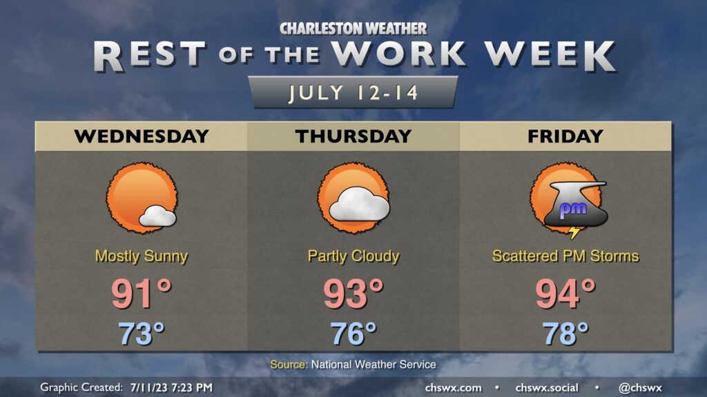
We’ll continue this hot stretch of weather as we get into Wednesday and through the rest of the work week. Expect highs in the mid-to-upper 90s each afternoon with heat indices peaking around 105-110° each day in many spots, with perhaps even higher heat indices closer to the coast where the higher-dewpoint air will be found. Lows won’t offer much in the way of relief — generally expect just upper 70s across much of the metro, with temperatures not going below 80° downtown and at the beaches over the next few days. With drier air aloft, it’ll be hard to get much in the way of thunderstorms to fire along the pinned seabreeze, and they likely won’t be deep enough to really overturn the atmosphere much, possibly leaving even muggier conditions behind them.
Wildfire smoke will once again cloud the sky a little bit on Wednesday, but not quite to the degree that we saw on Tuesday. The air quality forecast is on the lower side of code yellow for Wednesday, but that seems to be primarily due to ozone. As always, we’ll keep an eye on this in case smoke mixes down a little more than expected.
Troughing digs back in across the area over the weekend, which will send temperatures downward and bring rain chances upward, breaking this mini-heat wave. (You either get the heat or storms this time of year — not really a third option!)
We begin a rather hot stretch of weather — yes, even warmer than we’ve been — starting Tuesday as ridging builds aloft. Downslope flow from the northwest will act to warm the air as it sinks as well as help to keep the seabreeze pinned closer to the coast, which will help drive air temperatures well into the mid-to-upper 90s across the area after an already warm start in the upper 70s to around 80° at the coast. Mix in humidity and you’ll find heat indices across the area ranging from about 105-110° during the height of the afternoon. We’ll be in this heat index “danger zone” for a few days, so be sure to take it easy if you have to be outdoors during this time, and get lots and lots of water.
As the ridge builds aloft, this will also help to put a lid on afternoon thunderstorms for the most part; a shower or storm can’t be totally ruled out, but don’t count on one for any sort of heat relief.
Finally, Canadian wildfire smoke will add a milky haze to the overall sky composition. Upstream observations suggest that there could be some minor air quality impacts, but so far no major issues are anticipated. Stay tuned, though.
High pressure will ridge into the area for much of the new week ahead, sending air temperatures up and thunderstorm chances down before weakening into the weekend, bringing back a better chance of afternoon and evening showers and thunderstorms.
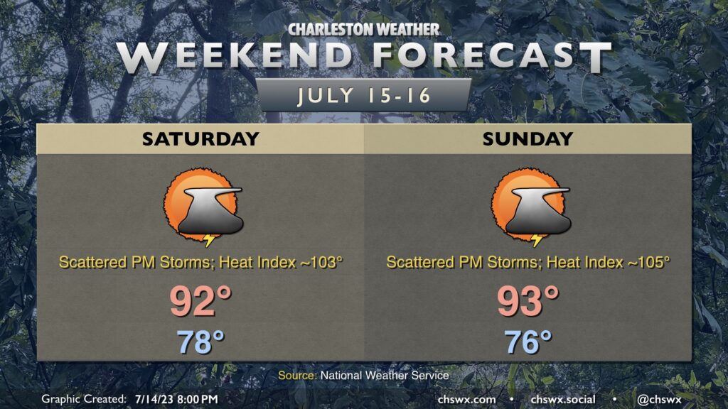
A fairly standard mid-July weekend lies ahead across the metro area. Highs top out in the low-to-mid-90s each day after starting out in the mid-to-upper 70s. The seabreeze will be the main instigator for afternoon and evening thunderstorms; as is customary for this point in the year, heavy rain and frequent lightning are the main threats, with gusty winds possible within the strongest storms. Severe or not, all thunderstorms are dangerous due to the lightning they produce. When thunder roars, go indoors.
Friday and the weekend will feature another round of warm temperatures, with heat indices running 105-110° by the weekend, and a solid chance of thunderstorms each afternoon and evening. We’ll start each day in the upper 70s — perhaps not getting below 80° downtown and at the beaches — before warming to the mid-90s each afternoon. Surface dewpoints running solidly in the mid-70s will yield heat indices approaching 105° on Friday. The weekend should peak even hotter, with heat indices approaching 105-110° each afternoon. Stay tuned for the potential for Heat Advisories from the National Weather Service.
From there, showers and thunderstorms will fire each afternoon along and ahead of the seabreeze. Heavy rain and frequent lightning will be the main concerns, though the stronger updrafts found where outflow boundaries collide could be capable of producing a marginally severe storm or two with damaging wind gusts the main concern. As is often the case in July, it will not rain all day, and some of you may not see rain every day. Just be ready to bring outdoor activities inside in case thunderstorms approach. Severe or not, lightning makes every thunderstorm dangerous. “When thunder roars, go indoors!”
Expect one more generally quiet weather day on Thursday (though a shower or storm can’t be ruled out in the afternoon, especially further inland) before things turn more unsettled as a trough digs in for Friday and the weekend.
Another day or two of quiet weather is expected as deep-layer dry air remains in place over our part of the world, suppressing thunderstorm development and keeping temperatures a little more in check. Wednesday looks pretty good by July standards, with mostly sunny skies and highs in the low 90s expected. Surface dewpoints in the low 70s should yield a peak heat index around 99°, generally after the seabreeze moves by. Thursday will run a degree or two warmer with a little bit more in the way of cloud cover as moisture starts to tick up somewhat. Peak heat indices should run around 100° during the mid-afternoon hours.
We get back to a more traditional July pattern of afternoon thunderstorms on Friday as more humid air begins to work back into the area. We start the day in the upper 70s and top out in the mid-90s before scattered thunderstorms develop in the afternoon and evening hours along the seabreeze. Heat indices could top out above 105°. We’ll keep this going into the weekend, too, with the potential for advisory-level warmth (heat index 110°+ for two hours) and scattered thunderstorms as the main weather concerns for outdoor activities.
Somewhat drier air (aloft, anyway) moving into the area Tuesday will put an end to the soggy weather for a few days, though an isolated afternoon thunderstorm does remain possible. We start the day in the low 70s — the coolest start to a day since June 28 — before warming into the low 90s in the afternoon. While the drier air will provide for generally partly cloudy skies amidst a somewhat brilliant blue sky, it’ll still be fairly humid at the surface; expect heat indices to peak around 100° in the afternoon as the seabreeze moves by. All in all, though, we should have plenty of sun to help sop up this latest round of heavy rain.
The week ahead will feature what passes for a “cooldown” in mid-July followed by a return to temperatures running a few degrees above normal for this point in the year. But first, a soggy Monday as showers and thunderstorms ahead of a cold front take center stage. Some very heavy rain is possible, with another 1-2″ of rain possible across the area with locally higher amounts. We’ll have to watch for the potential for flooding as storms could train across some of the same spots repeatedly; there is also the matter of the 3:07 PM high tide to be concerned about, too, for downtown Charleston. The clouds and rain will keep highs in the mid-80s for the first time since June 23rd, so at least there’s a brief break from the heat. (Silver linings, etc.)