Jared Smith founded @chswx on Twitter in 2008 as an experiment in disseminating weather data through social media. In the ensuing decade-and-a-half, @chswx has provided live coverage of tropical cyclones, tornadoes, severe weather, and even a couple bouts of winter weather to the good people of Charleston, SC.
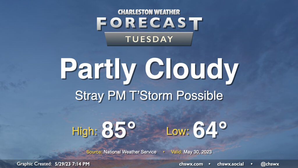
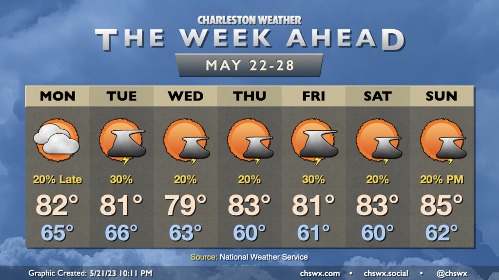
After what’s turned out to be a really beautiful Memorial Day, we head back to work and school on Tuesday with similar, if not slightly warmer, weather expected. We’ll start the day a few degrees warmer — generally around the mid-60s — and highs should warm to the mid-80s in the afternoon. There’s a risk for a stray shower or thunderstorm in the later afternoon and early evening hours as the seabreeze gets rolling, but otherwise, the vast majority of us get Tuesday in rain-free as well.
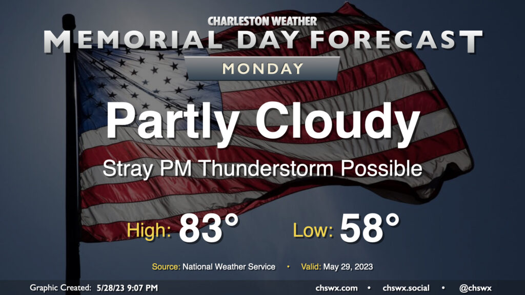
The sun will make a return to our skies for Memorial Day as surface low pressure continues to move away from the area and westerly winds dry things out a bit. We start the day much cooler than normal, with lows bottoming out in the upper 50s. (The record low of 53° set in 1961 remains safe.) Sunshine and the aforementioned westerly winds should help highs top out in the low 80s — a couple ticks below normal as well, but certainly much more seasonable than the 60s and 70s of recent days. The only fly in the ointment may be a stray thunderstorm or two in the afternoon as the seabreeze moves inland. If the beach is in your Memorial Day plans, keep an eye out later in the afternoon as storm motions will be toward the coast. Otherwise, no concerns.
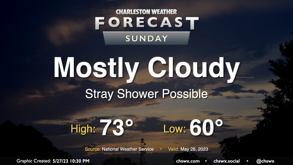
We are through the worst of our experience with the coastal storm that has been bothering us for the better part of two days, and improvement will start to show itself on Sunday. We should see showers mostly shut down around daybreak or so, but I’m not sure a stray or two can be totally discounted throughout the day. We should start to see some breaks in the clouds, and by the evening, I suspect we’ll have at least some sunshine to close out the day. Temperatures will remain well below normal for this point in the year, topping out in the low 70s after starting the day around 60°.
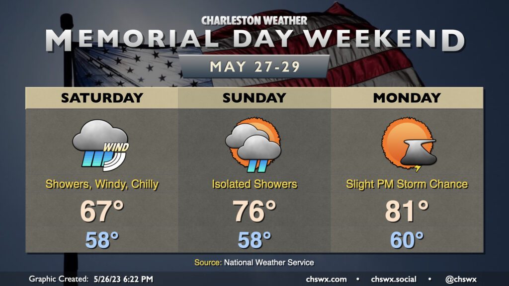
Well, this is a really unusual Memorial Day weekend forecast, to put it mildly. Showers will be ongoing as we wake up Saturday with gusty winds and quite a chill in the air. We start the day in the upper 50s — well below normal for this point in the year. Showers and north winds will keep temperatures capped in the mid-60s. To give you a general idea of how abnormal this is for this point in May, the normal low is 66°, and the NWS forecast is 67°. That’ll be one degree off the record low maximum if it verifies.
Wet weather will kick off the Memorial Day weekend as a low pressure system rides up the coast and affects the Carolinas with heavy rain, gusty winds, rough surf, strong rip currents, and very hazardous marine conditions. It’s also going to be very unseasonably cool, at least to start — think highs in the 60s for Saturday. (Seriously.)
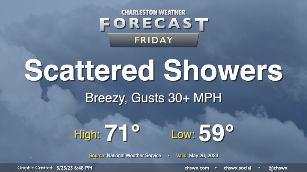
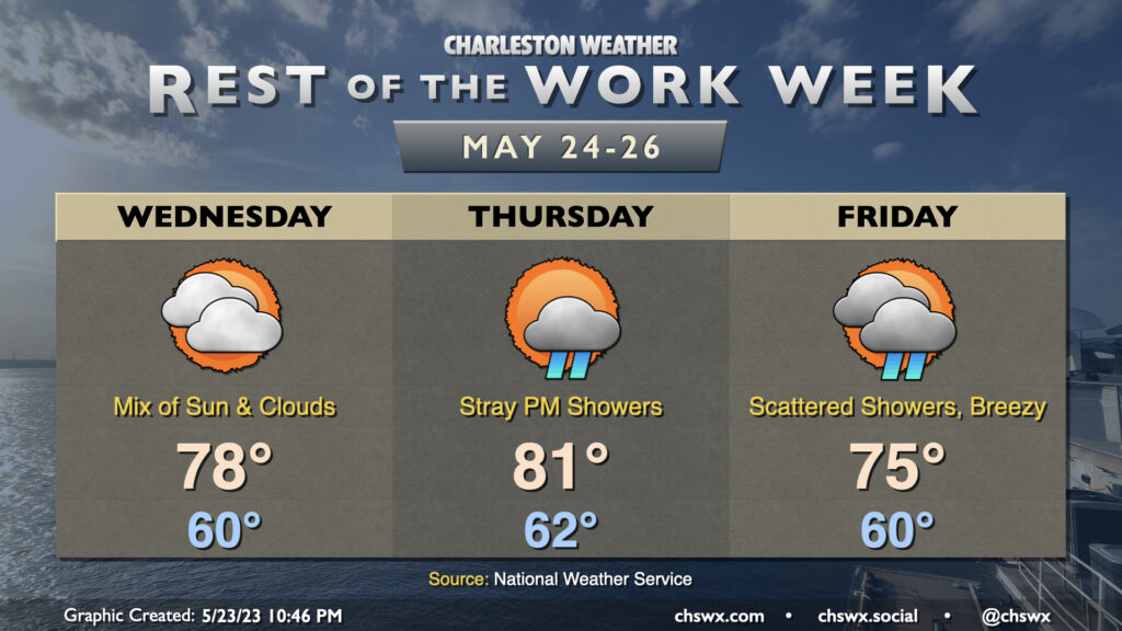
Friday will start in the upper 50s (the normal low for May 26 is 66°, for comparison) and only warm to the low 70s with cloud cover and increasing shower activity throughout the day. Winds will be breezy, coming in from the northeast around 20 MPH with higher gusts. The best chance for showers will begin in the evening hours and last well into Saturday as the low pressure system comes ashore somewhere between Charleston and Wilmington.
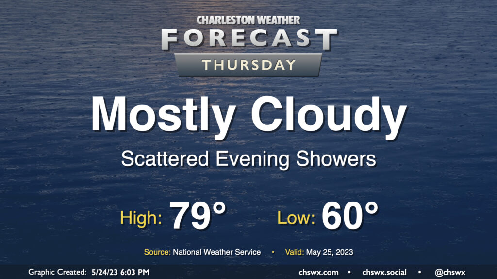
We start to see a shift toward more unsettled weather beginning Thursday as low pressure begins to organize offshore, sending more moisture and some windy conditions our way. We start the day around 60° as high pressure remains wedged in place. We’ll get a fair bit of the day in rain-free as highs top out around 80° in the afternoon. As low pressure begins to organize offshore later Thursday, we’ll start to see a risk for a few evening showers.
Our run of unusually cool late-May weather continues through the end of the work week as high pressure continues to wedge into the area from the northeast. Wednesday should look a fair bit like Tuesday did, but with even more dry air that should preclude any popup showers. After a seasonably cool start around 60°, highs look to top out in the upper 70s with a mix of sun and clouds with northeasterly winds around 5-10 MPH.
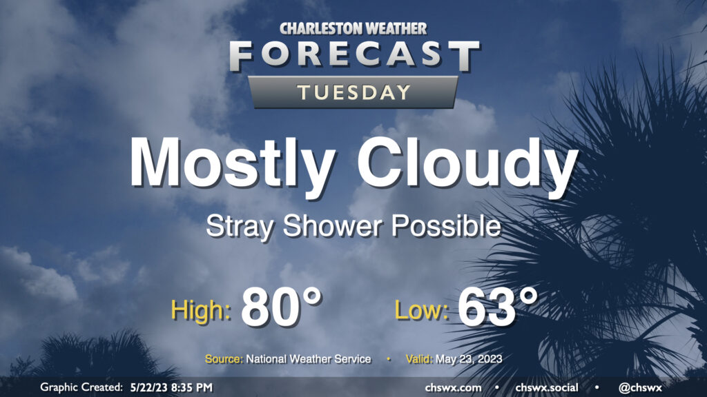
Cool high pressure remains in control for Tuesday bringing partly to mostly cloudy skies and highs well below mid-to-late-May normals. We’ll start the day in the low 60s before temperatures head to just about 80° in the afternoon — we’re normally looking at highs in the mid-80s at this point in the year. A stray shower could develop in the afternoon, but models show a pretty deep dry slot aloft that should preclude widespread precipitation.
One thing you might notice right away when peering at the week ahead is that temperatures for the week ahead look more like early May as opposed to late May. Highs will generally top out in the low 80s for much of the week (and Wednesday might not even crack 80°!) as cool high pressure builds into the area and stays in force. Upper-level disturbances swinging through will keep isolated to scattered thunderstorm chances in the forecast, primarily in the afternoons (though some popup showers can’t be ruled out in the mornings, either).
The second half of the week will have some details to iron out regarding an area of low pressure that will move northward, parallel to the coast. The question ultimately is how far west it gets; it may spread some gusty rains ashore Thursday into Friday if it gets a little too close. Stay tuned for forecast updates.
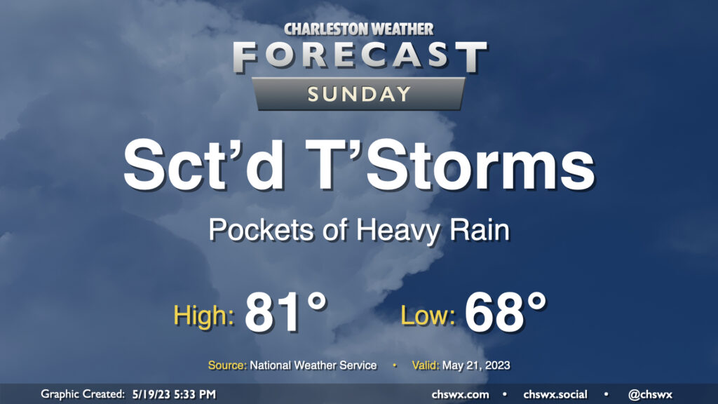
Sunday’s forecast brings unsettled weather back to the area as a cold front presses south into the region. We start the day on the mild side, with lows bottoming out in the upper 60s — a few clicks above normal still for this point in May. Highs top out in the low 80s before showers and thunderstorms begin to make inroads. Showers could spread into the area as early as mid-morning, though the more likely onset will be from midday into early afternoon. Evening high-resolution guidance, coming in as I write this, has been trending a little drier, with the bulk of the heavier rain across the Savannah River in Georgia where dewpoints pool ahead of the cold front, but a lot will depend on the speed of the front and how it coincides with some energy aloft. Still, be ready to turn outdoor plans into indoor plans on short notice, and watch for pockets of heavy rain at times, too.