Weekend forecast: Big chill incoming
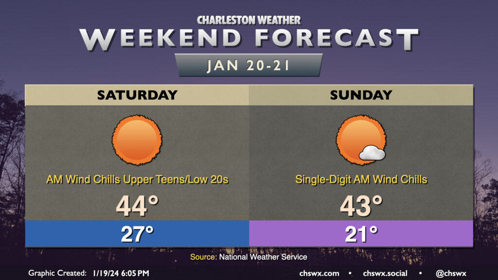
A rather cold weekend lies ahead as Arctic high pressure visits the Lowcountry, especially Saturday night into Sunday, which will require cold weather precautions for the next few nights.
Read more »Forecast explanations, atmospheric science, and other cool weather-related stuff for Charleston, SC
A rather cold weekend lies ahead as Arctic high pressure visits the Lowcountry, especially Saturday night into Sunday, which will require cold weather precautions for the next few nights.
Read more »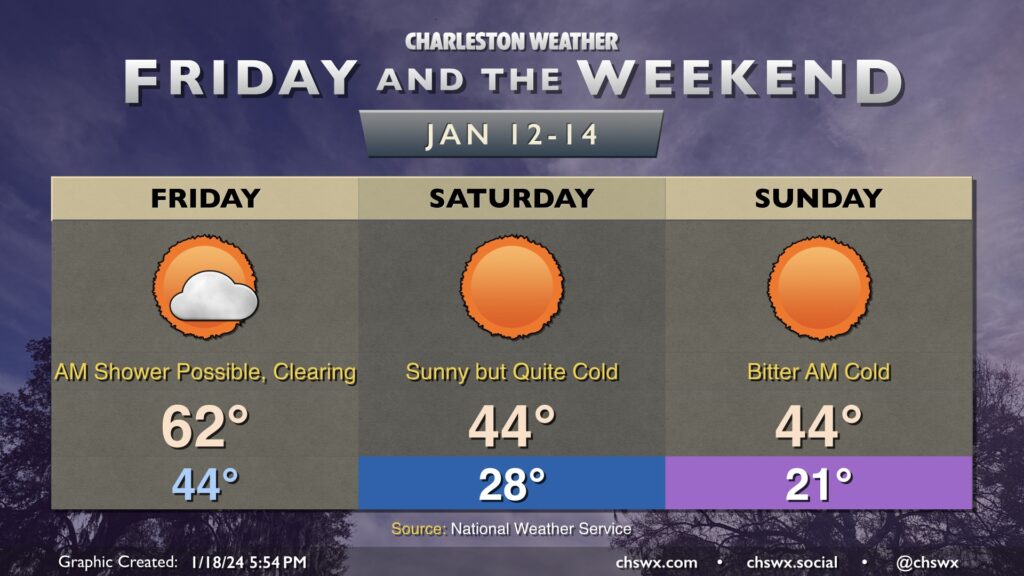
Friday will be the last time for a few days that we’ll start the day above freezing. The day starts in the mid-40s, and there’s a risk for a stray shower or two in the morning. Most will stay rain-free, though. Temperatures will head into the low 60s by early afternoon as a cold front swings through, ushering in drier air that will help scour out the cloud deck. It’ll be windy — gusts 25-30 MPH certainly appear possible as well, so keep that in mind as you commute over bridges.
We’ll start to cool off by late afternoon, and will be quickly into the 40s by 7PM. From there, we will chill out rapidly, and temperatures will fall into the upper 20s by morning. Wind chills will drop to around 20° — and perhaps lower — and could be nasty for morning runs or the like. Temperatures only head to the mid-40s in the afternoon despite full sunshine.
Saturday night into Sunday will feature the coldest temperatures. Lows will fall to the upper teens to low 20s, and wind chills could drop to around 10° or even lower in the morning. A Wind Chill Advisory is probable Sunday morning. Cold weather precautions will be a must: protect plants, pets, pipes, and people. Temperatures on Sunday will head back to the mid-40s in the afternoon, which might feel downright balmy after how the morning will start!
After one more freezing start Monday, though, we warm up — and the 70s look to be back on Wednesday.
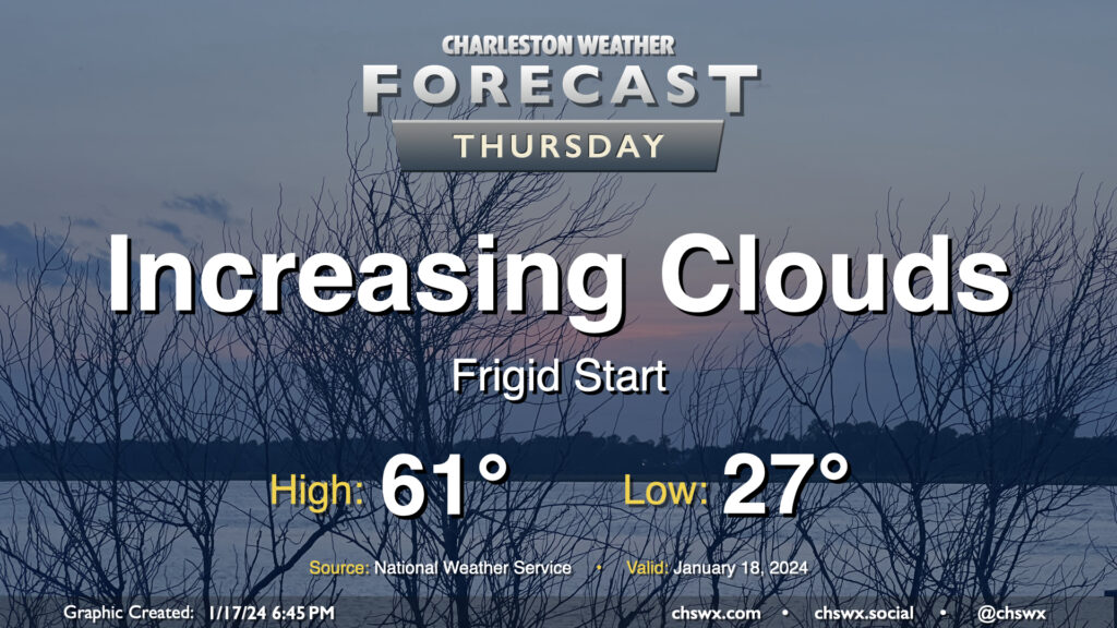
Thursday will get off to a very chilly start across the Lowcountry as calm winds and clear skies combine to allow for a solid radiational freeze across the area tonight into Thursday morning. Expect lows to bottom out in the mid-20s in a fair bit of the metro, with slightly warmer — but still at or very near freezing — temperatures near the coast. Bring pets in tonight and cover sensitive plants. Consider dripping a faucet, too, especially further inland.
The good news is that temperatures won’t stay below freezing for long after the sun comes up. High pressure will move offshore, allowing temperatures to recover to the low 60s by afternoon as cloud cover increases. There is a risk for a few showers very late Thursday into early Friday, but we’ll get the daytime hours in rain-free.
Read more »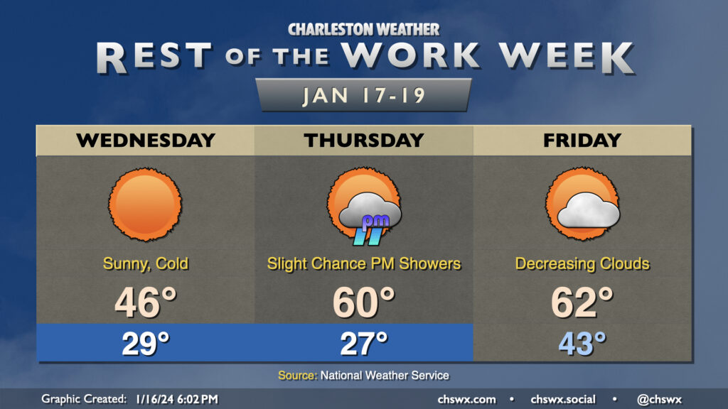
A rather cold day awaits on Wednesday despite full sunshine throughout the day as chilly high pressure builds into the area. Temperatures should fall to the upper 20s in the metro area early Wednesday morning as cold air blows in. Wind chills will bottom out in the low 20s, so be sure to dress accordingly as you head out to work or school. Afternoon highs will struggle to the mid-40s as cold air continues to settle into the area throughout the day. Despite light rain during the day Tuesday, black ice doesn’t look like it will be a factor given that we’ll be drying out very quickly tonight as dewpoints plummet into the 20s.
We’ll dip a little further into the 20s overnight Wednesday into Thursday morning. Temperatures should reach freezing by late evening, and should stay there through sunrise, with roughly an 8-10 hour period of freezing temperatures a decent possibility. It’ll be a good idea to keep a faucet on a drip, make sure pets are in a warm place, and ensure plants are protected. The good news is that the freeze will quickly give way to warmer temperatures Thursday afternoon, with highs expected to peak around 60°. A few showers will be possible in the late afternoon into the evening hours, but very little overall rainfall is expected.
Friday will be the only day in the next few that’ll start above freezing; expect lows in the low 40s in the morning, followed by highs in the low 60s in the afternoon. A cold front will advance through the area roughly midday or so, but the coldest air will be delayed a little bit. Still, expect clouds to scour out as drier air moves in.
Read more »