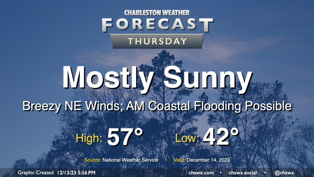
Reinforcing strong high pressure building into the area on Thursday keeps our weather generally cool and quiet, though winds will be blustery and there will be a coastal flooding risk in the morning.
Lows will dip only to the low 40s owing to breezy conditions restricting better radiational cooling. However, cool air pushing in from the northeast will keep highs capped to the upper 50s despite plenty of sunshine. Combine that with an increasingly stiff breeze — 15-20 MPH in the metro, with higher gusts — and you’ll be glad for a jacket with some wind-breaking capability. At least the sun will be out, and the sky should be largely unmarred by any cloud cover.
High tide around 8:37am will get high enough for minor to perhaps moderate coastal flooding smack dab in the middle of the commute. Be ready for possible road closures if downtown is in your commute plans. I’d also be cautious around Long Point Road near Snee Farm as water levels could approach thresholds to flood that road as well. Coastal flooding will remain a concern for the next few mornings, especially as we get into the weekend.
Another chilly start is in store for Wednesday as high pressure to our north keeps some cool air blowing into the area throughout the night. This will send temperatures down to the mid-30s once again, with another shot at freezing in a few more secluded spots. Wind chills will dip below 32° at times in the morning, so be sure to dress appropriately. The good news is that we warm up some compared to Tuesday, heading to the low 60s in the afternoon under partly cloudy skies.
The brief warmup doesn’t last long, though: a reinforcing cold front comes through overnight Wednesday into Thursday, ushering in strong high pressure that will not only reinforce the chill — expect highs just to top out in the mid-to-upper 50s — but also kick up the northeasterly winds, which will start to drive tidal departures higher as well, which may lead to minor to moderate coastal flooding in the morning. This strong high pressure will lead to another mid-30s start on Friday, with highs struggling to the upper 50s despite mostly sunny skies. We’ll also need to watch Friday morning’s tidal departures for the risk for additional coastal flooding.
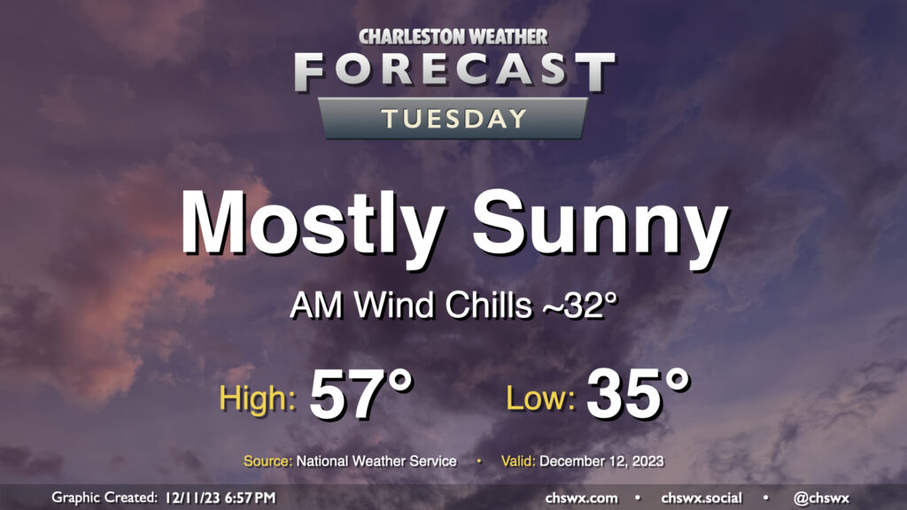
Tuesday will be another sunny day across the area, though you’ll want a jacket as cooler-than-normal temperatures continue. We start the day in the mid-30s, but the wind chill will make it feel around freezing. Some spots well inland could hit freezing, too. Bring in your pets tonight and cover or bring in any sensitive plants, just in case. Temperatures then warm once again to merely the mid-to-upper 50s despite mostly sunny skies as cool high pressure persists. This runs a few degrees below normal; the normal high for December 12 is 63°.
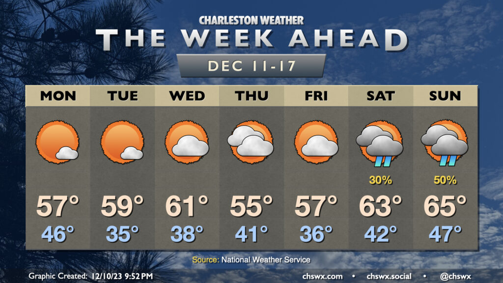
A cold front getting through overnight Sunday will clear the area by daybreak Monday, ushering in much cooler and drier air and setting up a week of below-normal temperatures. Clouds will be scouring out Monday morning, yielding abundant sunshine, but cold advection will keep temperatures capped to the mid-to-upper 50s in the afternoon.
Tuesday morning will start in the mid-30s — about 10° cooler than Monday morning — and could dip into freezing territory further inland. Highs will run a touch warmer, but only in the upper 50s to around 60° under mostly sunny skies. Temperatures moderate a little more on Wednesday before a reinforcing cold front swings through, sending Thursday’s highs down to the mid-50s with an increase in cloud cover, though dry air will preclude any rain with this front. Highs in the 50s continue to close out the work week.
As we get into the weekend, we warm up some, but the weather may turn unsettled once again as a coastal trough may develop with assistance from a storm system in the Gulf. It seems 2023 wants to go out the way it came in — with a continuous pattern of unsettled weekends. Not cool, 2023.