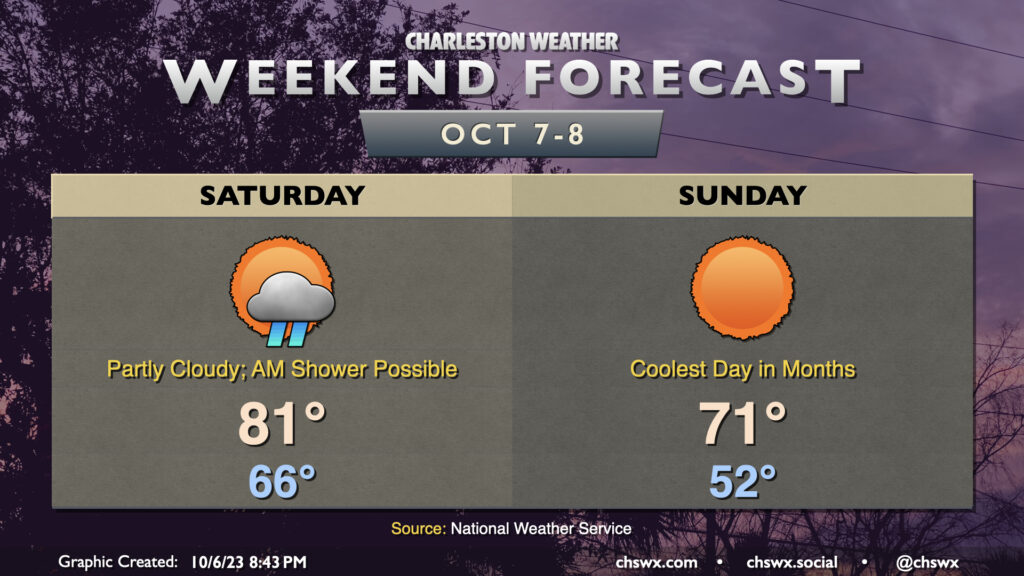
Big (but brief, for now) changes are incoming for our weather in the wake of a cold front that will get through during the day Saturday. First, though, we may dodge a shower or two in the morning as the front gets by, but from there the trend will be for fewer clouds and an uptick in northwesterly winds. We’ll start Saturday in the mid-60s and warm to the low 80s in the early afternoon before cooler air starts to filter in. Dewpoints will drop precipitously starting in the evening, and by Sunday morning, things are going to feel a lot different.
On Sunday, we’ll get off to the coolest start we’ve had since the morning of May 4 with lows bottoming out in the low 50s across the metro. I wouldn’t be surprised to see some 40s in more rural areas. Full sunshine will be in play, but the cooler air moving in will help counteract it, allowing highs to only climb into the low 70s. Bottom line: Take Saturday to make sure your light jackets or hoodies are ready to go because you may very well need them on Sunday! We keep the cooler air going into Monday, but it will be short-lived and we’ll be back closer to normal by mid-next week.
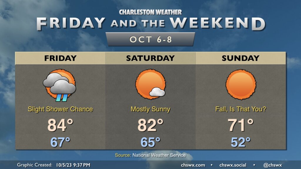
Well, I think we all know what the big weather story will be heading into Friday and the weekend — a really solid shot of cooler and drier air that arrives Sunday for the season’s first true taste of fall. To get there, we’ve got to get through a frontal passage, though limited moisture will keep shower and storm chances relatively low on Friday. Highs top out in the mid-80s after starting in the upper 60s, which is on the mild side of normal for this point in the year. Drier air begins to punch into the area on Saturday, though the cooler air will lag a little bit. Expect Saturday to be a pleasant day, though, with highs topping out in the low 80s in the early afternoon before the cooler air begins to do its thing.
We’ll wake up Sunday in the low 50s, which will be the coolest low since we started May 4th at 48°. Brilliantly sunny skies will aid temperatures getting into the low 70s in the afternoon. It should be a really beautiful day to get out and do stuff. You may very well need a light jacket or hoodie, even. And while this shot of “chilly” air will be somewhat short-lived — we warm back to the 80s by Tuesday — it’s a sign of what’s to come as we get deeper into October and fall.
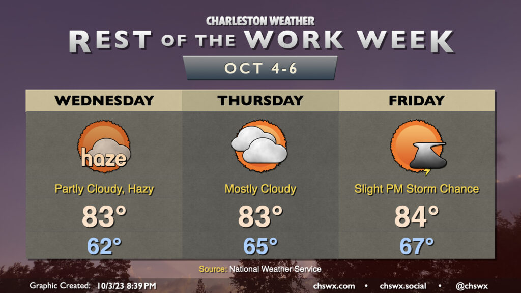
The past couple days have been marred somewhat by wildfire smoke moving southwest from Canada, and it looks like that may persist at least into parts of Wednesday as well. There could be some air quality impacts, so if you are sensitive to particulate matter, you may want to spend a little more time inside. (Masks such as N95s will help here, too!) Smoke aside, the weather is otherwise quiet; lows bottom out in the low 60s once again and head into the low 80s in the afternoon under partly cloudy skies. We’ll also need to keep an eye on the midday high tide for one more round of minor coastal flooding, but that should do it for this stretch of coastal flooding events with some pattern changes in the offing.
We should see improvements with the smoke heading into Thursday, but cloud cover will begin to creep up as a little more moisture starts to work into the area. We should stay rain-free, though a shower might not be totally out of bounds. Highs once again top out in the low-to-mid-80s.
Warmth peaks Friday as ever-so-slightly higher dewpoint air continues to move in. We start the day in the mid-to-upper 60s and top out in the mid-80s with a chance of a shower or thunderstorm or two in the afternoon ahead of an approaching cold front. Said front moves by Saturday, and by Sunday, temperatures are very fall-like.
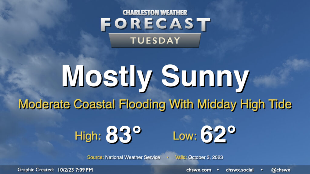
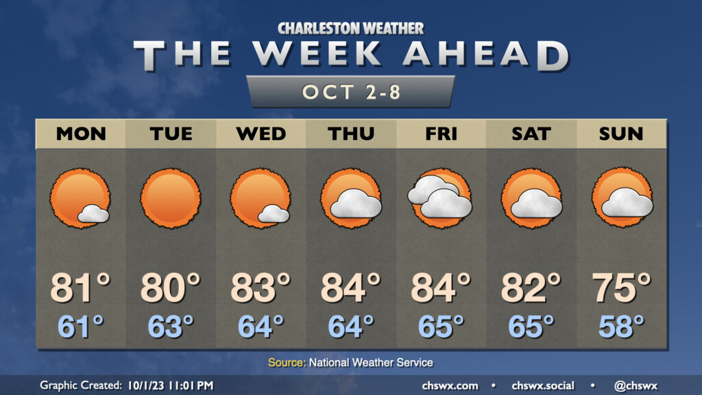
Our solid start to October continues on Tuesday, with mostly sunny skies and comfortable temperatures continuing with high pressure in control. The only potential issue will be the risk for moderate coastal flooding with high tide just before noon; there could be travel disruptions as some of y’all look to grab lunch, so that’ll be something to keep an eye on. Otherwise, though, it’ll be another very nice day.
A blocking pattern aloft will keep our weather relatively quiet for much of the week before a front approaches heading into the weekend, which might deliver the first real shot of fall weather to the area for early next week.
Cloud cover will generally be sparse through Wednesday as high pressure remains firmly in control across the area. Our mornings will generally start in the low to mid-60s with highs topping out in the low 80s each afternoon with plenty of sunshine to be had. Cloud cover begins to tick up a bit for Thursday into Friday as the aforementioned front begins to approach the area. It remains to be seen just how much moisture moves back into the area; for now, the forecast remains rain-free, though it wouldn’t shock me to see some shower or thunderstorm chances added as we head into Friday. Saturday should feature decreasing clouds, and then it looks like a reinforcing shot of cooler air moves in for Sunday that could knock temperatures well below normal for this point in the year. We aren’t into sweater weather yet, but we’re making progress!
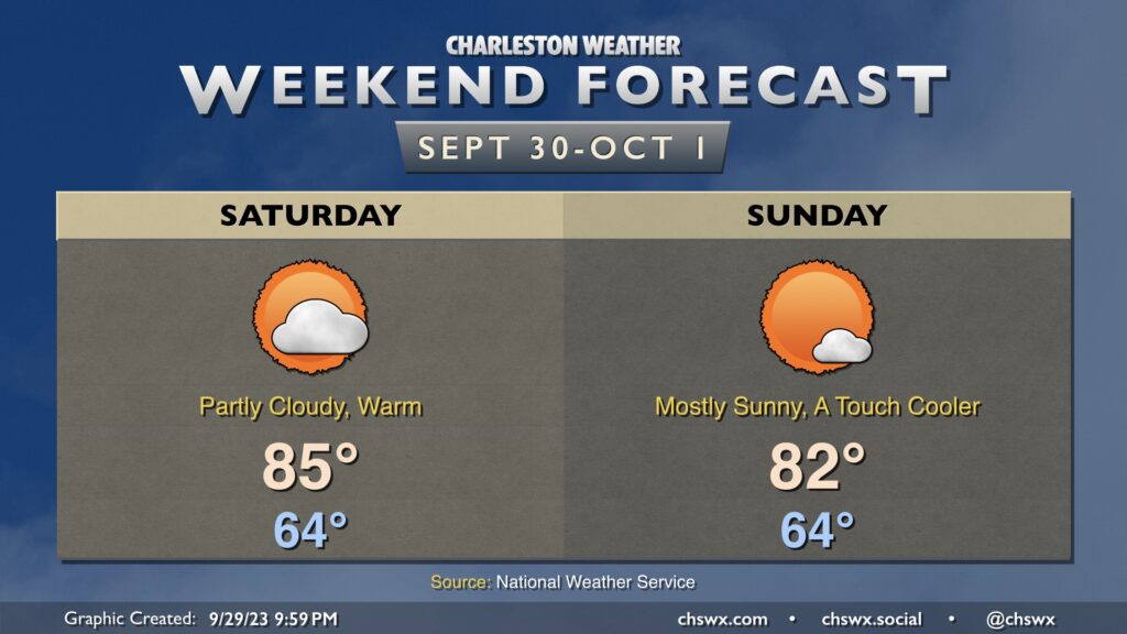
Overall, the weekend forecast is looking solid for doing stuff outside. Expect comfortable starts in the mid-60s (warmer at the beaches), more than ample sunshine (especially Sunday), and warm afternoons with high pressure in control. Saturday looks to be the warmest day of the set with highs topping out around 85° in the afternoon. A reinforcing round of slightly cooler air moves in for Sunday, and that will help cap highs in the low 80s.