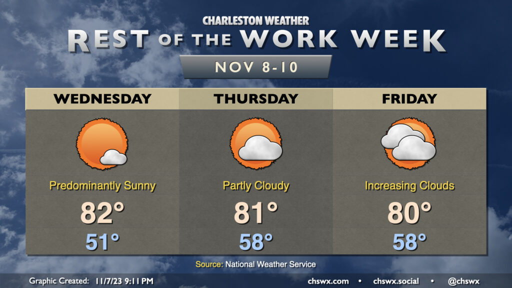
We have a few more days of above-normal warmth before changes in the form of a cold front and subsequent wedge of high pressure arrive for the weekend. For Wednesday, expect another predominantly sunny day starting around 50-51° before warming to the low 80s in the afternoon. Thursday gets off to an even warmer start as lows bottom out in the upper 50s. A few more clouds will dot the sky on Thursday, but we should still have no trouble reaching 80-81°.
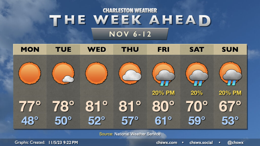
Cloud cover continues to increase as we head into Friday, which will be the last of this long stretch of above-normal temperatures (for now, anyway). High temperatures will run in the low 80s for one more day as warm air pumps into the area ahead of a cold front. It increasingly appears we’ll stay rain-free Friday as the front looks to pass through Saturday morning, bringing with it a few showers and much cooler temperatures for the weekend into next week. It won’t be much in the way of rain, but any little bit helps as abnormally dry conditions continue to spread across the area.
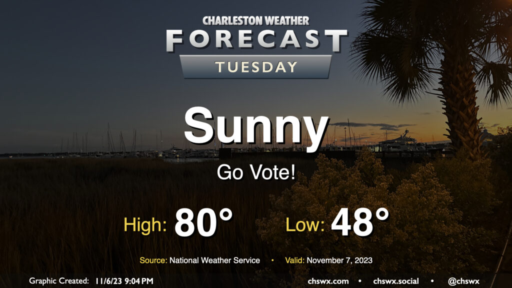
No concerns for Tuesday’s weather as we head to the polls for various local elections — not even any tidal flooding to speak of. We’ll start the day with a light jacket and shed it by midday as highs head to around 80° in the afternoon. Unfettered sunshine will be the rule with a light west to southwest breeze throughout the day.
The warming trend that began this past weekend continues for much of the upcoming week, but a front will bring along some cooler air — and maybe a few showers — as we head into the weekend.
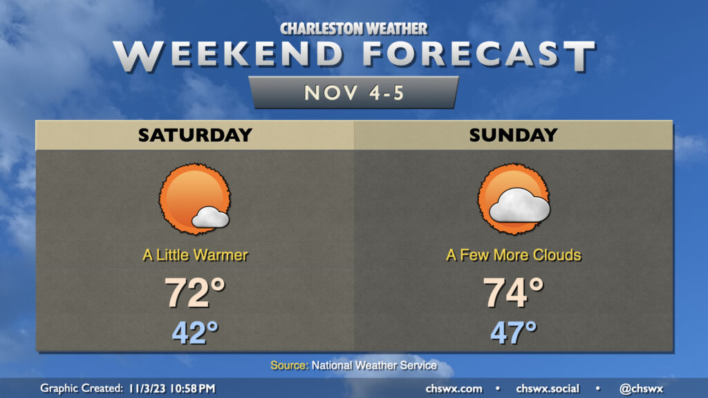
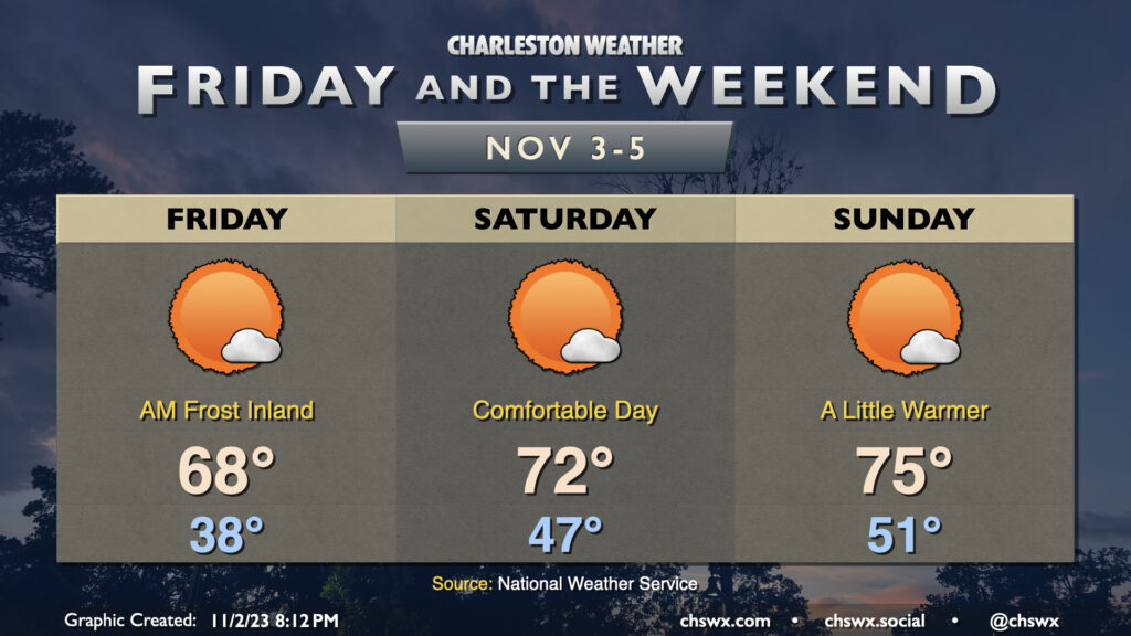
Another beautiful weekend lies ahead as dry high pressure remains in control at the surface. The warming trend that really started to show itself on Friday continues into the weekend. We start Saturday in the low 40s across much of the metro area, with upper 30s further inland and lows near 50° toward the coast. Temperatures will then head into the low 70s in the afternoon under mostly sunny skies.
Don’t forget to set your clocks requiring manual intervention an hour back before you head to bed Saturday night as Daylight Saving Time ends at 2am Sunday. We’ll see temperatures in the mid-to-upper 40s as the sun comes up around 6:40 am, warming nicely into the mid-70s by afternoon. We’ll see a few more clouds as a trough swings through aloft, but the deep-layer dry air closer to the surface will keep us rain-free. The sun will set Sunday evening around 5:30, and it’ll be February 10 before we see another 6PM or later sunset. (Alas.)
Overall, though, it will be a great weekend to get back out and about. Remember how we couldn’t get a dry weekend to save our lives to start 2023? Seems like a distant memory with the great weekends we’ve had as of late — try to take advantage!
We’ll get Friday off to a slightly frosty start in some parts away from the coast as lows dip into the 30s once again with a little bit more moisture to work with and a little less in the way of wind (though wind chills could still dip into the low 30s). A Frost Advisory is in effect for inland Berkeley and Dorchester for Friday morning where the risk for frost will be greatest, so ensure you’ve got sensitive plants covered just in case. From there, though, we’ll warm into the upper 60s in the afternoon (and 70° might not be totally out of the question, either) under mostly sunny skies.
The warming trend continues Saturday. We start the day in the mid-to-upper-40s — almost ten degrees warmer than Friday. Highs should get into the low 70s under mostly sunny skies — a very nice day to get outside, it looks like.
We turn even a little warmer for Sunday. Expect Sunday to start out around 50-51° or so, warming to the mid-70s in the afternoon. A few clouds will dot the skies from time to time, but it’ll be another day of brilliant sunshine.
We’ll be getting that sunshine in an hour earlier than Saturday, though, as Daylight Saving Time ends at 2am Sunday, sending us back into Eastern Standard Time (UTC-5). The sun will rise around 6:40am, but will set just shy of 5:30pm. Be sure to set clocks needing manual changes back an hour Saturday night. It’s a good time to change batteries in your weather radios and smoke detectors as well.
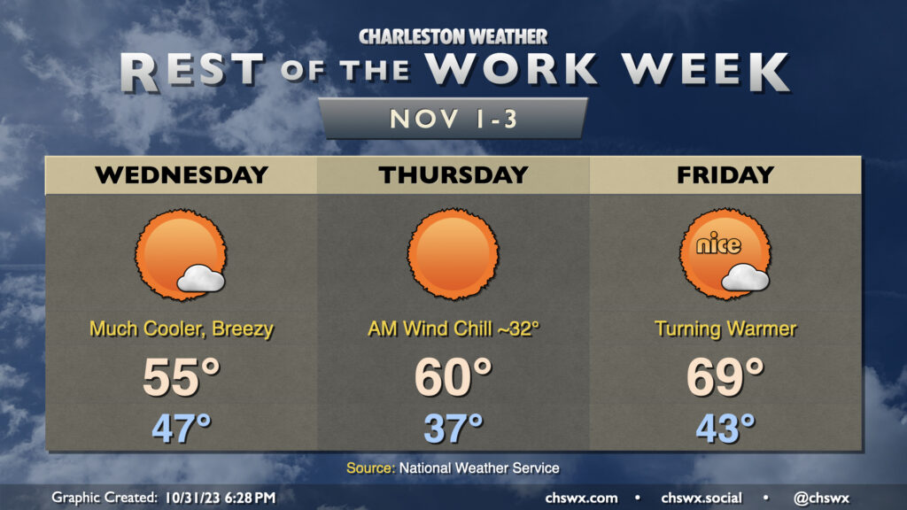
Thursday gets off to the coldest start since March with lows expected in the mid-30s across much of the metro area. Further inland and in more sheltered locations, it’s quite possible that we’re going to see temperatures fall below freezing. A Freeze Warning is in effect for inland Berkeley and Dorchester for Thursday morning; be sure you’re protecting plants and pets. Add in winds around 5-10 MPH, and we’re talking wind chills in the 20s in many spots. Dress appropriately as you head out tomorrow morning!
From there, temperatures will head to the low 60s in the afternoon despite mostly sunny skies. It’ll ultimately be yet another sweater-worthy day across the area with a continued north to northeasterly breeze.
Legitimate sweater weather arrives Wednesday as the coldest air of the season thus far moves into the area. We start the day in the mid-40s but don’t expect temperatures to climb too much beyond the mid-50s despite lots of sunshine. In fact, we may at least tie a different kind of record high on Wednesday — the record low maximum temperature for November 1, which was also 55° last set in 2014.
Thursday looks to get off to the coldest start since early March, and a continued north to northeasterly breeze will drive the wind chill down to around or even below freezing. Dress accordingly in the morning! From there, highs will run a few degrees warmer than they did on Wednesday, but that’s not saying much as we’ll still see temperatures struggle to reach 60° despite unencumbered insolation. The record low maximum of 58° on Thursday is probably safe, but it’ll be close.
The airmass starts to moderate on Friday, though, as warmer air begins to work back into the area. We start Friday in the low 40s before warming to the upper 60s to around 70° in the afternoon under mostly sunny skies. The warming trend continues into the weekend, too, as we head back to the 70s each afternoon under partly cloudy to mostly sunny skies.