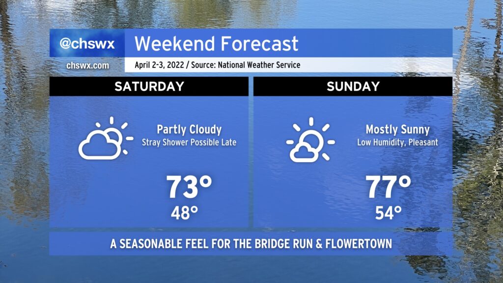
We’ve got another winner of a weekend (weather-wise, anyway) in the cards, with seasonable temperatures in the low-to-mid 70s each afternoon and an appropriate mix of sun and clouds. The only fly in the ointment in this forecast could be a stray shower or two later Saturday evening primarily near the coast, but the chances of any one spot seeing rain are rather slim. Humidity will continue on the low side, too.. We truly couldn’t ask for much better weather for the Bridge Run and Flowertown Festival in Summerville this go-around. (Bridge runners, here’s your hourly forecast for the race.) Enjoy the weekend!
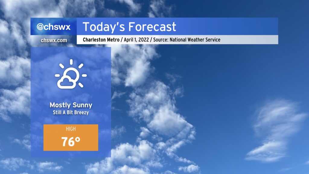
After another extraordinarily windy day yesterday — certainly seems to be quite the trend in 2022 — April begins with generally quieter weather as a cold front slips offshore and dry high pressure builds in. Cloud cover will decrease throughout the day, and temperatures will warm into the mid-70s, making for a rather pleasant day of weather across the Lowcountry. Winds will remain elevated today in the wake of the front, but will decrease as time goes on, and will certainly be nothing like the gusts we saw yesterday, which consistently peaked over 40 MPH and nearly touched 70 MPH on the Don Holt Bridge.
All looks good for the Bridge Run Saturday morning, and overall expect a nice weekend of weather aside from a slight shower chance late Saturday. More details later today.
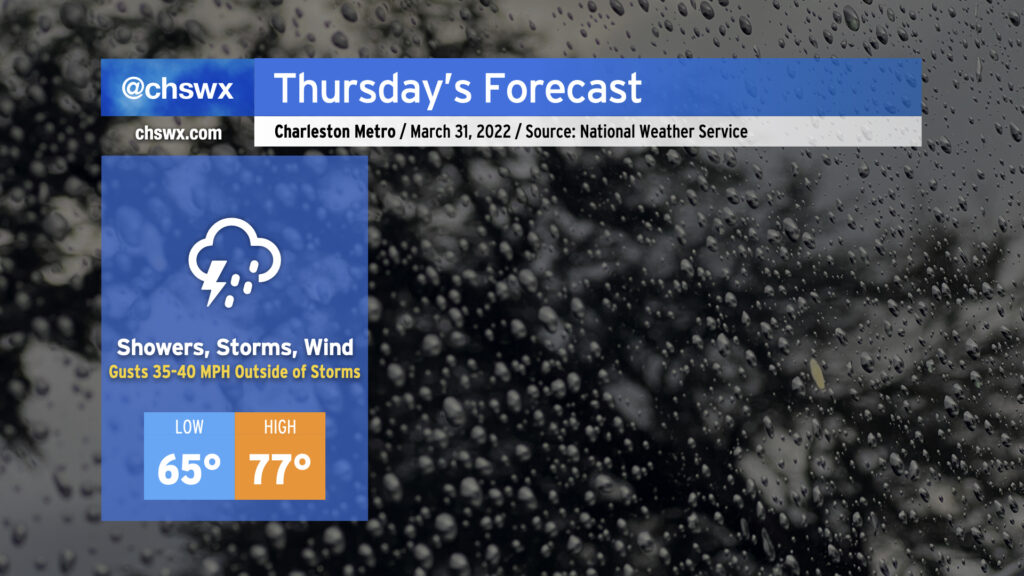
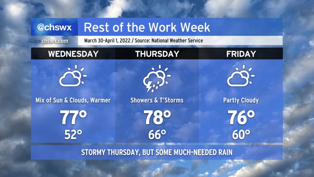
Thursday will turn stormy as a weakening squall line, which has produced a fair bit of severe weather across the Mid-South and central Gulf Coast states, gets into the area during the day Thursday. While widespread severe weather doesn’t look terribly likely thanks to a dearth of instability, the wind fields are such that thunderstorms might not need much in the way of vertical growth to generate some damaging straight-line winds. Indeed, outside of thunderstorms, gusts approaching 40 MPH will certainly be possible, especially on elevated surfaces such as bridges and overpasses. Low-level wind shear could briefly be supportive of a tornado, as well, but that risk is very low.
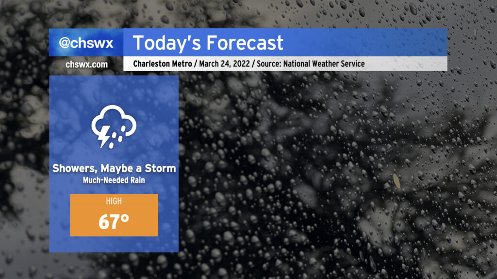
Expect showers possibly as early as 9-10am, with the best chance of rain and thunderstorms coming in the afternoon and early evening hours. Rain gear all day is a good call, but it’s not likely that any one spot will see rain all day, either.
Before rainfall arrives, temperatures will climb into the mid-to-upper 70s as warm air continues to pump into the area. Lows likely won’t drop below the mid-60s in most spots given the existing warm and moist airmass.
The good news is that this gets out of here relatively quickly, leaving nice and spring-like weather behind for Friday continuing into the Bridge Run on Saturday. The forecast for the run remains on track, with comfortable running temperatures and a light northeast breeze to maybe give you a little “oomph” on the Ravenel. (Lord knows I would need all the help I can get!)
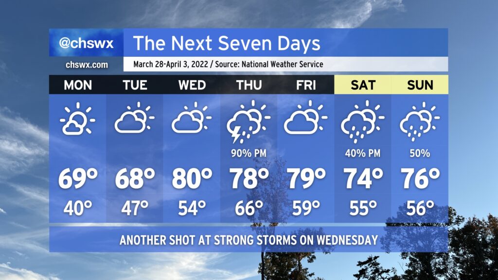
A warm front will lift north across the Lowcountry on Wednesday, putting an end to this stretch of below-normal temperatures and getting us in the warm sector of the next storm system which will affect the area Thursday before clearing the area Friday morning, yielding a docile finish to the work week.
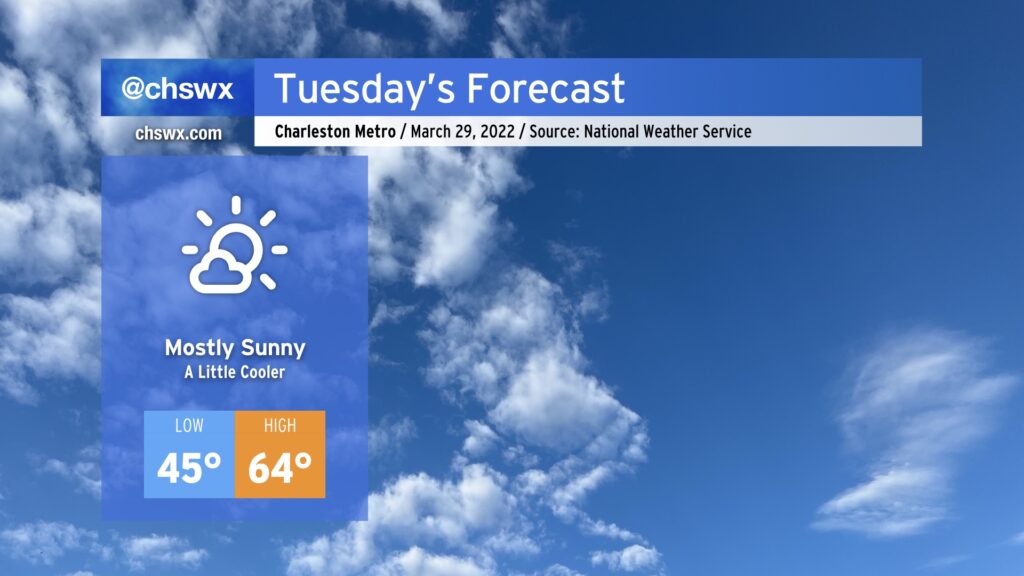
High pressure remains in control on Tuesday as it builds southward and down the East Coast. With the high centered to the north, winds will shift around more easterly and come in off the ocean. As a result, high temperatures will run cooler tomorrow thanks to the onshore flow as well as the loss of the downslope component to the wind that we get when it blows out of the northwest. Relative humidity values will be higher (though not uncomfortably so), making for much less fire danger for tomorrow and for the rest of the week.
Tuesday will be the last day of below-normal temperatures; a warm front will lift north of the area on Wednesday, sending temperatures back well into the 70s. Our next rain chance still looks timed for sometime Thursday afternoon and evening, all depending on the forward progress of a cold front. Severe weather appears quite unlikely at this juncture, but we’ll continue to keep an eye out for changes. Regardless of any severe storms, Thursday looks to be a rather windy day, with gusty winds continuing into Friday.
Bridge Runners, so far so good for the race, rain-wise, but we’ll be keeping a close eye on the potential for some storms at times this weekend. Stay tuned as the forecast gets further and further fine-tuning.
We’ve got a day or two more of chilly weather (for late March, anyway) before temperatures rise quickly on Wednesday as a storm system approaches the area. From there, a stalled front provides additional opportunities for rainfall over the weekend.
Our stretch of cool and fair weather continues into Monday at a minimum. There will be actual clouds in the sky on Monday, generally of the high variety as a little moisture squeezes out around the base of the trough that’s brought us this very chilly weekend. Temperatures will remain on the cool side, bottoming out in the 40s in the metro area and perhaps the mid-30s in more rural areas, prompting a Frost Advisory for Inland Berkeley County.
A warm front will approach the area on Tuesday, allowing for more cloud cover to develop. It’s not clear just how far north said front might get yet; the current forecast is for temperatures to once again top out in the upper 60s, but it’s possible that the afternoon could run a touch warmer if the front is able to make a little more headway.
Wednesday will offer one more rain-free day before the storm system gets into the area. By then, the warm front will have lifted north of us, with highs in the upper 70s to low 80s running in stark contrast to what we’ve experienced over the past few days.
The next appreciable rain chance arrives Thursday afternoon and evening with a cold front; rainfall looks likely with some rumbles of thunder, but the higher severe weather risk is displaced to the north with the better dynamics. We’ll get a break in the rain on Friday, but with the front stalling out to our southwest, shower and storm chances remain in the picture through the weekend. Temperatures, meanwhile, will remain a little above normal.
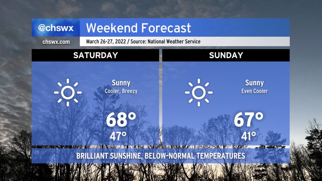
We’ve got a very nice weekend coming up, especially for those of you who prefer temperatures a little on the cooler side. A series of dry cold fronts will swing through, ushering in progressively cooler airmasses each day this weekend. Saturday will find temperatures starting in the mid-40s, headed to the upper 60s in the afternoon with some downslope flow and March sun angle helping to counteract the cool advection. Winds may turn gusty at times, with gusts to 30-40 MPH certainly possible, so be aware of this if you have any outdoor plans or need to drive a high-profile vehicle.
Another front swings through early Sunday, sending low temperatures into the low 40s before rebounding to the mid-to-upper 60s in the afternoon again under largely uninterrupted sunshine. It’ll be a little less windy on Sunday, but gusts still could reach 25-30 MPH at times.
Looking ahead, one more front comes through Monday before a warming trend begins across the area. Expect temperatures to rebound to the mid-70s by Tuesday and into the low 80s by Wednesday. Our next meaningful rain chance doesn’t show up in the forecast until Thursday. While the rain we got Wednesday and Thursday certainly helped, there’s still a good bit of ground to make up rain-wise to get us out of drought. That being said, I won’t complain about sunshine and comfortable temperatures, either. Enjoy!
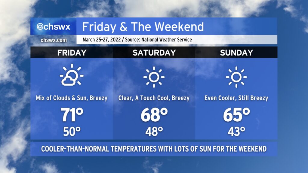
After some much needed rain Wednesday into Thursday, cooler and drier air builds back into the area for Friday and the weekend thanks to a series of cold fronts. Highs will top out in the low 70s on Friday with a mix of clouds and sun ahead of Saturday’s front, which will scour those clouds out and kick temperatures down a couple degrees, capping highs in the upper 60s to around 70°. Another reinforcing cold front gets through late Saturday into early Sunday, knocking temperatures back even further into the low 40s to start before only rebounding to the mid-60s in the afternoon despite full sunshine.
Through all of these frontal passages, expect gusty winds. Winds could gust upwards of 25-30 MPH on Friday, with gusts reaching or even exceeding 30 MPH on Saturday. Breezy conditions should also persist on Sunday as well. Keep this in mind if you have any outdoor activities planned, particularly those that involve tents or inflatables.
Fair weather persists into the upcoming work week, too, as a warming trend commences with highs approaching 80° by next Wednesday.
Much-needed rain will continue to fall for a good bit of today across the Charleston metro as a cold front slides eastward across the state. Said front will help to keep temperatures pretty steady-state throughout the day — we aren’t too far off from the NWS forecast high as of this writing (9am Thursday). No severe weather is expected, but we may yet hear a few more rumbles of thunder.
Rain will gradually taper off as we get into tonight, but showers may linger into early Friday morning. If you’ve got outdoor plans this evening, you may yet want to execute the indoor plan just to keep folks dry.