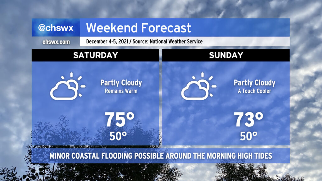
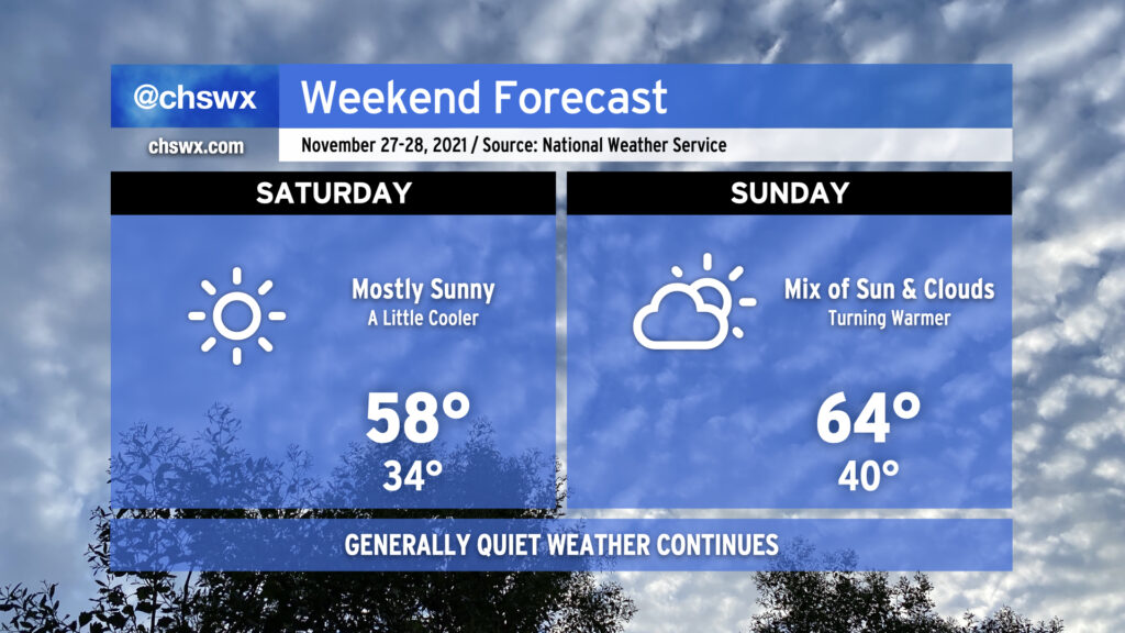
High pressure remains in control of our weather over the weekend, keeping partly cloudy skies in place and unseasonably warm temperatures in tow. We look to return to the mid-70s Saturday after starting out around 50°, weather that is more reminiscent of October than December. We keep this in place on Sunday, with highs perhaps coming in a couple degrees cooler as a cold front gets nearby (but not through the area, it looks like).
The only weather worry will be the risk for minor coastal flooding with the morning high tides on Saturday, Sunday, and possibly into Monday as the new moon at perigee brings us another round of king tides. High tide on Saturday morning arrives around 7:32am and on Sunday at 8:26am. Minor flooding can close a few roads around downtown Charleston, particularly near the Citadel and the City Market, but these disruptions should be easy to bypass. (It’ll be nothing like what we saw around this time last month, that’s for sure!) Keep an ear out for Coastal Flood Advisories from the National Weather Service and avoid roads covered in salt water as that’s nasty for your car.
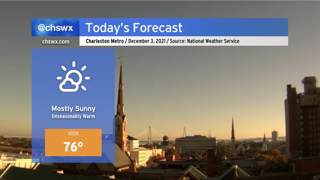
Mostly sunny skies and unseasonably warm temperatures will reign once again today as we remain under the influence of high pressure centered over the Gulf. Westerly winds with a touch of a downslope component will help temperatures warm some 8-10° above normal for early December. Warm weather fans, rejoice! Cool weather fans…I’m sorry.
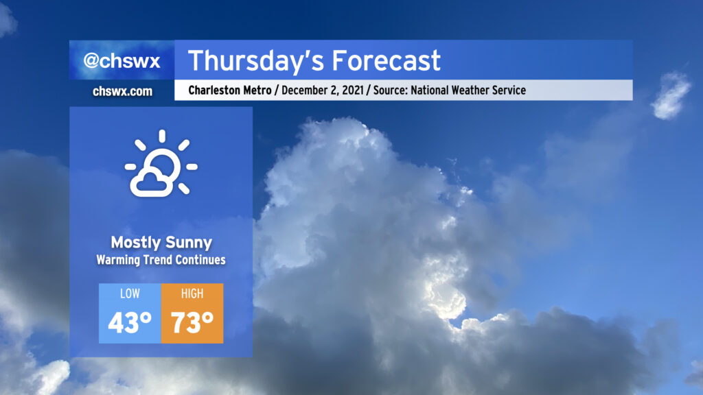
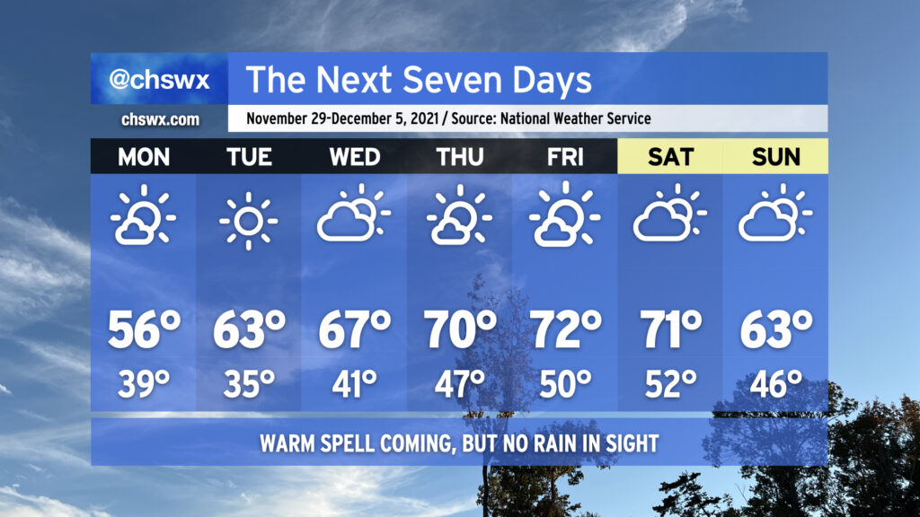
We hit 70° at the airport today for the first time since November 21, when we topped out at 75°. We’ll head north of 70° again on Thursday after starting the day in the low 40s in the metro (upper 30s further inland). Looks like we’ll top out in the low-to-mid 70s in the afternoon, with slightly cooler air at the immediate coast keeping temperatures in the upper 60s at the beaches. All in all, a fairly stellar December day (for our warm weather fans, anyway).
The 70s could continue all the way through next Monday before another frontal passage knocks temperatures back into the low 60s on Tuesday. Overall, the Climate Prediction Center outlook favors warmer-than-normal temperatures over the next couple weeks after what was a rather chilly November, tying 1940 for ninth-coolest November on record at the airport climate site with an average temperature of 54.1°. (Records began at the airport climate site in March of 1937.)
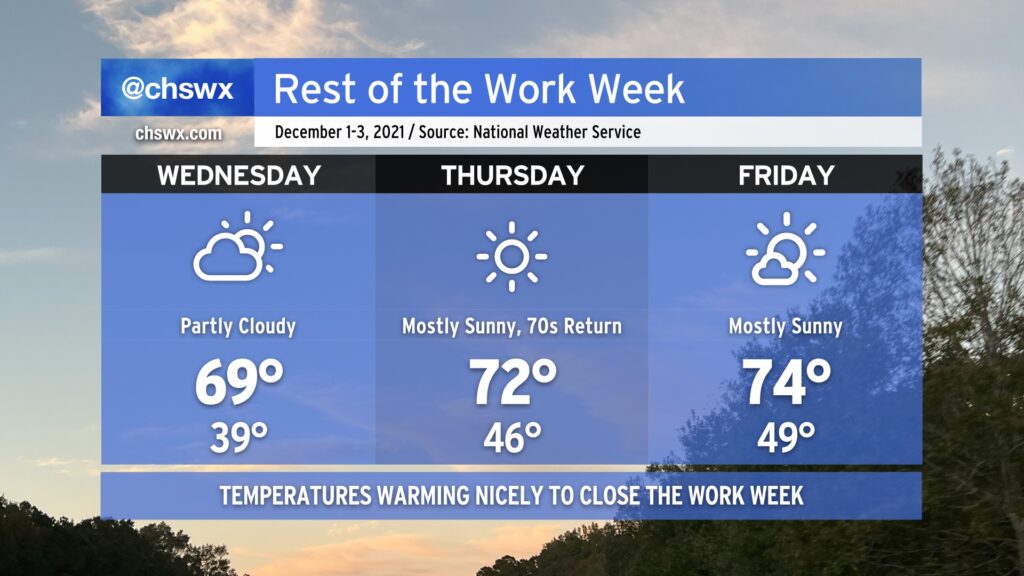
Meteorological winter begins tomorrow, running from December 1 through February 28, 2022. It sure won’t feel like it, though: temperatures will warm to near 70° on Wednesday, and then peek into the low to mid-70s on Thursday and Friday. We’ll have some cloud cover associated with a weak disturbance aloft Wednesday, but other than that, expect quite a bit of sunshine over the next few days.
The only weather concern looks to be a small risk for minor coastal flooding beginning with Friday morning’s high tide as we head toward the new moon phase. So far, the NWS forecast has that tide peaking just shy of 7’, which is the minor coastal flooding criteria. Peeking a little further down the road, guidance indicates that Saturday morning’s high tide may scrape that 7’ threshold as well. So far, though, it certainly does not appear to be a repeat of the last new moon, which brought us top-15 tides during the first week of November.
Finally, we bid adieu to the 2021 hurricane season, which was another extremely busy season in terms of named storms (21). For the second consecutive year, the primary storm name list was exhausted — but we did not have to crack open the supplemental list, at least. Once again, our luck has held here — aside from the quickly-developing Tropical Storm Danny and the nocturnal tornado outbreak associated with Tropical Storm Elsa, it was another rather quiet season for the Lowcountry, and for that I am grateful.
A freeze is expected overnight into Tuesday morning across much of the Lowcountry away from the immediate coast and near bodies of water. Make sure sensitive plants are covered and your pets are inside and warm!
Once we clear the chilly start, it’s going to turn out to be a really nice day across the area as highs head into the low 60s under brilliant, unfettered sunshine — a rare no weather worries day! Quiet weather continues for the next several days as a warming trend commences heading into the end of the week, in which the 70s will make a return.
The cherry on top? Tomorrow’s the last day of hurricane season — something we all can celebrate.
Below-normal temperatures and mostly sunny skies will continue through Tuesday to close out November, meteorological fall, and hurricane season as a weak front gets through overnight to reinforce the cooler airmass in place. Changes are coming, though — as the calendar turns to December and the beginning of meteorological winter, we’re gonna get warmer. The warming trend begins Wednesday, and we’ll look for temperatures in the low 70s for a spell Thursday-Saturday with generally partly cloudy to mostly sunny skies before another front gets through Sunday, sending temperatures a few degrees back below normal.
One thing that’s not forecasted? Rain, at least this week. Persistent dry air continues to keep any sort of rain to a bare minimum across the area with tonight’s frontal passage and will likely at least hamper rainfall development over land with Sunday’s passage, too. Peeking ahead in time, models suggest that the second week of December could see a little bit more in the way of precipitation, but we’ll need to see if that signal holds. For now, though, a good chunk of the Tri-County remains in abnormally dry conditions, with some of the northern fringes creeping into moderate drought. I expect this drought area to expand with Thursday’s Drought Monitor update.
For now, though, we will continue to savor the quiet weather. Have a great week ahead, and Happy Hanukkah to all of you who are celebrating!
We’ve got another chilly night ahead; temperatures could scrape freezing at a few spots by Saturday morning, so be sure you’ve got sensitive plants still protected and your pets have a warm place to be overnight.
Saturday will run a little cooler than today did in the wake of a cold front that came through earlier today. After starting the day around freezing (with wind chills making it feel about 3-5° colder), highs will top out in the upper 50s despite mostly sunny skies. Winds look to be generally light throughout the day with a shift in direction to the southwest late.
Sunday will feature more clouds but will also be warmer thanks to westerly winds ahead of another weak cold front poised to come through early Monday morning. Temperatures will rebound to the mid-60s in the afternoon after starting around 40°, making for a seasonably comfortable late November day in the Lowcountry.
A Freeze Warning is in effect overnight as a killing freeze is likely going to end the growing season across the Lowcountry. While places near bodies of water such as Lake Moultrie and coastal areas should remain above freezing, the vast majority of us look to experience at least some duration of freezing temperatures, with the longest-duration freeze well inland. Protect plants, pets, pipes, and people tonight!
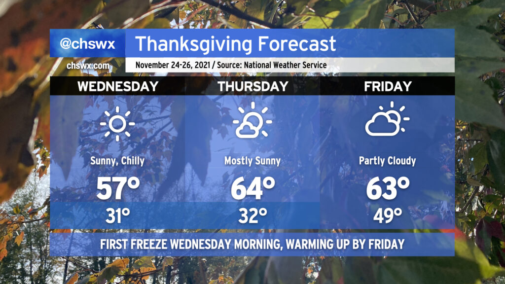
Temperatures will warm only to the mid-50s on Wednesday — perhaps a degree or two warmer than we saw today — but still well below normal for this point in November. We’ll dip back toward and likely below freezing in many spots again on Thanksgiving morning before high pressure slips offshore and return flow develops, helping temperatures to warm into the mid-60s with mostly sunny skies for much of the day. Friday morning will be considerably warmer ahead of a cold front that’ll swing through during the day. Said front will enhance cloud cover and help keep highs back into the low-to-mid 60s once again, a few clicks below normal but certainly not to the degree we experienced today and will experience again on Wednesday.
Travel safely (if you’re headed anywhere) and have a wonderful Thanksgiving holiday!
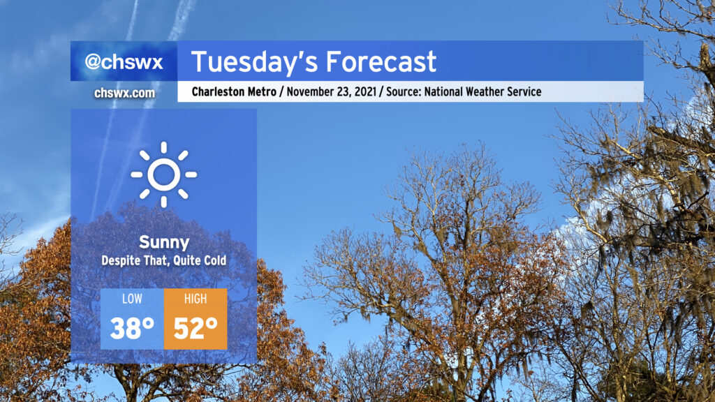
Sweater alert for Tuesday! We’ll start the day a little breezy and much cooler as a polar airmass takes residence in our neck of the woods. Air temperatures should bottom out in the mid to upper 30s away from the locally warmer coastline, but factor in the wind and it’ll feel closer to 30-32°. We’ll see predominantly sunny conditions throughout the day with just a few passing clouds at times in the afternoon; despite this, temperatures look to go no higher than the low 50s. Make sure your pets have a warm place to be tonight.
As we get into Tuesday night and Wednesday morning, winds will come down and allow radiational cooling to develop, which should be enough to get us our first freeze of the year in many spots (with widespread frost elsewhere). Lows look to bottom out from the mid-30s away from the immediate coast to possibly some upper 20s well inland. (Areas around Lake Moultrie should stay a touch warmer thanks to the influence from the warmer waters.) You’ll definitely want to make sure pets and plants have a warm place to be.
After one more frosty morning on Thanksgiving, temperatures will moderate back into the 60s in the afternoon, where we’ll stay for a couple days before a reinforcing shot of cooler air arrives in time for the weekend.
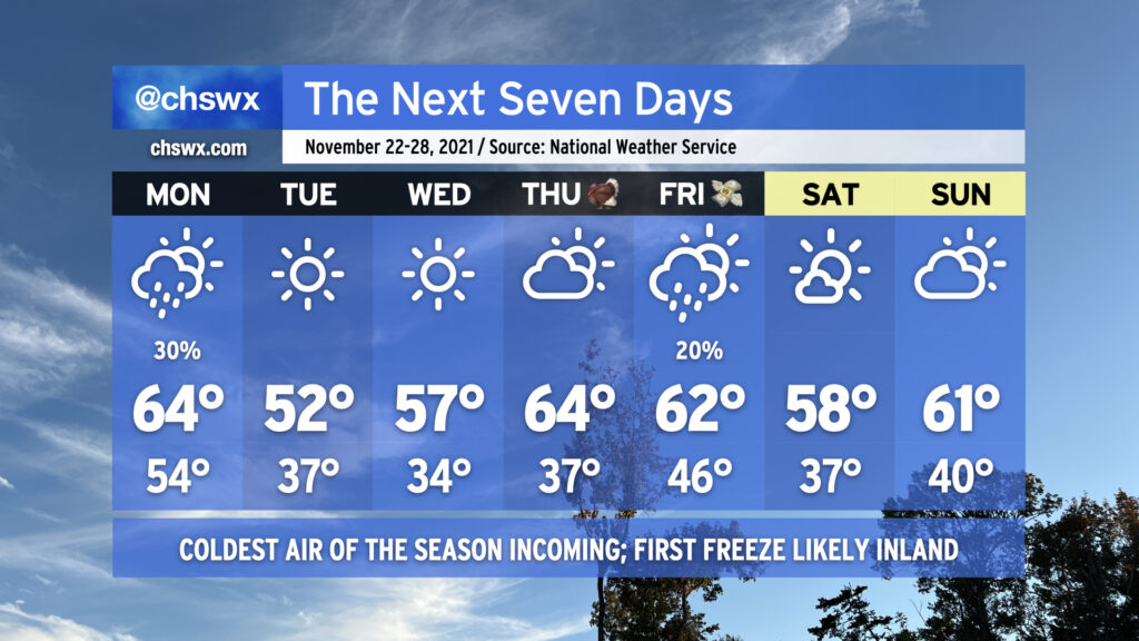
Today’s high of 73° could quite possibly be the last 70s we experience for the rest of November as a prolonged spell of below-normal temperatures is in the cards for the upcoming week. We start the abbreviated work week on a somewhat showery note as a cold front approaches the area during the day Monday. Rain chances tend to diminish as the front gets closer to the coast, but a few of you could see a few hundredths of an inch of rain during the day. The front gets through later Monday, and by Monday evening, cold air will rush into the area from the north as high pressure builds in.
We’ll start Tuesday in the mid-30s away from the locally cooler coastline, and could flirt with freezing conditions in some pockets well inland. Factor in the breezy north wind, and it’ll feel closer to the upper 20s in the morning. Highs will struggle to the low 50s in the afternoon with that persistent north wind continuing to make it feel a little cooler.
Calming winds and clear skies will provide excellent conditions for radiational cooling overnight Tuesday into Wednesday, and it appears likely that much of the area away from the coast will see its first freeze of the season with frost developing in other locations. Be ready to cover or bring in sensitive vegetation and make sure your pets have a warm place to be! Highs on Wednesday will run a little warmer than Tuesday, but still don’t look to crack 60°.
After another chilly start on Thanksgiving morning, temperatures will warm nicely into the mid-60s under partly cloudy skies. We could see a few showers on Black Friday as another cold front approaches the area with a reinforcing round of cooler air for the weekend, which looks to remain rain-free as of right now.