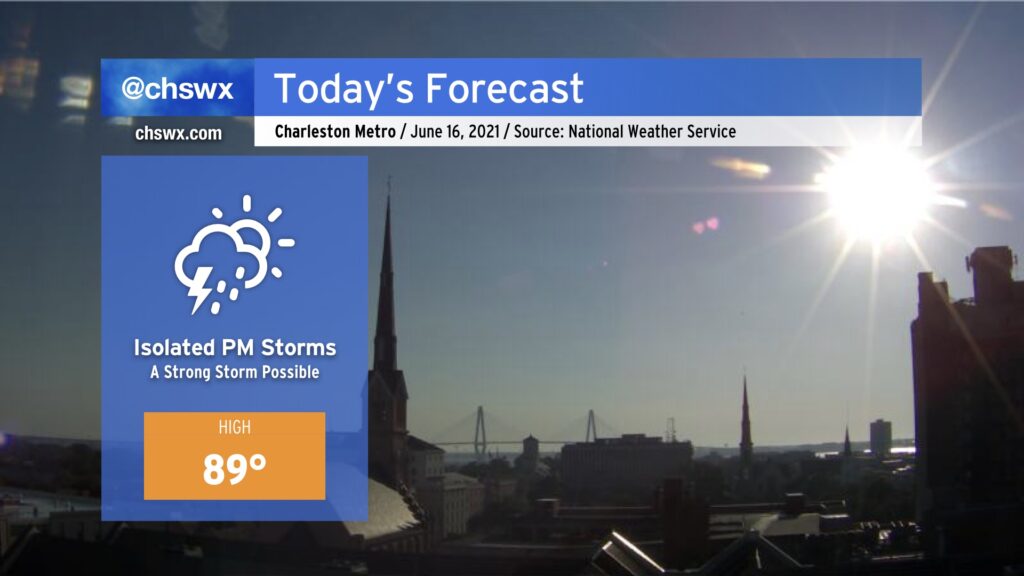
While the cold front that triggered last night’s deluge has slipped south of the area, it has stalled out nearby. With a little bit of help from some upper-level dynamics, we should see some isolated thunderstorms in the metro area this afternoon. A damaging wind or large hail episode is possible for a few of you, so stay alert across the area this afternoon. With that in mind, the severe threat certainly looks more isolated than we saw yesterday.
Highs top out near 90°; with a little less humidity behind the front, it won’t feel quite as swampy outside.
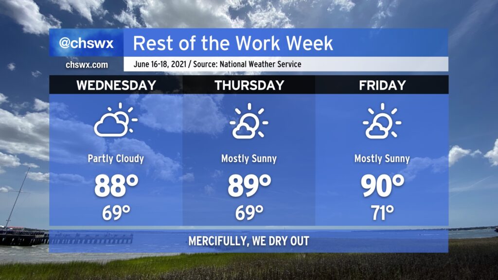
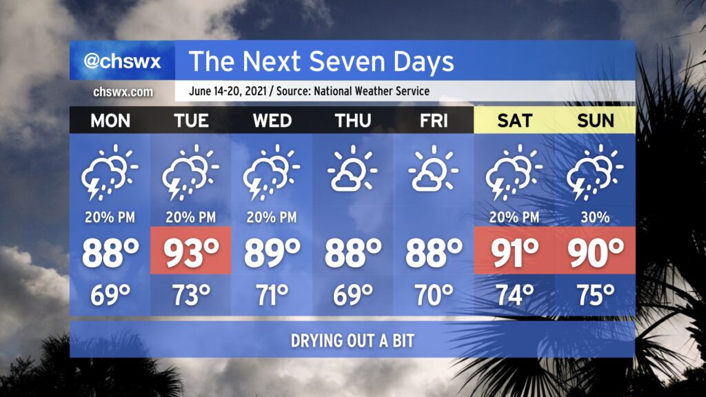
After today, we look to stay rain-free through Saturday with warm temperatures and low humidity by June standards.
After another night of heavy rain and flooding (with some hail and wind damage mixed in), we thankfully get a few days to dry out as drier high pressure builds south across the area overnight Tuesday into Wednesday. Temperatures will run a degree or two either side of normal for the rest of the work week. Humidity will be rather low for this time of year, and so heat indices will not run too much warmer than the air temperature. Still, “normal” for mid-June means upper 80s to low 90s, so it won’t exactly be cool. But any time we can get a drier heat for a few days during a Charleston summer, we will take it.
More importantly, we will stay rain-free for several days. It’s hard to believe that we were talking about a developing drought just two weeks ago, but here we are after a couple extraordinarily soggy days being extremely pleased to see the rain take a quick break. We look to stay dry through Saturday before tropical moisture once again infiltrates the area beginning Sunday.
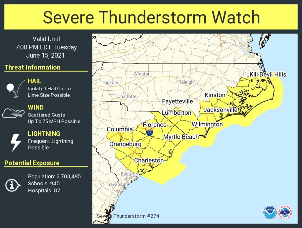
6:50 PM update: The Severe Thunderstorm Watch has been extended until 9PM. The risk for severe weather continues in the Lowcountry, particularly with a severe thunderstorm moving through eastern Orangeburg County, approaching Berkeley County.
A Severe Thunderstorm Watch is now in effect for the Charleston metro area (including Berkeley, Charleston, and Dorchester counties) until 7PM. Damaging wind gusts and large hail will be the primary concerns for any storms that form. Stay alert to possible severe thunderstorm warnings this afternoon and evening, and be ready for quickly changing conditions.
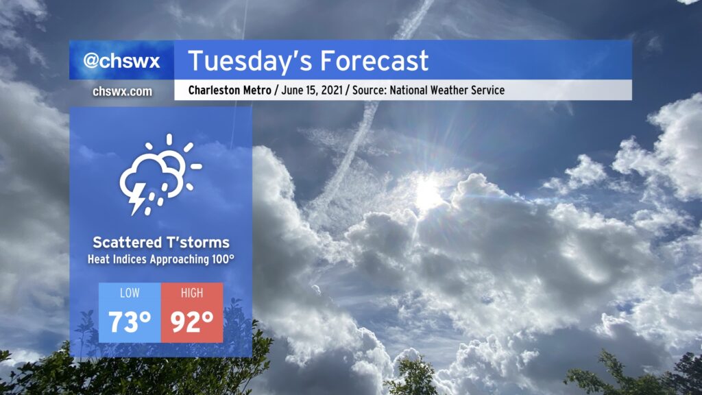
Typical June weather continues for Tuesday. Temperatures will head up into the low 90s in the afternoon as westerly winds keep the seabreeze pinned to the coast. We’ll want to keep an eye on an upper-level disturbance as it swings through; this could help a few storms to get going in the afternoon, especially if the seabreeze can make some inland progress. There will be enough instability to support storms if enough lift is realized, and dry air in the mid-levels could portend a risk for isolated damaging wind gusts. So, we’ll keep an eye on this, but it is more likely than not we get through Tuesday rain-free in a vast majority of spots — good news as we dry out from this past weekend’s deluge.
After a very soggy weekend, we will get the opportunity to dry out a bit as the deep moisture plume which has been in place for the last few days finally gets shunted away from the area. This week is going to be pretty standard June fare: highs in the upper 80s to low 90s with a chance of isolated afternoon thunderstorms will be common. Thursday and Friday will be a touch cooler and drier in the wake of another front moving south of the area, and this could put the kibosh on even slight chances of afternoon showers and storms (though you can never totally rule it out at this point in the year). Expect slight shower and storm chances to return for the weekend as a little more moisture gets fed our direction from the Gulf.
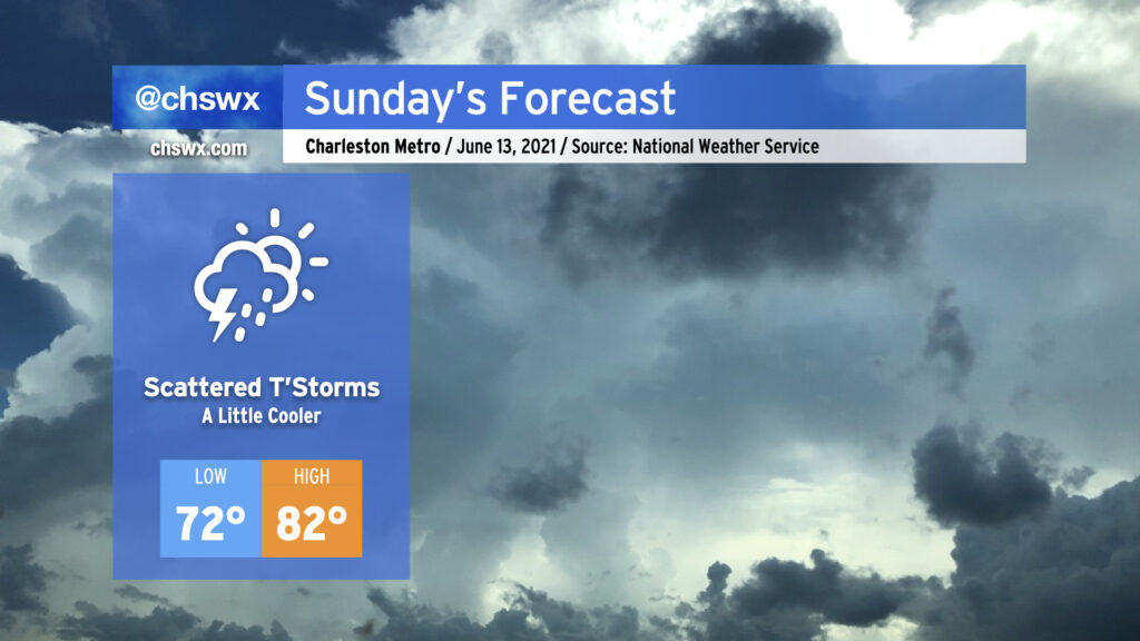
After what ended up being a raucous Saturday evening (for all the wrong reasons), we’ll start Sunday on the cool side of a frontal boundary that will stall out and dissipate midway between Savannah and Jacksonville. Low pressure will develop along the front and move away, keeping us in northeast to easterly flow. The rich atmospheric moisture that helped contribute to our flooding issues today will remain in place for Sunday. Guidance hints on the potential for some coastal rainfall in the morning as low pressure develops offshore and moves away, followed by scattered afternoon storms with the inland-progressing seabreeze (though this evening’s models are blessedly trending drier). With persistent weak storm motions expected, we’ll have to keep an eye on any downpours that can get going for an isolated flooding threat, particularly if they fire in the West Ashley to Downtown corridor along Highway 17, where 3-5″ of rain fell this evening.
The post-frontal airmass and onshore wind will keep things a touch on the cool side for June, with expected highs in the low-to-mid 80s. Unfortunately, this doesn’t come with much of a dip in dewpoints, so we’ll still be on the muggy side of comfortable.
Let’s hope the drier trends in guidance continue! (Side note: It’s amazing how fast we go from “we need the rain” to “make it stop” in summertime…)
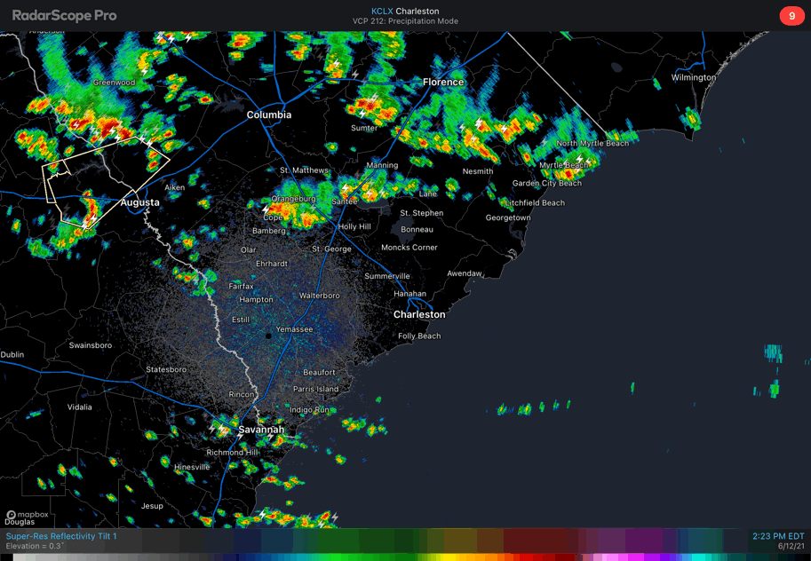
We in #chswx continue to watch for the potential for heavy rain with thunderstorms later this afternoon into tonight. Radar at 3PM begins to show some showers and storms sinking into the northern part of the Tri-County, including St. George and the Lake Moultrie region. Further north, we see a line of intensifying thunderstorms stretching from Horry County through Sumter and points northwest.
It has been quiet so far in the Tri-County area. A stubborn low cloud deck kept temperatures at or below 80° through 1-2 PM before it shifted south and began to mix out. Temperatures have recovered well with just a couple hours sunshine; we’re now at 86° at the airport as of 3PM.
Outflow boundaries emanating from the storms to the north should help to trigger some additional thunderstorm activity closer to home in the next couple hours, especially as surface temperatures continue to warm. The front, which is currently sagging through the upper Piedmont and coastal plain of North Carolina, is continuing its southward motion. Meanwhile, upper-level winds are relatively light and blowing parallel to the outflow and frontal boundaries. This is an indication that slow-moving, potentially back-building and training thunderstorms will be possible. Lift from the front should keep storms going well after dark, too.
High-resolution ensemble guidance paints very high probabilities of 1-3” of rain in 3 hours across the Tri-County area, especially north of 17-A. Obviously, we’ll need to see how things evolve with the finer details over the next few hours, but this is certainly an area to watch given strong model support for heavy rain here.
This evening’s trends will need to be watched closely for downtown Charleston as well. High tide will be coming up around 11PM in Charleston Harbor, and it is conceivable that storms could still be going around this time. Even a heavy rain an hour or two ahead of high tide can cause significant problems for several hours afterward as the tide impedes drainage. In other words, we don’t necessarily need rain and tides to line up perfectly for problems downtown.
Keep an eye on weather alerts this afternoon into tonight. If you have a car in a vulnerable location, be ready to get it to higher ground quickly if the need arises.
Updates will be largely on Twitter, so be sure to follow me over there for the latest.
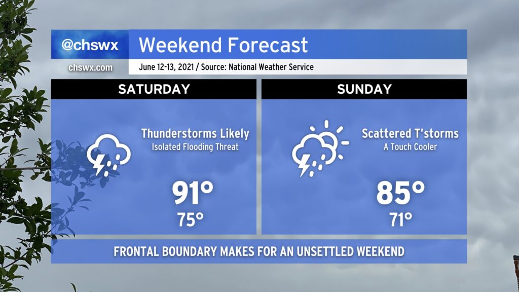
We will get off to an unsettled start to the weekend as a frontal boundary sags south into the area during the day on Saturday. Ahead of the front, expect highs to top out in the low 90s before numerous showers and thunderstorms develop across the area. Chances are pretty good that you’ll see at least a little rain at some point tomorrow. With plenty of available moisture to wring out, though, it is conceivable that flooding may be a concern tomorrow within the strongest storms. While severe weather looks unlikely, all storms are dangerous due to the lightning they produce. When thunder roars, go indoors!
It’s expected that the front will pass through and stall out to our south by Sunday. Temperatures will run a little “cooler” with highs topping out in the mid-80s, but scattered showers and thunderstorms should still develop in the afternoon. How Sunday ultimately evolves will depend on what goes on during the day Saturday, so keep an eye out for forecast adjustments.