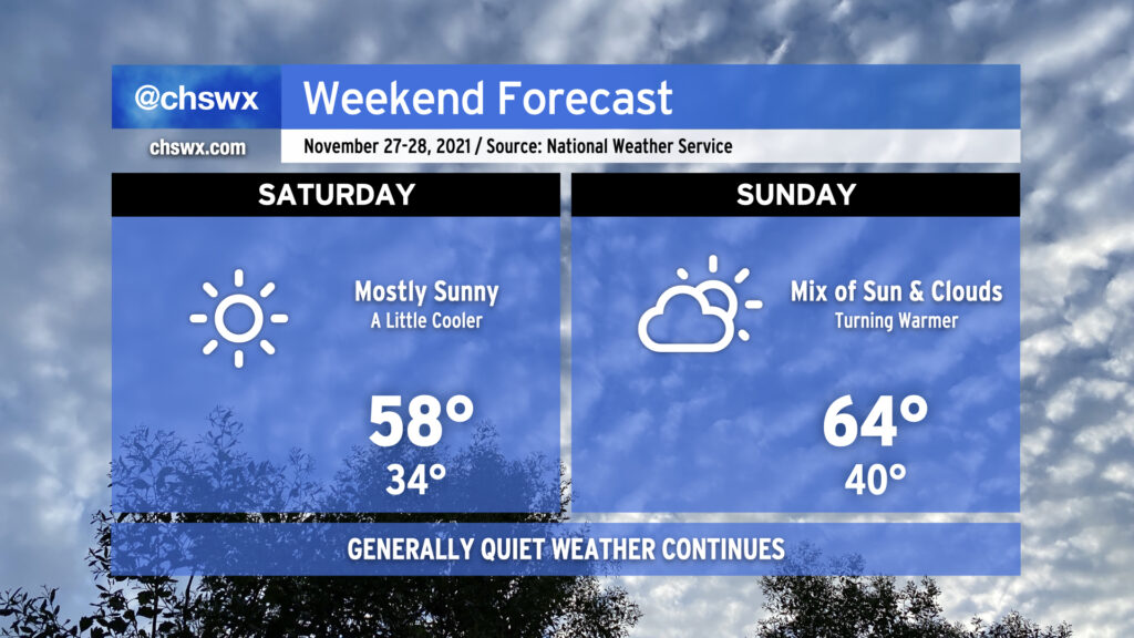
We’ve got another chilly night ahead; temperatures could scrape freezing at a few spots by Saturday morning, so be sure you’ve got sensitive plants still protected and your pets have a warm place to be overnight.
Saturday will run a little cooler than today did in the wake of a cold front that came through earlier today. After starting the day around freezing (with wind chills making it feel about 3-5° colder), highs will top out in the upper 50s despite mostly sunny skies. Winds look to be generally light throughout the day with a shift in direction to the southwest late.
Sunday will feature more clouds but will also be warmer thanks to westerly winds ahead of another weak cold front poised to come through early Monday morning. Temperatures will rebound to the mid-60s in the afternoon after starting around 40°, making for a seasonably comfortable late November day in the Lowcountry.
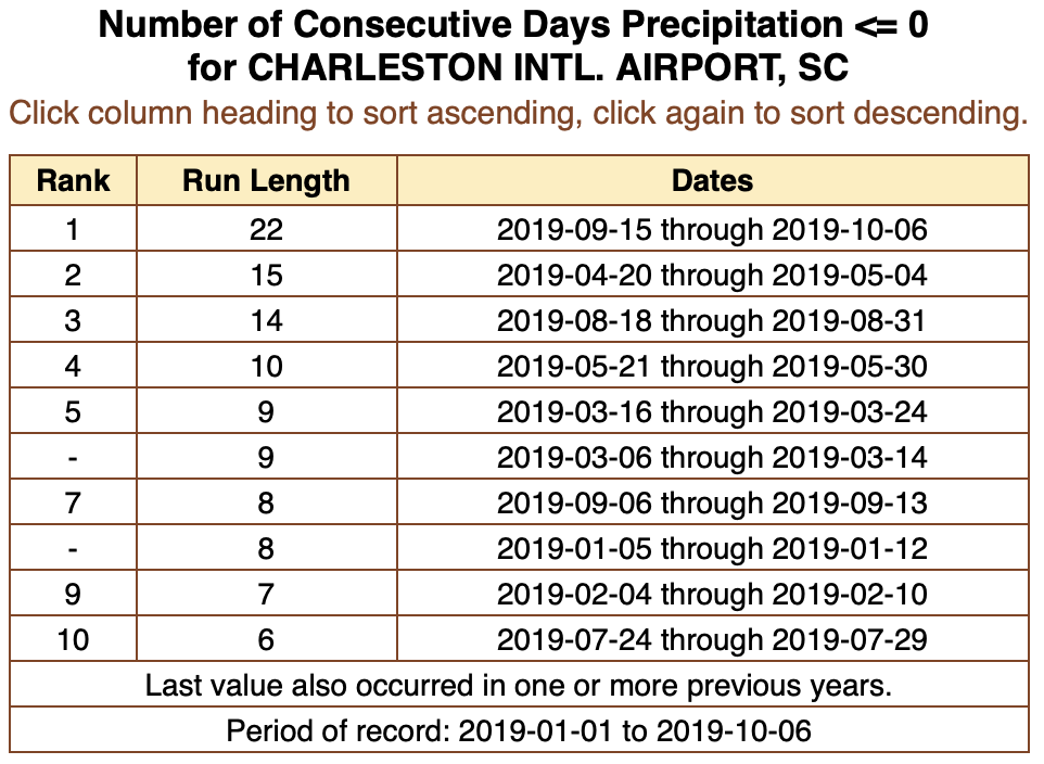
For the first time since September 14, the airport has recorded measurable rainfall. (Traces of rain were recorded September 15, September 30, October 5, and October 6.) As of this writing, a whole one-hundredth of an inch has been recorded at the airport today. (Hey, it’s something.)
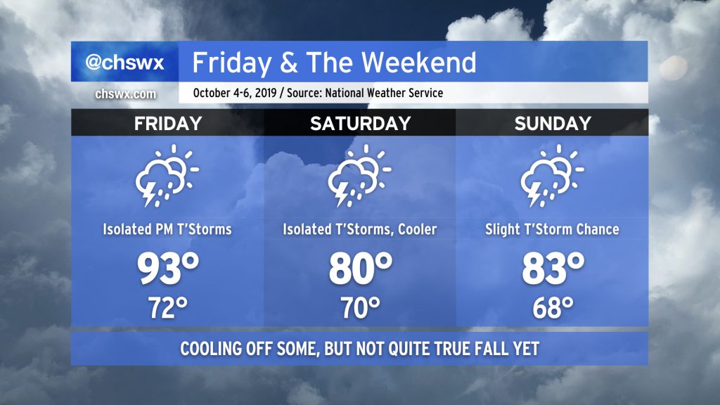
We’ve just got one more sweltering Augtober day left before a backdoor cold front swings through the area, cooling us off for the weekend. This will come with a little bit of much-needed rain, too, but don’t expect a washout. After that, another frontal system will usher in a little bit more Fall weather.
Our abnormally warm and dry September will roll into the first few days of October as strong high pressure aloft remains anchored over the southeast U.S.
Changes are coming, though, and I suspect many of you will be OK with them.
It’s been a while since I’ve been able to say this, but here goes:
The record high of 98°, set in 1953, is safe today.
Temperatures will only top out in the mid-90s before thunderstorms — yes, thunderstorms with actual rain — start to develop by mid-afternoon. A few of these thunderstorms may be on the strong side, though.
Since the Good Friday severe weather event, weather has been largely quiet in the Charleston metro area. Even a front that swung through this past Friday wasn’t able to eke out any rain across the Lowcountry. As a ridge of upper-level high pressure continues to be in control, we have more warm, dry days ahead.
A period of unsettled weather begins today and will last through the weekend. No washouts in store, but be ready for scattered showers and even some thunderstorms. With a lot going on outside this weekend, you’ll want to stay weather-aware.
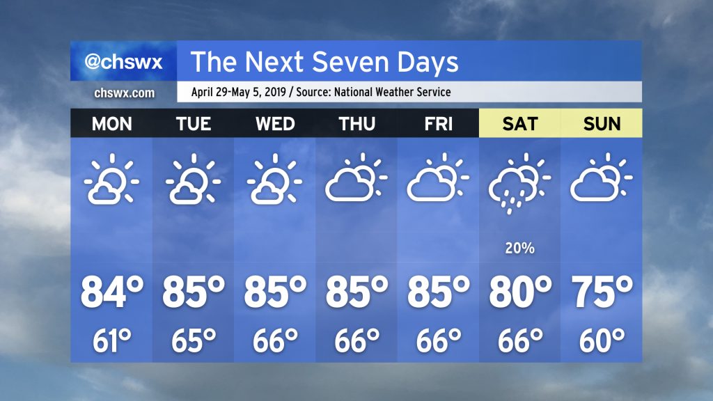
A nearly flawless Spring Break week (weather-wise, anyway…) will close with a nice warmup as temperatures surge into the upper 70s and perhaps the 80s to end March. Changes are coming, though — the transitional season of Spring is not through with us yet.
Weather-wise, we have a pretty tranquil week ahead (save for maybe a shower or two overnight Wednesday into Thursday morning). We’ll just need to keep an eye on tides with a full moon in perigee (“Supermoon!”) this week.