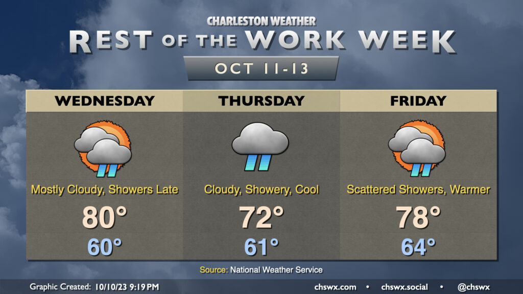
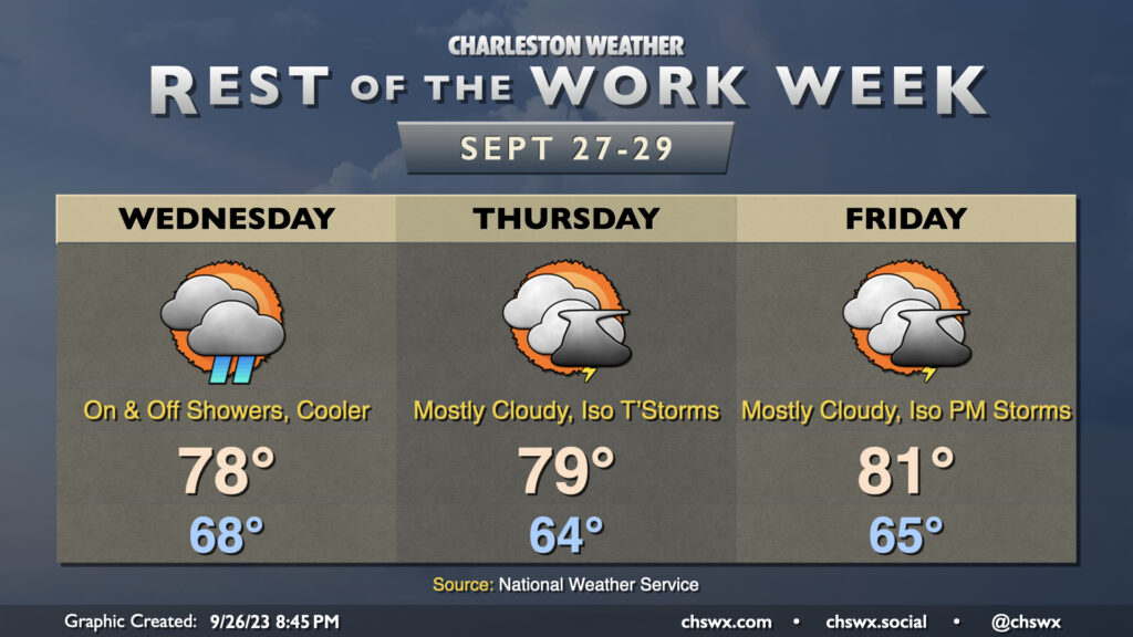
Increasing moisture will proliferate across the area during the day Wednesday as high pressure continues to give way to a disturbance that’ll move across the Gulf. Much of the day should be dry as it takes some time for the remaining dry air to scour out, but once that does, expect showers to begin at some point Wednesday evening, peaking overnight Wednesday into Thursday morning. Thursday’s going to be kind of a chilly and raw day as high pressure wedges in from the north, socking us in with cloud cover and occasional showers. Expect highs to top out in the low 70s at best. A warm front lifts north of the area later on Friday, and that’ll send temperatures back up a bit. We could see some rumbles of thunder alongside more scattered showers, so keep the rain gear handy.
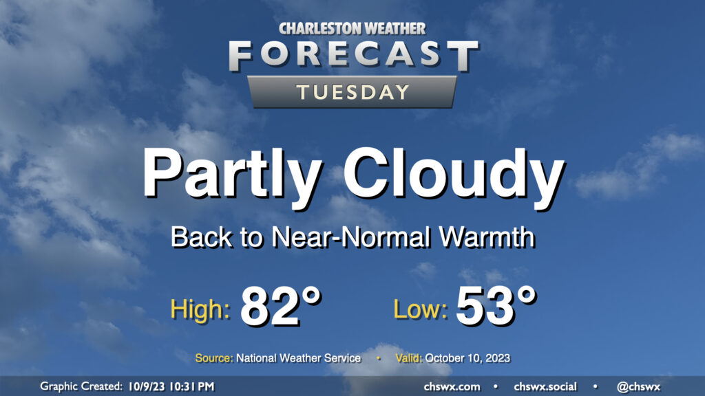
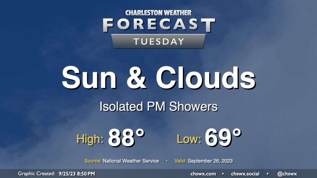
Clouds and temperatures will be on the increase for Tuesday as moisture begins to move back into the area. We start Tuesday in the low 50s before temperatures warm reasonably quickly into the low 80s by early afternoon. We should get plenty of sun for much of the day, though cloud cover will be thickening by evening.
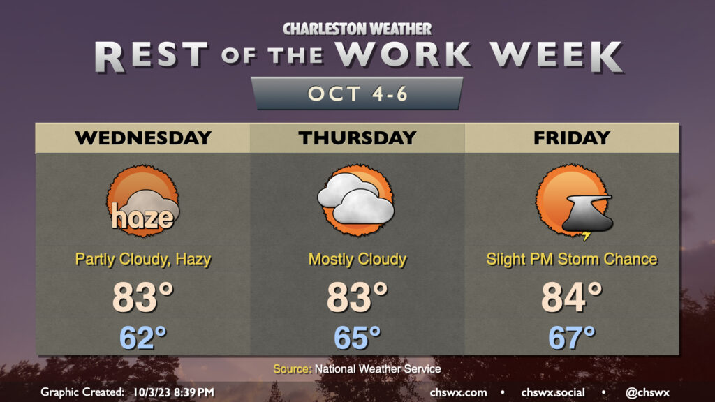
The past couple days have been marred somewhat by wildfire smoke moving southwest from Canada, and it looks like that may persist at least into parts of Wednesday as well. There could be some air quality impacts, so if you are sensitive to particulate matter, you may want to spend a little more time inside. (Masks such as N95s will help here, too!) Smoke aside, the weather is otherwise quiet; lows bottom out in the low 60s once again and head into the low 80s in the afternoon under partly cloudy skies. We’ll also need to keep an eye on the midday high tide for one more round of minor coastal flooding, but that should do it for this stretch of coastal flooding events with some pattern changes in the offing.
We should see improvements with the smoke heading into Thursday, but cloud cover will begin to creep up as a little more moisture starts to work into the area. We should stay rain-free, though a shower might not be totally out of bounds. Highs once again top out in the low-to-mid-80s.
Warmth peaks Friday as ever-so-slightly higher dewpoint air continues to move in. We start the day in the mid-to-upper 60s and top out in the mid-80s with a chance of a shower or thunderstorm or two in the afternoon ahead of an approaching cold front. Said front moves by Saturday, and by Sunday, temperatures are very fall-like.
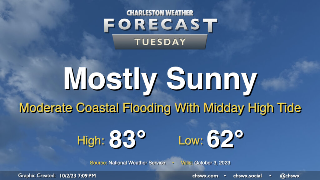
Our solid start to October continues on Tuesday, with mostly sunny skies and comfortable temperatures continuing with high pressure in control. The only potential issue will be the risk for moderate coastal flooding with high tide just before noon; there could be travel disruptions as some of y’all look to grab lunch, so that’ll be something to keep an eye on. Otherwise, though, it’ll be another very nice day.
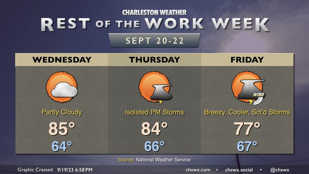
High pressure wedging into the area will keep us on the somewhat cool and cloudy side for the next few days, with shower chances peaking Wednesday before tapering off for Thursday and Friday (though cloud cover and the occasional shower or storm will linger). Highs on Wednesday and Thursday shouldn’t get out of the upper 70s, while we may trend a little warmer Friday as some drier air begins to work in and a little more sunshine becomes possible.
We have one more day of the upper 80s in store before changes arrive in the form of a wedge of high pressure building in from the northeast for the rest of the week. Tuesday starts in the upper 60s inland to perhaps mid-to-upper 70s closer to the coast. Highs then head into the upper 80s once more, and with dewpoints edging up into the upper 60s, it’ll feel closer to 90° or so. From there, clouds will increase and a few showers should break out in the afternoon, though nothing over-the-top is really expected. There may be a rumble of thunder late, but overall, not expecting much in the way of lightning. Shower chances continue into the evening, and really for much of the rest of the work week from there.
The rest of the work week will turn somewhat unsettled as a coastal low spins up later this week into the weekend. Wednesday still looks good, though, with seasonable warmth in the mid-80s under partly cloudy skies in the afternoon. We could see a couple isolated thunderstorms pop on Thursday as onshore flow becomes a little more pronounced as a coastal trough sharpens nearby. Temperatures will start in the mid-60s and top out in the mid-80s in the afternoon.
Friday is when we should start to see winds begin to kick up at the coast as the pressure gradient between low pressure developing offshore and high pressure over New England begins to tighten. The stronger onshore flow as well as a scattering of showers and a few thunderstorms will keep highs in the mid-to-upper 70s. Yes, there is still a low chance that this system could attain some tropical characteristics, but it’s not something I’d be overly concerned with. Could make for a less-than-ideal weekend at the beaches, though. Stay tuned to forecast updates as we get closer to the weekend.
We have another pretty day ahead for Tuesday (weather-wise, anyway). Temperatures start out quite nicely, with much of the metro starting in the low 60s. Some spots further inland could bottom out in the upper 50s, while places closer to the coast will generally feel warmer lows in the upper 60s. Temperatures head to the mid-80s in the afternoon. Dewpoints will mix down to the mid-50s except perhaps at the immediate coast, sending relative humidity values south of 40% once more. Overall, no complaints in the weather department.
Shower and thunderstorm chances — as well as temperatures — peak on Wednesday ahead of a cold front approaching the area. We’ll start the day in the low 70s with highs heading into the upper 80s in the afternoon before thunderstorms erupt generally along the seabreeze. A few thunderstorms could produce some strong wind gusts, with heavy rain and frequent lightning the more widespread concerns. The front should stall out to our west for the balance of the day before making its move through the area overnight Wednesday.
The airmass change behind the front will be somewhat slow at first. We’ll certainly see slightly lower dewpoints Thursday with air temperatures topping out a few degrees cooler as well, generally in the mid-80s. However, there should be enough low-level moisture to allow for a few popup showers and storms in the afternoon, so be ready for the potential to dodge a storm or two.
The airmass change picks up steam later Thursday into Friday, which looks positively brilliant. Expect lows in the mid-60s Friday to be followed by highs in the low 80s in the afternoon under nearly unfettered sunshine. Dewpoints will fall into the low-to-mid-50s during the day, providing a comfortably warm feel to the air. We’ll keep this going into the weekend, too, with lows bottoming out near 60° on Saturday. (Might even record a few upper 50s in some spots!) Fall is indeed coming, but these transitional seasons can be a little frustrating at times as the weather see-saws back and forth. (Hence “transitional season.”
Tuesday’s forecast will once again feature a seasonably warm and humid airmass that’ll give rise to some showers and thunderstorms in the afternoon, generally along and ahead of the seabreeze. We start the day in the low-to-mid-70s. Some fog may be around as we start the day, so be ready for possible visibility reductions particularly as you get further inland. Highs top out around 90° in the afternoon before a few storms fire, which will cool things off for some of us. A couple strong storms are possible, but don’t expect a widespread severe weather issue.