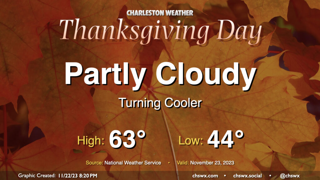
One front has come through as of this writing Wednesday evening, with another front hot on its heels to pass through overnight into early Thanksgiving morning. This second front is going to bring in quite the cooldown for the next few days, especially as we get into Friday and Saturday, but Thanksgiving will certainly illustrate the contrast from the past few days: expect lows in the mid-40s to warm to just about 60° in the afternoon, which is just a hair warmer than Wednesday’s morning low! We’ll have plenty of sunshine, though, with no weather worries for the holiday.
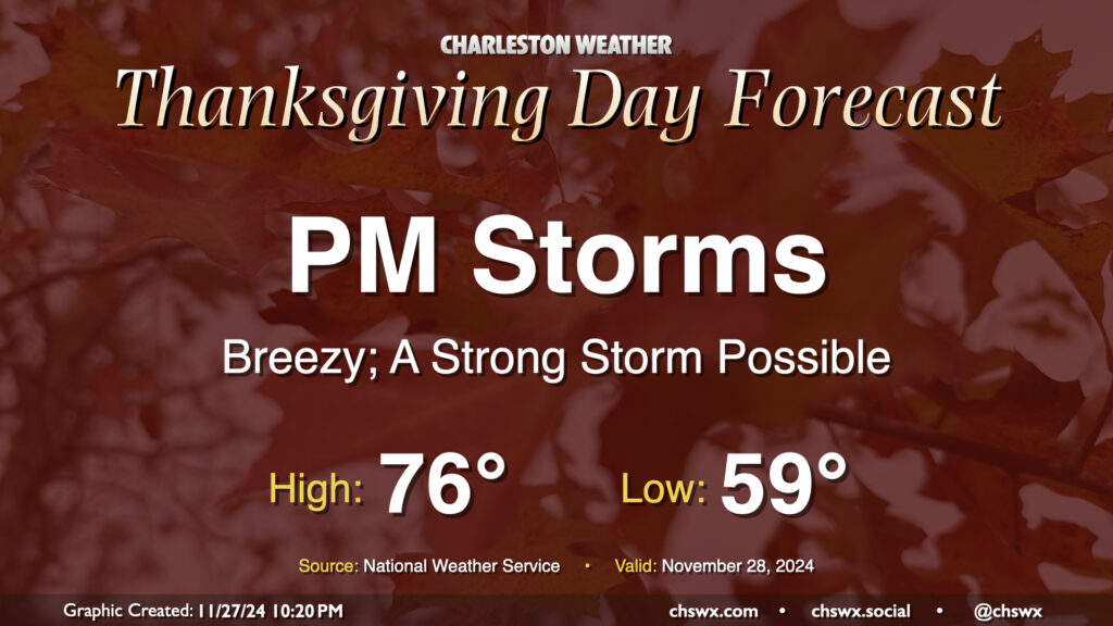
We won’t have the best weather on Thanksgiving Day, unfortunately, as a strong cold front moves through the area. It’ll bring with it some gusty winds and eventually some showers and even a few thunderstorms as we get into the afternoon and evening hours. It’ll be a warm and humid day by late November standards, with lows in the upper 50s to around 60° yielding to the mid-70s in the afternoon. This could help provide sufficient instability within a fairly well-sheared airmass to produce a strong to severe thunderstorm or two as the front approaches, with damaging straight-line wind gusts the main concern. The timing for storms appears to be generally between about 2pm-9pm, progressing west-to-east. It’s possible not everyone will see a storm or even any rain, but we just need to keep an eye on the storms that do fire to make sure they behave.
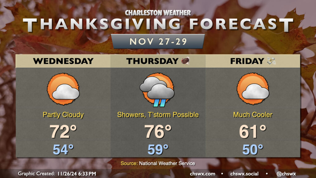
We have quite the weather rollercoaster in store for the Thanksgiving 2024 holiday period. First, Wednesday will run much warmer than normal despite a frontal passage Tuesday night; expect lows in the mid-50s to yield to highs in the low 70s under partly cloudy skies as the front lingers just to the south. We’ll stay rain-free on Wednesday, though showers will be approaching from the west with another, stronger frontal system.
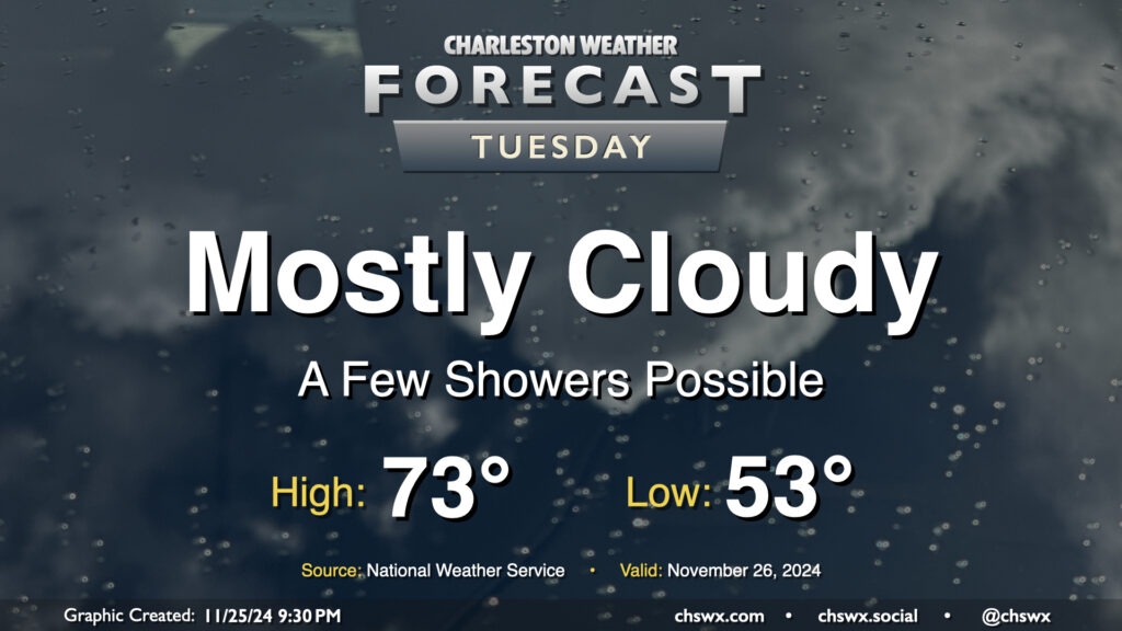
Tuesday begins an occasionally unsettled period of weather that’ll last through early Black Friday as a series of fronts moves through the area. The first one, poised to move through Tuesday evening, won’t be terribly strong; it’ll kick up some cloud cover and maybe a few showers as well out ahead of it, but it won’t really affect the airmass all that much. We’ll start Tuesday in the low 50s, warming to the low to mid-70s in the afternoon. Dewpoints will surge back into the 60s for a brief period, but those will begin to fall by evening as the front moves by.
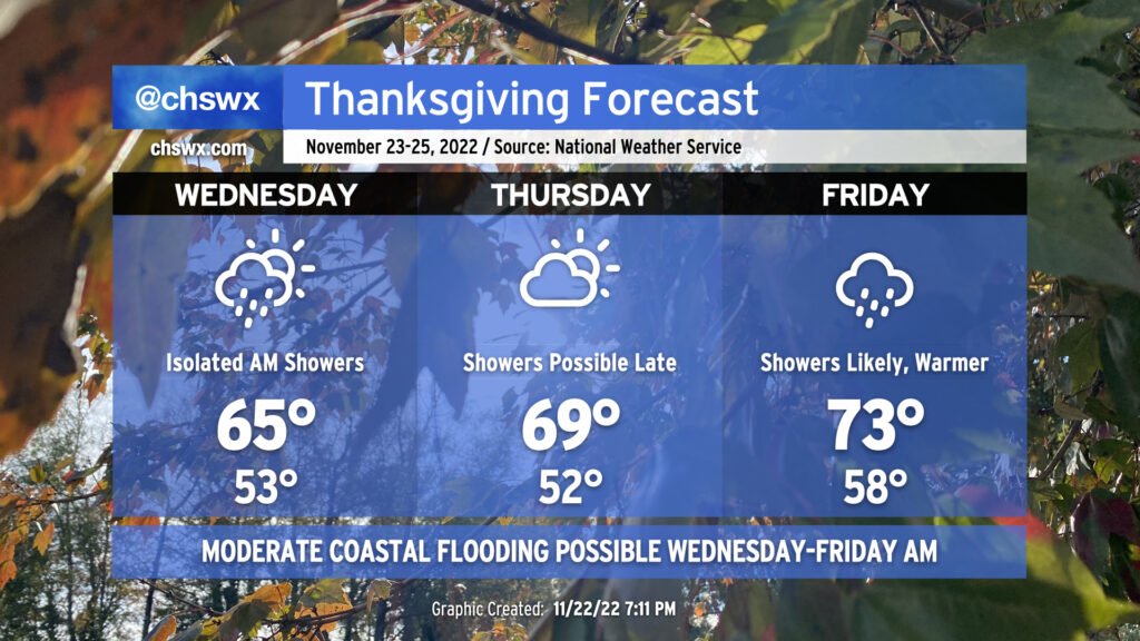
After some much-needed rain Tuesday and Wednesday, we get a day to dry out on Thanksgiving. Expect plenty of sunshine for much of the day (albeit with clouds increasing late) and some cooler and drier air as well — we’ll wake up to lows in the mid-40s that will yield to highs in the low 60s as generally light north winds blow in. Overall, it looks like a great day to get together with family for food and football, amongst other things.
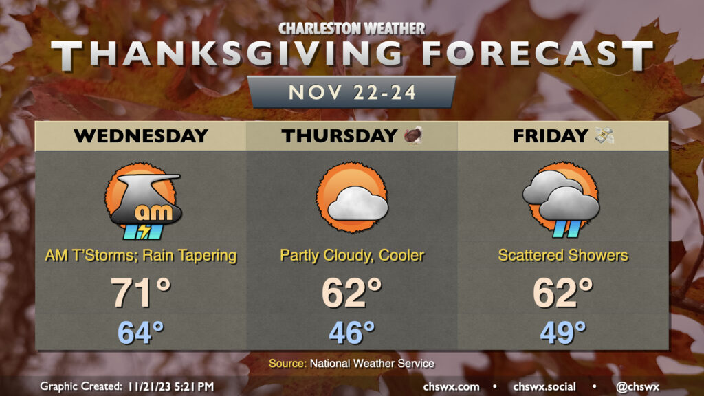
A cold front will continue to approach the area overnight Tuesday into Wednesday, bringing a line of showers and a few thunderstorms along with it that’ll arrive Wednesday morning. Some periods of heavy rain may be possible, and even a couple pockets of gusty winds won’t be out of the question, either. It’ll be one more warm and muggy start with lows bottoming out in the mid-60s. Highs head to the low 70s in the afternoon ahead of the front, which should get through late Wednesday. Once this happens, cooler and drier air will push in, and we’ll wake up to temperatures in the mid-40s on Thanksgiving Day. High temperatures will only reach the low 60s with continued cool advection under partly cloudy skies. Shower chances return on Black Friday as another disturbance moves across, but it won’t be quite as potent and rain shouldn’t be nearly as heavy, nor will it be a total washout. Expect generally similar temperatures to Thursday, so you’ll probably want longer sleeves with a bit of a water-resistant flair to them.
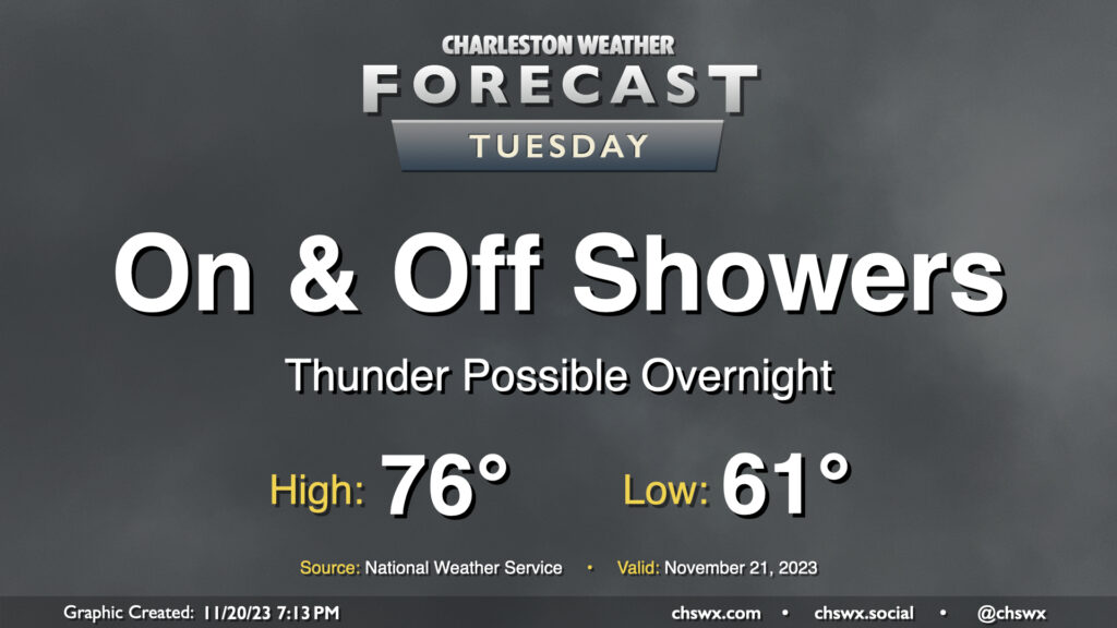
Tuesday’s forecast will be unsettled at times with periods of showers ahead of a cold front that’ll advance through the area on Wednesday. It’s going to be a warm and humid day, with lows around 60-61° warming to the mid-70s in the afternoon. Shower chances will increase as we get into Tuesday night and early Wednesday, and some rumbles of thunder may be possible as well. We need the rain and it looks like we could get a fair bit of it in spots. A half-inch of rain seems to be a decent bet in many locations, with locally heavier amounts possible as well.
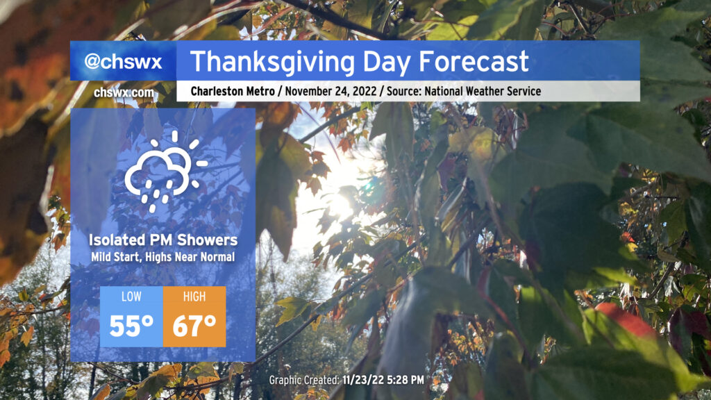
We have a relatively mild Thanksgiving Day ahead as temperatures start in the mid-50s, about 10° above normal for this point in the year. Pesky cloud cover will remain pesky with the coastal trough lingering offshore, and a few showers will be possible before rain chances increase further after sunset as more moisture makes its way ashore. Overall, don’t be surprised to dodge a shower or two, but I suspect that a lot of us get a majority of Thanksgiving in rain-free.
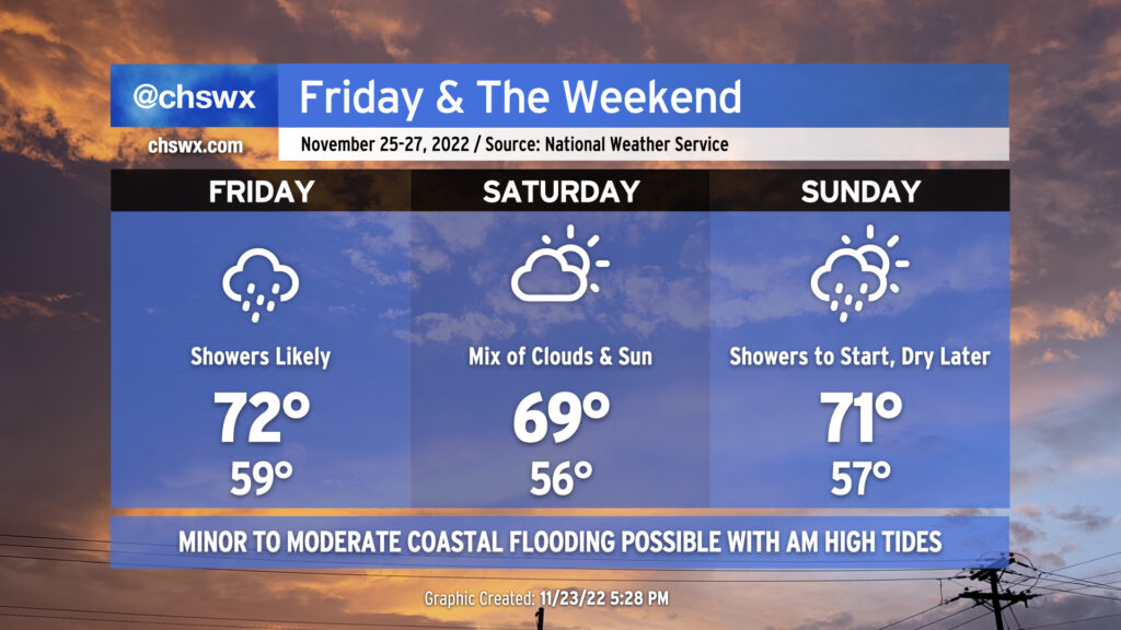
Friday & the weekend: Periods of showers with a nice day in the middle
Shower chances will peak on Friday as a warm front moves by followed by a cold front moving in from the north overnight. Lows will approach 15° above normal with cloud cover and a moist airmass in place. The warm front will help temperatures reach the low 70s in the afternoon despite shower activity that’s expected to be in the area. (A thunderstorm can’t be ruled out, either.) These showers will work their way out of here overnight with the aforementioned cold frontal passage.
Saturday should remain mostly dry with a mix of clouds and sun remaining in place. Temperatures will once again bottom out around 10°+ degrees above normal for another mild start followed by highs running right around 70° in the afternoon.
Showers return to the forecast Sunday as another cold front moves by the area. Once again, highs in the low 70s will follow a seasonably mild start to the day in the mid-50s. We should see showers begin to decrease later in the afternoon, paving the way for a cooler, drier, and sunnier Monday.
Coastal flooding remains a concern with morning high tides
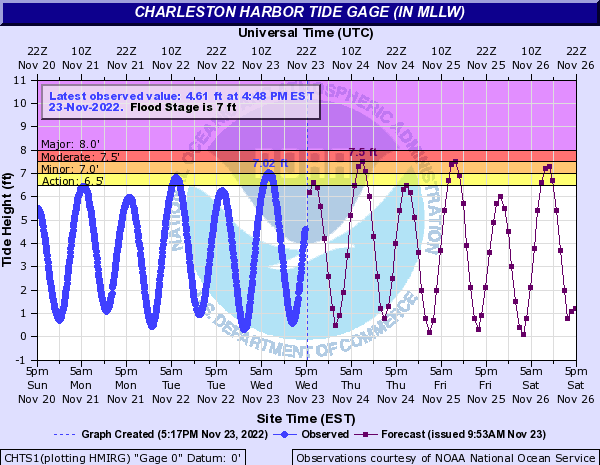
This morning’s high tide peaked around 7.02′, which scraped minor coastal flooding thresholds. Expect additional rounds of minor to moderate salt water flooding around times of the morning’s high tide through Thanksgiving and the long weekend. High tide on Thanksgiving morning is forecast to peak around 7.5′, or moderate flood stage, around 7:43am. We should see similar results from Friday morning’s high tide which is predicted to peak around 8:34am. Minor coastal flooding is forecast for Saturday morning’s 9:29am high tide, while guidance indicates another round of flooding will be possible for Sunday morning’s 10:28am high tide. Stay tuned for Coastal Flood Advisories from the National Weather Service.
Temperatures will continue on a warming trend as we head through Thanksgiving into the weekend. We’ll see periods of unsettled weather, too, but nothing too heinous to write home about.