Believe it or not, it’s already the last full week of July. Climatologically speaking, this week’s forecast is about as end-of-July as it gets: Mid-70s lows each morning, low 90s highs each afternoon with isolated to scattered afternoon thunderstorm chances as the trough that made Sunday in particular quite unsettled lifts out and ridging begins to build back in.
Monday could offer up some slightly better shower and storm chances during the day as a little spin remains in the atmosphere, but a repeat of Sunday’s deluge (more on that in a minute) is certainly not in the cards with generally scattered coverage expected.
Mid-week will feature highs generally 92-93° with a few seabreeze showers and thunderstorms each afternoon in a very standard summertime regime with Atlantic ridging firmly in place. If anything, that will get even a little stronger as we head into the weekend; temperatures will respond appropriately by heading back into the mid-90s on Saturday and upper 90s on Sunday. Dewpoints won’t quite be as nasty as they were this past week, but low-70s dewpoints should still yield a period of heat indices 104-106°.
High pressure will ridge into the area for much of the new week ahead, sending air temperatures up and thunderstorm chances down before weakening into the weekend, bringing back a better chance of afternoon and evening showers and thunderstorms.
The week ahead will feature what passes for a “cooldown” in mid-July followed by a return to temperatures running a few degrees above normal for this point in the year. But first, a soggy Monday as showers and thunderstorms ahead of a cold front take center stage. Some very heavy rain is possible, with another 1-2″ of rain possible across the area with locally higher amounts. We’ll have to watch for the potential for flooding as storms could train across some of the same spots repeatedly; there is also the matter of the 3:07 PM high tide to be concerned about, too, for downtown Charleston. The clouds and rain will keep highs in the mid-80s for the first time since June 23rd, so at least there’s a brief break from the heat. (Silver linings, etc.)
Hot weather continues to start the week before yielding to more numerous showers and thunderstorms starting mid-week. (It’ll still be hot and humid, though.)
We open the week with the risk of a few strong to severe thunderstorms, and get much warmer thereafter as we say goodbye to June and welcome in July, with the first heat advisories of the season possible by the weekend.
We have an unsettled week of weather ahead as an upper low cuts off across the Southeast, blocked in by high pressure to the north — much as we saw at the start of the month, in fact, though we’ll do without the highs in the 60s this go-around.
Warm and unsettled weather will be the rule for much of the week ahead as a trough of low pressure aloft hangs around for much of the week, driving a front close to the area before it stalls out and meanders before washing out over the weekend.
After a prolonged period of below-normal temperatures (not that a lot of us are complaining, mind you), temperatures will begin to feel a little more like June at times this week as the series of cool high pressure wedges takes a little breather. The warming trend starts Monday, as highs top out in the mid-80s — still a little below normal, but much closer than we saw on Sunday with a high of only 75°. Skies will be partly cloudy to mostly sunny, another nice change from Sunday’s generally overcast disposition.
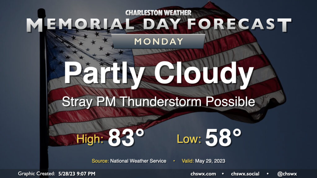
The sun will make a return to our skies for Memorial Day as surface low pressure continues to move away from the area and westerly winds dry things out a bit. We start the day much cooler than normal, with lows bottoming out in the upper 50s. (The record low of 53° set in 1961 remains safe.) Sunshine and the aforementioned westerly winds should help highs top out in the low 80s — a couple ticks below normal as well, but certainly much more seasonable than the 60s and 70s of recent days. The only fly in the ointment may be a stray thunderstorm or two in the afternoon as the seabreeze moves inland. If the beach is in your Memorial Day plans, keep an eye out later in the afternoon as storm motions will be toward the coast. Otherwise, no concerns.
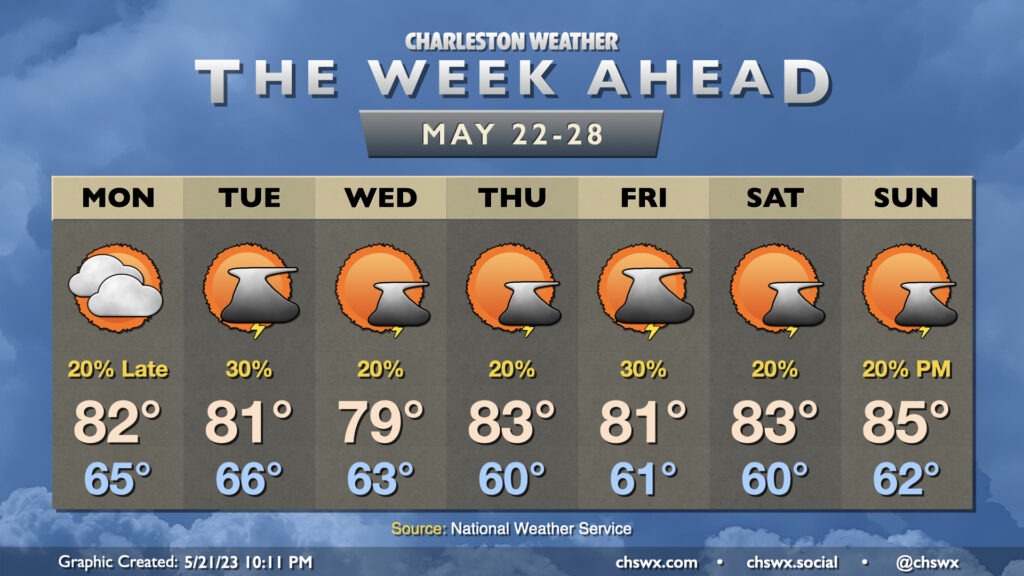
One thing you might notice right away when peering at the week ahead is that temperatures for the week ahead look more like early May as opposed to late May. Highs will generally top out in the low 80s for much of the week (and Wednesday might not even crack 80°!) as cool high pressure builds into the area and stays in force. Upper-level disturbances swinging through will keep isolated to scattered thunderstorm chances in the forecast, primarily in the afternoons (though some popup showers can’t be ruled out in the mornings, either).
The second half of the week will have some details to iron out regarding an area of low pressure that will move northward, parallel to the coast. The question ultimately is how far west it gets; it may spread some gusty rains ashore Thursday into Friday if it gets a little too close. Stay tuned for forecast updates.