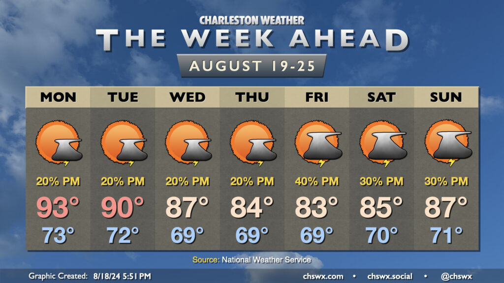
Another break from the heat is in the offing this week as cooler high pressure works its way into the area. We’ll really start to feel it beginning mid-week, and it should last well into the weekend.
One front gets by early Monday, stalling out nearby. This should cut down on coverage of afternoon storms, at least, but a couple storms can’t be ruled out as highs head to the low-to-mid-90s. The cooling trend begins on Tuesday as highs top out around 90°, and will continue for the rest of the week as highs fall into the mid-80s with minimal afternoon thunderstorm chances. Lows will bottom out in the upper 60s fairly routinely as well, with even some mid-60s possible in less urbanized locations.
Temperatures start to warm again as we get into the weekend, but highs should continue to run generally in the mid-to-upper 80s with scattered thunderstorm chances each day.
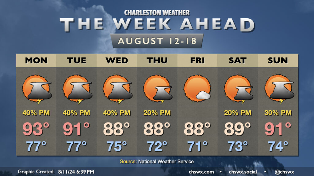
Well, there will be decidedly fewer tropical cyclones impacting the area during the upcoming week, though we will still be living with flooding from Debby for the next few days along the Edisto and Ashley rivers as they continue to fall slowly from record (or very near-record) levels. We at least have something to look forward to as we head into the first school week of the year: some drier air punching in for late week.
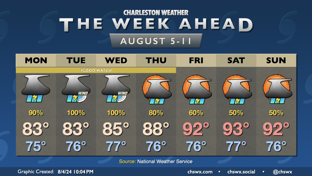
The weather story this week is Tropical Storm Debby. Some rain associated with the system has already tried to push ashore Sunday evening, and there’s a lot more where that comes from as we get into the first few days of the new work week. The forecast continues to call for Debby to stall out and meander over Georgia, causing excessive rainfall that could lead to widespread significant flooding across the Lowcountry over the next several days. We will also deal with the potential for tropical storm-force winds, storm surge, and tornadoes as well. The slow-moving nature of the storm increases the uncertainty about exact numbers for impacts as well as on timing, but we’ll do our best here within the limits of the science.
After a really nice Sunday that featured dewpoints dropping into the low 60s and no rain to speak of, we get one more day of lower humidity before we return to the swamp for the rest of the upcoming week. For Monday, though, enjoy lows around 70° yielding to highs around 90° in the afternoon with dewpoints generally in the mid-60s. We’ll see a mix of sun and clouds throughout the day, but rain should just hold off to our west for one more day. (Can’t rule out some showers near I-95, though.)
I’m back…just in time for more rain. Showers and thunderstorms figure prominently in the forecast this week, especially in the afternoons and evenings, as the pattern generally keeps a trough in the east and a ridge in the west. This keeps us within southwest flow aloft, which keeps disturbances rippling through the area at times and the flow of moisture open from the Gulf. This, in turn, translates to potentially numerous showers and thunderstorms each afternoon and evening as daytime heating kicks in and the sea breeze makes its inland trek.
After reaching 99° at the airport on Sunday — the warmest it’s been since May 29, 2019, when it was 101° in the midst of the Memorial Day heat wave — air temperatures make another run for the upper 90s on Monday after another steamy start in the upper 70s to low 80s as a deep-layer ridge stays in place. Given the moisture in place, heat indices should once again reach or exceed Heat Advisory criteria (108°) in many spots, especially in the Highway 17 corridor. A few showers and thunderstorms will be possible once again Monday afternoon and evening along and ahead of the seabreeze, but with the ridge in place, coverage will be scattered at best. Much like Sunday, we can’t rule out a stronger storm where one does fire if it can realize the considerable instability that will be available to it. Additionally, storm motions should again be fairly slow, and with a juicy atmosphere, some localized flooding will be possible if a storm does fire and hang out for a bit.
A surface trough and the seabreeze keeps shower and thunderstorm chances in the forecast each afternoon for much of the upcoming week. We’ll stay on the steamy side, though, with temperatures generally in the low to mid-90s each afternoon and lows in the upper 70s inland to low 80s near the coast, where additional record high minimum temperature records could be broken this week.
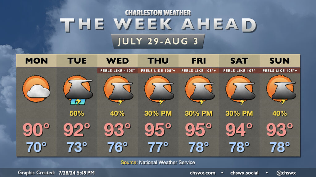
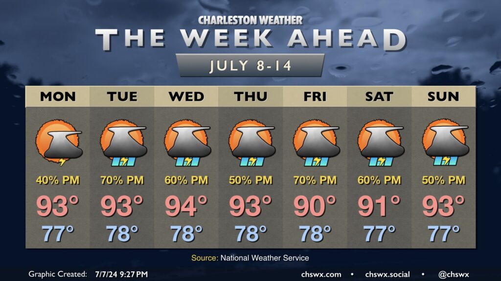
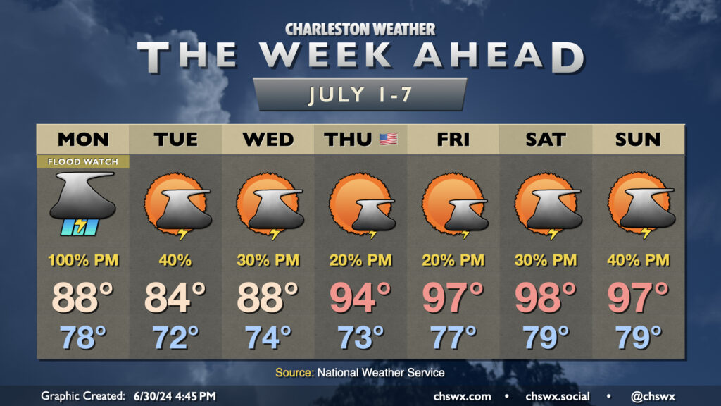
We will get the first week of July off to a very soggy start as a front stalls in the area, bringing a risk for numerous showers and thunderstorms on Monday evening (more on that shortly). While rain chances back off a little bit Tuesday and Wednesday as the front meanders and weakens, we will get at least a brief break from the advisory-level heat that punctuated the end of June. Rain will keep highs to the upper 80s on Monday, while onshore flow Tuesday helps to keep highs tamped down to the mid-80s. Warming begins again Wednesday, though, with upper 80s yielding to mid-90s on the Fourth of July. We’re in the upper 90s for Friday and the weekend with standard afternoon and evening shower and thunderstorm chances expected.
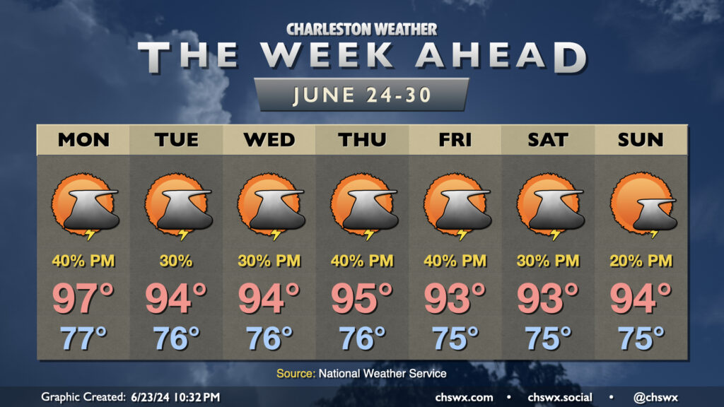
Charleston summer is in full swing as we get into the last week of June as hot and muggy conditions will be prevalent for the foreseeable future.
Monday will be particularly warm with westerly winds ahead of a front that’ll be sagging southward throughout the day. This front along with the pinned seabreeze should help ignite some showers and thunderstorms in the afternoon, but not everyone’s going to get heat relief. We start the day in the mid-to-upper 70s, warming to the upper 90s in the afternoon with heat indices around and even a little above 105° expected. (Note: 105° used to be heat advisory criteria, but that has changed this year — 108° heat index or higher for two hours is the new heat advisory criteria.)
The front hangs around Tuesday before retreating northward Wednesday. This should generally lead to standard afternoon thunderstorms along and ahead of the seabreeze each day. Highs continue in the mid-90s after mid-70s starts both days, with heat indices once again potentially approaching 105°. Rain chances tick up Thursday and Friday as a disturbance moves across the area, while ridging builds aloft for the weekend and starts to reduce afternoon storm chances. Highs continue in the low to mid-90s each afternoon after mid-70s starts, with heat indices flirting with the Heat Advisory criteria especially later in the work week. Be sure you’re taking frequent breaks and hydrating if you’re working outdoors in this swampy weather!
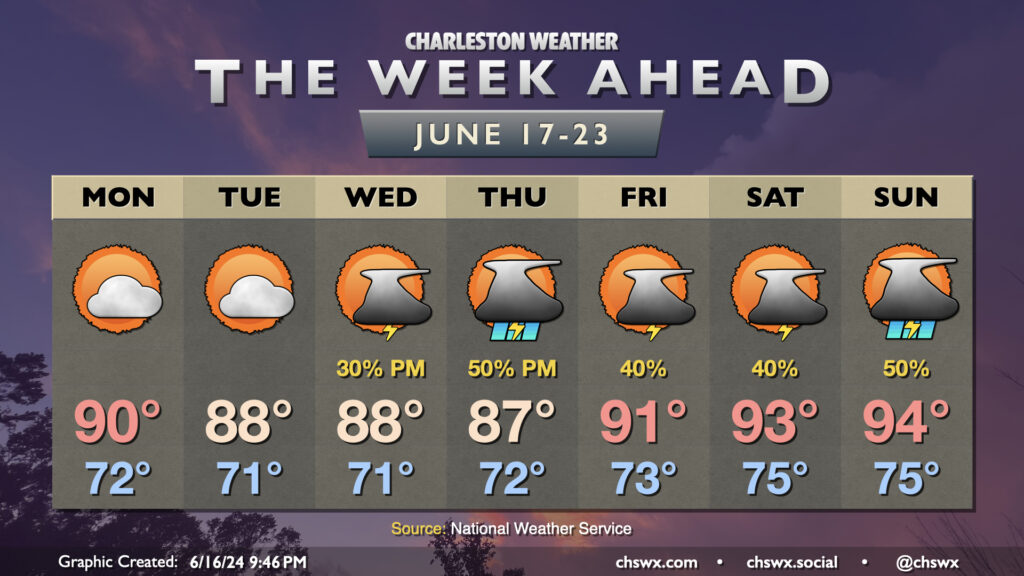
The week ahead will generally feature temperatures around if not even a touch below normal at times through mid-week before warming back up, perhaps into the mid-90s, for the weekend.
We start the week off fairly quietly as a little bit of lower-dewpoint air nudges into the area, generally capping highs in the upper 80s to around 90°. High pressure aloft and at the surface will keep thunderstorm chances very low, so expect to at least get the first couple days of the week in rain-free.
High pressure starts to weaken as we head into Juneteenth, and the standard summertime afternoon thunderstorm chances respond accordingly. Storms could be a little more widespread Thursday as low pressure approaches Florida, enhancing the flow of moisture into our neck of the woods. A warming trend begins Friday as high pressure offshore moves a little further south, turning the resulting flow at the surface more southerly as well and essentially turning the heat pump back on. Low-to-mid-90s temperatures are expected Friday through Sunday, with scattered thunderstorms each afternoon.