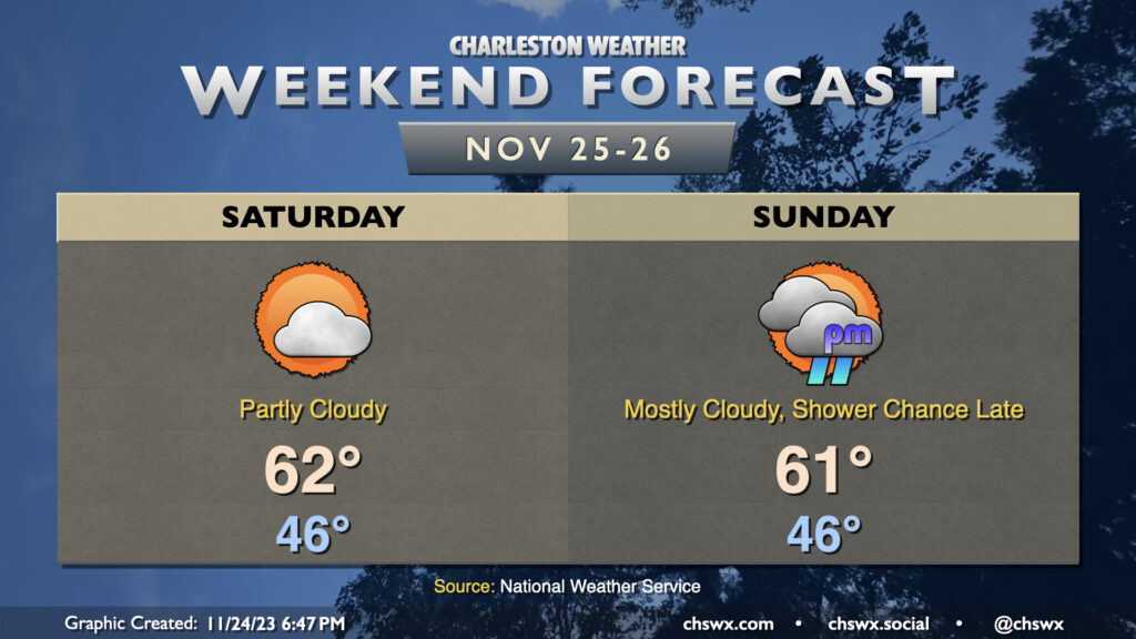
We’ll stay chilly over the weekend as high pressure wedges south into the area, keeping north and northeast winds in place throughout. Temperatures Saturday generally start in the mid-40s before warming to just the low 60s in the afternoon under partly cloudy skies, with clouds increasing as we get later in the day as another disturbance starts to draw closer. Increased cloud cover with the wedge hanging on tight will keep temperatures from getting too far above 60° in the afternoon on Sunday. We should get the daylight hours in rain-free, with showers on the increase as the aforementioned disturbance and associated surface low pass by overnight into early Monday.
The main weather concern will be the risk for coastal flooding early each morning this weekend thanks to the upcoming full moon and northeasterly winds, which are very favorable for piling up water in our neck of the woods. The water level forecast has increased for Charleston Harbor Saturday morning, and we now could look at 7.3-7.5′ with high tide around 6am, capable of closing some roads. Expect a repeat around Sunday morning’s 6:46am high tide as northeasterly winds persist, with water levels likely high enough to produce moderate coastal flooding (7.5-7.7′). Stay tuned for possible Coastal Flood Advisories from the National Weather Service.
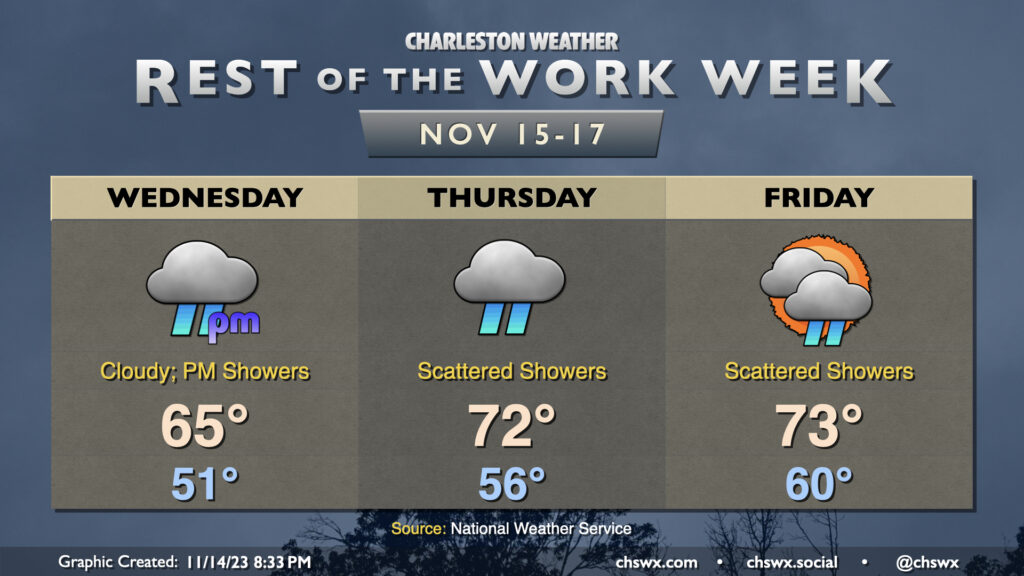
Showers re-enter the weather picture for the second half of the work week, though we’ll warm up a little in the process. Expect overcast on Wednesday before scattered showers commence in the afternoon. It doesn’t look like it’ll be a terribly heavy rain, but it could be enough to make the roads a little slick, so be careful when commuting. Temperatures start in the low 50s and rise to about the mid-60s in the afternoon as the cool wedge of high pressure hangs on for one more day.
The wedge starts to weaken Thursday, and despite overcast with periods of showers continuing, temperatures will run a little warmer. Expect mid-50s to start with low 70s in the afternoon. A few peeks of sun will be possible Friday, though scattered showers are expected to continue. Temperatures will run even warmer Friday, with lows around 60° and highs in the low-to-mid-70s.
Minor coastal flooding will continue to be possible with the morning high tides heading into the weekend. Water levels will generally peak around 7-7.1′ or so each day, which is enough to put some salt water on vulnerable roads in downtown Charleston. The highest tide capable of producing flooding on Wednesday is predicted around 8:47am, Thursday a little after 9:30am, and Friday around 10:30am. Stay tuned for Coastal Flood Advisories from the National Weather Service.
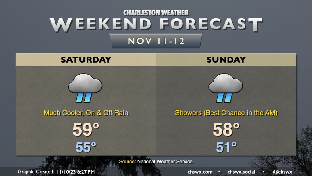
Remember rain? It will be back starting Saturday, along with quite the cooldown in the wake of a cold front that gets through late Friday night. We start Saturday in the mid-50s, but cloud cover and rainfall will keep temperatures from warming all that much — in other words, unless you’re closer to the coast, it’s pretty unlikely you’ll sniff out 60°. Rain continues heading overnight Saturday into Sunday as moisture lifting across the wedge along with a disturbance keeps rainfall in the forecast through at least Sunday morning. We should start to see precipitation taper off heading into Sunday afternoon, though we stay chilly with highs once again expected to stay suppressed to the upper 50s. (Naturally, sun starts to break through Monday, and temperatures begin to warm from there.)
We will need to watch Sunday morning’s high tide (6:50am) for the potential for some coastal flooding as the northeasterly winds help drive water level departures higher. Expect generally minor coastal flooding, though it may yet be high enough to close a few roads for a time. We could see similar flooding Monday morning as well. Stay tuned for Coastal Flood Advisories from the National Weather Service.
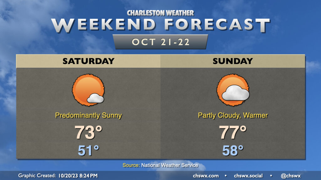
Another beautiful weekend lies ahead as dry high pressure remains in control at the surface. The warming trend that really started to show itself on Friday continues into the weekend. We start Saturday in the low 40s across much of the metro area, with upper 30s further inland and lows near 50° toward the coast. Temperatures will then head into the low 70s in the afternoon under mostly sunny skies.
Don’t forget to set your clocks requiring manual intervention an hour back before you head to bed Saturday night as Daylight Saving Time ends at 2am Sunday. We’ll see temperatures in the mid-to-upper 40s as the sun comes up around 6:40 am, warming nicely into the mid-70s by afternoon. We’ll see a few more clouds as a trough swings through aloft, but the deep-layer dry air closer to the surface will keep us rain-free. The sun will set Sunday evening around 5:30, and it’ll be February 10 before we see another 6PM or later sunset. (Alas.)
Overall, though, it will be a great weekend to get back out and about. Remember how we couldn’t get a dry weekend to save our lives to start 2023? Seems like a distant memory with the great weekends we’ve had as of late — try to take advantage!
This will be an unseasonably warm final weekend of October across the Lowcountry as temperatures will bear more resemblance to mid-May. Expect highs in the mid-80s each afternoon with lows around 60° to start each day. Sunday’s forecast high of 85° would, if it came to pass, tie the record high for October 29 set in 1946. We’ll do this courtesy of stacked high pressure remaining in control for a few more days; dry air aloft will keep cloud cover at a minimum, and it’ll be a good weekend for sunshine overall.
No good weather deed goes unpunished, though: There will be a high risk of rip currents at the beaches in case you are wanting to wade into the water, and morning high tides will be high enough to cause some minor salt water flooding as well. Keep an ear out for Coastal Flood Advisories from the National Weather Service.
A strong front coming by around Halloween will flip the script on temperatures. We’ll go from 83° on Monday to 77° on Tuesday before highs only top out around 60° on Wednesday and Thursday. It’s probably safe at this point to go ahead with a Sweater Weather Watch for next week!
After an occasionally stormy Friday, we have a great looking weekend of weather ahead. Skies clear out overnight Friday in the wake of the front, and by Saturday morning, we’re waking up to brilliant sunshine and temperatures in the low 50s. It’ll be a predominantly sunny day with temperatures topping out in the low-to-mid-70s.
Sunday turns a little warmer, but it’ll remain rather comfortable. Lows in the upper 50s give way to highs in the mid-to-upper 70s in the afternoon with a few clouds at times and a gentle northwesterly breeze. A reinforcing front makes a dry passage late Sunday evening, and this will cool temperatures back down for Monday. Peeking ahead into the forecastable future, there’s very little sign of much in the way of rain as we get into the home stretch of October. This isn’t too abnormal as October is climatologically a fairly dry month here in the Lowcountry, but we are almost an inch off pace still for the month.
Low pressure will move northward across the area overnight Friday into Saturday morning, keeping shower chances (and maybe a rumble of thunder) in the forecast through roughly mid-morning. It’ll be a mild start, with lows bottoming out in the upper 60s to around 70°. Highs will warm into the low 80s, and it’ll generally be a muggy low 80s as dewpoints remain elevated in the upper 60s. Cloud cover will steadily decrease as the day goes on as low pressure continues to move further away.
A reinforcing cold front arrives overnight Saturday into early Sunday morning, and this will bring a much more noticeable change to the airmass. Dewpoints will drop into the 50s, and highs will only top out in the mid-70s in the afternoon. Cloud cover will increase as we get into the evening as a trough approaches the area, but we should still get plenty of sunshine in.
Big (but brief, for now) changes are incoming for our weather in the wake of a cold front that will get through during the day Saturday. First, though, we may dodge a shower or two in the morning as the front gets by, but from there the trend will be for fewer clouds and an uptick in northwesterly winds. We’ll start Saturday in the mid-60s and warm to the low 80s in the early afternoon before cooler air starts to filter in. Dewpoints will drop precipitously starting in the evening, and by Sunday morning, things are going to feel a lot different.
On Sunday, we’ll get off to the coolest start we’ve had since the morning of May 4 with lows bottoming out in the low 50s across the metro. I wouldn’t be surprised to see some 40s in more rural areas. Full sunshine will be in play, but the cooler air moving in will help counteract it, allowing highs to only climb into the low 70s. Bottom line: Take Saturday to make sure your light jackets or hoodies are ready to go because you may very well need them on Sunday! We keep the cooler air going into Monday, but it will be short-lived and we’ll be back closer to normal by mid-next week.
Overall, the weekend forecast is looking solid for doing stuff outside. Expect comfortable starts in the mid-60s (warmer at the beaches), more than ample sunshine (especially Sunday), and warm afternoons with high pressure in control. Saturday looks to be the warmest day of the set with highs topping out around 85° in the afternoon. A reinforcing round of slightly cooler air moves in for Sunday, and that will help cap highs in the low 80s.
We’ll continue to deal with the fringes of Tropical Storm Ophelia on Saturday, though the weather will be gradually improving as time goes on. We’ll see a mix of sunshine and cloud cover, and northwest to westerly winds will still be a little elevated. However, as the day goes on and Ophelia moves further away, we’ll see those winds slacken and some of that cloud cover begin to break a little. The cooler and drier air wrapping around Ophelia will keep temperatures on the low side, with highs topping out in the upper 70s after a comfortable start in the low 60s.
Ophelia will have exited the weather picture on Sunday, and we’ll see much more sunshine and, overall, a warmer day as a result. Expect highs to top out in the mid-to-upper 80s after starting the day in the mid-60s. Winds will have backed down to generally light speeds, too, making for a nice day to get outside a bit. Try to take advantage, if you can!