No weather worries this weekend

We have a really nice weekend of weather coming up as high pressure remains firmly in control across the area. Cool starts will give way to comfortably warm afternoons with highs in the mid-80s and low humidity. Rain chances are nil, and we should see plentiful sunshine throughout the weekend.
Tropical update: Jerry to recurve well away from the East Coast
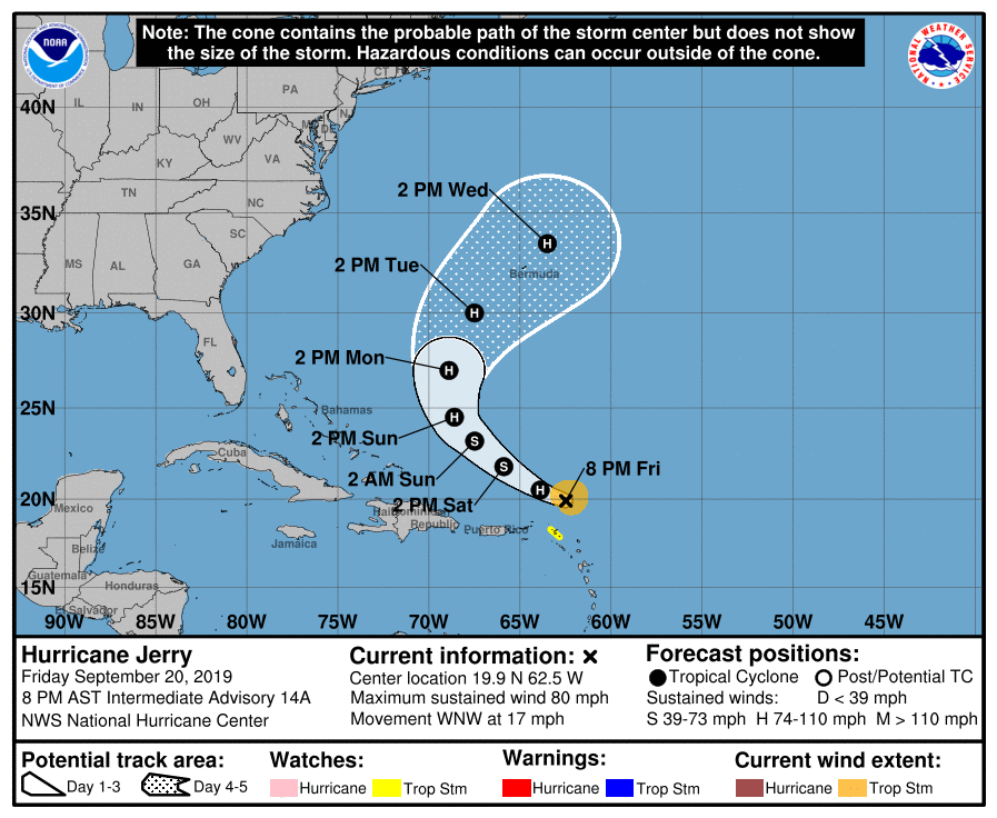
Hurricane Jerry, a Category 1 storm on the Saffir-Simpson Wind Scale with maximum sustained winds of 80 MPH, is bringing some heavy rain to the Leeward Islands. The storm is taking a bit of a hit from wind shear, and as such, has remained a relatively “weak” hurricane. The National Hurricane Center forecast continues to show a northerly turn Sunday into Monday somewhere between 65° and 72° West. Model guidance, as it has for days, agrees with this general scenario, keeping the storm well away from the East Coast. It could send some waves our direction early next week, keeping an elevated rip current risk at area beaches. Other than that, Jerry appears to be a non-factor for our weather.
Three areas of disturbed weather to watch
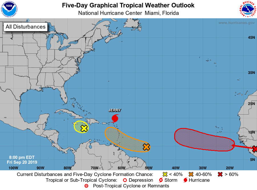
There’s still plenty going on in the Atlantic beyond Jerry, though, with the Hurricane Center monitoring three areas of disturbed weather for possible tropical formation.
The disturbance closest to the U.S., situated near Haiti, is the lowest risk to develop with good upper wind shear in the area, according to NHC. It will bring heavy rain and possible flash flooding to the island, though.
A disturbance east of the Windward Islands has a slightly better chance of developing into a tropical cyclone before running into more hostile wind shear over the eastern Caribbean. NHC gives this system 40% odds of developing in the next 2-5 days.
The most likely source of our next tropical cyclone appears is still over Africa. It’ll be emerging into the Atlantic waters this weekend, and has a high chance of developing (80%) in the next five days.

The next disturbance to strengthen to a tropical storm will be named Karen. (Please hold your memes until the storm is safely away from any landmass.)
Astronomical fall begins September 23, but it won’t feel like it
I wish I could say the cooler weather we’ve been experiencing over the last couple days was here to stay. Alas, though, we aren’t completely done with summer yet, with above-normal temperatures projected well into next week.

Warm and dry weather looks to continue for the foreseeable future as well, with the Climate Prediction Center strongly favoring above-normal temperatures and below-normal precipitation for our neck of the woods as we head into October.
So, as it often goes at this latitude, expect fall to arrive in fits and spurts. It is a transitional season, after all — the best part about these seasons is that between the cooler snaps and the resurgence of warmth that follows, there is a little something for everyone.
Follow my Charleston Weather updates on Mastodon, Bluesky, Instagram, Facebook, or directly in a feed reader. Do you like what you see here? Please consider supporting my independent, hype-averse weather journalism and become a supporter on Patreon for a broader look at all things #chswx!