Fall may be beginning, but summer won’t let go

By the time some of you read this, the autumnal equinox will likely have passed (3:09 am), ushering in astronomical Fall. (It’s been meteorological fall since September 1.) Don’t tell that to Ma Nature, though. High pressure aloft is re-establishing itself, ushering us back into what is effectively a very summer-like pattern for the upcoming week.
The hell is this, man?

To adequately explain what’s happening here, we need to look not only at the surface, but what’s happening aloft as well. The charts above are upper-air charts, forecasted by the Weather Prediction Center at the 500 millibar level. A rather amplified pattern is forecast to develop aloft, with a deep trough in the west and an expansive ridge in the east taking shape by the weekend. This ridge will continue to help drive warmer-than-normal temperatures, even with a weak cold front forecasted to swing through by late week. And aside from that front, high pressure will dominate at the surface as well.
With this summer-like pattern in place, I expect that we might climb a couple notches on the “Warmest Septembers on Record” board before the month is out. Right now, with an average of 79.5°, we are on pace for the fifth-warmest September since records began in 1938. (The warmest September on record was just last year, with an average temperature of 81.5°.)

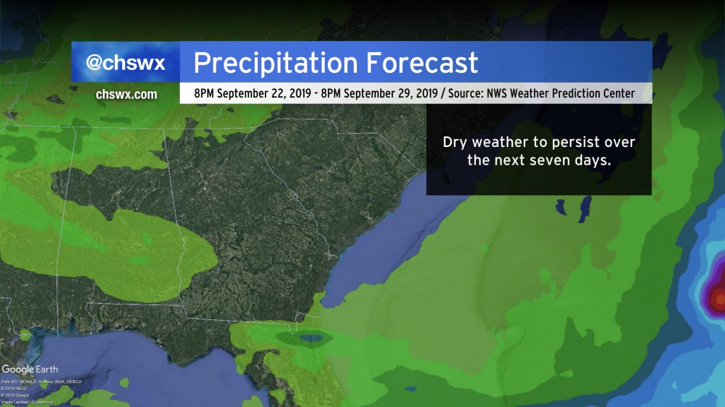
Said ridge will also help put a damper on much, if any rainfall, over the next week. It’s already been a week since we last had a trace of rain at the airport, and that’s not expected to change with somewhat limited moisture and the continued influence of deep-layer high pressure.
Tropical update: I’d like to see a manager
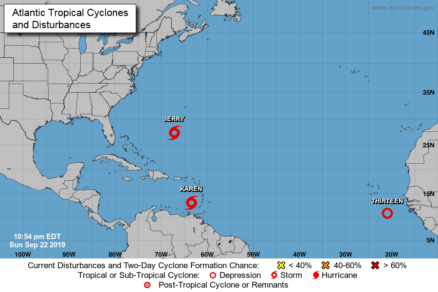
The tropics remain rather busy from a “number of storms” perspective. Tropical Storm Jerry continues to move northward toward Bermuda. Early today, Tropical Storm Karen developed west of the Lesser Antilles, and with the 11 PM advisories, Tropical Depression Thirteen was classified off the coast of Africa. Of these storms, Karen is probably of most interest to the eastern U.S. right now.
Jerry
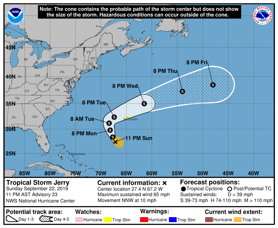
Tropical Storm Jerry continues its NNW trek in the Atlantic, safely to the east of the United States coastline. It’s encountering a fair bit of wind shear, which is inhibiting any further intensification. Still, this might give Bermuda another lashing of strong winds just a week removed from Humberto.
Otherwise, Jerry is not a concern for our weather as it will turn more to the east by mid-week, being carried off into the westerlies and into an extratropical future.
Karen
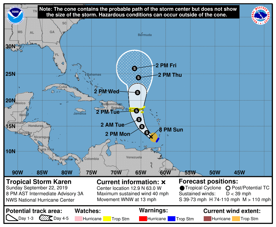
Tropical Storm Karen was named earlier this morning. It’s a weak, poorly organized storm in the eastern Caribbean moving WNW at 13 MPH. It’s expected to follow a weakness induced partially by Tropical Storm Jerry, heading more northward toward Puerto Rico by Tuesday.
As we get later into the week, we’ll want to watch Karen’s forward motion closely. NHC’s forecast has it slowing down as the ridge of high pressure that is responsible for blowtorching us builds eastward across the Atlantic. As this happens, it is not inconceivable that Karen could turn more toward the west and become a feature of interest to the East Coast next week. As is often the case with tropical cyclones, the devil will very much be lurking in the details, and there are more questions than answers right now.
The NHC intensity forecast keeps Karen as a tropical storm through late week as wind shear is forecast to continue working against the system for the next several days. However, as it heads north, conditions may become more favorable for development. Don’t be totally surprised to see a Hurricane Karen at some point.
Bottom line: For now, Karen does not pose an imminent threat to the continental United States and is not something to be concerned about yet. A lot hinges on the strength of the ridge aloft and how far south and east it builds. Check in on forecast updates from the National Hurricane Center, and avoid the spaghetti!
Thirteen
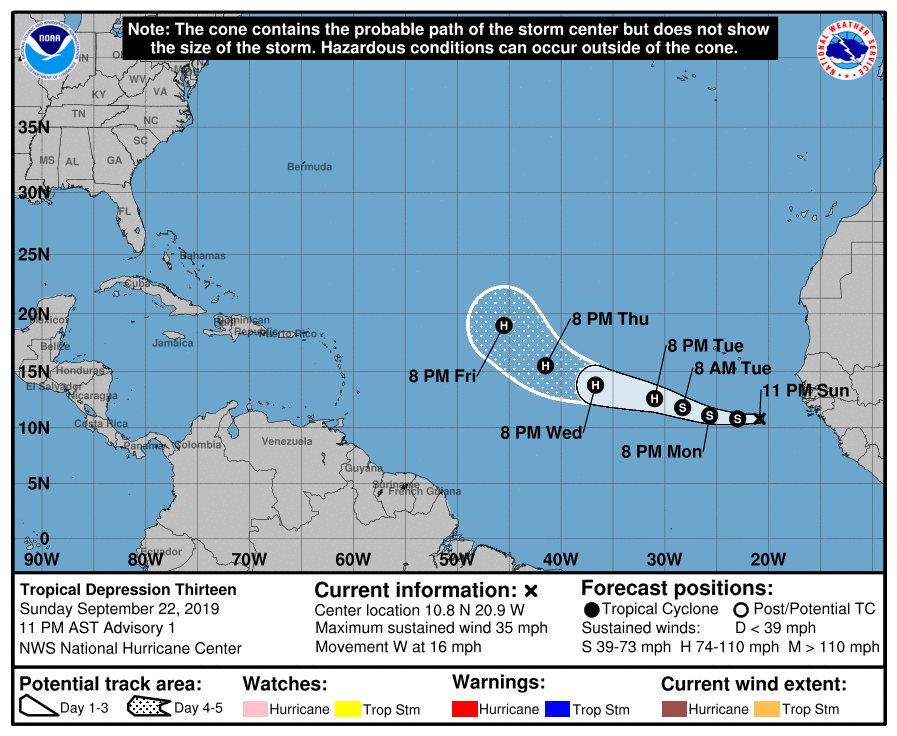
This evening, Tropical Depression Thirteen spun up off the coast of Africa. It’s headed west at 16 MPH, and is expected to become a tropical storm on Monday. It’s a long way from any land mass and will remain that way for the foreseeable future.
Barring another storm spinning up in the Atlantic between now and when Thirteen becomes a tropical storm, expect it to gain the name Lorenzo.

Early returns in the guidance strongly suggest a recurvature somewhere between 40-50° W. We’ll watch it, but the probability of Thirteen/future Lorenzo being a non-issue looks very high at this point.
Bottom line
- A largely rain-free and hot week (by September standards) is coming up.
- There’s a lot going on in the tropics, but there are no imminent concerns.
- Stay tuned for updates on Karen, especially as we head into the weekend as the storm’s future becomes a little more clear.
Follow my Charleston Weather updates on Mastodon, Bluesky, Instagram, Facebook, or directly in a feed reader. Do you like what you see here? Please consider supporting my independent, hype-averse weather journalism and become a supporter on Patreon for a broader look at all things #chswx!