The week ahead: Occasionally soggy and unseasonably warm

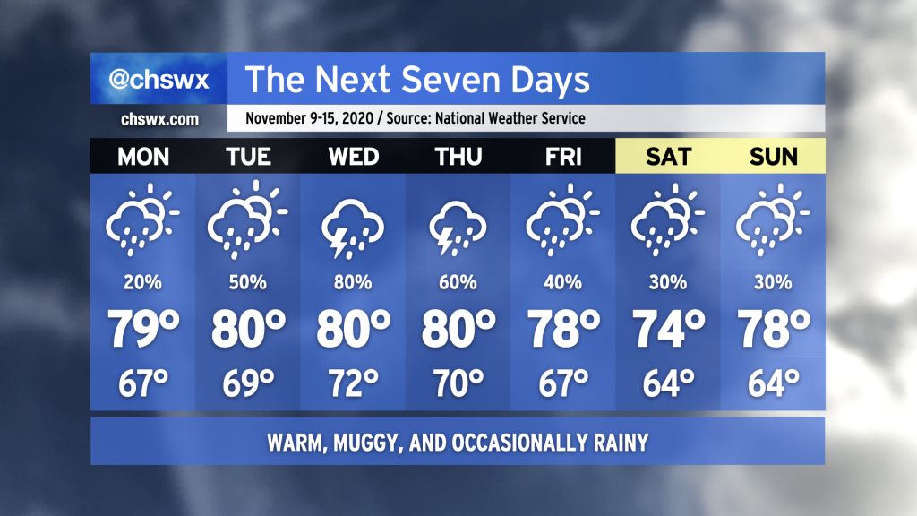
Fall’s hiatus continues this week as we sit between high pressure to the north and Tropical Storm Eta to the south. Monday looks to be the driest day of the week with just a slight chance of showers throughout the day. Rain chances head up into Wednesday as tropical moisture associated with Eta gets drawn up into the area by a frontal system approaching from the west. This front looks to stall out by the end of the week, keeping a chance for showers in the forecast through the weekend. (Eta could make the weekend a little more wet and windy, so consider that forecast somewhat low-confidence at the moment.)
Temperatures will remain rather warm for early to mid-November. NWS notes that some record high minimum temperatures could fall this week, with lows in the 70s forecasted especially Wednesday and Thursday. (For contrast, the typical high temperature this time of year is around 71-72°.) Highs will generally run in the upper 70s to low 80s, roughly 8-10° above normal for this time of year.
If you’re looking for a shift back into Fall, this week ain’t it. While we may cool off as we get into the following week, long-range guidance continues to hit on above-normal temperatures remaining the norm (as one would expect in a La Niña winter, which tends to trend warmer and drier in the Southeast).
Coastal flooding threat this week

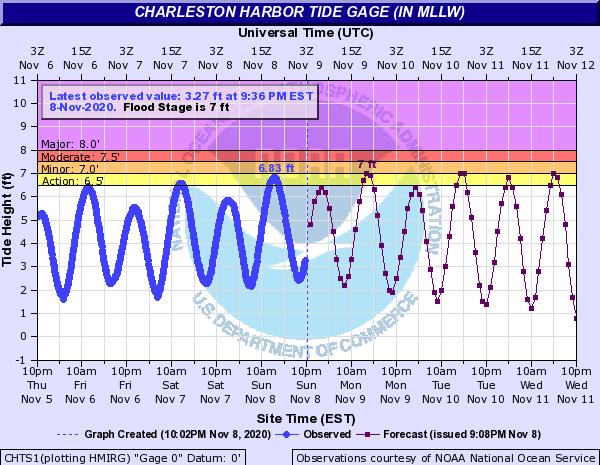
Onshore flow will continue as the Lowcountry remains sandwiched between high pressure to the north and Eta’s circulation to the south. This will help drive tidal anomalies up into minor coastal flood stage at times. Stay alert to possible Coastal Flood Advisories from the National Weather Service as your signal to prepare for possible road closures in Downtown Charleston.
Depending on Eta’s eventual track, we may see even higher departures and more substantial coastal flooding as we get into the weekend thanks to continued and stronger onshore flow around the center of circulation. This scenario remains highly up in the air with lots of model divergence lending plenty of uncertainty to Eta’s track.
Watching Eta

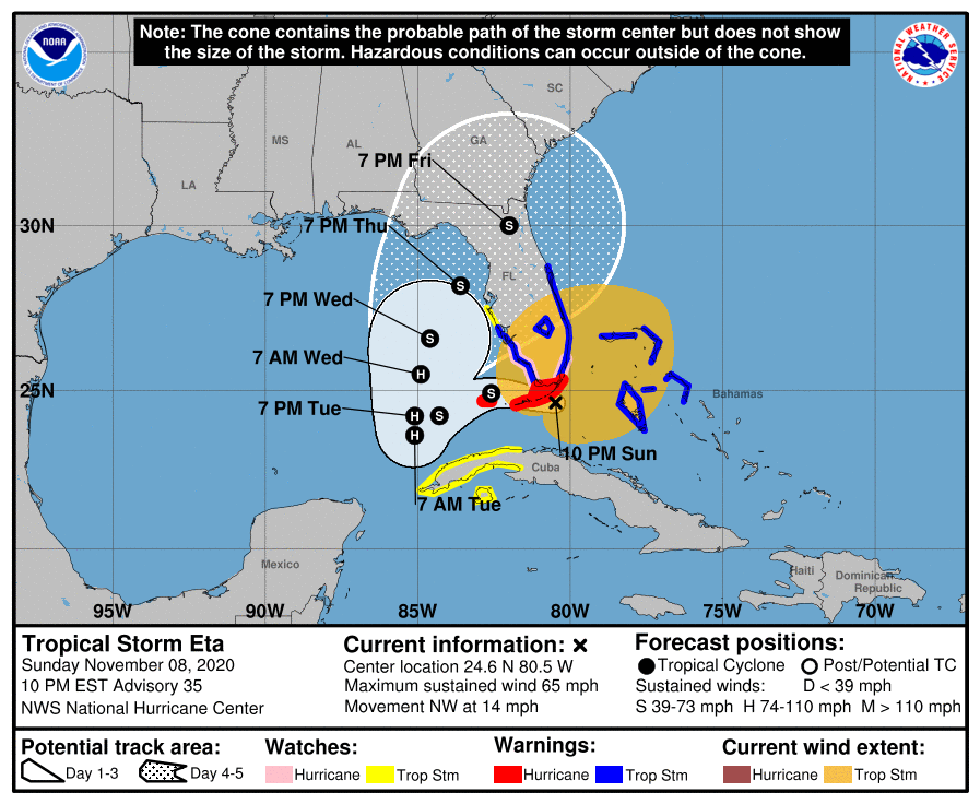
Considerable uncertainty remains with Eta’s eventual path and strength. The National Hurricane Center forecast as of 10PM Sunday evening shows Eta drifting southwestward across the Florida Keys and back into the Gulf of Mexico, where it is forecast to regain hurricane strength for a time before weakening as it approaches the west coast of Florida Thursday. From there, the NHC forecast has Eta being taken up to the northeast across northern Florida and southern Georgia by southwesterly flow ahead of a stalled cold front. We’ll want to watch for the potential for enhanced wind, rain, and coastal flood impacts into the weekend if this forecast verifies.
Model guidance is everywhere on Eta as we head into the weekend. Some solutions keep it in the Gulf to dissipate (GFS) while others keep it going for a little longer, perhaps with yet another landfall, this time in Mexico (UKMET). The ECMWF (Euro) operational run seems to be closest to the NHC forecast at this point, but it’s worth noting that its ensemble members are having a very hard time nailing down a consistent solution (which has been pretty much par for the course for Eta).
Climatologically speaking, it is very difficult to get a strong tropical cyclone this far north in November, and I expect that would hold true for Eta as it deals with land and frontal interaction on its forecast track. This, combined with water temperatures in the upper 60s to low 70s, will preclude anything beyond periods of heavy rain and gusty winds for the Lowcountry. Bottom line: Stay tuned.
Follow my Charleston Weather updates on Mastodon, Bluesky, Instagram, Facebook, or directly in a feed reader. Do you like what you see here? Please consider supporting my independent, hype-averse weather journalism and become a supporter on Patreon for a broader look at all things #chswx!