Friday & the weekend: Showers Friday, frigid for the weekend
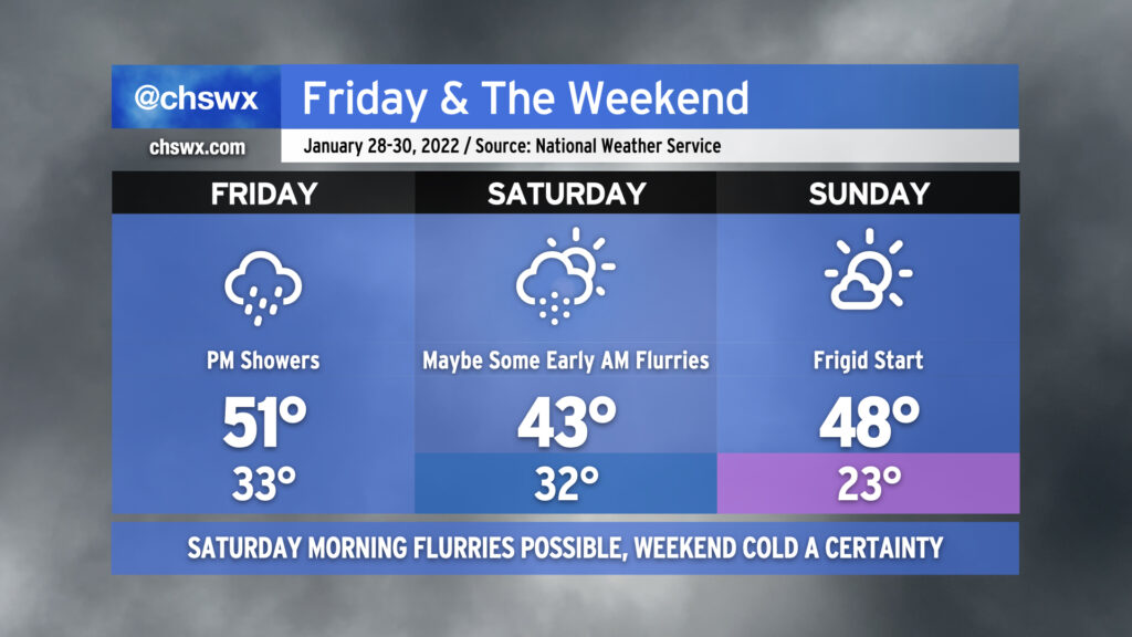
Well, here we are getting into the weekend with another storm system primed to affect the area. Overcast skies will be the rule for much of Friday as showers develop in the afternoon on the periphery of offshore low pressure. Temperatures will only top out around 50-51° given the lack of sunshine and northerly component to the wind.
As we get into the overnight hours Friday into Saturday morning, showers could give way to some snow flurries as colder air punches into the area. I always urge caution with cold-chasing-moisture scenarios like the one we will find ourselves in, but as an upper low traverses the area on the heels of the surface low pressure system moving northeast, it’s certainly conceivable that parts of the Tri-County, especially along and north of a Summerville-Moncks Corner-Jamestown line, could see a period of snow. Flurries will be possible all the way to the coast and perhaps as far south as Edisto as we get toward daybreak Saturday. Accumulations, if any, will be quite light and confined to grassy surfaces, and travel disruptions are not expected. And yes, folks — there will be no ice.
While the risk for snow is still quite conditional (and, to be fair, may not fully pan out), the certainty in the forecast is another shot of Arctic air that will turn this weekend frigid. Temperatures will struggle into the low 40s on Saturday afternoon despite cloud cover scouring out, producing clear skies by the afternoon. Sunday morning is setting up to rival the coldest of the season with lows in the low 20s expected in the Charleston metro area. This is potentially pipe-busting cold, and you’ll need to make sure that pets, plants, pipes, and people are safe and sound Saturday night into Sunday morning. Any bit of light wind could bring the wind chill factor into the upper teens on Sunday morning, too. We’ll keep plenty of sun in the forecast for Sunday, but even then, highs will likely not crack 50°.
The good news is that we begin a sharp warming trend on Monday. As we get into later in the new work week, we may even flirt with 70° for a time. With that in mind, though, the large scale pattern continues to favor generally cooler-than-normal conditions in the eastern half of the US, so don’t change out the wardrobe at the first sign of upper 60s just yet.