Rest of the work week: Mostly sunny & hot, but relief is in sight
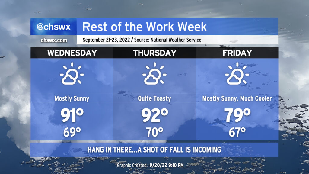
Quiet weather continues for the next several days as high pressure and drier air aloft keep any risk for precipitation very, very low. We’re also staying hot: we reached 91° today and look to do similar numbers for Wednesday under mostly sunny skies. Thursday will be even warmer, with highs reaching the low-to-mid-90s and humidity pushing the heat indices a few degrees warmer.
The heat will break, though, as a cold front swings through late Thursday/early Friday morning. This cold front is legit (and has a great sense of timing, with the autumnal equinox occurring at 9:03 PM Thursday), with a cooler and drier airmass working into the area that’ll knock high temperatures down 10-15° over the previous day. The current NWS forecast doesn’t even crack 80° on Friday! Feels like forever since we’ve had a high that low without any rain, and it will feel quite nice leading into what’ll be an exceptional weekend of weather with mostly sunny skies and seasonable, below-normal temperatures. Hang in there…relief from the heat is coming!
Tropical update: Fiona becomes the first major hurricane of the season and Gaston forms, but 98L is the wave to watch
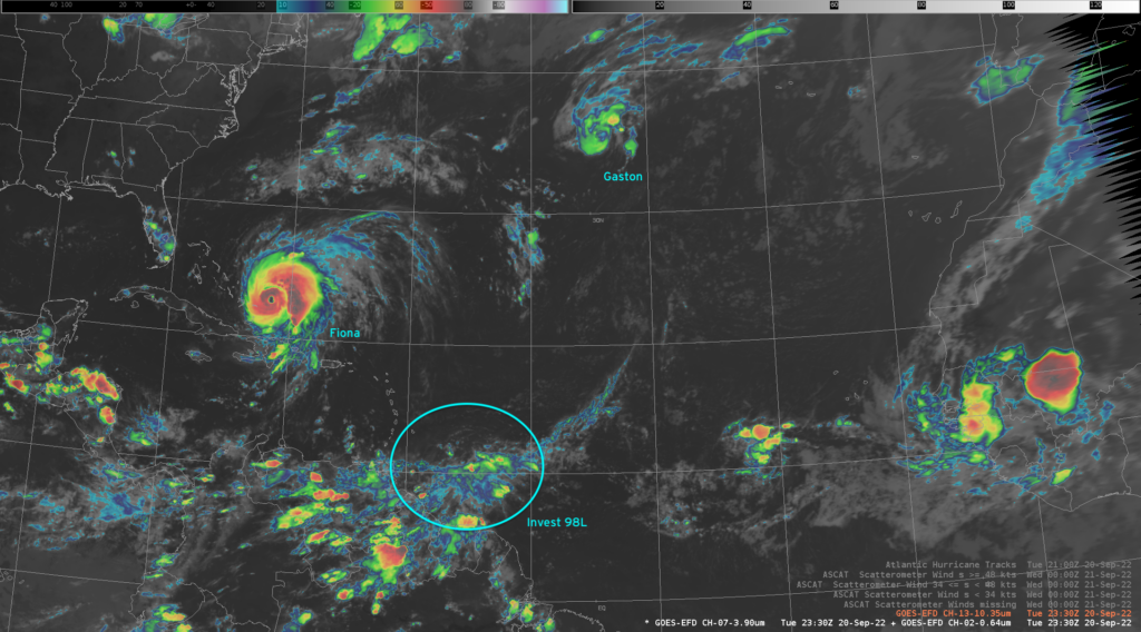
The tropics are certainly looking a little more like the climatological peak that we’d expect from this point in the year. Hurricane Fiona, after a couple days of lashing Puerto Rico, is lifting northward and will make a northeasterly turn tomorrow as it looks to sideswipe Bermuda. It’s become the first major hurricane of the season and continues to strengthen, with max winds of 125 MPH at the 8PM intermediate advisory. The main concern for the Carolinas continues to be rough waves and rip currents; the threat for each begins tomorrow and lasts through the weekend.
Further north and east, Tropical Storm Gaston has formed. It’s headed northeast and should strengthen modestly, but will also stay well out to sea and is not a concern for our interests here at home.
The wave to watch, though, is Invest 98L. It is generating pulses of showers and thunderstorms as it moves toward the Windward Islands over the next few days. Conditions are becoming quite favorable for it to develop, and the National Hurricane Center gives it 70% odds to develop in the next two days, with those odds increasing to 90% over the next five days. In the short term, it has eyes on the Caribbean, where sea surface temperatures and wind shear will remain favorable for the storm to gradually intensify. From there, we’ll have to wait and see on specifics — as one would might expect, guidance more than a few days out is pretty widely spread. With that in mind, though, I’ll be keeping an eye on this one to make sure it behaves.