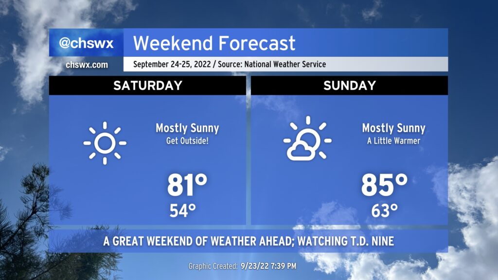
Fantastic weather weekend ahead while we keep an eye on T.D. Nine
High pressure will dominate the pattern this weekend, bringing us excellent weather for outdoor activities.
Saturday will start out as cool as it’s been since mid-May, with lows expected to bottom out in the mid-50s away from the locally warmer coast. Cloud-free skies should persist for much of the day as temperatures head to the low 80s in the afternoon. Winds will be down compared to what we saw Friday, too, which should make it a little easier to enjoy a meal outdoors with a lower risk of unintentional napkin aviation.
High pressure will begin to slip offshore Saturday night into Sunday, and this will make Sunday’s start feel about 5-10° warmer on average across the area with lows bottoming out around the mid-60s. Mostly sunny skies will persist, though, and highs will generally top out in the mid-80s. It’ll be a touch more humid, but certainly not anything tremendously uncomfortable.
The only hazard we’ll need to really be concerned with this weekend is a lingering high risk for rip currents thanks to continued swell from Hurricane Fiona. Inexperienced swimmers should continue to avoid the Atlantic waters this weekend as a result.
Tropical update: Four storms in the Atlantic, but watching Nine for possible U.S. impacts
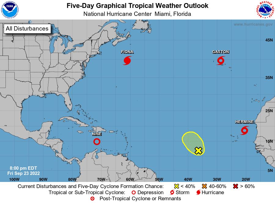
The tropics are hopping, folks. Canada is about to have quite the run-in with Hurricane Fiona as it makes its extratropical transition over the weekend, with a potentially historic storm on the horizon for places like Nova Scotia and Newfoundland. Gaston continues to bring tropical storm conditions to the Azores, while Hermine, minted at 5PM as a tropical storm, looks to stay over water over its expected short lifetime off the western coast of Africa.
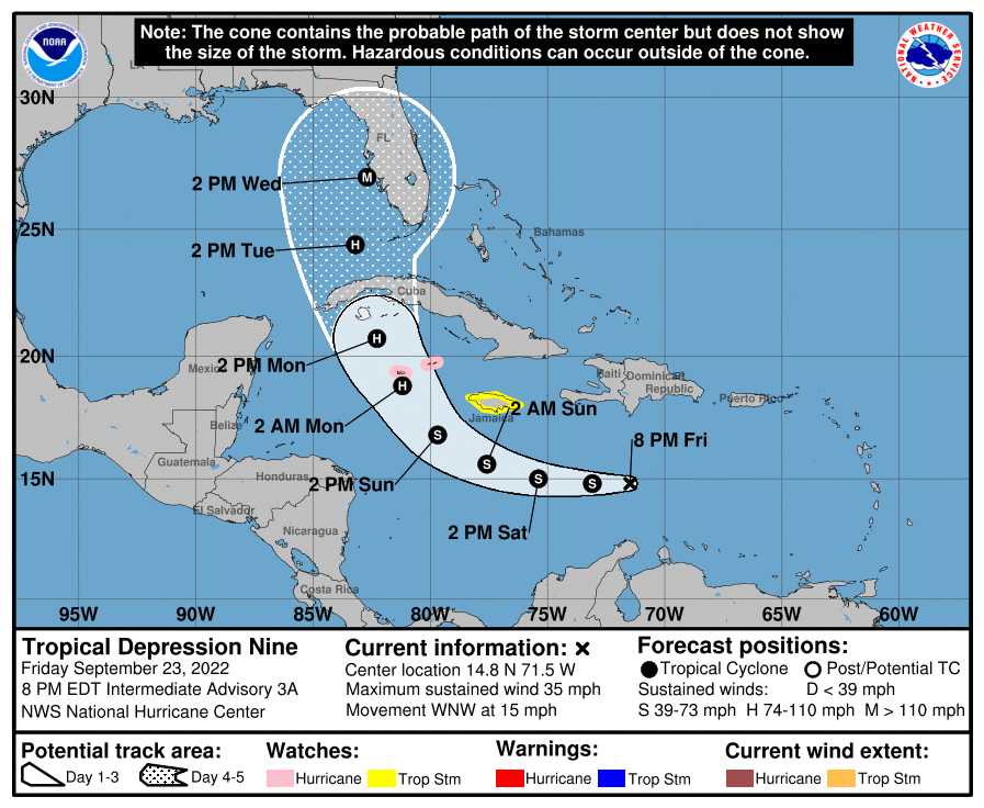
And then there’s Tropical Depression Nine, which formed this morning out of Invest 98L. It’s expected to become a tropical storm by tomorrow. When this happens, it will likely get the name Ian. We’ll be hearing a lot about this one over the next few days as it treks through the Caribbean. The current NHC forecast takes Nine — as a hurricane — over western Cuba on Monday, entering the Florida Straits Tuesday morning on its way to a landfall on the west coast of Florida as a major hurricane on Wednesday.
From there, it remains anyone’s guess as to where it will end up. The guidance suite continues to have tremendous spread in the possible solutions after Wednesday, ranging from a slowdown in the Gulf to the storm passing offshore of the Carolinas. Thus, it remains far too early to speculate about what, if any, impacts we may see from Nine. NWS offices east of the Rockies will be starting 6-hourly balloon launches starting tomorrow to get more frequent upper-air observations into the models to try to help figure this puzzle out as accurately as possible.
With that, we remain firmly in wait-and-see mode. Here’s what to do: Keep an eye on Nine’s forecast updates periodically (but don’t obsess — that’s not healthy!). Give your hurricane plan and kit a once-over to make sure everything is up to date and you know what to do in case Nine’s forecast becomes such that we see a greater threat to the region. Don’t forget to enjoy the weekend’s beautiful weather, too!
Reminder: Avoid the charlatans and always use official info
There’s more information out there than ever about tropical weather, some of which is good and some of which is designed to scare you for profit. It’s so important that you be sure you are only operating off official information from the National Hurricane Center and the National Weather Service in Charleston. (I do!) Model plots are just one tool in the toolbox for forecasters and don’t always represent reality. Unfortunately, there are people who like to share the most dramatic of these model runs for views, likes, shares, and retweets, which drive notoriety and advertising revenue while making headaches for the people who are actually trying to help public safety. Tune them out and stick with the experts at NHC — their track record is such that they most often forecast a storm’s track better than any computer model out there.