Sunday: Turning a little warmer, but still beautiful as we watch Ian
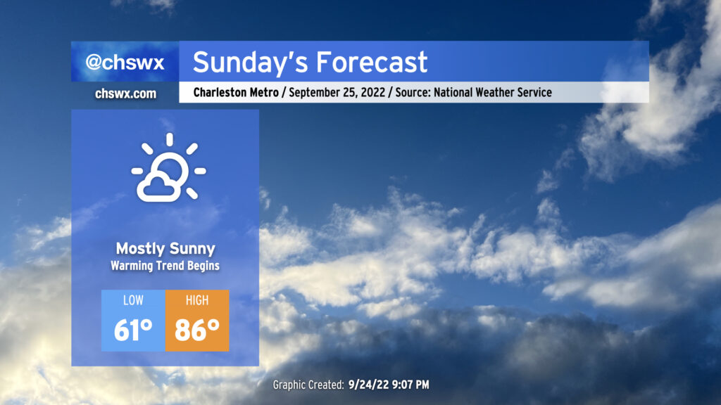
We’ve got another nice-looking day of weather coming up for Sunday. We start the day a little warmer than we did Saturday — lows generally around 60° away from the locally warmer coast — but it’ll still feel nice and fall-like to start the day. High temperatures will head up into the mid-80s in the afternoon under mostly sunny skies; southwesterly winds will bring a little more in the way of humidity into the picture as well, but dewpoints in the mid-60s will still feel alright.
Sunday marks the beginning of a brief warming trend that’ll see us head into the upper 80s on Monday ahead of another cold front. That front should pass with minimal fanfare, though a shower or two can’t be totally ruled out Monday evening. This will set us up for a nice day of weather on Tuesday, with highs in the low 80s expected.
Watching Ian: Westward track trend today, may become a major hurricane in the Gulf
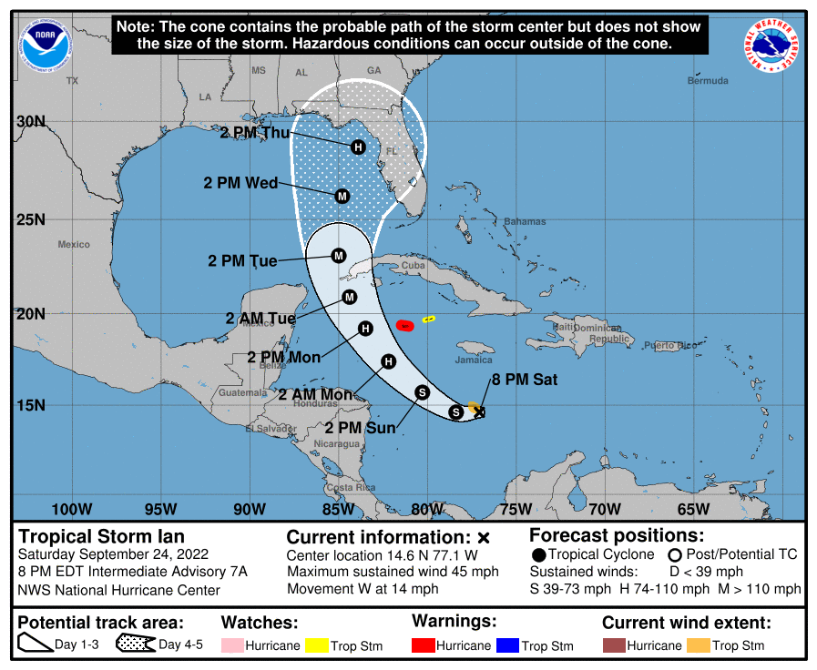
From there, the forecast is as good as muddy, almost entirely hinging on the eventual path of Tropical Storm Ian. We’ve seen a westward shift in the forecast track today, which puts a stronger Ian — perhaps as a Category 4 major hurricane — in the Gulf of Mexico around midweek. There are more questions than answers about where Ian ultimately ends up, hinging primarily on the strength of a trough that’s expected to dip down into the eastern US later in the week. National Weather Service offices from the Pacific Northwest toward the eastern half of the country are releasing six-hourly weather balloons with the intent of sampling as much upper-air data as possible to learn as much as we can about this particular feature and get those frequent observations into the models.
There are also questions around where Ian’s center actually is. There were signs earlier today that it was re-forming a bit more to the west. Small nudges off track from such things can make for downstream track and intensity implications, so that’s another area that’s going to remain rather uncertain until Ian can steady itself; with shear relaxing in the Caribbean, this should happen soon. And once Ian can get its inner core established, rapid strengthening should follow.
Given the current forecast for Ian, it does appear that some impacts are in the cards for the Lowcountry. Right now, the NWS forecast shows showers and thunderstorms likely toward the latter half of the week, with gusty northeast winds shifting southeasterly Thursday into Friday. One can surmise given the wind direction that some coastal flooding may be a possibility as well. What’s not looking likely is the specter of any sort of direct hit; those concerns look confined to the Gulf Coast at this juncture, and guidance has continued to trend away from solutions that cut Ian across Florida and back over the Carolinas.
At this range, there’s still a lot of room for things to change. With any luck, the additional upper-air observations and almost continuous aircraft recon should be able to give us a clearer picture of what Ian will do in the next couple days. For now, the advice remains the same: Stay tuned to forecast updates as there will be refinements over the next few days. As always, be sure to monitor official forecasts from the National Hurricane Center for accurate information on Ian.