Tuesday: Cooler behind a front as we continue to monitor Ian
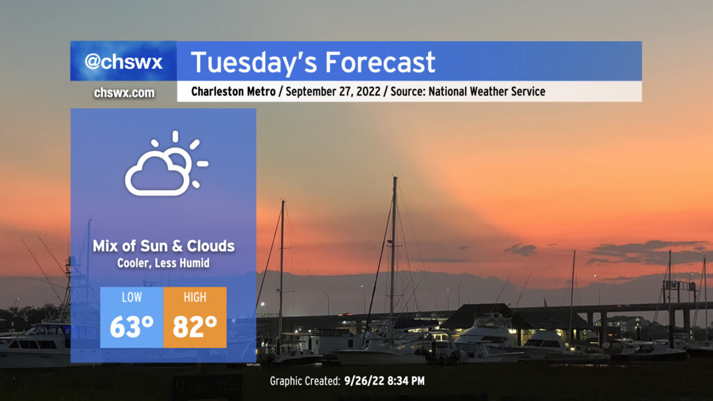
We’ll turn cooler tomorrow as a front gets through tonight. Expect lows to run a few degrees lower in the mid-60s (a touch warmer near the coast where water temperatures still hover around 80°). Highs will get to the low 80s under a mix of clouds and sun as high pressure wedges in from the northeast. It’ll be a good day to get prep work done ahead of Ian, which continues to look to produce impacts in the Lowcountry later this week.
Ian: Latest update
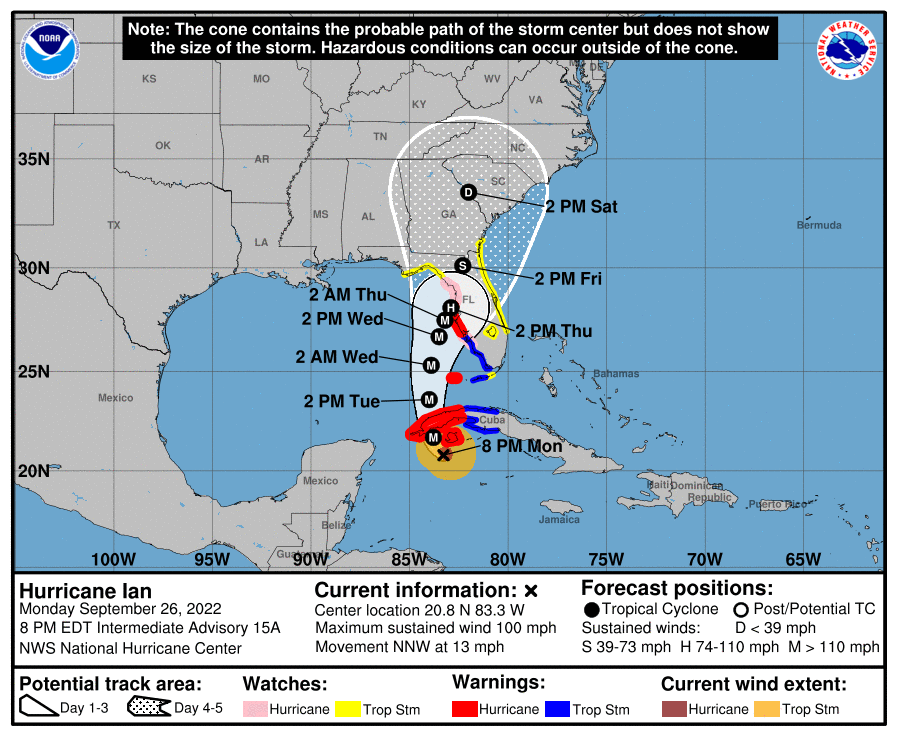
Hurricane Ian continues to intensify this evening as it approaches Cuba. Some dry air has interrupted the circulation a bit, but storms are still firing around the center. Once they get fully wrapped around, we should see Ian become a major hurricane, potentially ahead of landfall on Cuba’s western tip tomorrow morning. Max winds are now at 100 MPH, and it’s moving NNW at 13 MPH. The track takes Ian into the Gulf of Mexico tomorrow afternoon, jogging east of north a bit as it gets uncomfortably close to Tampa, FL. Ian will then slow down as it interacts with a stalled front to our south, potentially pushing quite a bit of surge into Tampa for perhaps a day to a day and a half. Later Thursday, Ian is forecast to get some forward speed back as a trough picks it up. This will also shift the aforementioned front back our way, and with deep moisture being transported across the frontal surface on Ian’s right side, expect heavy rain to develop well before the circulation gets nearby. High pressure to the north and the trough aloft will shear the storm apart, weakening the circulation quickly as it moves northward. It should be a depression by Saturday afternoon as the center makes its closest pass to the Lowcountry.
There’s still quite a bit of uncertainty with this track, particularly after Ian enters the Gulf. Model solutions have been trending a little more eastward this evening, and the NHC has made adjustments to match that. I’ll urge y’all not to get wrapped too much into the details, though, as for now impacts would generally remain the same barring a larger shift in track either west or east. Believe it or not, much of the inclement weather we’re going to see here from Ian won’t come directly from the storm, but will be instigated by a front which will interact with Ian and help wring out a solid feed of tropical moisture across the area.
Ian: Possible impacts
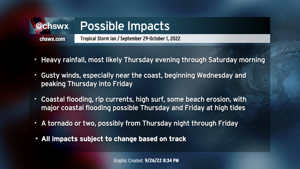
The expected impacts remain centered around water: Heavy rain — on the order to 6-8″ in spots — is expected across much of the metro area possibly beginning as early as Thursday evening. Stiff northeasterly winds, which will begin to develop on Wednesday as the pressure gradient between high pressure to the north and Ian to the south tightens, will help to drive water levels higher in the harbor, which will produce at least minor coastal flooding around high tides on Wednesday. Water levels will increase even more heading into Thursday, with major coastal flooding possible around times of high tide through Friday. We may see another round of tides that make headway into the top 20 on record for Charleston Harbor, and if we put heavy rain on top of that, significant flooding in downtown Charleston and coastal communities could occur. That’ll certainly be a trend to watch closely.
Wind is going to mainly be a factor at the coast and over the waters, with the strongest winds occurring ahead of the system thanks to the aforementioned pressure gradient. By the time Ian’s center approaches our area, the storm will have been sheared apart enough to where maximum sustained winds will be below tropical storm-force. So, while gusty winds and scattered power outages will be possible inland, the better chance for wind-related impacts will be found at the coast, including rip currents and maybe even some beach erosion.
Finally, with the warm front lifting across the area and the resulting increase in wind shear and instability, a tornado or two will be possible beginning possibly as early as Thursday night into Friday. It’s possible this threat could persist into Saturday morning before the circulation lifts north of the area, but we’ll wait and see on that one.
What to do
When preparing for a tropical cyclone impact, you generally want to prepare a category up to allow for uncertainty. So, be thinking about the potential for downed trees and power outages.
- Get some extra batteries and test your flashlights, just in case of a power outage.
- Get a cooler ready just in case of a longer-duration power outage at your location — again, not expecting this to be a widespread issue, but you’ll be glad you’ve got it just in case.
- Pick up loose items from outdoors, particularly if you live near the coast or in downtown Charleston.
- Review your severe weather safety plan in case a tornado warning is issued for your location. Make sure you have a way to hear warnings at night, too. (Your cell phone will do a good job of this, but it’s good to have a weather radio as backup as well.)
- Stay tuned to reliable sources for forecast updates. Look for sober, credible voices, and avoid hype. Listen to local officials for emergency instructions.
- Keep things in perspective: This is not a major hurricane strike, but rather another round of very heavy rain and flooding, which we unfortunately have had a lot of experience with this year. The point here is that we’ve done storms like this before, and we can do it again. It’ll be just fine.
I’ll have updates as needed tomorrow, but otherwise, I expect to do another Instagram Live at 7:30 PM. Hope you can join! Bring your questions and I’ll do my best to answer them during the live. See you then.