Wednesday: Cooler and turning breezy
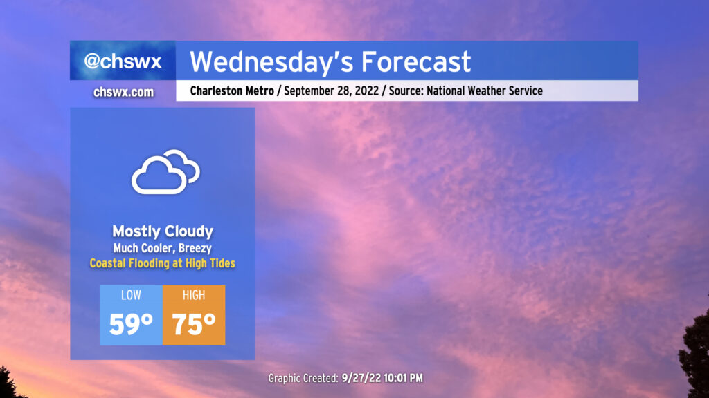
Wednesday will likely represent the last really decent weather day across the Lowcountry before winds begin to turn much more breezy as Ian approaches the area starting Thursday. (A Tropical Storm Warning is now in effect, too.) It’ll be a good day to bring things in from outdoors, check on your batteries, flashlights, and weather radios, and if in a flood-prone area, sandbag property appropriately if needed. We’re in for what might be a tricky few days…but it’s nothing we won’t be able to handle, either.
It’s gonna feel a lot cooler Wednesday, that’s for sure, as high pressure builds in from the north. Winds will turn northeasterly and be gusty at times, with gusts around 25-30 MPH possible, higher closer to the coast. Temperatures will start out in the upper 50s and stay cool, with mid-70s at best with thickening cloud cover ahead of Ian blanketing the skies. We stay rain-free thanks to a deep layer of dry air closer to the surface, however.
Minor coastal flooding will be a concern with the 10:07am and 10:17pm high tides as the northeasterly flow around high pressure to the north drives water levels higher. This could be enough to close a couple roads in the more vulnerable areas, such as around Gadsden Creek. Major disruptions to travel aren’t anticipated, however.
Ian track and intensity update
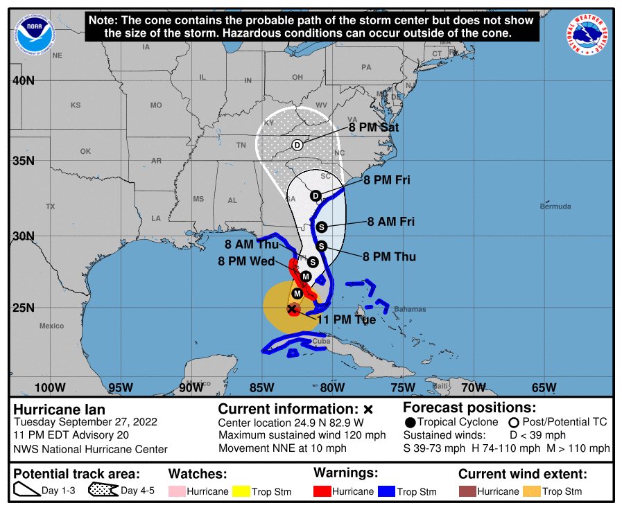
As of the 11 PM advisory (Advisory 20, for those following along at home) from the National Hurricane Center, Ian had maximum sustained winds of 120 MPH and was moving NNE at 10 MPH. It was located 110 miles SW of Naples, FL.
With this advisory, the National Hurricane Center has upgraded us to a Tropical Storm Warning. This means that tropical storm conditions are expected within 36 hours. It’s your signal to wind down your preparation; as mentioned above, Wednesday’s your last solid prep day before things begin to head downhill Thursday.
Landfall around Port Charlotte, FL is expected Wednesday evening. From there, Ian will trudge slowly across the central Florida peninsula, gradually winding down to a tropical storm by Thursday morning. The center will then drift offshore around St. Augustine and make more of a northerly turn as it continues to round a ridge of high pressure. A second landfall as a 45-knot tropical storm is expected somewhere near Savannah Friday evening. From there, the center will move NNW toward the Upstate overnight Friday into Saturday while undergoing extratropical transition as dry air impinges upon the circulation, robbing Ian of its tropical characteristics.
Ian impacts begin Thursday, peak Friday, look to taper Saturday
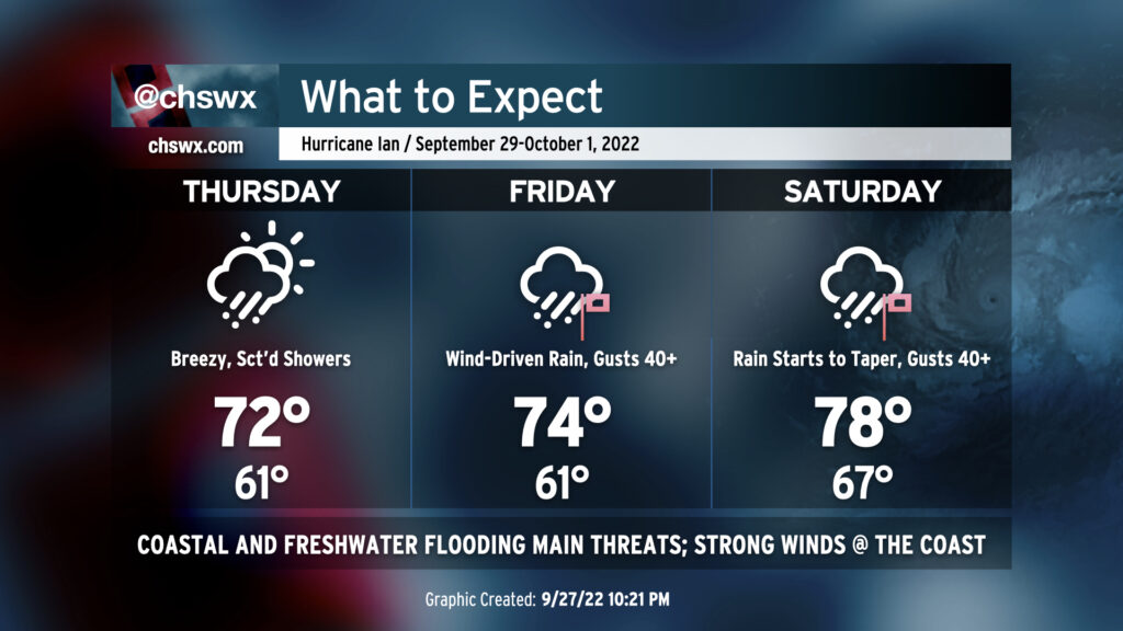
Based on Ian’s current forecast track — and that’s a big qualifier, as there remains considerable uncertainty even this close to the end of the week — we’ll begin to see the first round of impacts on Thursday in the form of major coastal flooding with the 10:50am predicted high tide. The National Weather Service is predicting water levels approaching 8.2′ MLLW in the harbor, which would qualify as a top 20 tide on record if this forecast verifies. This will be enough to close numerous roads as well as cause problems in places that don’t normally see water level issues, including areas in West Ashley near the Stono as well as on James Island along Harborview Road and Long Point Road near Snee Farm in Mt. Pleasant. A second round of moderate to major coastal flooding is forecast around the 11:02pm high tide. The current NWS forecast is around 7.7-7.9′, and these water levels will be able to make similar travel impacts as we are likely to experience midday Thursday.
As Ian moves more northward, the cold front that came through and stalled out to our south will slowly begin to lift toward the area as a warm front. There will still be plenty of dry air to fend off, but some showers will be possible throughout the day as that front gets closer, nudged back our way by Ian’s circulation.
Winds on Thursday will be noticeably gustier than Wednesday, with sustained winds around 20 MPH and gusts to 35 MPH common further inland. Toward the coast, including in downtown Charleston, gusts could approach 40 MPH. Overnight Thursday into early Friday morning, gusts are forecast to increase even further, and could exceed tropical storm force (39+ MPH) with regularity possibly as soon as Thursday evening near the coast.
Friday and Saturday
Friday will represent the peak of Ian’s impacts in Charleston. The aforementioned warm front looks to move ashore early Friday morning, which will advect warmer and more moisture-laden air into the area. It’s going to be a soggy day as frontal lift followed by Ian’s rain bands begin to make their way in. Gusty winds, perhaps upwards of 40-50 MPH (highest values found near the coast and over the waters) in association with this rainfall could down some trees and power lines. Tropical storm force gusts will be possible within rain bands as they move inland, too. Sporadic power outages are a distinct possibility, and why we in the weather enterprise want y’all to be ready for those. There will also be a risk for tornadoes within rain bands given favorable wind shear and instability parameters.
Rain and coastal flooding will be the most serious impacts, though. Several inches of rainfall are expected across the area by the time Saturday’s all said and done, with areas of upwards of 10″ possible near the coast.
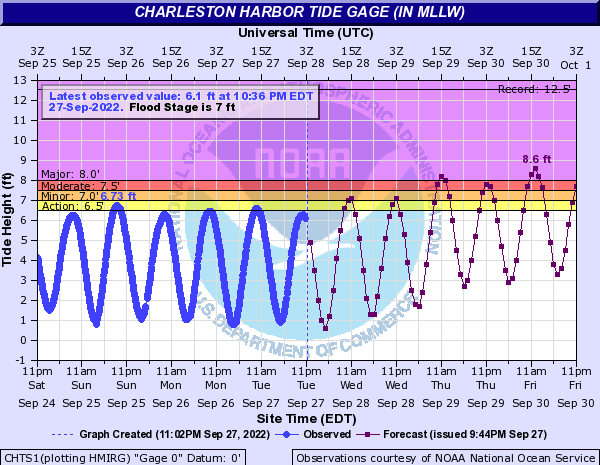
Most critically, we could see very heavy rain on top of tides that could exceed 8.5′ midday Friday, depending on the timing of Ian’s surge. The current NWS forecast calls for water levels to peak around 8.6′, which if verified, would qualify as a top 10 tide on record in Charleston Harbor. (See the records.) The storm’s forward motion will certainly have bearing on just how high these water levels get, but this water level will certainly have tremendous travel impacts across the metro near tidal waterways even if rain somehow takes a breather during the peak.
Based on the NHC track in Advisory 20, Ian is forecast to make landfall around Savannah Friday evening. From there, it will be moving north-northwestward and quickly weakening to a depression. However, we should still be seeing fairly heavy rain through Saturday morning. From there, we’ll see the stronger winds wind down and rain rates diminish as drier air punches into the system. Coastal flooding will remain a concern with the Friday evening high tide, perhaps approaching moderate or even major flood stage once more, and I think we probably can count on a couple more high tides worth of salt water flooding on Saturday before winds shift more offshore late Saturday into Sunday, which should put the kibosh on the most serious threat for flooding.
What to do
- Finish up preparations. Remember to prepare a category up to allow for uncertainty in the intensity forecast. Charge power bricks for your phones. Bring in loose items from outdoors. Grab some batteries, flashlights, non-perishables, and think about a cooler just in case you lose power for longer than you’d like. (Someone always inevitably ends up in this situation with these. If that’s you, you’ll be happy you were ready!)
- If you’re in a flood-prone spot, get your property ready for flooding. That may mean sandbags; check with your local municipality on free sandbags, which many are offering.
- Review your severe weather safety plan as tornadoes will be possible Friday.
- Be ready to hunker in starting Thursday night through Saturday, if at all possible. We should be able to fine-tune this a bit more as we get closer, but for now, I think that’s a sensible range to work with.
Bottom line: It’ll rain a lot, it’ll be windy at times (especially in the immediate Charleston area near the coast), but it also won’t be anything we can’t handle nor have been able to handle in the past. We’re gonna be fine. Stay tuned to reliable forecast updates through the next couple days as the forecast is fine-tuned and uncertainty (hopefully!) reduces.