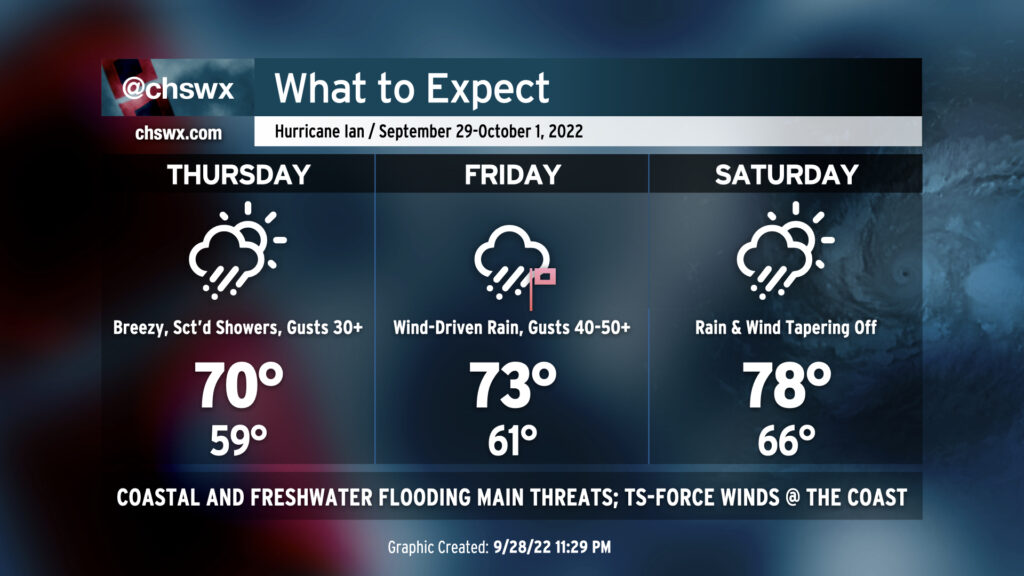
What to expect: Ian impacts begin Thursday, peak Friday, taper Saturday
We are breezy but rain-free this evening as dry high pressure remains in control of our weather. It will hang on for a bit for the first part of Thursday, but a gradual deterioration in weather will begin in the afternoon. It’s a good time to finish gathering supplies for a rough period of weather beginning later Thursday through Saturday morning.
Advisory 26 details and forecast synopsis
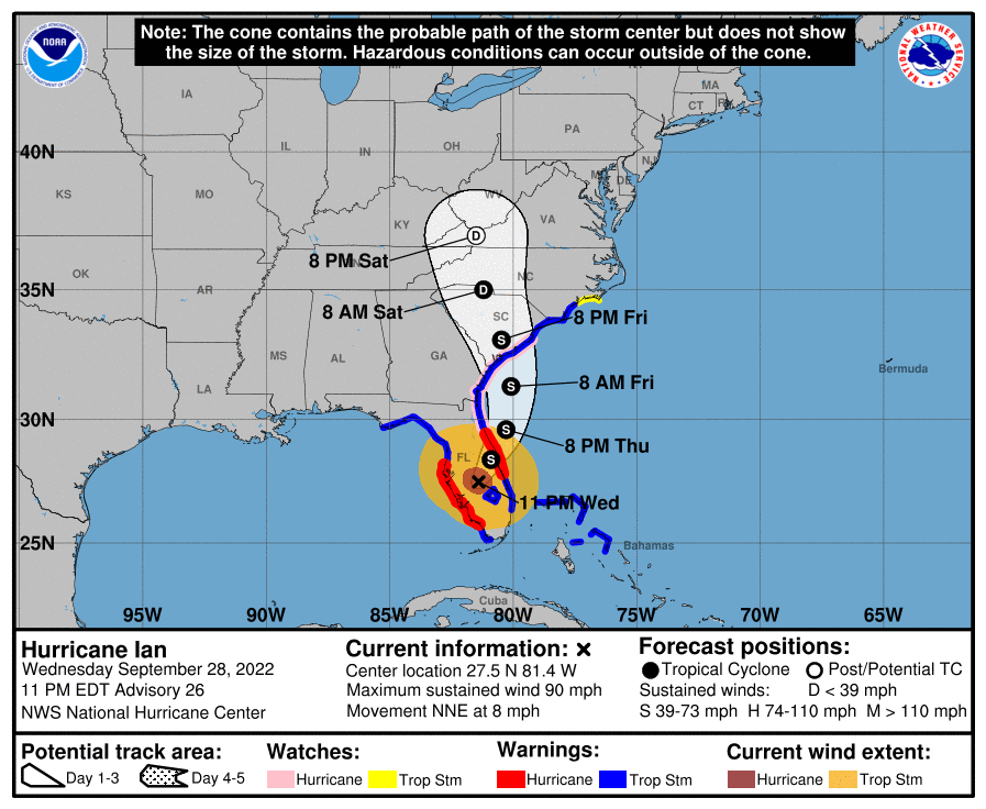
Hurricane Ian lashed Florida’s west coast with storm surge, Category 4-strength sustained winds (the storm was estimated as having 145 MPH max winds at landfall), and tremendously heavy rain during the day today. It will continue to move across the Florida peninsula tonight and gradually lose strength through Thursday morning. It’s then forecast to emerge off the east coast of Florida roughly in the Daytona Beach-Titusville corridor by Thursday evening. Time over water and some favorable upper air enhancement will help maintain Ian’s strength as it turns back northward toward a landfall somewhere between Savannah and Charleston — right now, with some eastward track shifts, it’s looking a little like Edisto — Friday afternoon as a strong tropical storm with max sustained winds of 65 MPH. This is stronger than was forecast with the 5 AM advisory, and has precipitated a Hurricane Watch as hurricane conditions along the coast may be possible if Ian emerges back into the Atlantic as a hurricane, or even gains some strength despite some shear.
Numerous alerts are in effect or will be going into effect across the Tri-County area in response to Ian:
- Tropical Storm Warning for Berkeley, Charleston, Dorchester
- Storm Surge Warning for coastal Charleston
- Hurricane Watch for Berkeley, Charleston
- A Flood Watch for Berkeley, Charleston, and Dorchester effective at 8 PM Thursday through 8 AM Saturday
- High surf advisories and a high rip current risk are also in effect at area beaches
Let’s dive into the timeline a bit, with the caveat that changes in track and forward speed could alter this.
Thursday: Turning windier, showers beginning in the afternoon
On Thursday, high pressure will continue building southward into the area while Ian continues to move northward. This will further pinch the pressure gradient which has already brought some gusty winds to the region today, and could precipitate gusts to tropical storm force at the coast by evening.
The main concern for Thursday, however, will be coastal flooding. Major coastal flooding is expected with the 10:50 AM high tide, with water levels approaching 8′ mean lower low water in the forecast. This will close numerous roads in downtown Charleston, cut off some routes completely (such as the offramp from 17 to 61 entering West Ashley), and even begin to cause problems for areas such as James Island and Mt. Pleasant at Long Point near Snee Farm. If you must travel downtown during the day Thursday, be ready for traffic snarls and the need for alternate routes downtown.
Showers should begin Thursday afternoon; we’ll see periodic but generally light rain heading into Thursday night. Gusts will continue to increase, however, as the pressure gradient tightens between Ian to the south and high pressure to the north.
Friday: Peak impacts
Friday will represent the peak of Ian’s impacts here in the Lowcountry. Friday morning, a warm front will push ashore with a band of very heavy rain to go with it. The airmass behind the warm front will be very moist and somewhat unstable, and with wind shear such that it is in the right-front quadrant of a landfalling tropical cyclone, a few tornadoes can’t be ruled out during the day especially as Ian gets closer to the area.
The main issue will again be water, though. The aforementioned heavy rain band may lay down a few quick inches of rain in some spots, and if those spots include downtown Charleston, we could be contending with freshwater flooding to start the day. Then, the tide will roll in. It’s forecast to peak near 8.7′ MLLW by about midday, which would be good for seventh highest on record at Charleston Harbor if it verifies. It’s likely that rain will be ongoing at this time as well, which could cause numerous travel issues during the day downtown with many flooded roads well beyond the usual tidal trouble spots. Additionally, we’ll want to watch Church Creek in West Ashley carefully for rapid water rises that may threaten the Hickory Hill and Shadowmoss subdivisions.
Friday afternoon, Ian’s center is expected to make landfall somewhere along the southeast SC coast. With the 11 PM advisory, NHC shifted the track a click right, calling for landfall around Edisto as a 65 MPH tropical storm. This may have impacts on how much wind we see in the metro area; to that end, the entire Tri-County area is now under a Tropical Storm Warning. Sustained tropical storm-force winds are quite probable at the immediate coast Friday afternoon, with even some hurricane-force gusts possible. Further inland, winds approaching tropical storm-force will be possible especially near the center, with gusts to 40-50 MPH a likely proposition inside of rain bands. Expect scattered power outages and downed trees even where winds are not as strong; saturated soils from heavy rain will weaken roots and make trees more vulnerable.
Saturday: Winding down
On the current forecast track, Ian should begin weakening quickly after landfall, spinning down to a depression as it accelerates north-northwest toward the Midlands and eventually the North Carolina Piedmont by Saturday morning. Dry air is expected to be punching in from the south, which should shut off much if not all of the rain. For now, NWS is maintaining a 50% chance of rain to allow for variability in the track, but there is a decent shot that we may get in a good bit of Saturday rain-free. Breezy conditions will continue, but winds will also be winding down as Ian’s remnant circulation weakens and moves away.
What to do
- Continue to follow forecast updates.
- Finish up preparation by sunset Thursday; beyond that, winds may become problematic.
- Review your severe weather safety plan for the potential for isolated tornadoes on Friday.
- Breathe. We’ve done this before, and we’re gonna do it again. And we’re gonna end up just fine.
Finally, a fun fact…
This is the 1,000th post published on this incarnation of the Charleston Weather blog. It’s somewhat fitting that it has to do with a tropical cyclone, as that’s where this site has often shined over the past few years. Thanks to everyone who has read, shared, or otherwise found one of these posts useful! Here’s to a thousand more!