Rest of the work week: Showers and a few thunderstorms Wednesday into Thursday sets up a nice Friday
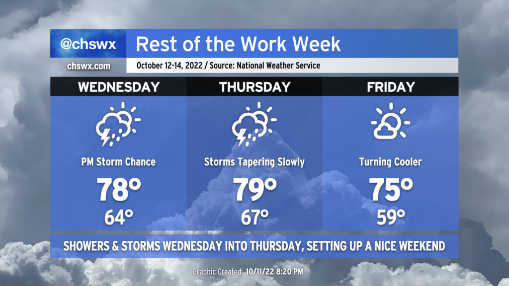
The weather will take a turn more toward unsettled starting Wednesday afternoon as some upper-level energy well out ahead of a cold front helps to induce some showers and thunderstorms across the area.
Wednesday will start fairly mild with lows in the mid-60s thanks to persistent cloud cover. Winds will stay onshore, but despite this, we should still top out solidly in the upper 70s in the afternoon ahead of thunderstorms. It certainly seems that we may get a majority of the day in rain-free, with rain chances starting to head up around commute time.
The greatest risk for showers and thunderstorms looks to be after sunset through early Thursday morning. It’s likely we’ll get a good bit of Thursday morning in rain-free, allowing highs to top out near 80° in the early afternoon. Then, it’s possible that some showers may redevelop ahead of the cold front itself as its timing should coincide with peak heating. The front gets through Thursday evening, and by Friday, we’re starting out quite a bit cooler — upper 50s as opposed to mid-to-upper-60s — with highs topping out in the mid-70s under quite a bit of sunshine. This will set up a beautiful weekend of weather with plenty of sunshine and comfortable temperatures, though perhaps not quite as cool as mentioned yesterday. Still, though, mid-to-upper 70s remain below normal for highs for this point in October.
Coastal flooding threat coming to a close
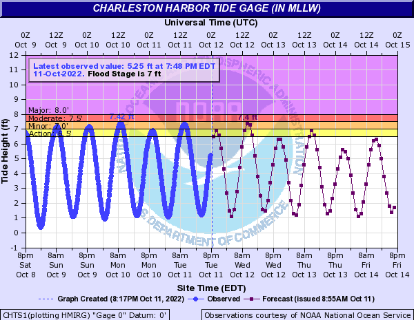
We’re about to close the books on this round of tidal flooding as astronomical influences continue to wane and winds turn more offshore beginning Thursday. Still, one more round of minor to moderate flooding is expected a couple hours around the 10:22am high tide Wednesday, so be ready to use alternate routes if you are out and about mid-morning through about lunchtime. We may also scrape the minor coastal flood threshold Thursday morning, but this doesn’t look to be a significant event.
Tropical update: Short-lived Karl headed to Mexico
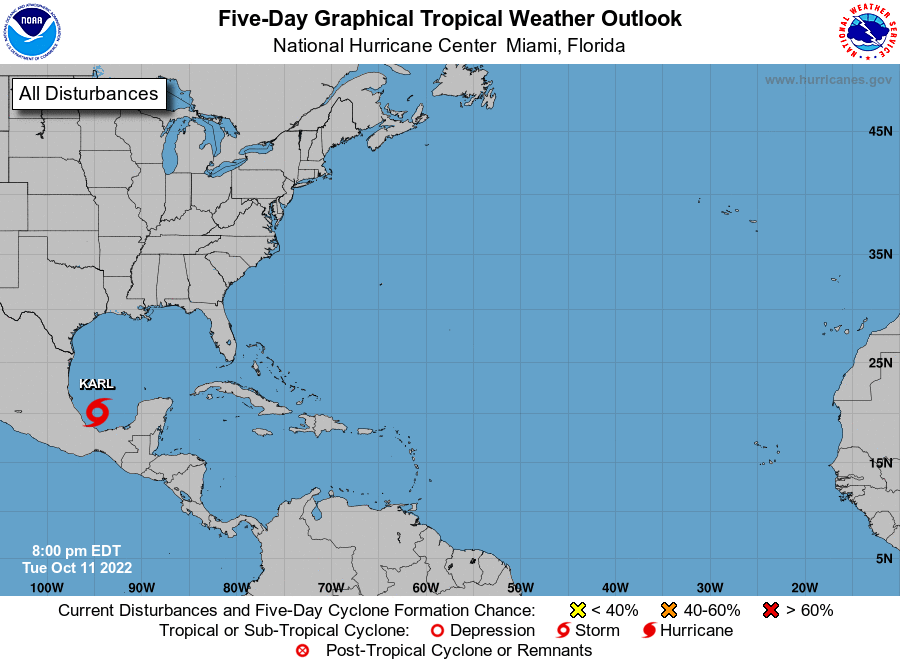
The unsettled weather in the Bay of Campeche I mentioned last night got its act together today and became Tropical Storm Karl this evening. It is no threat to us here at home; it will wander a little north before it is steered into Mexico by Friday. Karl’s development is a good reminder of tropical climatology as we continue through October, with the focus for development shifting back west toward the western Atlantic, Gulf of Mexico, and the Caribbean Sea.
Elsewhere in the tropics, there are a couple waves moving along the 10th parallel generally around the Windward Islands and at about 45° W, but these are weak and not showing any signs of organization. A couple clusters of storms are also headed off the western African coast and will hit the Atlantic by tomorrow, but it’ll run into a wall of strong westerly wind shear. As such, NHC doesn’t expect any additional tropical development over the next five days.