Rest of the work week: A touch less humidity for a couple days, but warming back up for the Fourth
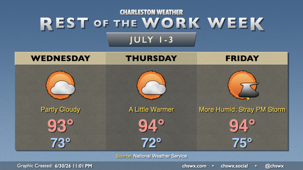
High pressure remains the primary weather driver at the surface and aloft for the rest of the work week, keeping temperatures toasty. Northeast flow over the next couple days, though, helps to bring in some drier air, which will keep heat indices from popping off too much. Wednesday starts in the low-to-mid-70s, with temperatures warming into the low to mid-90s in the afternoon under generally partly cloudy skies. The aforementioned stacked high pressure and influx of drier air will keep convection to a minimum.
We turn a little warmer Thursday, but overall expect a similar day to Wednesday with partly cloudy skies, temperatures in the mid-90s, and heat indices in the mid-to-upper 90s as dewpoints tick up a degree or so. As high pressure aloft weakens and surface high pressure starts shifting back into the Atlantic, the risk for isolated afternoon thunderstorms along with heat indices breaching 100° returns to the picture for Friday. Expect to start Friday in the mid-70s inland to the upper 70s near the coast, warming to the mid-90s in the afternoon. Heat indices should peak in the 100-102° range owing to increasing dewpoints.
Independence Day: Heat and humidity continue to tick up
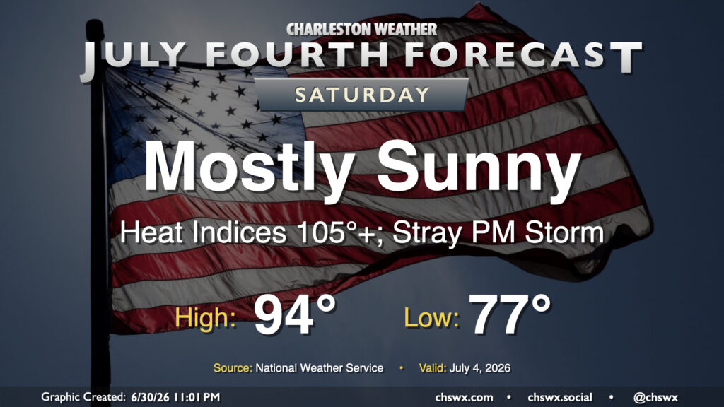
Heat and humidity continue to build heading into the Fourth of July. Muggier dewpoints in the mid-to-upper 70s will be common, with the highest values near the coast. Air temperatures peak in the mid-90s inland and the low 90s near the coast as the seabreeze makes a fairly standard inland trek throughout the day. It’s immediately behind the seabreeze where upper-70s dewpoints will pool, combining with air temperatures in the mid-90s to spike heat indices over 105° before the maritime air turns air temperatures slightly cooler. There will be a risk for an inland-advancing shower or thunderstorm during the afternoon, but modeled storm motions will push any rain away from the beaches with time. Thunderstorms will be disorganized, though any storms that form as the result of outflow and/or seabreeze interactions could briefly turn strong to severe. That being said, most of us should stay out of the rain. Just be sure to get plenty of water and shade during the peak of the afternoon!
Follow my Charleston Weather updates on Mastodon, Bluesky, Instagram, Facebook, or directly in a feed reader. Do you like what you see here? Please consider supporting my independent, hype-averse weather journalism and become a supporter on Patreon for a broader look at all things #chswx!