Jared Smith founded @chswx on Twitter in 2008 as an experiment in disseminating weather data through social media. In the ensuing decade-and-a-half, @chswx has provided live coverage of tropical cyclones, tornadoes, severe weather, and even a couple bouts of winter weather to the good people of Charleston, SC.
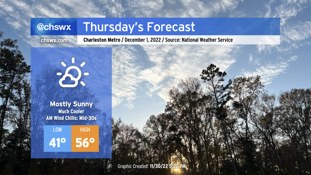
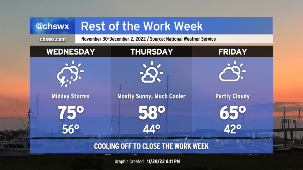
A cold front will swing through tonight, ushering in a cooler and drier airmass for Thursday. We’ll start the day in the low 40s, but gusty post-frontal winds will make it feel closer to 35°. Cold advection will keep afternoon high temperatures pinned into the mid-50s at best despite nearly full sunshine. A few clouds will develop late as a coastal trough begins to take shape, but other than that, expect a rather bright Thursday.
Our next rain chance arrives tomorrow as a strong cold front moves through the area. Expect a band of showers and maybe a few rumbles of thunder to roll through the area roughly from sunrise to mid-afternoon. (Exact timing of these lines can be a bit of a challenge, hence the range.) While wind shear will be decent, instability will be sorely lacking, and so there’s very little concern for any severe weather from this system (unlike what folks in Louisiana and Mississippi have seen this evening). We won’t get a whole lot of rain this go-around, either — generally expect a tenth to a quarter-inch of rain, with slightly higher amounts around I-95 and points west. Temperatures will jump into the mid-70s early in the day with warm air pumping into the area ahead of the front.
Said front will lag the rain by a few hours, but it should get through around or after sunset Wednesday, yielding a much cooler day on Thursday. Expect highs in the upper 50s on Thursday despite almost full sunshine. It’ll be a little breezy, too, so you’ll want the hoodie or light jacket.
Temperatures rebound a little on Friday after starting in the low 40s. We’ll see highs top out in the mid-60s with a few more clouds in the area, but still plenty of sunshine and a little lighter winds to enjoy a nice Friday outdoor lunch. From there, the 70s return and hang around for a few days through the weekend into early next week — not exactly the most December-like way to start December, but that’s how things go around these parts.
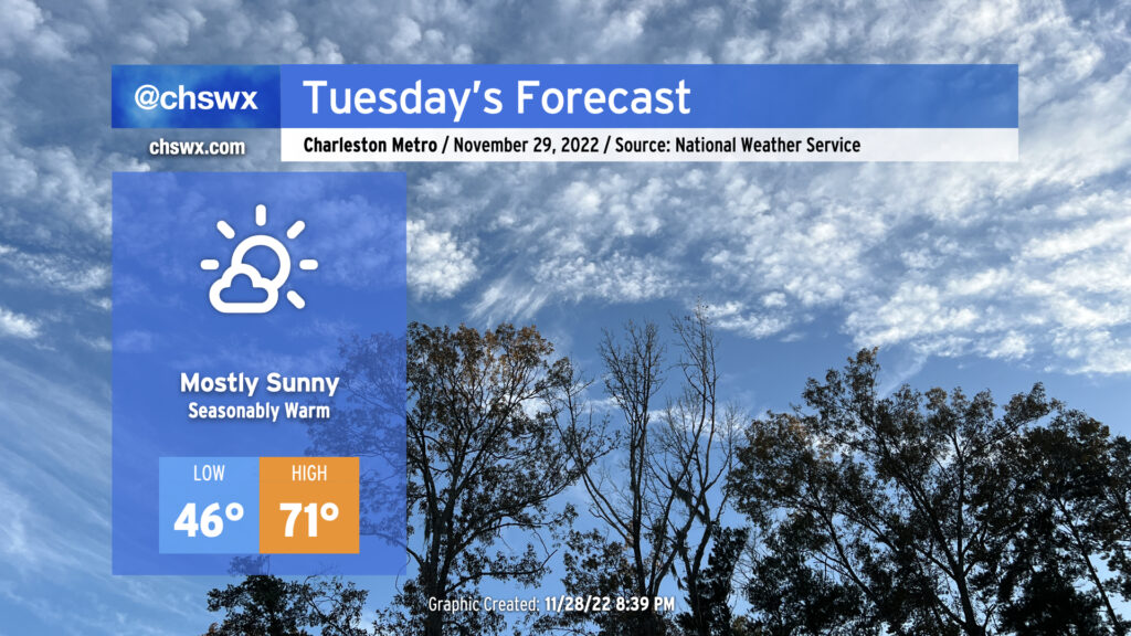
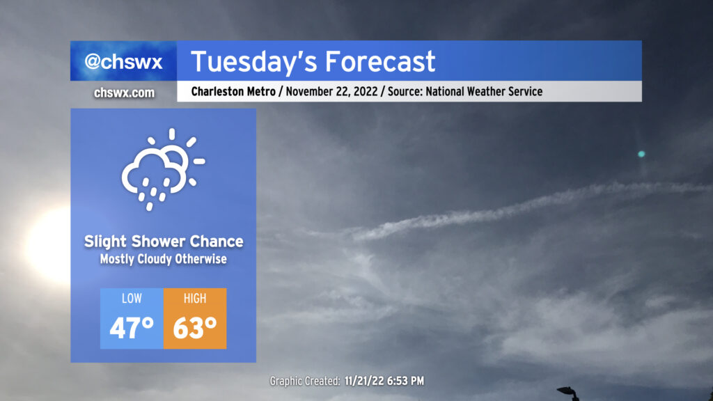
Quiet weather continues for Tuesday before rain chances return for Wednesday as a cold front comes through. Temperatures on Tuesday start around normal in the mid-40s and will rebound nicely into the low 70s in the afternoon. Winds will be calmer, making that outdoor lunch a little easier, too. Overall, no complaints for Tuesday (weather-wise, anyway).
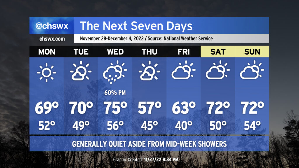
Aside from some showers on Wednesday as a cold front moves through, this week looks pretty good weather-wise, offering up more in the way of sunshine than we’ve seen in the past couple weeks.
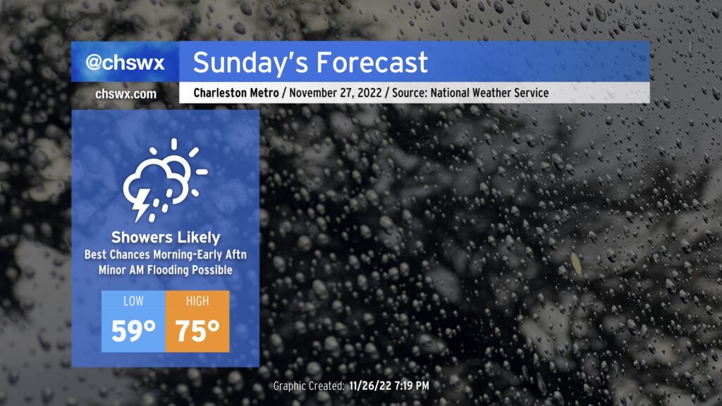
A storm system will approach the area overnight into Sunday, bringing another round of rain chances to the area primarily tomorrow morning into early afternoon.
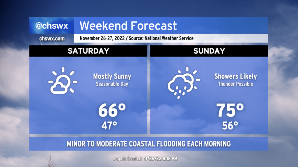
We get a good break from the gray skies on Saturday as we find ourselves between storm systems. The lull will bring us a nice, seasonable day, with lows in the mid-40s followed by highs in the mid-to-upper 60s, right in the ballpark for where we should be at this point in the year. The only fly in the ointment will be the risk for minor to moderate salt water flooding around the 9:29am high tide.
Clouds build back up Saturday evening as the next storm system makes its approach to give us another round of rain for Sunday. A warm front will lift north across the area throughout the day, allowing temperatures to top out in the mid-70s despite showers and maybe a thunderstorm or two in the area. The best chance for rain will be in the morning through the early afternoon hours. Expect the front to get through by evening, which will shut off the rain and dry out the air. Winds will be a little breezy with sustained winds approaching 20 MPH with higher gusts.
Sunday will mark the end of this king tide cycle, with minor flooding possible with the 10:28am high tide. A few downpours will be possible with the storm system moving by on Sunday, and we’ll want to watch for any to coincide with the mid-morning high tide.
Improving weather returns to start the new work week; the next shower chance will be mid-week, followed by seasonable temperatures to start December.
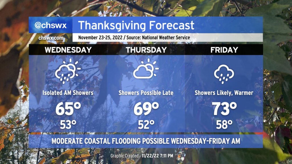
I hope everyone had a great Thanksgiving Day! The next few days will be a “sunshine sandwich” — overcast and rain, followed by mostly sunny skies, followed by another round of overcast and rain. We will also continue to contend with coastal flooding with the morning high tides through Sunday.
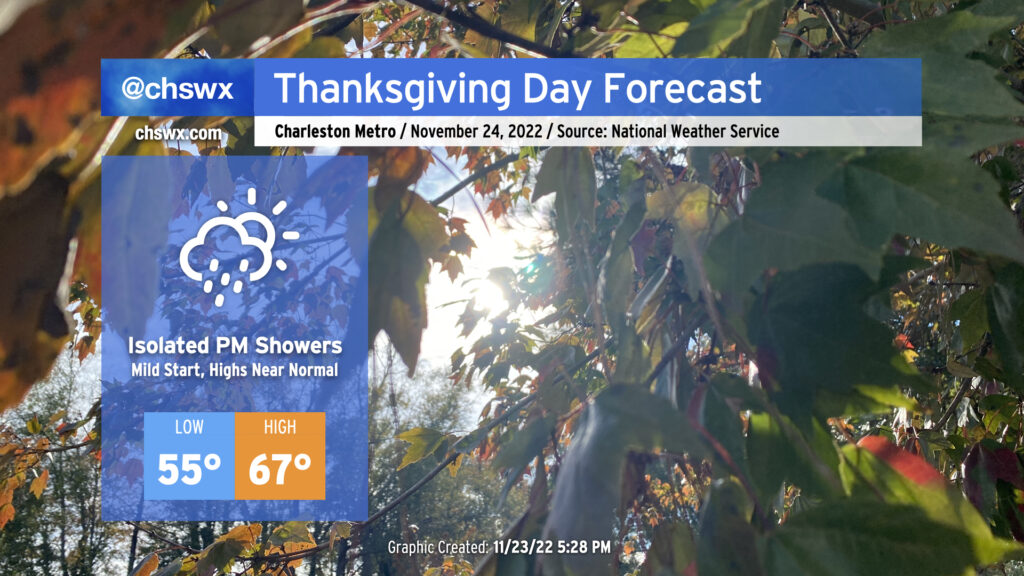
We have a relatively mild Thanksgiving Day ahead as temperatures start in the mid-50s, about 10° above normal for this point in the year. Pesky cloud cover will remain pesky with the coastal trough lingering offshore, and a few showers will be possible before rain chances increase further after sunset as more moisture makes its way ashore. Overall, don’t be surprised to dodge a shower or two, but I suspect that a lot of us get a majority of Thanksgiving in rain-free.
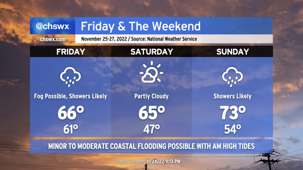
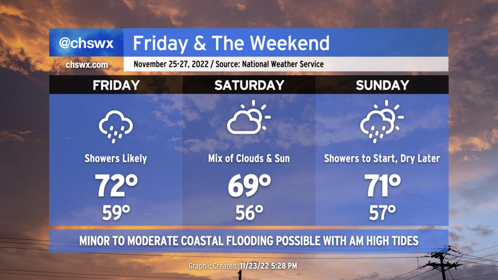
Friday & the weekend: Periods of showers with a nice day in the middle
Shower chances will peak on Friday as a warm front moves by followed by a cold front moving in from the north overnight. Lows will approach 15° above normal with cloud cover and a moist airmass in place. The warm front will help temperatures reach the low 70s in the afternoon despite shower activity that’s expected to be in the area. (A thunderstorm can’t be ruled out, either.) These showers will work their way out of here overnight with the aforementioned cold frontal passage.
Saturday should remain mostly dry with a mix of clouds and sun remaining in place. Temperatures will once again bottom out around 10°+ degrees above normal for another mild start followed by highs running right around 70° in the afternoon.
Showers return to the forecast Sunday as another cold front moves by the area. Once again, highs in the low 70s will follow a seasonably mild start to the day in the mid-50s. We should see showers begin to decrease later in the afternoon, paving the way for a cooler, drier, and sunnier Monday.
Coastal flooding remains a concern with morning high tides
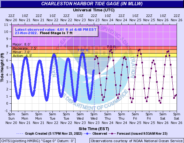
This morning’s high tide peaked around 7.02′, which scraped minor coastal flooding thresholds. Expect additional rounds of minor to moderate salt water flooding around times of the morning’s high tide through Thanksgiving and the long weekend. High tide on Thanksgiving morning is forecast to peak around 7.5′, or moderate flood stage, around 7:43am. We should see similar results from Friday morning’s high tide which is predicted to peak around 8:34am. Minor coastal flooding is forecast for Saturday morning’s 9:29am high tide, while guidance indicates another round of flooding will be possible for Sunday morning’s 10:28am high tide. Stay tuned for Coastal Flood Advisories from the National Weather Service.
Temperatures will continue on a warming trend as we head through Thanksgiving into the weekend. We’ll see periods of unsettled weather, too, but nothing too heinous to write home about.
Cloud cover moving over the area tonight will make for a much warmer start to Tuesday than we saw on Monday, with lows only dipping into the mid to upper 40s. Wakeups will trend even warmer as we get into the rest of the week, with lows in the 50s becoming commonplace through the weekend.
Keep an eye out for a few showers during the day on Tuesday as a coastal trough develops. Otherwise, expect temperatures to top out in the low 60s under mostly cloudy skies.
There will be a risk for a little salt water encroaching on roads around Gadsden Creek (Hagood/Fishburne/Lockwood) around the 6:10am high tide, but more significant flooding is not expected as water levels are expected to peak just shy of the 7′ coastal flooding threshold in Charleston Harbor.