Jared Smith founded @chswx on Twitter in 2008 as an experiment in disseminating weather data through social media. In the ensuing decade-and-a-half, @chswx has provided live coverage of tropical cyclones, tornadoes, severe weather, and even a couple bouts of winter weather to the good people of Charleston, SC.
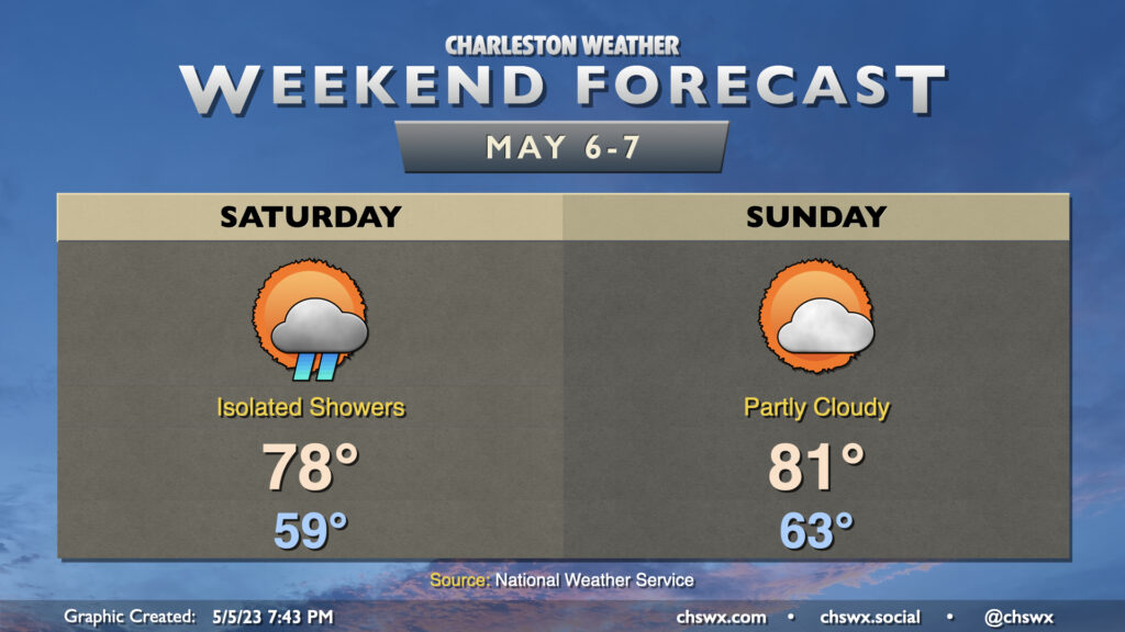
This weekend, while not completely clear of rain chances, doesn’t look half bad. Guidance trends toward a drier weekend have continued today, and it looks like we get just a few showers on Saturday and then partly cloudy skies on Sunday. High pressure moving offshore will pump in warmer and more moist air, leading to the shower potential Saturday. Highs top out only in the upper 70s, though, due to a decent amount of cloud cover throughout the day. We’ll see that cloud cover begin to break heading into the evening, though, and it should be a fairly nice end of the day.
Partly cloudy skies will be the rule Sunday. We’ll start the day in the low-to-mid-60s — much warmer than we’ve felt recently — and highs will top out in the low 80s in the afternoon. Dewpoints will be higher than they have been, but it’ll still be fairly comfortable at peak heating with relative humidity values below 50%. Overall, not the best weekend we’ve had, but not the worst, either. Even still, though, it looks likely that we will continue the streak of weekends with measurable rainfall dating back to early February.
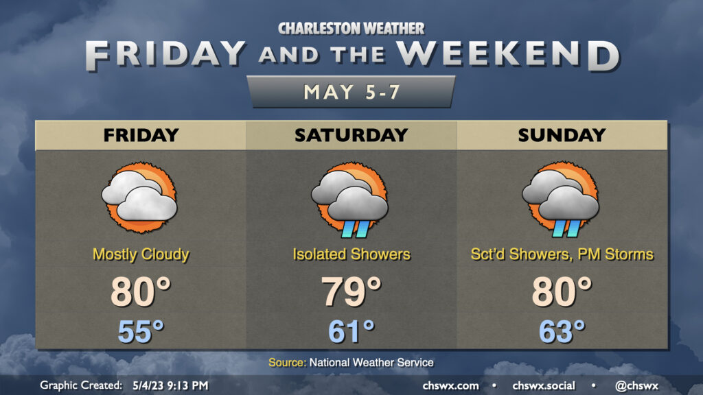
Allow me to revise the list of life’s inevitabilities as of 2023: Death, taxes, and shower chances over the weekend. A slow-moving front will be the latest culprit, keeping isolated to scattered showers on our mind each day this weekend. (It’s worth noting, though, that a total washout is not expected!)
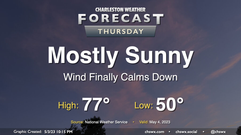
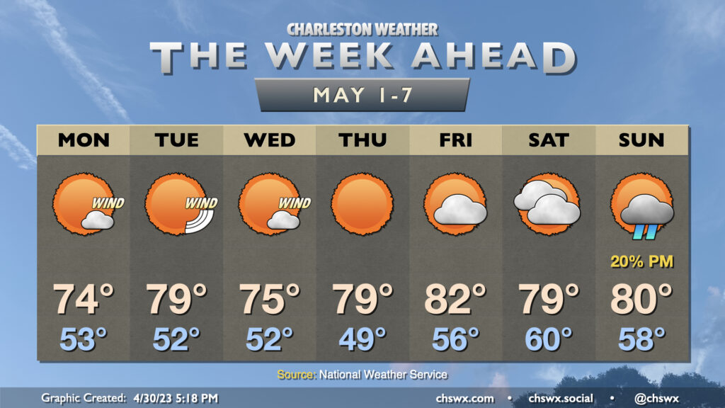
Thursday will represent the peak of our stretch of nice weather for one main reason: the pressure gradient that has kept our winds elevated for several days will finally have relaxed, bringing winds down to a light breeze during the day. Otherwise, it’s a carbon copy of Wednesday: Lows around 50°, with highs in the mid-70s in the afternoon under mostly sunny skies. I hope you can take advantage!
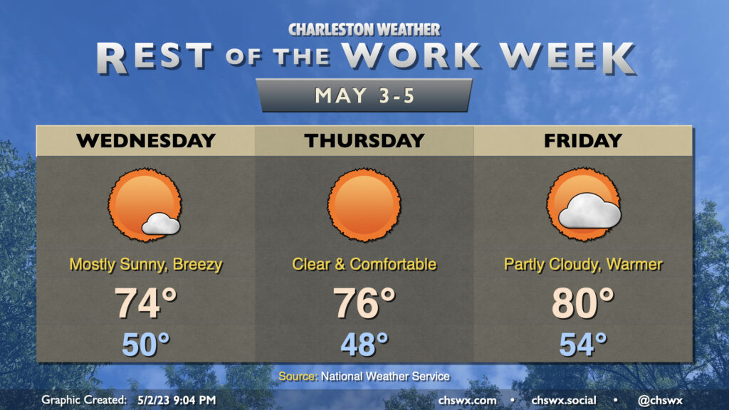
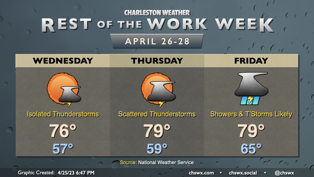
The rest of the work week will continue with plenty of sunshine and below-normal temperatures. We’ll start in the upper 40s to around 50° on Wednesday before temperatures only get up to around the mid-70s despite nearly unfettered sunshine. It will feel quite nice outside, but you’ll still want to mind the breeze that could push 20 MPH at times with higher gusts.
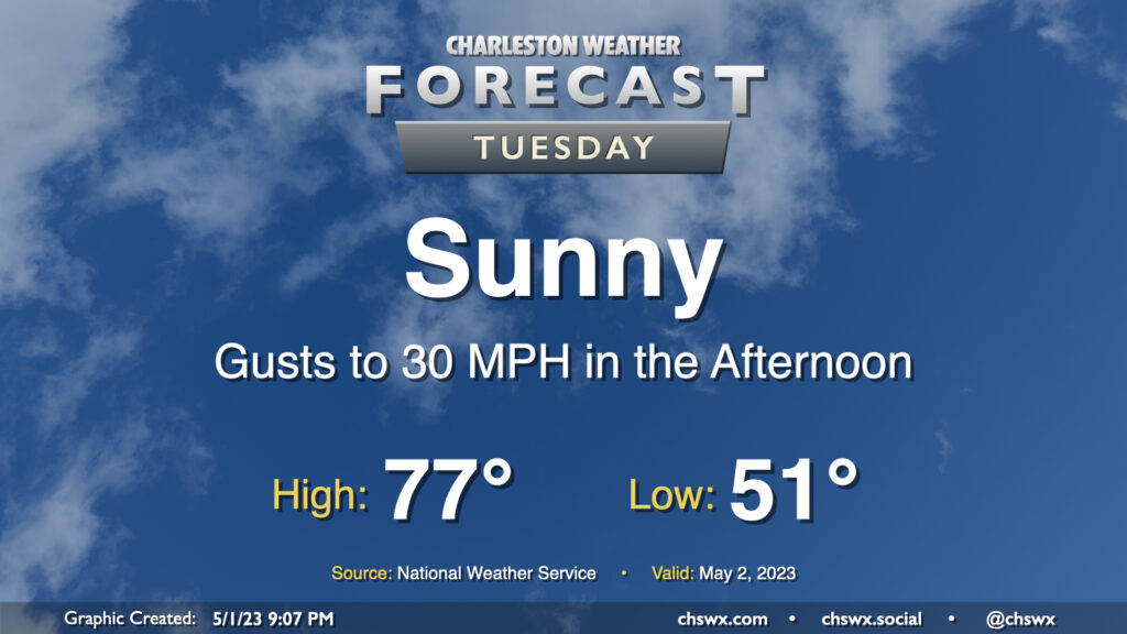
Tuesday looks fantastic by most objective measures — lows in the low 50s followed by mid-70s in the afternoon with plenty of sunshine. The only fly in the ointment remains the elevated wind gusts that will come along with peak heating in the afternoon thanks to deep mixing of the near-surface air that will tap into some elevated winds aloft. That’s about it, though — will be another pretty day with temperatures that at the end of this month I suspect we’ll wish we had back.
May will be getting off to a fairly windy start as a tight pressure gradient features prominently across the Southeast to start the work week. (At least we get comfortable temperatures and sunny skies!)
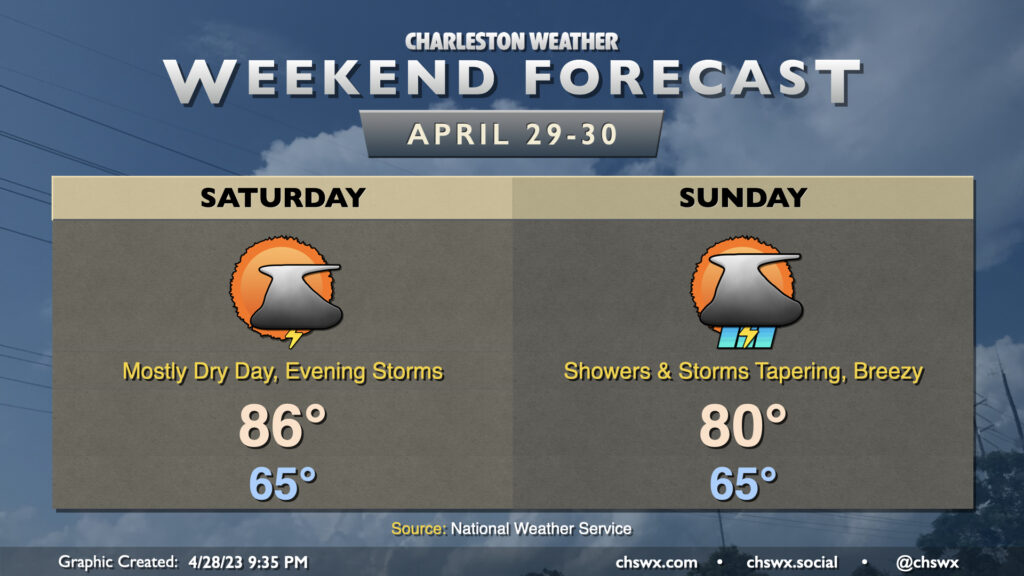
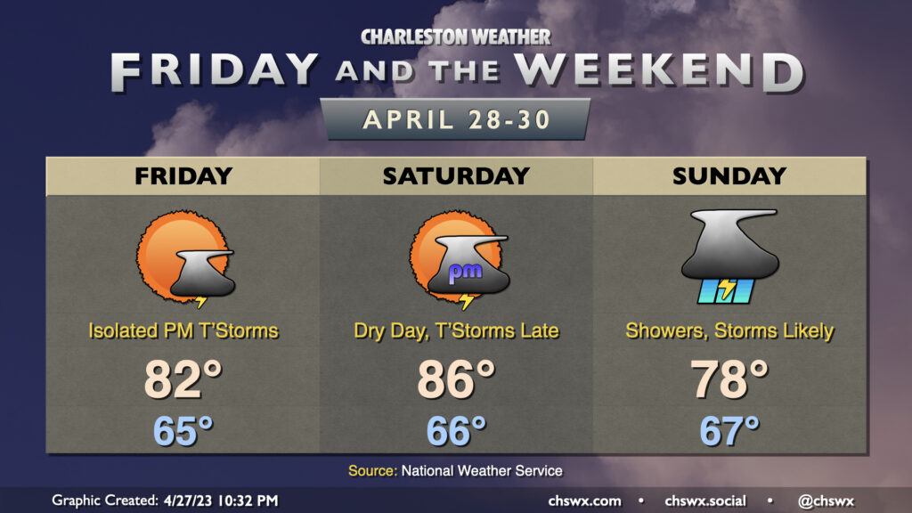
Saturday looks to be a fairly warm and muggy day — a tiny sliver of a summer preview — as we start the day in the mid-60s and top out in the mid-80s in the afternoon. We’ll stay rain-free for much of the day before a cold front and an accompanying upper low starts to get closer to the area. Shower and thunderstorm chances will subsequently increase, and a strong to severe storm isn’t totally off the table later Saturday given sufficient shear. Some heavy rain will be possible overnight and into early Sunday morning as well, with local amounts possibly exceeding an inch of rain before it’s over.
Showers and storms look to be ongoing as we head into Sunday morning, but will taper off as the day goes on as low pressure lifts northeast and the aforementioned cold front moves through. By Sunday evening, we should be largely rain-free and cooling off as a drier airmass builds into the area post-frontal passage. Highs top out around 80° in the afternoon. Winds will be elevated, with gusts 25-30 MPH possible particularly as we get into the afternoon hours as the mixed layer rises to around 6,000 feet, tapping into a decently strong low-level jet, which will hang around for the subsequent few days to provide a gusty start to May.
So one thing you’ll notice out of the gate with Friday’s forecast is that it looks a lot less stormy. This is due to the batch of rain pushing through as of this writing on Thursday evening; once this is through in the early morning, we’ll be in a lull in the more widespread activity, it looks like. Isolated to scattered thunderstorms remain possible, though, particularly further inland. The atmosphere will be primed for some sporadic severe weather if storms can fire given sufficient instability and shear, with damaging winds and hail the main concerns. However, the if in the previous sentence is pretty loaded — some models show very little if any rain during the day Friday. We’ll want to wait and see, and I’ll encourage you to stay weather-aware in case storms threaten, but overall the forecast looks a lot less soggy than it has for a good bit of the week. Highs will top out in the low 80s after starting the day in the mid-60s.
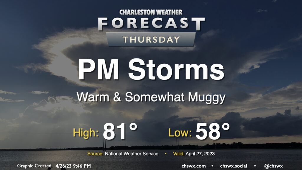
We should get a fair bit of Thursday in rain-free, but changes will be coming later in the day as low pressure to the west approaches the area. We start one more morning in the upper 50s before a warm front gradually lifts through the area throughout the day, which will bring dewpoints up in the afternoon and put a little mugginess in the air. A shower or storm along the seabreeze in the afternoon and early evening can’t be totally discounted, but the bulk of the rain arrives after dark with the aforementioned low pressure and will be around for much of the overnight.