Jared Smith founded @chswx on Twitter in 2008 as an experiment in disseminating weather data through social media. In the ensuing decade-and-a-half, @chswx has provided live coverage of tropical cyclones, tornadoes, severe weather, and even a couple bouts of winter weather to the good people of Charleston, SC.
Thursday continues where today left off, with a seasonably cool morning followed by a comfortably warm afternoon in the upper 70s, right where we should be at this point in April. Humidity will be low once again as dewpoints mix out into the low 40s, yielding relative humidity values approaching 25% during the peak of the afternoon. It’ll be another good day for an outdoor lunch or evening walk as a result — just make sure you’ve got some sunscreen!
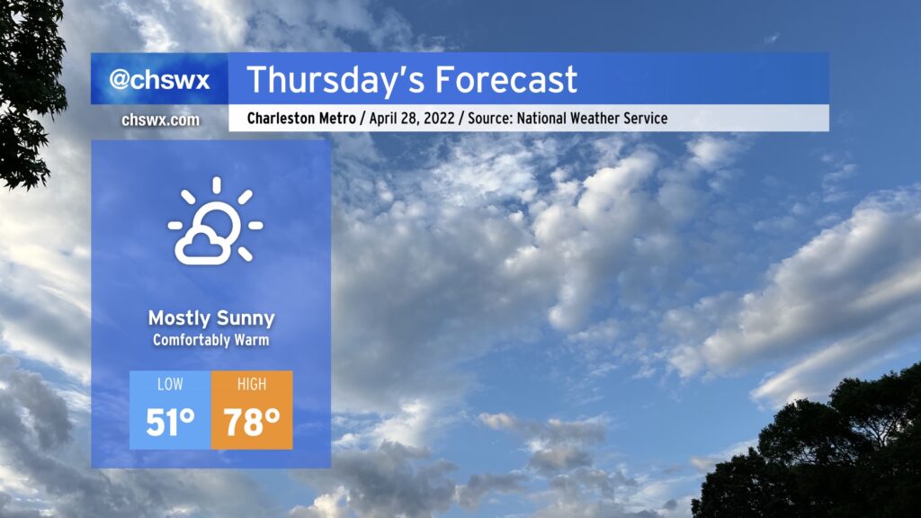
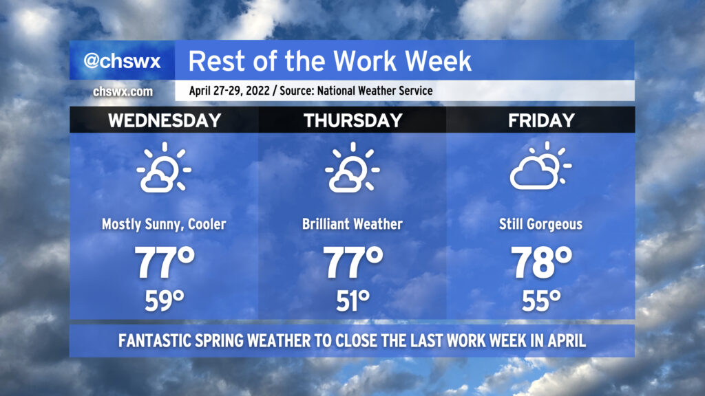
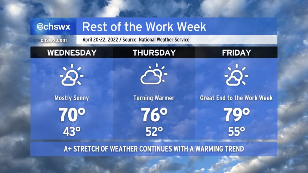
After a cold front gets through tonight, we’ll see another round of cooler and drier air move into the area to set up a fantastic finish to the work week. Temperatures will run around 10° cooler tomorrow afternoon with plenty of sunshine — an excellent day for outdoor lunch, getting some walking in, or however you wish to be outside. This continues into Thursday, which will be another brilliantly beautiful day with highs once again topping out in the mid-70s. We’ll start to see a little bit of a warming trend commence on Friday as high pressure moves offshore, sending winds more southerly. Still, it’ll be another really nice day with lows in the mid-50s and highs in the upper 70s. The warming trend continues into the weekend, with highs in the low 80s on Saturday and in the mid-80s on Sunday. Enjoy!
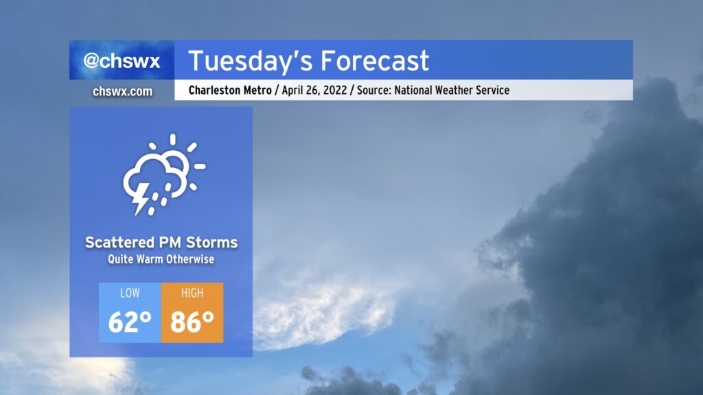
We have an even warmer day on tap for Tuesday before storms move in late in the afternoon into the evening ahead of a cold front. We’ll start the day in the low 60s before temperatures head to the mid-80s away from the cooler coastline. The warmest it’s been so far this year is 86° on February 23rd and again on February 25; we should tie this tomorrow. (The daily record high of 92°, set in 1989, is safe.)
We’ll be watching a cold front move into the area throughout the day Tuesday. Scattered showers and thunderstorms are expected to develop ahead of this front, with brief periods of heavy rain and gusty winds the main concern. There’s a low risk that a storm could produce a damaging wind gust or two, but severe weather doesn’t look to be a big concern with tomorrow’s front.
Rain should clear the area with the front by daybreak Wednesday, leaving behind cooler, drier air and overall pleasant weather for the next couple days. High pressure shifts offshore thereafter, and a warming trend will commence heading into the weekend. We could be in the mid-80s again by Sunday with a slight storm chance to go with it. Overall, though, quiet weather remains the rule as we head into the second half of the week.
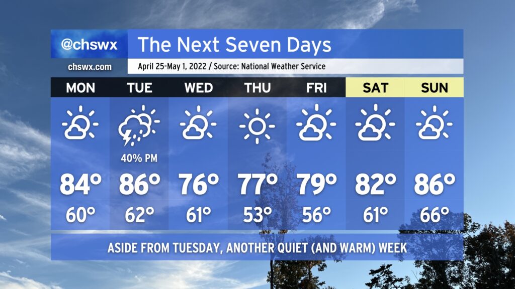
Another mostly nice-looking week lies ahead to close out April, a stark contrast to how this month got started. We start the work week as warm as we’ve been thus far in 2022, with highs topping out in the mid-80s on Monday and Tuesday ahead of a cold front. The only rain chance will be a shot at some showers and thunderstorms Tuesday afternoon and evening as the front passes by. These don’t look like they’ll be terribly organized, keeping the severe threat to a minimum.
Once the front is through overnight Tuesday into early Wednesday, we’ll see temperatures cap out around the mid-70s Wednesday and Thursday afternoons with very few clouds to speak of. A warming trend commences in earnest Friday as high pressure begins to slip back offshore, and we may very well start May off on a warm note on Sunday with highs in the mid-80s.
Overall, we largely continue to be spoiled by great weather (though we could still use some more rain given the ongoing drought). Enjoy!
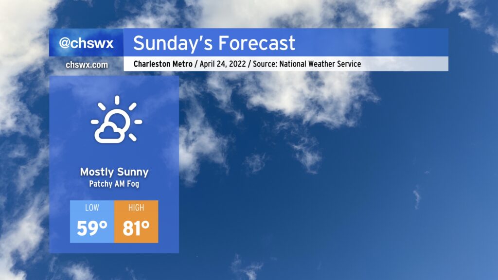
We have another warm — and even slightly muggy — day ahead of weather as temperatures head back into the low 80s once again. Onshore flow will help keep dewpoints somewhat elevated, putting a touch of muggy into the air, but it’s nothing terribly out of the ordinary for this point in the year. We may contend with some patches of fog in the morning, but these should mix out shortly after sunrise.
One potential fly in the ointment to this forecast is something we saw this morning and could repeat itself tomorrow: the risk for a very isolated shower. The convection-allowing models have a few areas of low-end reflectivity coming ashore between 8am-12pm. This is likely the model depicting a somewhat more agitated cumulus field within an area of low-level convergence on the periphery of the surface high. However, I bring it up because this morning’s cumulus field did, in fact, toss some raindrops on me as I was doing my morning walk. So, we’ll see. All that said, though, if you see a raindrop or two tomorrow, don’t be totally surprised, then go buy a lottery ticket. It might be your lucky day.
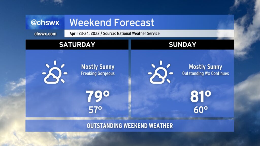
Liked today? Good, because we have more of that coming up this weekend as high pressure remains in firm control of our weather. We’ll see some clouds from time to time, but other than that, expect widespread sunshine across the region and seasonably warm temperatures around 80° both days (cooler near the coast). Pack the sunscreen if you’re going to be outside!
Looking ahead, temperatures will turn even warmer to start the work week. Tuesday could feature the warmest temperatures we’ve seen this year, reaching or even topping late February, when we hit 86° on the 23rd and 25th. Rain chances return for mid-week, but that looks to depart in time for next Friday, too. Can’t get mad at that.
It’s going to be a pretty amazing weekend of weather, folks. Temperatures will return to the 80s as ridging continues to build aloft, and clouds will be at a minimum as high pressure rebuilds at the surface. The only weather concern I’d have is sunburn! Use sunscreen if you’re out and about, especially if you’re putting in a couple days at High Water Festival this weekend. Enjoy the excellent stretch of spring weather! We’ll stay dry through at least Monday before our next rain chances enter the picture later Tuesday.
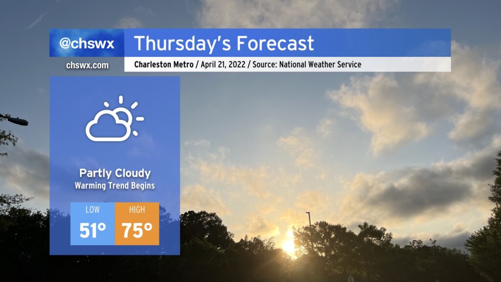
After another cool day by mid-April standards, we return to the 70s on Thursday as surface high pressure shifts offshore and we begin to see ridging start to build in aloft. We’ll have a few more clouds than we’ve seen in previous days with a little more available moisture, but they will be benign and non-precipitating.
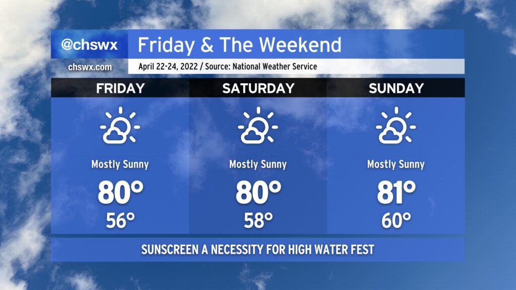
No complaints in this forecast: Plenty of sun will continue as temperatures embark on a warming trend as the work week progresses. Temperatures on Wednesday will start out rather chilly by April standards, dipping into the low 40s in the metro and possibly into the upper 30s further north into rural locations. Not expecting frost to become an issue, though. After a high of 68° today, highs will top out a touch warmer, likely around 70°. Skies will be mostly sunny once again, belying the cool airmass which remains in place.
A warming trend then commences on Thursday as high pressure slips a bit offshore. This will bump highs into the mid-70s, much closer to where we typically find ourselves in mid-April. There will be a few more clouds with moisture coming in off the Atlantic, but that will just make the skies a little more interesting to look at. High pressure retreats back to the west a little bit for Friday, clearing skies a bit. More notably, though, we’ll see high pressure begin to stack aloft, allowing for temperatures to warm even more noticeably into the upper 70s to around 80° for Friday.
The great weather continues into the weekend, too, with highs topping out in the low 80s each afternoon as high pressure remains the dominant feature at the surface and aloft. It’s great to be able to say that there are absolutely no weather concerns for High Water Fest this year! (Well, other than that you’ll definitely want sunscreen.)
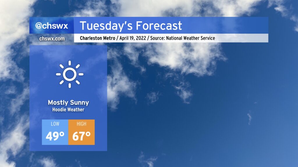
A cold front will continue to press south of the area this evening, clearing things out and cooling things off to kick off a stretch of pleasant weather. We’re gonna be pretty chilly to start this stretch off, though — lows Tuesday morning will dip into the upper 40s, but more notably, highs will only top out in the mid-to-upper 60s despite clear skies.
This chill will continue into Wednesday morning, with mid-40s lows a good bet in the metro area (trending even cooler in more rural areas). The trend will be warmer from that point forward, though, and before you know it we’re back in the 80s for Friday and the weekend.
Rain-free conditions will continue throughout the rest of the week into next Monday. Peeking ahead, it may not be until Wednesday before we start to see some showers work back into the forecast. Stay tuned for that, but in the meantime, enjoy the nice stretch of weather!