Jared Smith founded @chswx on Twitter in 2008 as an experiment in disseminating weather data through social media. In the ensuing decade-and-a-half, @chswx has provided live coverage of tropical cyclones, tornadoes, severe weather, and even a couple bouts of winter weather to the good people of Charleston, SC.
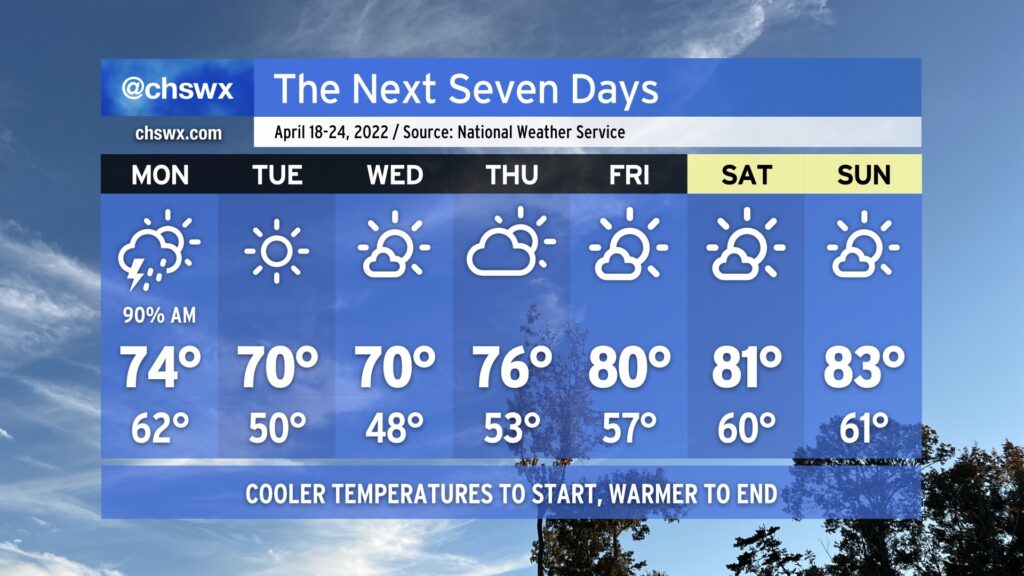
The work week will certainly get off to a meteorologically inauspicious start: Showers and thunderstorms will be ongoing from overnight Sunday heading into Monday morning. Heavy downpours will certainly be possible, so you’ll want to make sure you’re allowing extra time to get where you’re going in the morning. (You know how it gets around here when it rains.)
The bulk of the rain heads offshore by midday, but the short-range and convection-allowing models allow the atmosphere to recover some before the cold front gets through. This is kind of tricky as a high pressure wedge will be trying to build southward at the same time, and models are notorious for under-doing this. I wouldn’t rule out an additional shower or storm forming in the afternoon hours, but that’ll be highly conditional on just how much the atmosphere recovers before the front gets offshore, which is expected generally around mid-afternoon.
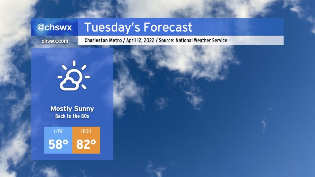
From there, though, the week turns nice and tranquil. Tuesday and Wednesday will run much cooler than normal for mid-April as highs only top out around 70° each day despite full sunshine. Ridging will develop aloft thereafter, allowing temperatures to warm into the mid-70s on Thursday and back into the 80s for Friday and the weekend. All the while, we look to remain rain-free given the firm control high pressure will have over our weather at the surface and aloft.
The only potential fly in the ointment will be the risk for minor coastal flooding late Monday night, when high tide around 10-11 PM looks to peak in the 7.2-7.4’ range. Thereafter, though, the effects of the new moon and perigee diminish, bringing a quick and merciful end to this round of coastal flooding.
We’re looking at another unsettled day for Easter Sunday as a cold front sinks south of the area, stalls out, and disturbances ride atop it to generate more showers and thunderstorms, especially during the evening hours.
We could have some showers in the area on Easter morning, but these should be relatively tame and not drop too much in the way of rain (though a downpour can’t be ruled out particularly as we get later into the morning). It’ll start out warm and muggy, with lows only getting into the mid-60s. A front will push southward across the area during the morning, as well, marked by winds shifting to the northeast. This will limit temperatures to the mid-70s at best.
The better rain chances will arrive later in the afternoon into the evening with another disturbance swinging through. We could see some substantial rain from this round, with some spots potentially seeing up to 1-2” of rain. This rain will persist overnight and into Monday, as well.
One thing we will need to watch very closely for late Sunday: Tides. With winds turning northeasterly and the ongoing perigee, water levels could approach moderate flood stage with the 9:37 PM high tide. If heavy rain is in the area leading up to or during these high tides, we will almost certainly see some decent flooding in parts of downtown Charleston. Not a given yet, for sure, but something to watch very closely to see if things line up.
If you’re celebrating, I hope you have a happy Easter!
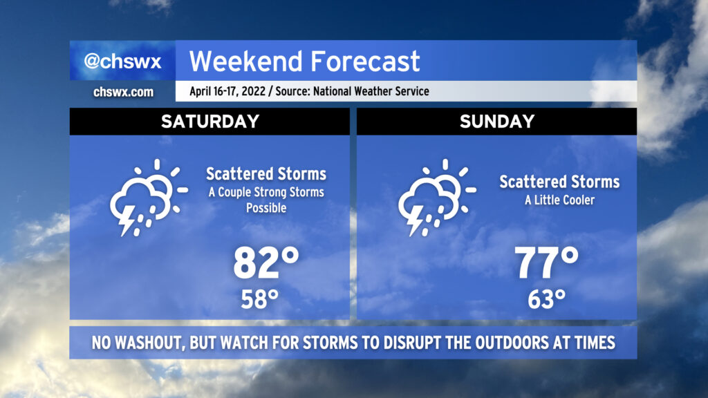
After a gorgeous (if not a bit windy) Friday, a warm front will lift northward across the area on Saturday, bringing warm and moist air back into the picture. This will be the fuel needed for some scattered showers and thunderstorms as a disturbance aloft ripples through the area and helps to kick off and sustain storms in conjunction with an inland-moving seabreeze. A couple storms could be on the strong side with gusty winds and hail, so keep an eye out if you have outdoor activities. A widespread severe weather event is not anticipated, though.
Temperatures on Saturday start in the upper 50s but rebound well into the low 80s after the warm front moves by.
Sunday will continue to feature scattered storm chances as upper-level energy continues to move through the area and a front stalls out nearby. We’ll run a touch cooler behind the backdoor front, with highs topping out in the mid-to-upper 70s. A continued feed of moisture will allow the stronger storms to produce a heavy rain threat, which could lead to some minor flooding in poorly-drained and low-lying areas.
Even without rain, evening high tides will get high enough to cause some minor coastal flooding through early next week. Any rain on top of that would not be great, so we’ll want to keep a close eye on things.
Expect similar conditions on Monday with improving weather starting Tuesday into much of the rest of the next work week.
A series of cold fronts will make for a bit of an unsettled forecast heading into the weekend. A washout is not anticipated, though.
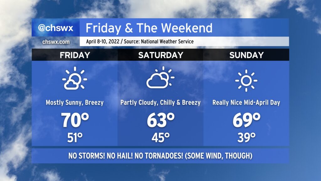
Said front will come through sometime Friday morning, clearing out any shower activity from overnight. Cooler and drier air will punch into the area, setting up a rather nice day for many of us as highs peak in the mid-70s under partly to mostly sunny skies. It’ll be breezy, though, with gusty winds possibly approaching 30 MPH at times according to NWS. Keep this in mind if you decide to have lunch outside!
Unsettled weather returns Saturday as moisture return improves across the area and mid-level disturbances pass on by. These disturbances should kick off some scattered showers and some thunderstorms across the area, particularly in the afternoon. Ahead of thunderstorms, temperatures will top out in the low 80s across the area with the more warm and moist airmass returning to the area.
Sunday, another cold front will stall out across the area and another disturbance will ripple overhead. This will bring another round of scattered showers and maybe some thunderstorms to the area. Temperatures will run noticeably cooler behind the second front with highs only topping out in the mid-70s in the afternoon.
The good news in all this is that no severe weather is anticipated — getting the rain without all the other stuff is a win for our still-parched part of the world.
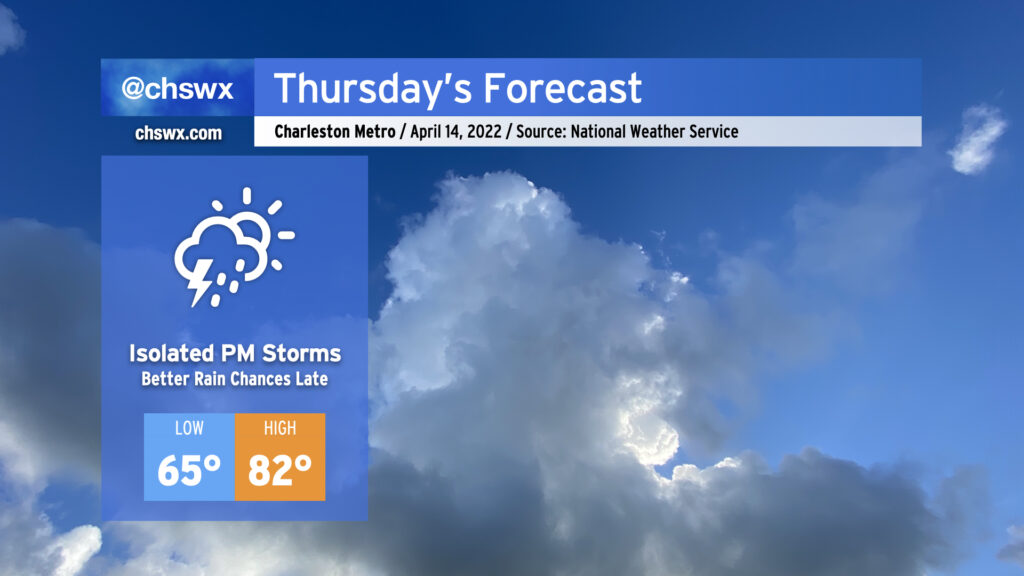
A cold front will approach the area Thursday, packing a (thankfully weaker) line of showers and thunderstorms that will continue to lose oomph as it trudges ever eastward. We should get a majority of the day in rain-free, with only slight shower and storm chances as we get later into the afternoon. Temperatures will rise into the low 80s despite the increased cloud cover. The better rain chances are pegged for later in the evening and into Friday morning, which you’ll want to keep in mind for dinner plans and beyond. Severe thunderstorms are highly unlikely in the Charleston metro area, with a low risk of severe weather around and west of I-95.
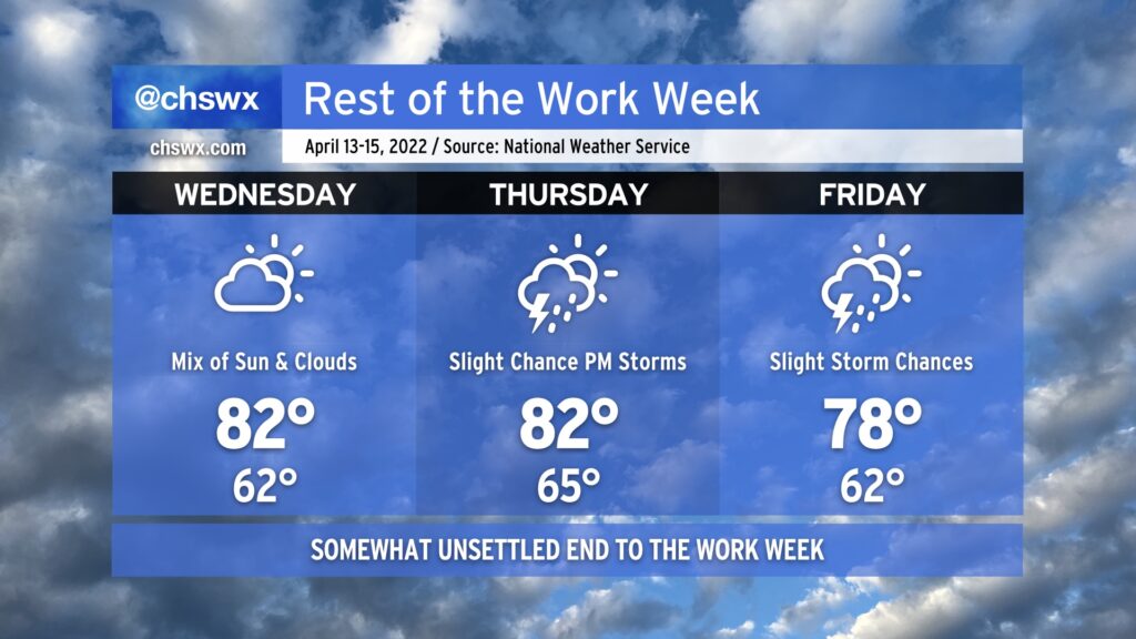
Warmer-than-normal conditions continue this week despite a weak front poking into the area on Friday. Temperatures will generally run in the low 80s Wednesday and Thursday, with slightly cooler and drier air on Friday behind the front.
Said front will usher in some shower and storm chances starting Thursday afternoon. The best chances of showers and storms will arrive overnight Thursday into Friday with the frontal passage. The front will stall out nearby on Friday, perhaps keeping a shower or storm chance in play across the Charleston metro during the day.
The severe weather threat looks very low and, at least as of right now, should stay generally west of I-95. Will keep an eye on it, but the ingredients look incredibly marginal. (I don’t think anyone’s complaining about this, either.) With the area remaining in drought even after last week’s rains, we’ll take what we can get — bonus points if it arrives without severe weather.
Peeking ahead toward the weekend, unsettled weather does continue to appear probable, but the models are disagreeing quite a bit on the details still. Temperatures should remain on the warm side of normal, though, through the weekend. Stay tuned as the forecast becomes more fine-tuned.
We’ve got another mostly sunny day in store for Tuesday. We’ll start the day about 10° warmer than we did today, bottoming out in the upper 50s as opposed to the 40s. Temperatures should reach the 80s away from places near the coast such as downtown or the islands, where we’ll run a few degrees cooler. The beaches themselves could run significantly cooler.
Quiet weather continues into at least Wednesday before a slight rain chance enters the weather picture Thursday as a front gets close to the area. On and off showers and storms will be possible thereafter, possibly through the weekend, as the front stalls nearby. The good news is that no severe weather is expected as the shear and instability parameters are solidly in the “meh” category, at least as far as the global models can resolve right now.
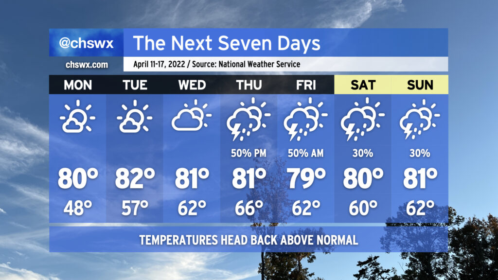
After a rather chilly weekend by mid-April standards in the Lowcountry — we only got to 58° on Saturday, one degree off the record low maximum — above-normal temperatures return to the picture for the week ahead as ridging develops aloft. We stay calm to start the work week, but unsettled weather re-enters the picture beginning Thursday and possibly lasts into the weekend.
Temperatures will take quite a swing on Monday — we’ll start in the upper 40s across the area on our way to 80° in the afternoon under mostly sunny skies. This will get Tuesday off to a warmer start — think mid-to-upper 50s — as we once again head back to the low 80s in the afternoon. Expect similar weather, save for a few more clouds, on Wednesday.
As we get into the second half of the week into the weekend, the upper-air flow becomes a little more zonal (blowing more straight west-to-east) as a trough digs in to our north. This should send a cold front into the area — but perhaps not through it — as we close out the work week, bringing along some shower and thunderstorm chances. Thankfully, the setup shows no signs of repeating the severe weather we experienced last week. Beyond there, model solutions are diverging a bit as far as the weekend goes, but some unsettled weather could be in the cards as we head toward Easter. Regardless, temperatures look to stay above normal through the weekend. We may yet head below normal again the following week, though, but that’s for another day.
A series of cold fronts will usher in a pretty unseasonably cool airmass for Friday and the weekend. Tonight’s front, which was responsible for another round of thunderstorms that produced hail across the metro area, will bring considerably cooler and drier conditions for Friday. After starting out in the low 50s, highs will top out no warmer than the low 70s with mostly sunny skies throughout the day. Winds will be a little breezy behind the front as cold air advects into the area throughout the day, but it’s nothing we can’t handle at this point.
A reinforcing cold front comes through Friday night/early Saturday morning, bringing some cloud cover along for the ride (but it’ll be too dry for precipitation). After starting the day in the mid-40s, highs will only top out in the low 60s — temperatures that are much more reminiscent of January than April in these parts. Sunday morning starts even cooler, with lows in the upper 30s in the metro area. We could turn even cooler than that further inland, and frost may become a consideration. Temperatures do rebound to near 70° under full sunshine, though.
Rain-free conditions will continue through to at least next Wednesday if not Thursday as temperatures warm back to the low 80s by the middle of the work week. Enjoy the break from wacky weather!
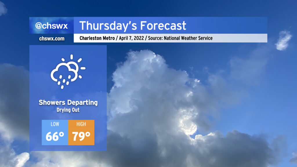
Thursday will start unsettled, but we will dry out as the day goes on as the cold front finally gets through the area, changing up the airmass and leading to a really gorgeous weekend. We will likely wake up to showers and maybe a few thunderstorms in the area; this could have some commute impacts, but no severe weather is expected. Showers will gradually scour out throughout the day and we should end with a fair bit of sunshine. Highs will top out around 80° ahead of the front; that’ll be as warm as we get until next week.
The weekend looks pretty great, if not downright chilly at times. I hope you haven’t stowed your hoodies, because you’re gonna need them Saturday as highs only top out in the mid-60s! The April sun angle will make that feel pretty good, though. Savor these days — not many more of them until we get into the dredges of summertime in the Lowcountry.