Jared Smith founded @chswx on Twitter in 2008 as an experiment in disseminating weather data through social media. In the ensuing decade-and-a-half, @chswx has provided live coverage of tropical cyclones, tornadoes, severe weather, and even a couple bouts of winter weather to the good people of Charleston, SC.
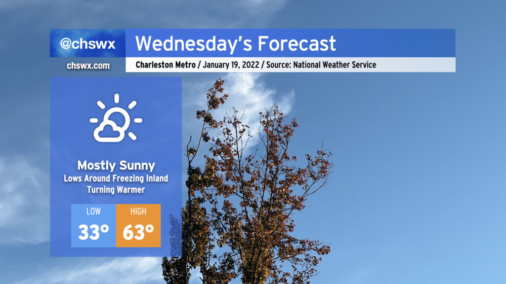
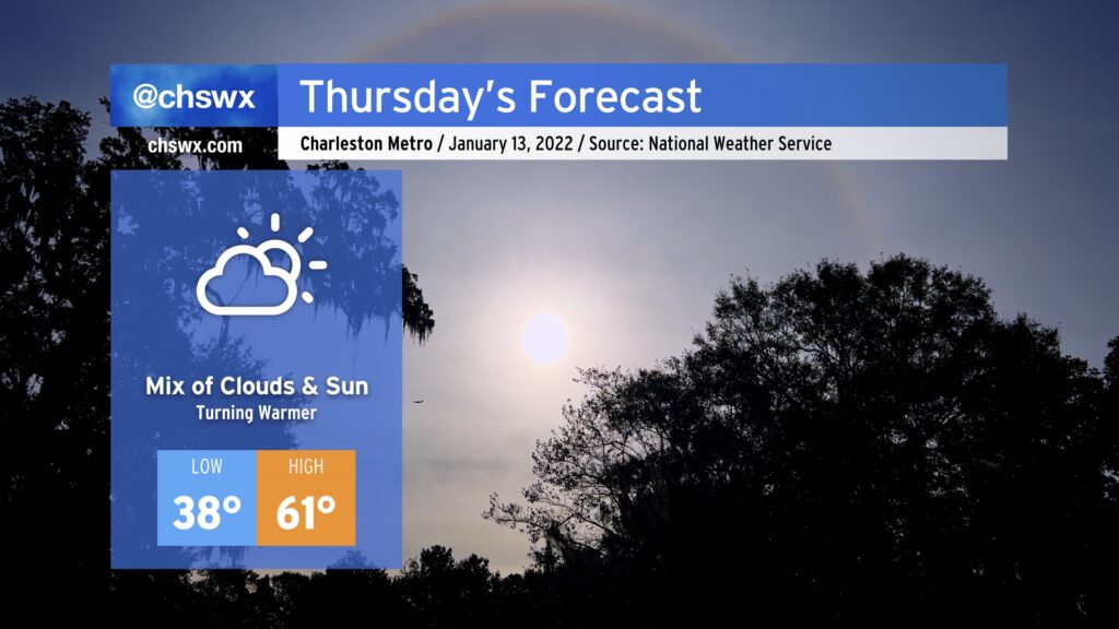
Wednesday’s weather looks pretty good. Temperatures will start out right around freezing — be sure pets and plants are protected once again tonight — with a nice warming trend up to the low 60s as high pressure slips offshore. All this will be under mostly sunny skies, with a few more clouds today than yesterday.
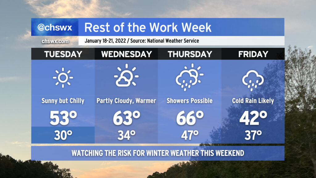
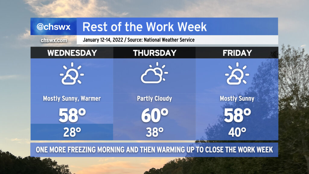
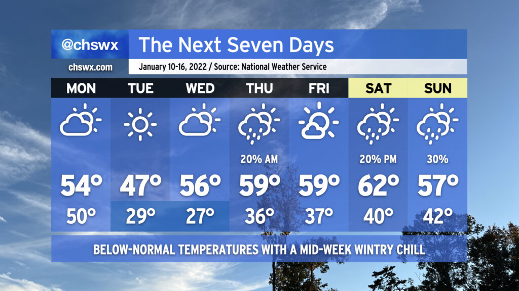
The temperature rollercoaster will continue as we head into the rest of this abbreviated (for some, anyway) work week. Tuesday will be sunny but still quite chilly as the cold airmass that this weekend’s storm ushered in stays put for another day. High pressure slips offshore Wednesday, though, allowing temperatures to warm up into the low 60s in the afternoon with a little bit more cloud cover working its way in ahead of a cold front. That front will get a little closer on Thursday and could begin to spread some showers into the area into the afternoon hours, but should stay far enough west to keep us in the 60s one more day.
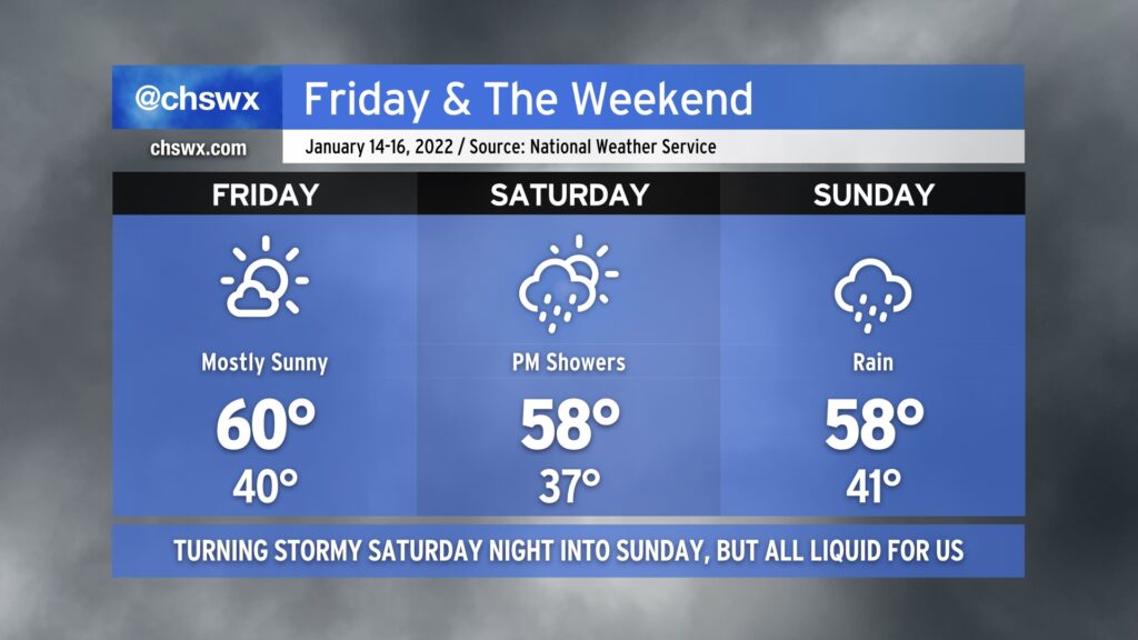
Then Friday rolls around, and the wheels come off in terms of forecast confidence. What is probable is that the front will keep some precipitation around on Friday, and temperatures will be significantly cooler behind said front. The NWS forecast highlights rain showers and highs in the low 40s for Friday as cold high pressure wedges southward. Beyond that, the forecast turns very tricky. Weather models continue to disagree on many of the details of what to expect this weekend, but the potential for at least a little winter weather is increasing. The GFS model has a double-barreled shot of mixed precipitation for Friday night and again over the weekend as it has low pressure developing near the coast and moving northeastward. The ECMWF (Euro) operational model generally shows the primary winter weather threat in the form of freezing rain on Friday night into Saturday followed by dry weather the rest of the weekend.
Suffice to say, it’s a tricky, tricky forecast with more questions than answers at the moment. There are many scenarios, including an all-rain scenario, that are very much on the table. I urge you to continue to monitor forecast updates throughout the week as the details continue to come together, especially with the potential for freezing rain to develop.
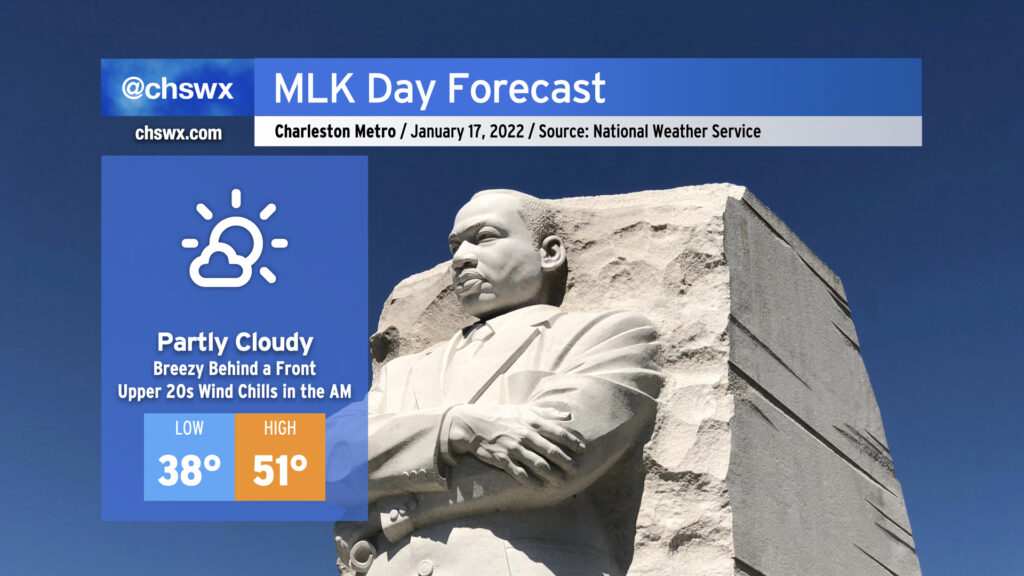
We’ll start Martin Luther King, Jr. Day out in chilly and breezy fashion as cold air moves into the area in the wake of today’s storm. Lows will bottom out generally in the mid-30s away from the coast, but gusty winds will make temperatures feel closer to the mid-to-upper 20s. A mix of clouds and sun will give way to fewer clouds and more sun by afternoon as high pressure continues to build back into the area. Despite the increasing sunshine, temperatures will still struggle into the low 50s as the colder airmass takes hold.
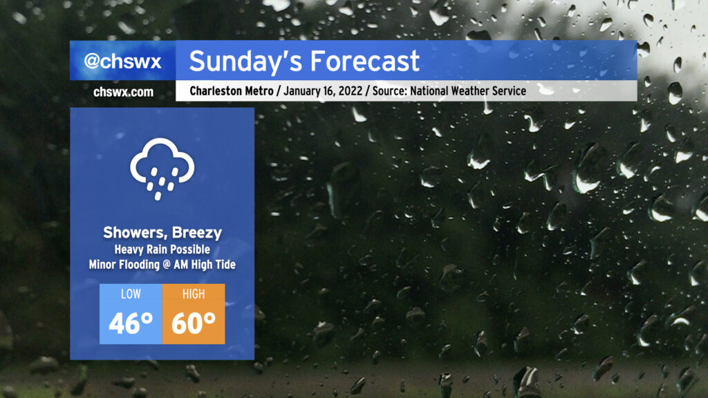
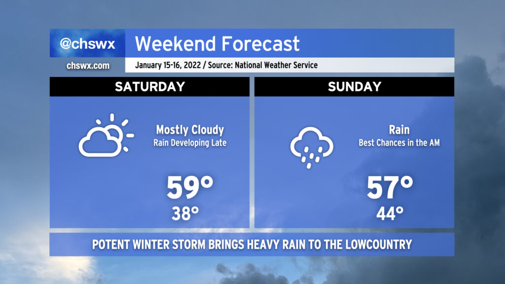
Rain will increase across the area by early Sunday morning as the potent storm system we’ve been watching for the last several days makes its approach to the Charleston area. 1-2″ of rain will likely fall before it’s all said and done Sunday evening. Gusty winds will be a concern especially as the cold front moves through, potentially bringing gusts 30-40 MPH at times especially on elevated surfaces.
Temperatures will remain above freezing for the duration across the Tri-County, and no winter weather is expected. The exact temperatures are going to be somewhat difficult to pin down as it will largely depend on how far inland a warm front can get. We could easily see highs in the low 60s at the immediate coast and temperatures struggling to get out of the 40s for much of the day around the Santee Cooper lakes and the I-95 corridor. Even though we’re now at the point where the highest-resolution models are able to resolve these features, it’s going to be really, really tough to say with much confidence exactly how the temperature curve will shake out tomorrow. The warm front will bear close watching.
Flooding is becoming an increasing concern for early Sunday morning as well. Water levels in the harbor are forecast to peak around 7.2′ with the 6:47am high tide, owing to strong northeasterly winds developing within the wedge as low pressure deepens to our west. Recent guidance suggests a non-zero possibility for a few heavy showers to be in the area around this time, too, so we’ll need to watch closely in case tides and rainfall combine for road flooding in downtown Charleston.
There is a non-zero risk for a thunderstorm or two near the coast during the day Sunday. However, conditions don’t look terribly favorable for severe weather in our neck of the woods. (There is a slightly better risk of severe weather as you head into the Grand Strand and southeastern North Carolina.) Of course, we will want to keep an eye on this, but right now this thunderstorm threat looks rather minimal.
Overall, it’s a tricky forecast day across the Southeast, but at least we look to escape wintry weather for this go-around. It’ll be a good day to stay indoors, keep devices charged in case winds cause a power outage or two, and watch some football (if that’s your thing, anyway).
Keep an eye to the Carolina Weather Group throughout the day tomorrow for updates on the storm, including for Charleston from yours truly, as it impacts the Carolinas.
A relatively quiet Saturday will give way to a somewhat turbulent Sunday as a potent winter storm brings heavy rain to the Lowcountry. Temperatures on Saturday will generally run in the upper 50s as cloud cover increases as the storm approaches from the west. We should get much of Saturday in rain-free, with the better rain chances arriving at and after midnight.
Let’s start with the good news: Friday looks pretty good, with highs around 60° in the afternoon under mostly sunny skies. Much of Saturday looks to be okay as well, with showers not expected to start until later in the afternoon/early evening. And then there’s Sunday.
Thursday will run several degrees warmer than what we saw today, bringing a brief return to the 60s as winds turn a little more out of the west. A weak trough looks to stir up some cloud cover particularly later in the day. While a shower can’t totally be ruled out, it is highly unlikely that we’ll see any rain.
We continue to watch trends for a Carolina winter storm this weekend. So far, confidence continues to increase in precipitation remaining all liquid across the Charleston metro area, and that is the going NWS forecast as a result. There are still many details to be worked out over the next few days as we start to get into range of the higher-resolution mesoscale models, so stay tuned for updates as the weekend draws near.
After one more freezing cold morning across the Tri-County — perhaps the coldest since late November with lows in the 20s spreading well into the metro area — a warming trend will commence to get us over the hump and into the end of the work week. Wednesday afternoon will feature temperatures running about 5-7° above where we topped out on Tuesday, with upper 50s expected under mostly sunny skies. Cloud cover will tick up overnight Wednesday into Thursday as a weak front approaches, possibly even generating a shower or two. We’ll see more sun on Friday with temperatures remaining within spitting distance of normal for mid-January here in Charleston.
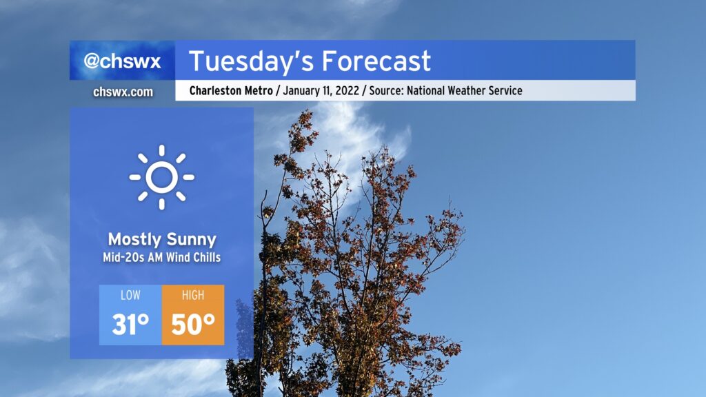
We’ve got another chilly Tuesday in store as lows drop below freezing away from the coast tonight. Expect temperatures around 30-31° to begin the day in the Charleston metro area, with upper 20s further inland. Winds will make it feel like the mid-20s, though, so be dressed with layers accordingly.
Despite full sunshine, high temperatures will only top out around 50° in the afternoon. This runs about 10° below normal for this point in January.
Otherwise, no other major weather hazards are expected. Enjoy your Tuesday.
We’ll see some showers and thunderstorms overnight as a cold front approaches the area. No severe weather is expected, but some gusty winds and brief heavy downpours are possible as the line gets through. Rain should clear the area before daybreak.
Once the front is through, temperatures will plummet and clouds will scour out. Expect high temperatures to only top out around the mid-50s with some afternoon sunshine. Then, we’ll have a pretty cold night overnight Monday into Tuesday morning, with lows getting into the upper 20s in the metro area away from the coast. Highs on Tuesday will only top out in the upper 40s despite full sunshine.
After another somewhat hard freeze Wednesday morning, temperatures will begin to moderate some as an upper disturbance approaches from the west and high pressure slips offshore. We might see a few showers Thursday morning as the disturbance swings through, but will close the work week with mostly sunny skies. Showers re-enter the realm of possibilities for the weekend as another front approaches the area. Temperatures will remain generally around if not a click or two below normal.