Jared Smith founded @chswx on Twitter in 2008 as an experiment in disseminating weather data through social media. In the ensuing decade-and-a-half, @chswx has provided live coverage of tropical cyclones, tornadoes, severe weather, and even a couple bouts of winter weather to the good people of Charleston, SC.
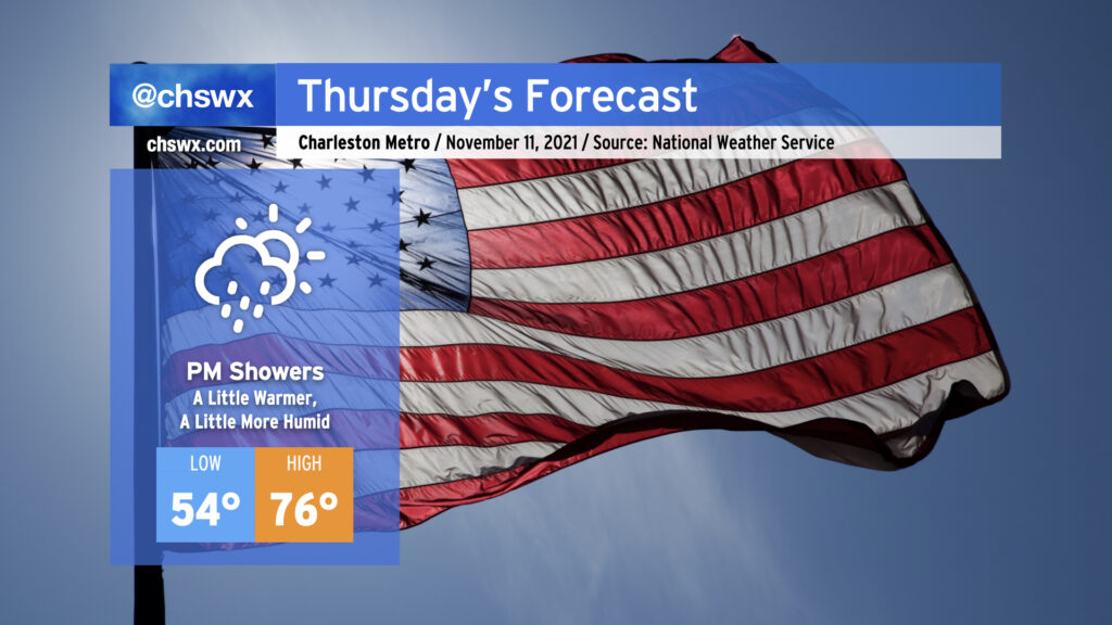
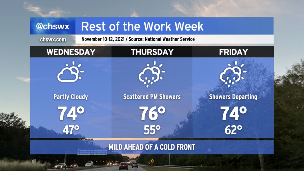
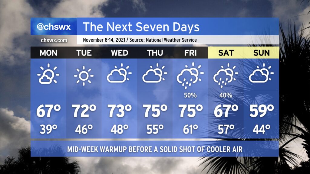
We’ll have our warmest and most humid day for another week or so on Thursday ahead of a cold front and sharp upper trough which should bring some showers into the area starting as early as the late afternoon through Friday morning. Temperatures for this Veterans Day will run a few degrees above normal thanks to southerly flow ahead of the front — expect mid-70s in the afternoon. Dewpoints in the 60s will certainly feel a little more humid than we’ve felt the past few days, too. Expect rainfall amounts to run generally on the light side, with a few spots possibly recording around a quarter-inch of rain on the high end.
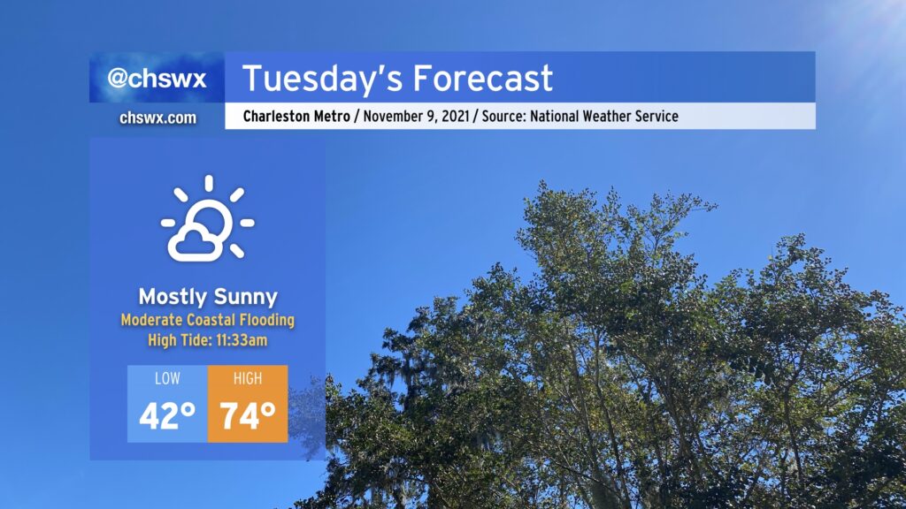
One other good thing about the southerly to southwesterly flow that’s developing is that it should help put an end to this week of coastal flooding. The tide in the harbor reached 7.17′ this morning, allowing for some shallow salt water flooding to occur. It’s expected that tomorrow’s tides will stay below the 7′ threshold for the first time since this stretch of coastal flooding began November 3rd. (And good riddance, too.)
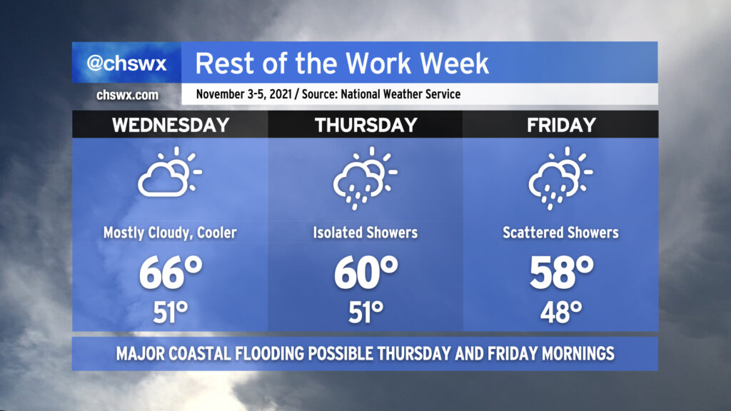
The rest of the work week will be on the mild side as high pressure slips offshore ahead of a cold front. Wednesday will start a little on the cloudy side, which will act to keep lows from falling too far below the mid-40s in most spots. The sun will come back in the afternoon and yield another pleasant day with highs in the mid-70s.
Thereafter, a cold front approaches the area Thursday into Friday, bringing some scattered showers to the area beginning Thursday afternoon. A thunderstorm or two can’t be ruled out, either, but severe weather is not expected. Temperatures start in the mid-50s and top out in the mid-70s on Thursday. Friday starts even warmer, perhaps in the low 60s, before showers depart and cooler, drier air begins working into the area. Even still, expect highs in the mid-70s on Friday.
Don’t let the sweaters slip too far away — another cooldown is in the cards for the weekend with a series of reinforcing cold fronts into next week.
There is a small risk for some minor coastal flooding early Wednesday afternoon, but otherwise, this event appears to be finally in the books. This was a brutal stretch: we’ve had some degree of coastal flooding each day since November 3, with four consecutive days of major flooding between November 5-8. Three top-15 tides were set, including Sunday morning’s high tide at 8.51’ which was good for tenth highest on record.
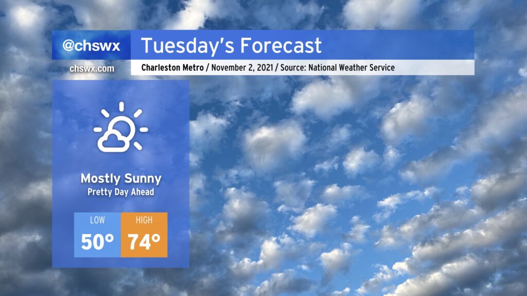
Tuesday is going to be an excellent weather day across the Lowcountry with mostly sunny skies and temperatures warming nicely into the mid-70s in the afternoon as high pressure remains in firm control at the surface. We won’t start quite as chilly as we did this morning — the low of 37° today was the coldest since April 4, when it was also 37° — but it’ll still feel crisp with low 40s away from the warmer coastline.
We still cannot shake the risk for coastal flooding on Tuesday. Moderate coastal flooding is once again forecast around the 11:33am high tide, which should close some roads in downtown Charleston near the lunch hour. While a fifth consecutive day of major flooding is not expected, it is still well within the possibility that salt water could impinge upon major roads downtown, including the 17-to-61 off-ramp, Lockwood Blvd., and the areas around the City Market among other places. Be ready once again to use alternate routes. Fingers crossed that this is it!
After a tumultuous weekend of coastal flooding, wind, record-low maximum temperatures, and rain, the week ahead offers a nice respite. We’ll start the week chilly, with lows in the 30s away from the immediate coast warming to the mid-60s for Monday. The 70s return for a few days thereafter, with mostly fair weather until a cold front approaches the area late Thursday into Friday, bringing rain chances back into the picture for Friday and perhaps parts of Saturday. Don’t let the sweaters get too far out of reach, though: by Sunday, we’ll be feeling quite a cooldown as highs struggle to reach 60° despite partly cloudy skies.
A coastal flooding threat continues with the Monday morning high tide, which could again approach moderate coastal flood thresholds (7.5’ mean lower low water). High tide is forecast to peak around 10:32am. What’s a few more road closures after this insane weekend of flooding, in which we reached 8’ tides three times, including setting the 10th and 11th highest water levels on record at Charleston Harbor? The good news is that the coastal flood threat winds down thereafter as astronomical influences wane and offshore winds continue.
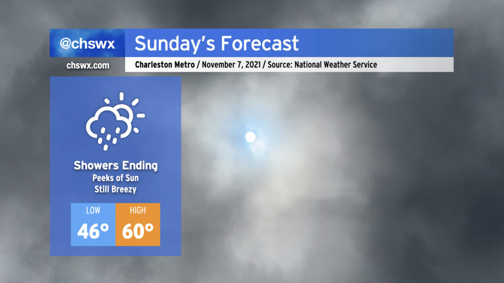
Our weather takes a positive turn Sunday as the coastal storm moves northeast and away from the area. We will see some showers hanging around in the morning, but these will depart as the morning goes on. Expect the sun to begin peeking through by afternoon before sunset at 5:24 PM. (Don’t forget to set your clocks back an hour tonight!)
Temperatures will thankfully respond to the sunshine as well, with highs around 60° in the afternoon. (The normal high for November 7, though, is 72°.)
Winds will remain breezy, with gusts to 30 MPH still a possibility as we remain within a very tight pressure gradient between high pressure to the west and low pressure to the east. Use extra caution on bridges and overpasses once again tomorrow.
There will be a risk for minor to moderate for tidal flooding Sunday morning. Water levels could approach about 7.5′ with the 9:34 AM high tide. Be ready for a few road closures, though certainly nothing to the extent that was seen this morning when the water level peaked at 8.44′, good for 11th highest on record at Charleston Harbor.
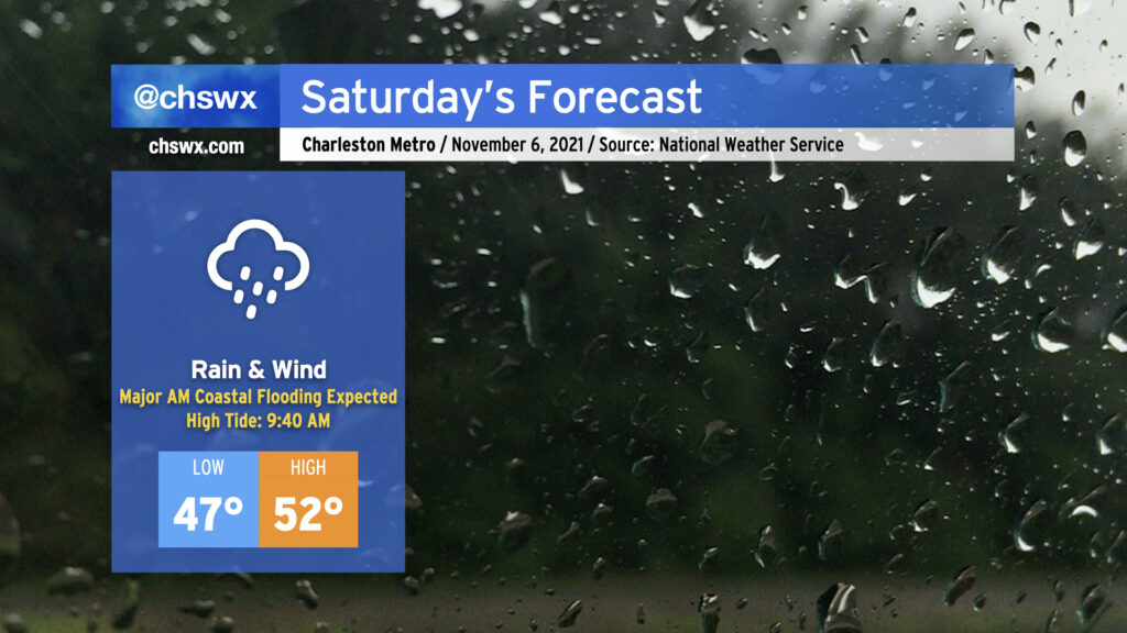
Saturday’s gonna be a meteorological mess, it appears. A coastal storm, which has been trending more westward in modeling, is expected to develop tonight and move parallel to the coast during the day Saturday. This is going to bring the potential for periods of heavy rain, gusty winds (with gusts 30-40 mph possible particularly near the coast), and a forecasted top-10 tide in Charleston Harbor during the morning hours.
High tide on Saturday morning is currently forecast to peak between 8.5-8.7′ in Charleston Harbor. This would be good enough for at least tenth on record at the harbor, and would be the highest tide since the water level reached 8.76′ on November 24, 2018. This will introduce significant salt water flooding across downtown Charleston, resulting in numerous road closures. It’s also possible that we will see road closures along Long Point Rd. in Mt. Pleasant and Harborview Rd. on James Island. The tide is forecast to peak at 9:40am, but with these events, there’s often a little lag, so it may peak later. Expect floodwater 2-3 hours either side of high tide.
Guidance continues to hit on the potential for rain to be in the area around this time of high tide, which could make the situation even more dicey. One other thing to keep in mind is that there will be a round of minor tidal flooding on Saturday evening, as well. Some simulated radar products bring some of the heaviest rain into the area Saturday afternoon, ahead of high tide. If it’s enough rain, we could be in for a long-duration flooding event. This will bear close watch throughout the day. The NWS forecast is generally for 2-3″ of rain across Charleston County, with somewhat lower amounts inland.
Finally, with the strong pressure gradient between developing low pressure to our east and high pressure to our northwest, winds will turn quite gusty at times. Gusts to 40 MPH appear possible on bridges and overpasses as well as the beaches. (It’s this strong northeast wind which will help drive water levels higher.)
Combine all this with highs in the low 50s, and well…you’ve got a perfect excuse to stay in on Saturday.
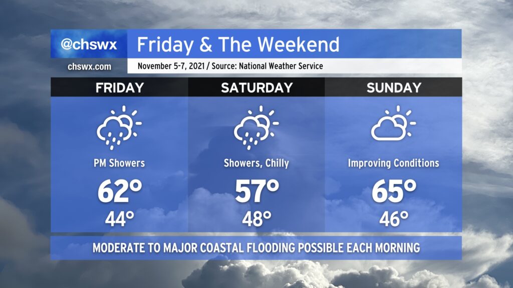
Much cooler than normal temperatures will persist for Friday into the weekend as a high pressure wedge remains in place, keeping north to northeasterly flow over the area through Sunday. As a coastal storm organizes offshore — how far offshore remains quite an important forecast question — we’ll see an uptick in rain chances beginning Friday evening into Saturday. Where the storm sets up will largely influence just how much rain we get, an important piece considering the specter of an 8’+ high tide on Saturday morning. If heavy rain coincides with that tide, what looks to already be a significant coastal flooding event gets that much worse.
The coastal storm will lift away from the area heading into Saturday night, and we should see some more sunshine on Sunday. Moderate to major flooding remains a threat with the Sunday morning high tide, though, and will need to be watched carefully. We’ll stay on the chilly side, too, with highs only topping out in the mid-60s — more January than November.
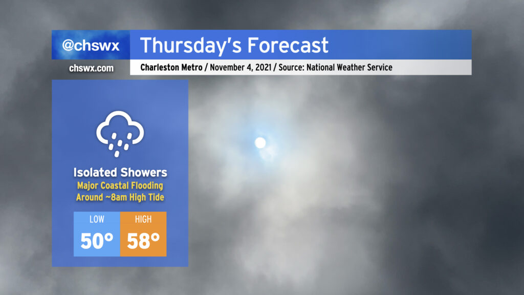
Thursday is going to have more of a mid-January feel to it as high pressure continues to wedge southward across the area, with breezy northeast winds, cloud cover, and maybe a shower or two helping to keep temperatures down into the 50s in the afternoon for the first time since early April. Suffice to say, it’s a sweater alert day across the Lowcountry!
The main weather-driven issue for Thursday, though, will be the risk for major coastal flooding around the morning high tide, which is forecast to peak between 8.0-8.2′ around 8am. If this water level verifies, it’ll close quite a few roads and make navigation around downtown Charleston unusually difficult. Salt water flooding could begin 2-3 hours ahead of the time of high tide, too, so be ready for some sporadic road closures even if your commute is on the early side. A Coastal Flood Watch is in effect for tomorrow morning between 5-11am. If the water level does look like it will approach 8′, the National Weather Service will upgrade this to a Coastal Flood Warning.
Another round of coastal flooding is expected with the evening high tide, which is predicted around 8:12pm and should peak around 7.3-7.4′. Minor to moderate flooding will be possible with this tide as well, though it won’t be nearly as widespread or severe as what is expected out of the morning high tide.
If there’s one bit of good news in all this, it’s that today’s tides underperformed guidance. This certainly is not a bellwether for lower-than-forecast water levels tomorrow, but it’s something to watch as forecasts for this event get calibrated over the next few days.
After a couple days of 70s and sunshine, cold air damming will begin to ooze into the area on Wednesday, kicking up cloud cover and keeping temperatures down into the mid-60s. It’s the first really good sweater weather day of the year, and the last fully rain-free day until Sunday. Thereafter, a storm system will affect our area from Thursday into the weekend. The wedge will remain intact through the rest of the work week, keeping gusty northeasterly winds — which could get as strong as gale force over the waters on Friday — in the area and cloud cover in place. Overrunning moisture will help contribute to a few showers on Thursday with more coverage Friday depending on where low pressure develops offshore. This, in turn, will help keep temperatures suppressed at or below 60° for Thursday and Friday. The last time we had a high below 60° was April 2nd, when the high topped out at a balmy 53°.
We’ve got one more really nice day on Tuesday before temperatures begin to fall back off into sweater weather territory. (Not that there’s anything wrong with that.) Expect highs to top out in the mid-70s after starting around 50° in the morning with mostly sunny skies throughout. We’ll begin to cool off after Tuesday as high pressure wedges southward into the area; highs don’t get out of the 60s on Wednesday and Thursday, and might not even crack 60° on Friday.