Jared Smith founded @chswx on Twitter in 2008 as an experiment in disseminating weather data through social media. In the ensuing decade-and-a-half, @chswx has provided live coverage of tropical cyclones, tornadoes, severe weather, and even a couple bouts of winter weather to the good people of Charleston, SC.
Sunday will finish with a little more warmth than we’ve had the last couple days as high pressure slips offshore and a front stalls out nearby. Clouds will be on the increase throughout the day, but rainfall is expected to hold off until overnight. Highs will top out in the mid-80s; with dewpoints in the 60s, this will feel a little warmer and more humid than we felt on Saturday.
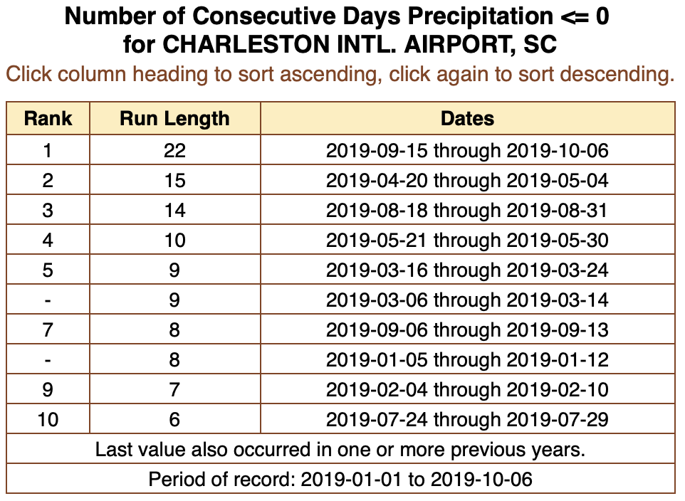
For the first time since September 14, the airport has recorded measurable rainfall. (Traces of rain were recorded September 15, September 30, October 5, and October 6.) As of this writing, a whole one-hundredth of an inch has been recorded at the airport today. (Hey, it’s something.)
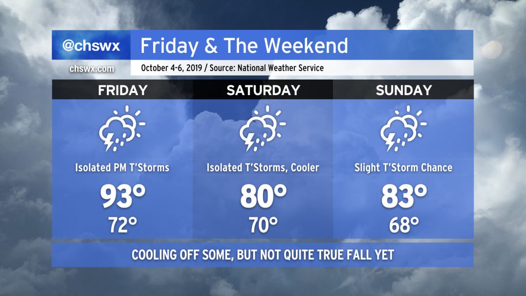
We’ve just got one more sweltering Augtober day left before a backdoor cold front swings through the area, cooling us off for the weekend. This will come with a little bit of much-needed rain, too, but don’t expect a washout. After that, another frontal system will usher in a little bit more Fall weather.
Our abnormally warm and dry September will roll into the first few days of October as strong high pressure aloft remains anchored over the southeast U.S.
Changes are coming, though, and I suspect many of you will be OK with them.
Fall fans, the news isn’t great: Above-normal temperatures will continue for the foreseeable future as a strong ridge of high pressure remains firmly entrenched over the area. A weakening front nearby will help kick off a few showers and maybe a thunderstorm or two across the area. This would be good — it’s been twelve days since measurable rain at the airport — but not everyone is going to get relief. Rain-free conditions move back into the area for the weekend while temperatures in the upper 80s remain more in line with mid-August norms than late September.
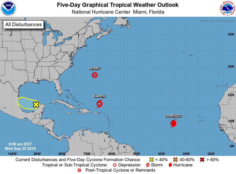
The tropical Atlantic basin remains fairly active: While Jerry is no longer a tropical cyclone, it continues to spread strong winds and heavy rain across Bermuda. Lorenzo, well out in the Atlantic, has strengthened to a hurricane and is no threat to any land at this time.
By the time some of you read this, the autumnal equinox will likely have passed (3:09 am), ushering in astronomical Fall. (It’s been meteorological fall since September 1.) Don’t tell that to Ma Nature, though. High pressure aloft is re-establishing itself, ushering us back into what is effectively a very summer-like pattern for the upcoming week.
We have a really nice weekend of weather coming up as high pressure remains firmly in control across the area. Cool starts will give way to comfortably warm afternoons with highs in the mid-80s and low humidity. Rain chances are nil, and we should see plentiful sunshine throughout the weekend.
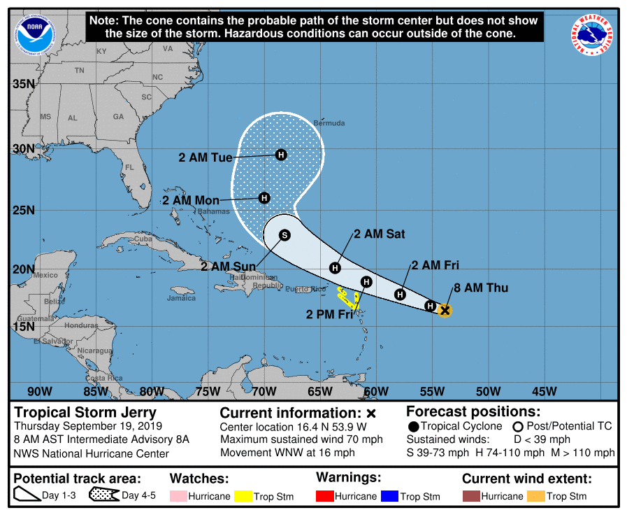
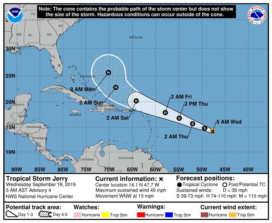
So let’s start with the good stuff: Model agreement has continued to improve regarding Tropical Storm Jerry’s future path, and that path is toward recurvature way from the US East Coast this weekend. (Bermuda, which just took a pretty good whooping from Humberto, will want to watch Jerry with wary eyes.) But, for Charleston, Jerry increasingly looks like a storm about nothing. It is forecast to become a hurricane later today, but will encounter hostile upper-air conditions that will limit its further development, according to the Hurricane Center. This should preclude the stronger solutions and a more southerly track as seen in a few of the global guidance members that we discussed yesterday.
Tropical Depression Ten strengthened overnight, having reached Tropical Storm status and the threshold to receive a name. The name most of us thought this system would get was Imelda, but a tropical depression formed quickly near the Gulf Coast yesterday and was named within an hour’s time. Imelda is already inland, so we are now watching Tropical Storm Jerry as it churns in the Atlantic, 960 miles east of the Leeward Islands (and a lot farther than that from Charleston!)