Jared Smith founded @chswx on Twitter in 2008 as an experiment in disseminating weather data through social media. In the ensuing decade-and-a-half, @chswx has provided live coverage of tropical cyclones, tornadoes, severe weather, and even a couple bouts of winter weather to the good people of Charleston, SC.
Since the Good Friday severe weather event, weather has been largely quiet in the Charleston metro area. Even a front that swung through this past Friday wasn’t able to eke out any rain across the Lowcountry. As a ridge of upper-level high pressure continues to be in control, we have more warm, dry days ahead.
The warmest stretch of 2019 (thus far, anyway) continues today as high pressure slips a little further offshore. Highs in the upper 80s will be commonplace away from the immediate coast. If mid-week beach days are your thing, today definitely qualifies.
High pressure remains in control of the forecast through Thursday, yielding several quiet weather days. (That sound you hear is the collective sigh of lots of Charleston-area meteorologists who spent much of Friday doing battle with spin-up tornadoes.)
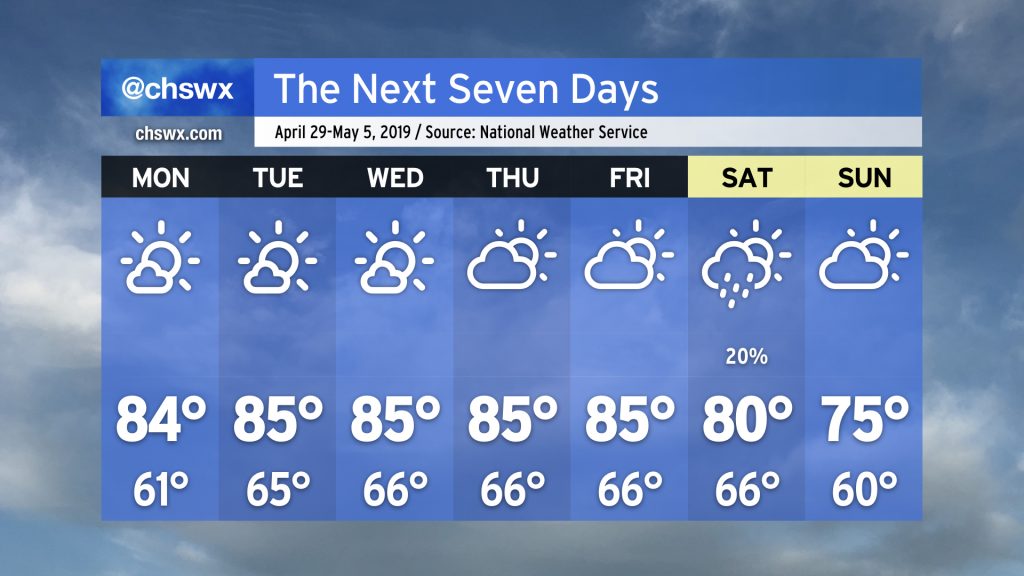
We’ll maintain seasonable conditions through Tuesday as high pressure gradually slips offshore. Southerly flow around the back side of the high turns on the heat pump for Wednesday and Thursday, with highs expected to top out in the upper 80s for the first time this year. A cold front will then approach on Friday, bringing a chance for showers and thunderstorms to the area. Some chance of rain lingers through the weekend, but it’s nothing to toss your plans over.
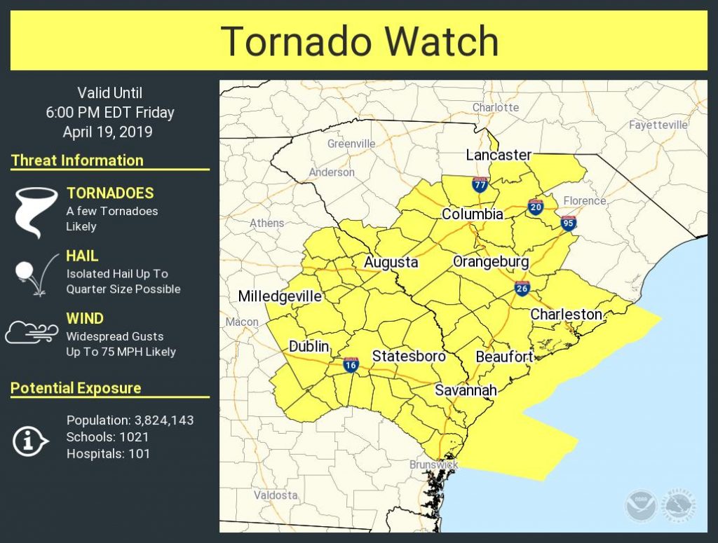
Charleston is under the gun for potentially strong to severe thunderstorms today as a strong cold front, aided by vigorous winds aloft, approaches the area.
Expect a squall line with damaging wind gusts, isolated embedded tornadoes, and hail to come through the area later this afternoon into early evening. Timing for this event will be a little later in the afternoon; suspect anytime after 2PM will be tricky if thunderstorms do not erupt ahead of the line. This will almost certainly have impacts on the evening commute, particularly for those of you trying to get a head start on Easter travel.
GOES-East mid-level water vapor illustrating the vigorous trough of low pressure which is kicking off severe weather in Texas and Oklahoma this evening.
Friday is an important day to watch in the weather department as there is good model agreement that a storm system will be affecting the area during the day, driving a squall line into the area by afternoon. Gusty winds, hail, coastal flooding, heavy rain, and perhaps even a tornado will be possible. Let’s take a look at some of the issues we may encounter.
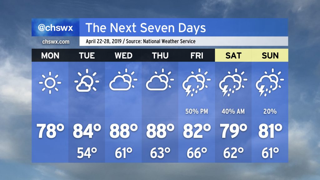
Spring has come into full swing here in the Lowcountry. After what was a fortunate severe weather non-event on Sunday, we had a much cooler and less humid Monday with highs topping out around 74° under plenty of sunshine. We get a repeat of that today as high pressure maintains control over our weather today through Thursday. Our next storm threat comes Friday, and may bring some strong winds to the area. Let’s dive in…
We have a potentially busy weather day in store today as a strong cold front — which has been responsible for several strong, damaging tornadoes in Texas and Mississippi — cuts its way across the Southeast toward our area tonight.
Today’s pattern is somewhat reminiscent of August (thankfully not from a temperature perspective!). High pressure offshore will pump moisture into the area; I can’t rule out some scattered showers and storms this morning as some moisture convergence works its way northward.
This afternoon, the focus for showers and thunderstorms will shift inland with the seabreeze. No severe weather is expected but we could wring out a few tenths of an inch of rain in spots — not that we’re complaining, as we still need the rain.
Temperatures will top out in the upper 70s in the metro area; should see some lower 80s a little further inland before the seabreeze gets there.
More on another busy Charleston weekend (High Water Fest!) on the blog later today.
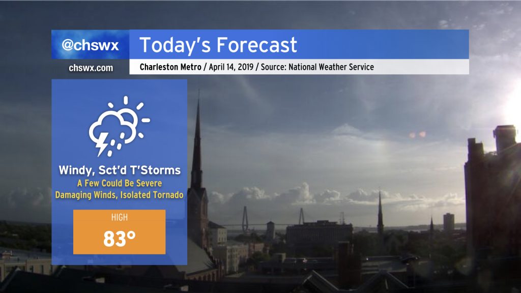
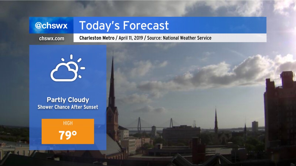
Today’s forecast calls for an overall nice, warm mid-April day with temperatures in the upper 70s to around 80 this afternoon away from the locally cooler coastline, which will see highs suppressed into the low-to-mid-70s with a decent seabreeze.
Don’t be surprised if we’re talking about showers later tonight as surface high pressure begins to pull away, allowing a coastal trough to drift ashore. Latest guidance this morning suggests a shower chance as early as 8PM, but it’s looking a little more likely starting around 10-11 PM. Rainfall amounts don’t look particularly heinous, but if you have late night plans, you’ll want to keep rain gear within reach just in case.