Jared Smith founded @chswx on Twitter in 2008 as an experiment in disseminating weather data through social media. In the ensuing decade-and-a-half, @chswx has provided live coverage of tropical cyclones, tornadoes, severe weather, and even a couple bouts of winter weather to the good people of Charleston, SC.
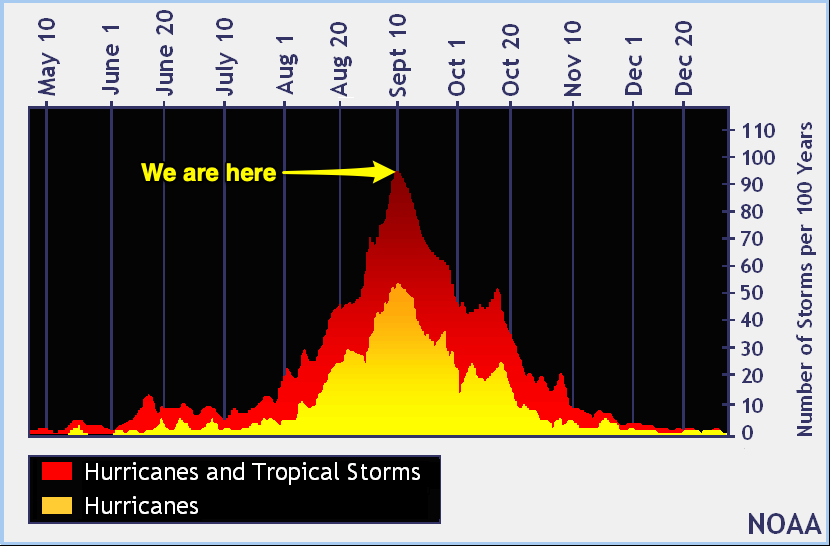
Today is September 10, which marks the climatological peak of hurricane season in the Atlantic basin. Fresh off our brush with Dorian, let’s take a look at where we are and where we might be headed for the rest of the season, which runs through November 30.
The week ahead will continue to feature a late-summer heat wave, especially as we kick off the new work week. Temperatures in the 90s will feel closer to the 100s with humidity with just a slight chance of an afternoon shower or storm to cool things off. Thunderstorm chances kick up as we head into the weekend as a tropical disturbance (more on that in a sec) is set to move through Florida, enhancing moisture in our neck of the woods.
An abnormally strong ridge of high pressure is going to build in for the weekend, keeping rain chances relatively low and temperatures rather high for early September. In fact, the record high of 95° for Saturday is forecast to be at least tied. By Sunday, more humidity works its way in and heat indices may exceed 105°. Aside from an isolated afternoon thunderstorm, relief from the heat looks unlikely. Keep this in mind if you or someone you know remains without power — they’re going to want some air conditioning this weekend!
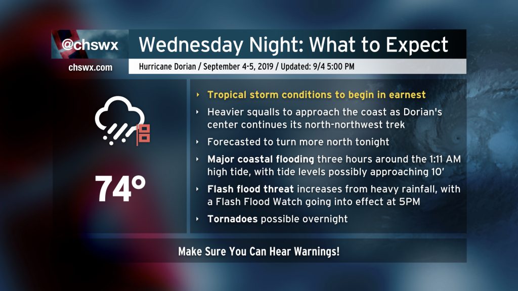
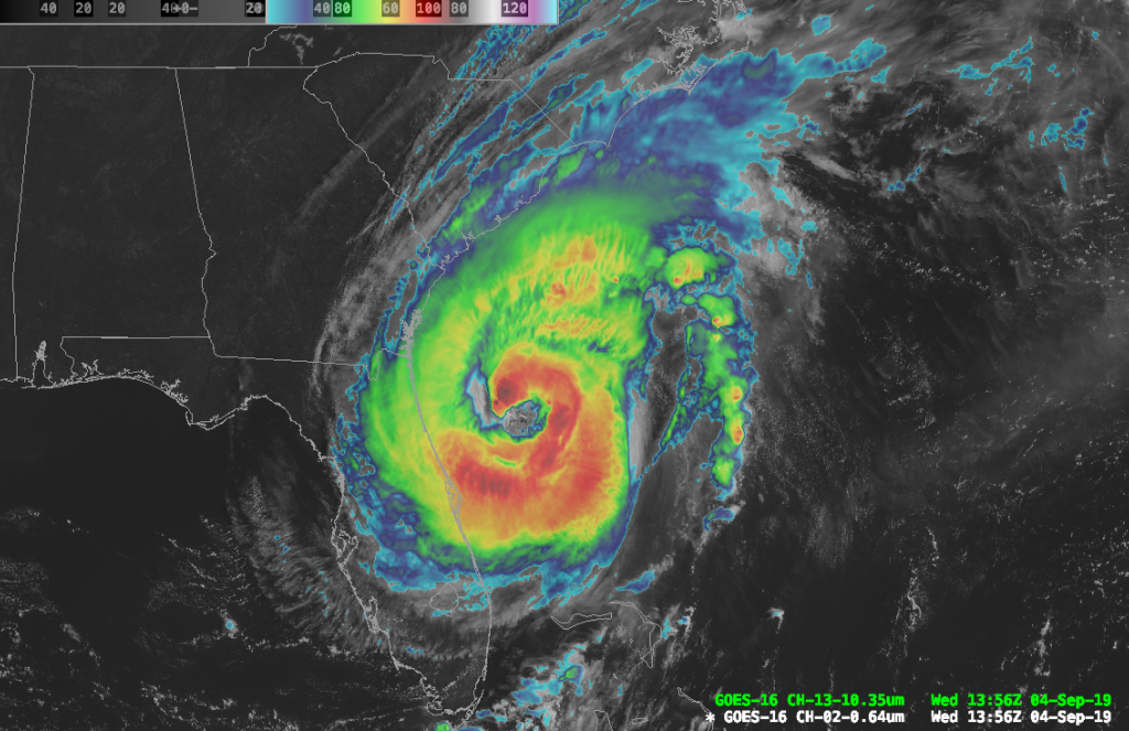
Dorian is about to ramp up across the Charleston metro area as the storm’s more central rainfall begins coming ashore. Tropical storm-force winds are already being felt at Folly Beach, and will spread further inland with time. Your window to safely evacuate has closed. Time to shelter in place and ride this thing out.
Prepare for the potential for flash flooding, power outages, and perhaps a tornado. Make sure you can hear severe weather alerts and that they can wake you!
Hurricane Dorian is making its move on Charleston. Going forward, I’ll be live-blogging updates as needed from the National Hurricane Center and sharing storm reports.
Dorian Day 1 has arrived in the Lowcountry. Clouds from the storm’s outflow have been blanketing the area for about 12-15 hours now, and the first rain bands are approaching shore. Here’s what to expect over the next couple days.
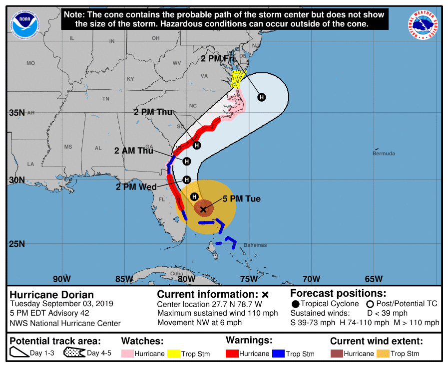
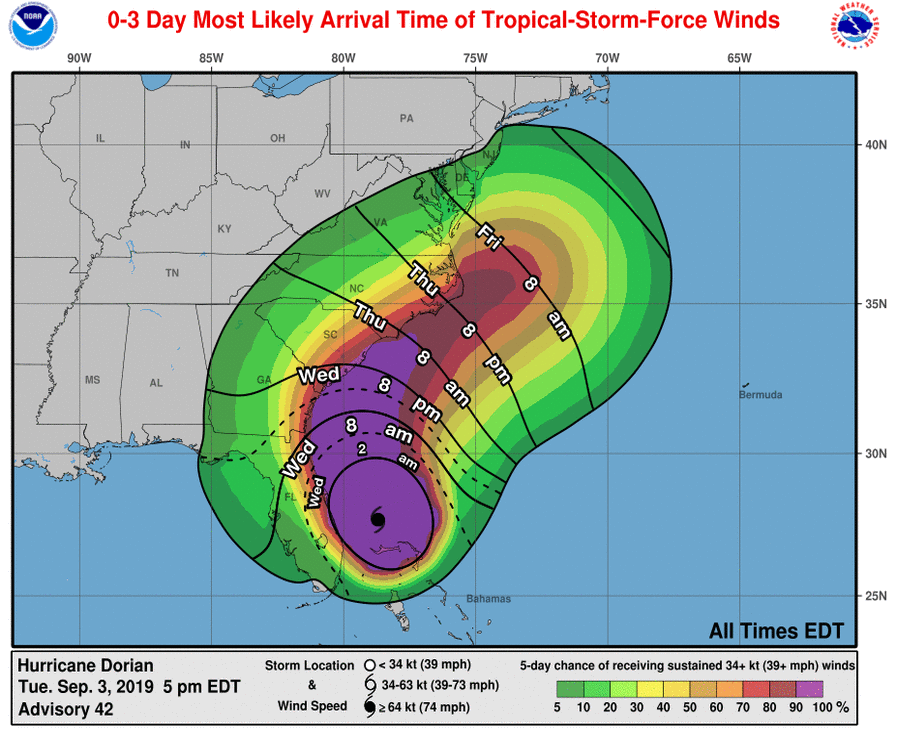
Advisory 42 for Hurricane Dorian continues to indicate a high-end Category 2 storm with max winds of 110 MPH. It has picked up some forward speed and is now moving NW at 6 MPH. A Hurricane Warning and Storm Surge Warning continue for Charleston, with Tropical Storm Warnings inland.
The most notable change in this update is that NHC has shifted the track and cone of uncertainty westward, making its closest pass to Charleston Thursday afternoon. This shift westward is going to increase the potential for hurricane-force winds along the coast (and perhaps slightly inland), add to the storm surge threat, and increase the potential for heavy, flooding rainfall. Be preparing for high-end category 2 hurricane conditions!
Preparations should wrap up this evening. Rain bands will likely begin overnight with tropical storm-force gusts. More sustained tropical storm-force winds are possible as early as Wednesday at 8am, and should overspread the area by Wednesday evening.
This post will be updated with new impact graphics.
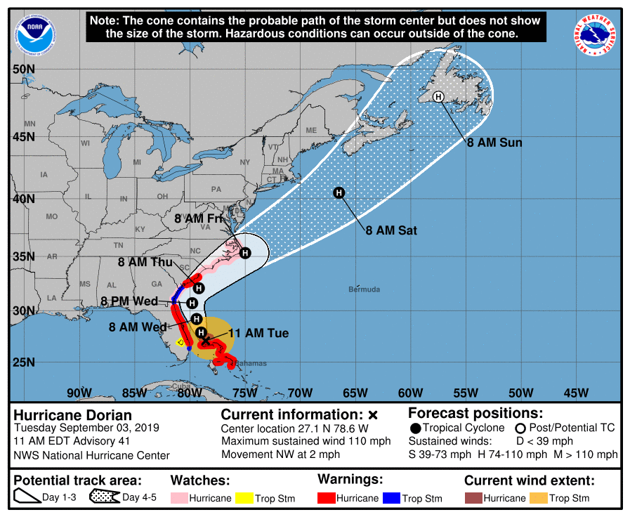
Advisory 41 on Dorian is in, and it is now a category 2 storm on the Saffir-Simpson wind scale with maximum sustained winds of 110 MPH. The storm is now moving northwest at 2 MPH, and is expected to make a turn more to the north sometime tomorrow, paralleling the coastline.
Recapping active alerts:
A Hurricane Warning is in effect for Charleston and Berkeley Counties.
A Storm Surge Warning is in effect for Charleston and tidal Berkeley counties.
A Tropical Storm Warning is in effect for Dorchester County.
A Flash Flood Watch will be in effect from Wednesday morning to Friday morning.
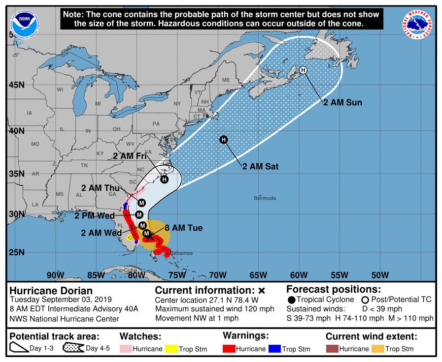
At 8am, Dorian resumed forward motion for the first time in 18 hours — moving NW at 1. It remains a strong Category 3 hurricane with max winds of 120 MPH.
Now that the storm has started moving again, we should be able to finish forecast fine-tuning later today.
What to do today
Finish storm preparation today. We are still on track for adverse weather to move in Wednesday, with the bulk of tropical storm and possibly hurricane conditions starting Wednesday evening through much of Thursday. Bring in loose items, secure personal property, and give the disaster kit one last look. Give extra attention to things like batteries for flashlights; with the bulk of the worst conditions currently timed overnight Wednesday into Thursday, overnight power outages are likely.
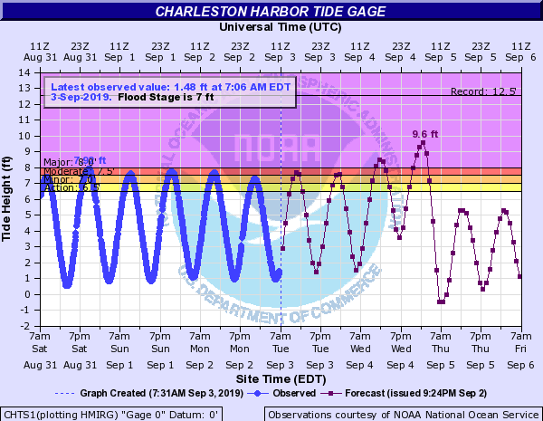
Watch for flooding around the noon high tide. Moderate flooding may close roads downtown. Be ready to use alternate routes.
If evacuating, leave today. Weather heads downhill tomorrow and you just won’t want to drive through it. If you’re not leaving, just get ready to stay put for a couple days as Dorian brushes us.
Next update
The next track and intensity forecast update arrives at 11am. Confidence is increasing in the forecast track and subsequent impacts, and I expect a warning of some type to be hoisted with that advisory.
Hurricane Dorian continues to sit stationary just north of Grand Bahama Island, lashing the island with its eyewall (as it has for much of the day). As the storm has remained stationary, it has weakened somewhat, but remains a dangerous Category 4 storm with maximum sustained winds of 130 MPH as of the 11 PM advisory.