Jared Smith founded @chswx on Twitter in 2008 as an experiment in disseminating weather data through social media. In the ensuing decade-and-a-half, @chswx has provided live coverage of tropical cyclones, tornadoes, severe weather, and even a couple bouts of winter weather to the good people of Charleston, SC.
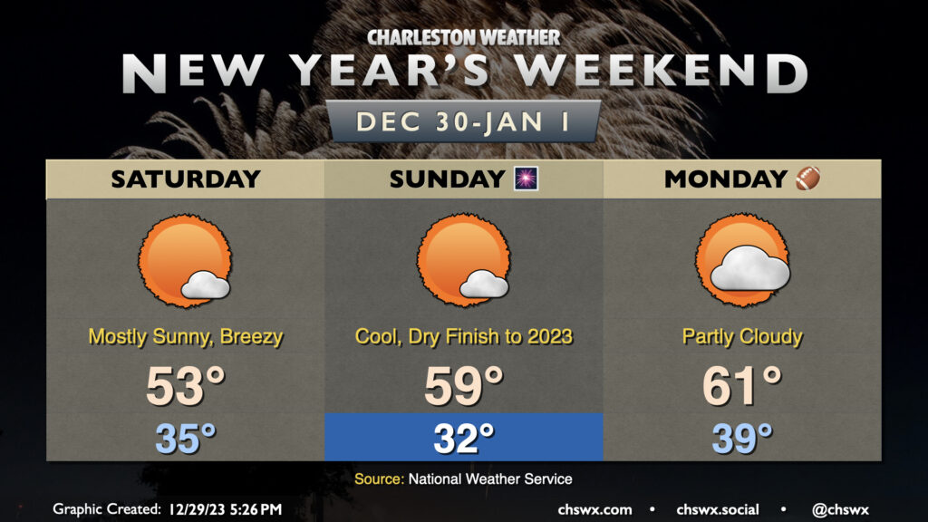
We’ll depart 2023 and enter 2024 with a minimum of meteorological fanfare as high pressure remains in control through Monday. Temperatures on Saturday will start in the mid-30s, but elevated winds will make it feel closer to the upper 20s. Highs will only top out in the low 50s as gusts reach 25-30 MPH once again during the prime heating of the day. The chill is in spite of nearly full sunshine, though much like Friday, a fair-weather cumulus field should take shape.
Clear skies and diminishing winds will improve radiational cooling conditions overnight Saturday into Sunday, and so we should start the day around the freezing mark away from the coast. Another mostly sunny day lies ahead, and a warming trend will start to kick in as the core of the cold air moves out. Expect temperatures to head close to 59-60° in the afternoon, right in striking distance of December 31 norms. There are no weather concerns for New Year’s festivities on Sunday night except for the need for a jacket — it’ll be getting into the low 40s in many spots as we ring in 2024.
New Year’s Day will start a little warmer, with lows in the upper 30s to around 40° warming to the low 60s in the afternoon. There will be a little more cloud cover ahead of a cold front that’ll swing through overnight Monday into Tuesday with a slight chance of a few showers. The next substantial rain chance appears to be next Thursday with a stronger front moving by, followed by high pressure leading into the first weekend of 2024.
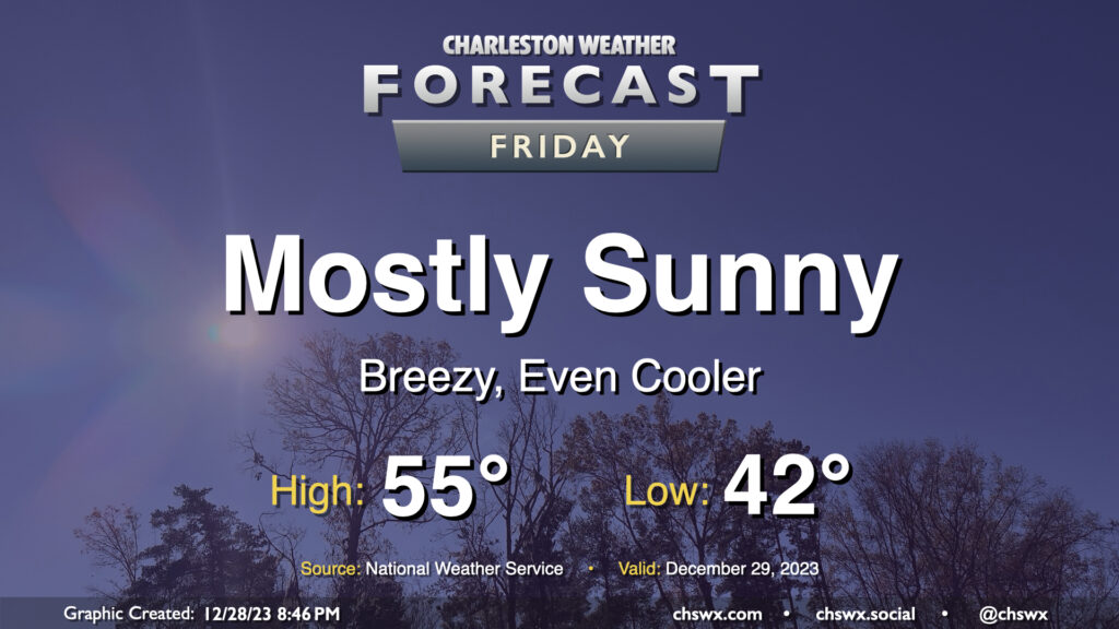
A cold front coming through overnight will send temperatures even cooler for Friday. We start the day in the low 40s, but cold air will be blowing in throughout the day. This will keep temperatures suppressed to about the mid-50s in the afternoon despite mostly sunny skies. It’ll be a breezy day, too; winds will generally run 10-15 MPH with gusts to 25 MPH as daytime heating helps push mixing heights to about 5,000 feet. Cloud cover will generally be sparse with a fairly dry atmosphere in place, with maybe a few fair weather cumulus showing up from time to time.
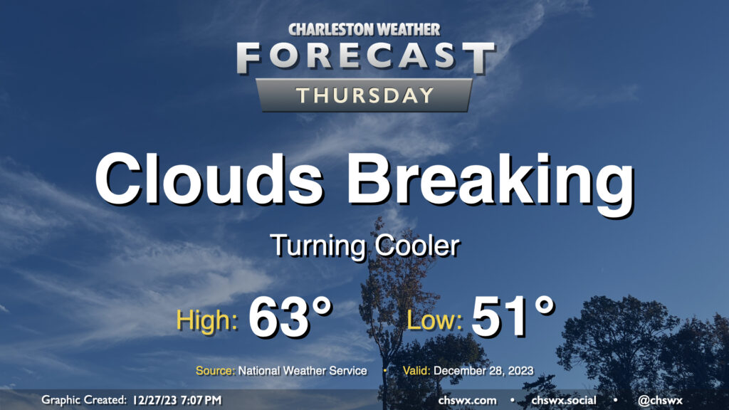
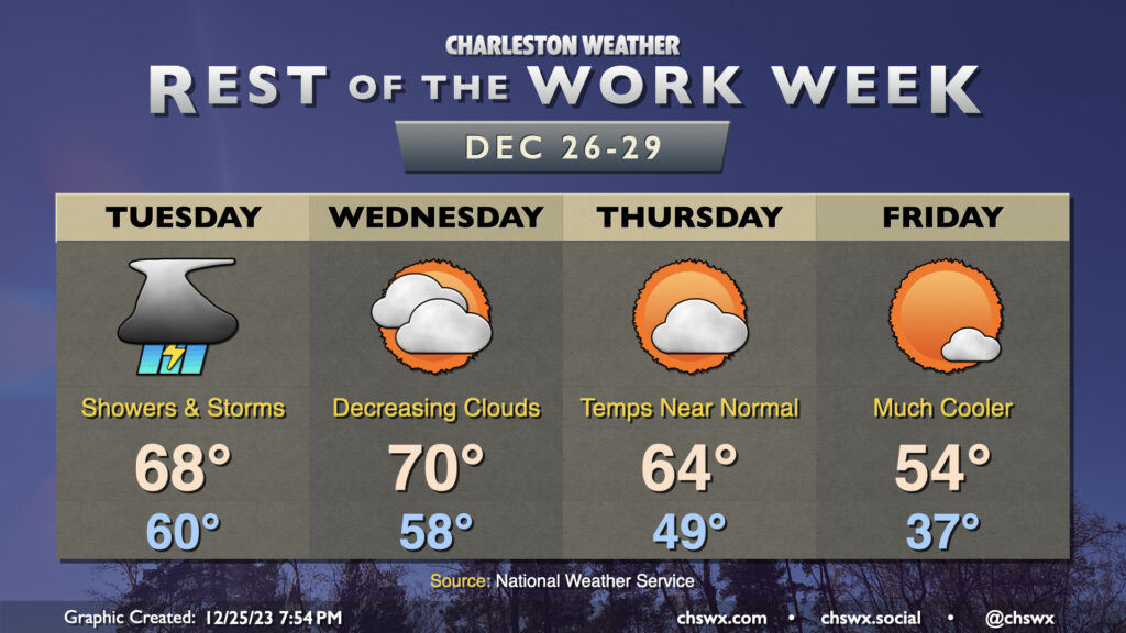
Thursday will be a much cooler day than Wednesday was across the Lowcountry, where most stations made it into the 70s at some point during the day, as an initial round of cooler and drier air infiltrates the area ahead of a reinforcing front which will really chill us out for Friday into the weekend. Dewpoints fall into the mid-40s throughout the night, allowing temperatures to drop generally into the low 50s to start Thursday. We’ll top out in the low-to-mid-60s in the afternoon — still a touch above normal — as clouds gradually start to break up along with the cold front’s passage.
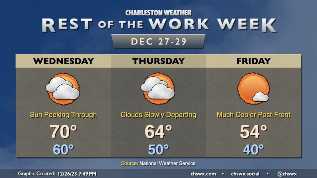
After low pressure departs the area early Wednesday morning, that will be it for rain for 2023 as we’ll embark on a drying and (slow) clearing trend heading into New Year’s Weekend. Wednesday will probably be the last day we touch 70° this year as cooler and drier air starts to work into the area later in the day. We’ll see dewpoints fall first and then temperatures will follow as we get into the evening hours. This’ll yield a Thursday that starts 10° cooler (but still well above late December normals) and warms to about the mid-60s in the afternoon. We should see a bit more in the way of sunshine on Thursday, but clouds will remain a bit pesky until a stronger (but dry) front gets through late Thursday. We’ll wake up another 10° cooler on Friday, with lows in the upper 30s to around 40° yielding to highs just in the mid-50s as cooler air works into the area throughout the day. At least the sun will be out!
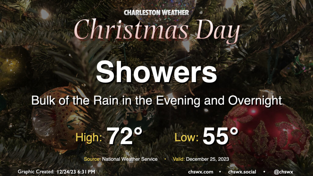
Wet weather continues overnight Christmas into Tuesday, as showers and thunderstorms with occasional patches of heavy rain continue to move through the area. Flooding will be a concern particularly in the morning as high tide around 7:15am, which should exceed flood stage in Charleston Harbor, could coincide with periods of heavy rain. This combination may produce more widespread flooding than a typical tidal event, making roads impassable and causing them to close. Be ready to route around flooded roads and for delays — perhaps significant — if downtown is in your travel plans Tuesday morning.
Showers and thunderstorms look to continue for a fair bit of Tuesday. We should start to see rain begin to scatter out as we head into the evening, though lingering showers will be possible overnight. Temperatures will be rather mild — the low of 60° is pretty close to the normal high for December 26. We’ll warm to the upper 60s, limited mostly by rain in the area.
Cloud cover will break up some on Wednesday as some drier air moves in. It’ll be another warm day, with lows in the upper 50s yielding to highs around 70° in the afternoon. Some cooler air begins to work into the area on Thursday as cloud cover ticks down, with highs running about 5° or so cooler than Wednesday. Then, a cold front later Thursday will usher in even cooler air, knocking Friday’s temperatures well below normal. Expect lows in the mid-30s to yield to highs only in the mid-50s in the afternoon despite mostly sunny skies.
Unsettled weather arrives for Christmas as a complex and sprawling storm system begins to affect the area. We should see a few scattered showers in the morning through early afternoon, but expect shower coverage and intensity to tick up as we get further into the afternoon and evening hours. Temperatures on Christmas will run much warmer than climatology, though not into record territory. Expect lows in the mid-50s to yield to the low 70s in the afternoon before rain starts to kick in.
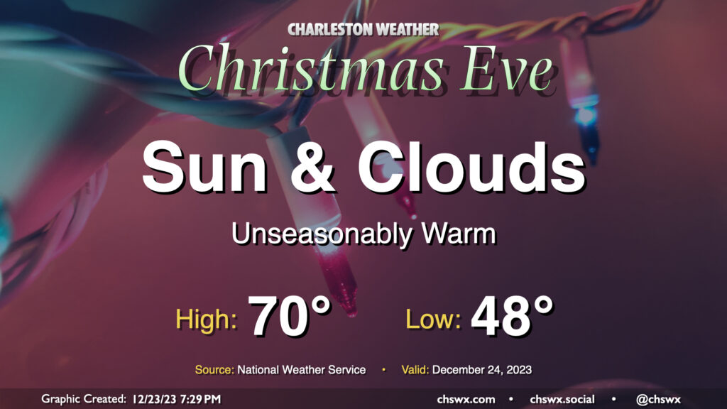
Water levels in Charleston Harbor look to reach flood stage (7′ MLLW) with the 6:30am high tide. This will put some salt water on some of the more vulnerable roads in Downtown Charleston, but no rain is expected to coincide, limiting the breadth of any flooding threat.
We have one more quiet day of weather ahead for Christmas Eve before a storm system starts to affect the area on Christmas Day. It’ll be an unseasonably warm Christmas Eve, that’s for sure: We start the day in the upper 40s to around 50° before warming to around 70° in the afternoon. The normal high for December 24 is 61°, while the low is typically closer to 41°. No records will be threatened, though: the record high of 80° set in 2015 remains safe.
The sky will generally feature a mix of sun and clouds. There is a small possibility a few showers could try to sneak onshore, so if you’re out at the coast or very nearby, don’t be surprised to get a light shower or two as a coastal trough develops. However, much of us will remain rain-free throughout the day and overnight, so there are no significant concerns for a certain sleigh aviator as he makes his rounds in our neck of the woods.
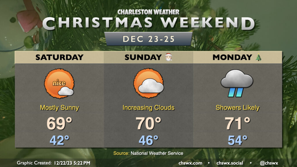
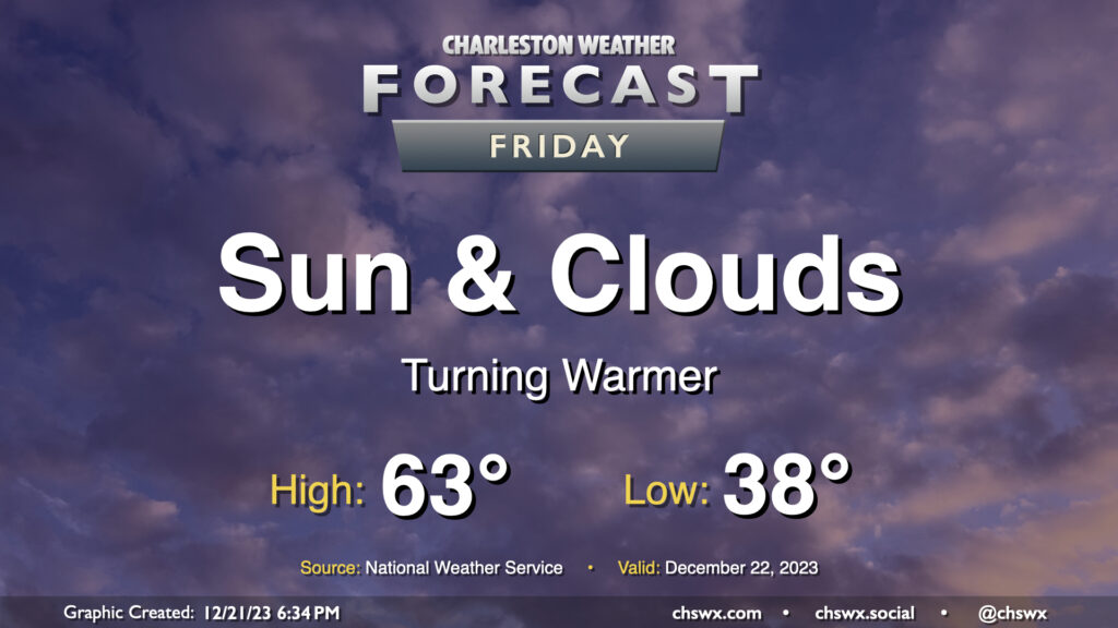
A warming trend continues for Friday as we head into Christmas weekend. We’ll get off to a warmer start — though it’ll still be in the mid-to-upper 30s — than we did on Thursday, which dipped back into the upper 20s. Temperatures Friday afternoon should once again head to the low-to-mid-60s with a mix of sunshine and high cloud cover as high pressure continues to be the main weather feature at the surface and aloft.
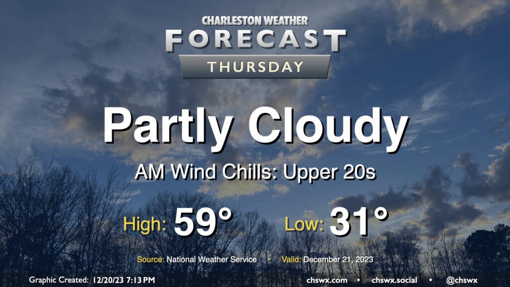
We have another chilly day ahead Thursday as we’ll once again start the day below freezing, though perhaps not to the degree we saw across the area Wednesday morning, when Charleston International Airport dropped to 27°, the coldest temperature this year and the coldest it’s been since December 28, 2022.
A warming trend will commence Thursday as highs head to the upper 50s under partly cloudy to mostly sunny skies as ridging moves overhead. While you’ll still want a jacket, it might not need to be as heavy!