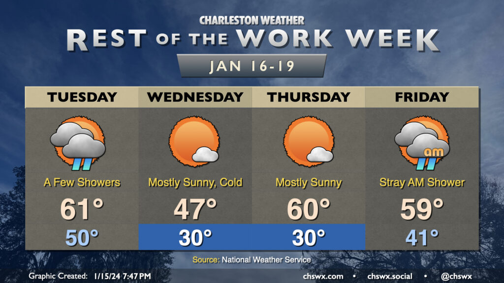
Temperatures will be somewhat fickle this week as a series of fronts move through the area. Tuesday will trend on the warm side, with lows around 50° to start the day heading into the low 60s in the afternoon as the first front moves by. A few showers will be possible along and ahead of the front, primarily midday through early evening. They won’t have much moisture to wring out, so expect the showers to be on the light side. From there, temperatures will plummet overnight.
We will most definitely know that a front has come through Wednesday morning. We’ll wake up to subfreezing temperatures across much of the area away from the immediate coast; breezy northwesterly winds will make it feel closer to the low 20s. The ongoing cold advection will prevent temperatures from reaching too far into the upper 40s in the afternoon despite mostly sunny skies.
Thursday gets off to a similarly chilly start (though with less wind, at least) as lows once again head toward around 30° (and likely colder further inland and in rural areas). However, the coldest air will be departing during the day, and temperatures head to around normal in the afternoon, generally running around 60°. The respite from the very cold air continues Friday. We’ll wake up in the low 40s and top out in the upper 50s to around 60° with a few morning showers possible as another front moves by, which brings the coldest air thus far this season into the area for the weekend.
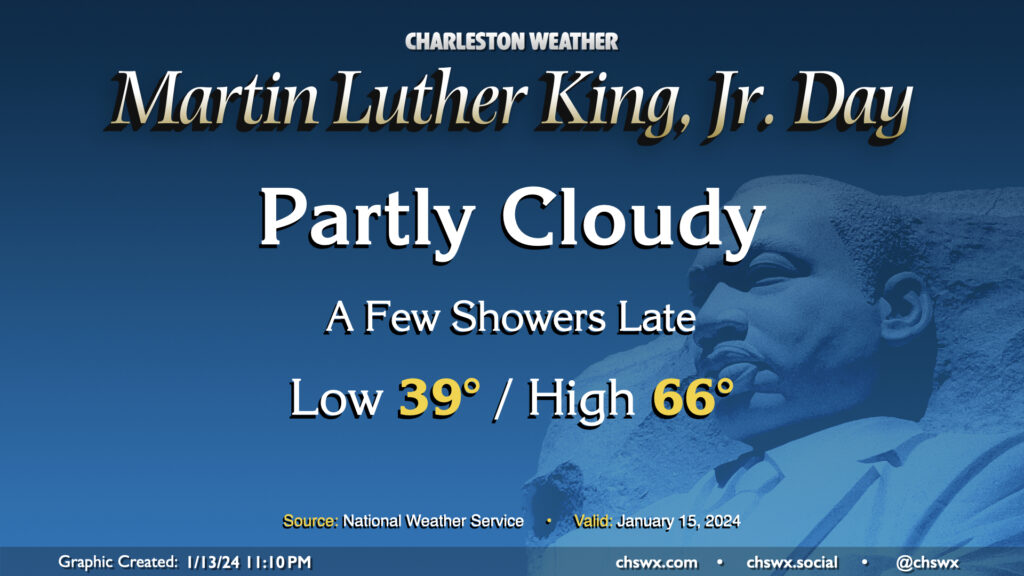
Martin Luther King, Jr. Day will be a generally quiet day of weather, with just a few showers potentially developing late. We start the day in the upper 30s, warming to the mid-60s (and maybe beyond) in the afternoon despite increasing cloud cover. Dry conditions should persist through sunset; thereafter, a few showers could move into the area as a front approaches. Overall, though, outdoor activities look to be generally okay and rain-free.
Slight shower chances persist as we head into Tuesday. Another front will then send some very cold air our direction. We’re going to feel it big-time on Wednesday as we wake up to air temperatures around freezing, but the westerly wind around 10 MPH will make it feel much colder (think low 20s). Strong cold advection will keep temperatures limited to the upper 40s in the afternoon. After a freezing start Thursday morning, temperatures recover to near 60° in the afternoon under partly cloudy skies. Another front swings through Friday, and that’ll usher in another round of even colder air over the weekend. Pipe-busting lows in the 20s could be quite common, particularly Sunday morning, with highs topping out just in the low 40s. Stay tuned to forecast updates this week as more data comes in.
Quieter weather returns to the area for the weekend, and not a moment too soon. We start Saturday in the mid-40s, but a breezy westerly wind will keep temperatures suppressed to the mid-50s despite partly cloudy skies as cool air blows in behind a cold front. Cloud cover decreases overnight and winds calm down, allowing for decent radiational cooling conditions for Sunday morning, when temperatures look to fall back to the mid-30s (and maybe near freezing in more rural areas). It’ll be a brilliantly sunny day, and temperatures will respond nicely, heading into the low 60s in the afternoon. Quiet weather should prevail for much of Martin Luther King, Jr. Day, too, with only a few showers possible after sunset; the better risk for rain arrives Tuesday.
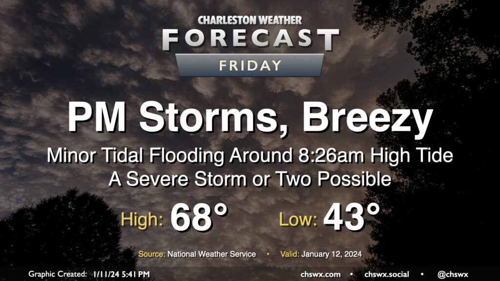
Another storm system will impact the area on Friday with gusty winds and some showers and storms in the afternoon and evening hours, with a few pockets of severe weather possible, but certainly not the widespread threat that we saw on Tuesday.
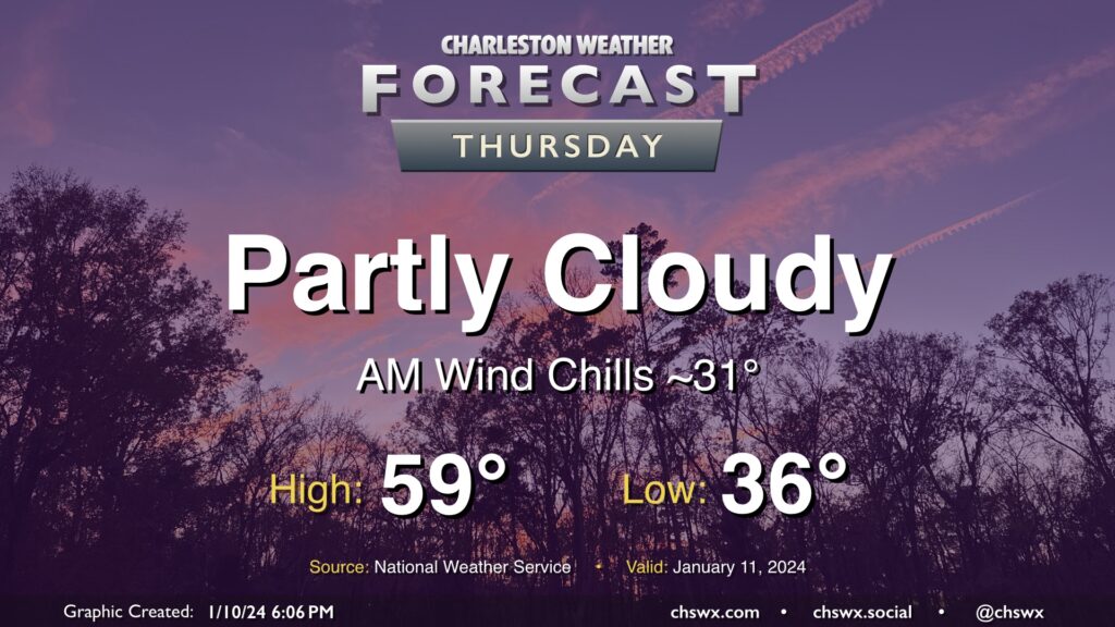
High pressure will be in control for one more day on Thursday. We’ll start the day a little cooler than we did on Wednesday, and certainly much less windy, too. However, a light breeze will still make lows in the mid-30s feel closer to freezing. Temperatures will head to the upper 50s in the afternoon under a mix of sun and cloud cover.