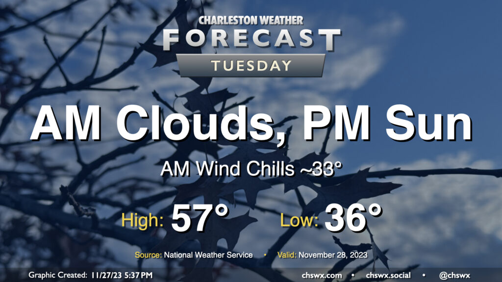
Tuesday will begin a string of a few chilly mornings across the metro area. Temperatures will start in the mid-30s; breezy northwest winds will make it feel closer to freezing, so bundle up accordingly. (There should be too much wind and too little moisture for frost formation, BTW.) Cloud cover will hang around for the morning before scouring out in the afternoon. Even so, highs will struggle to the mid-to-upper 50s as northerly winds continue to blow cold air into the region.
There will be a chance for a little salt water to creep up out of some drains around Lockwood as well as out of Gadsden Creek with Tuesday morning’s high tide, though it should peak just shy of coastal flood criteria. Still, you don’t want to drive through salt water if you can help it. High tide on Tuesday morning is expected to peak around 8:17am.
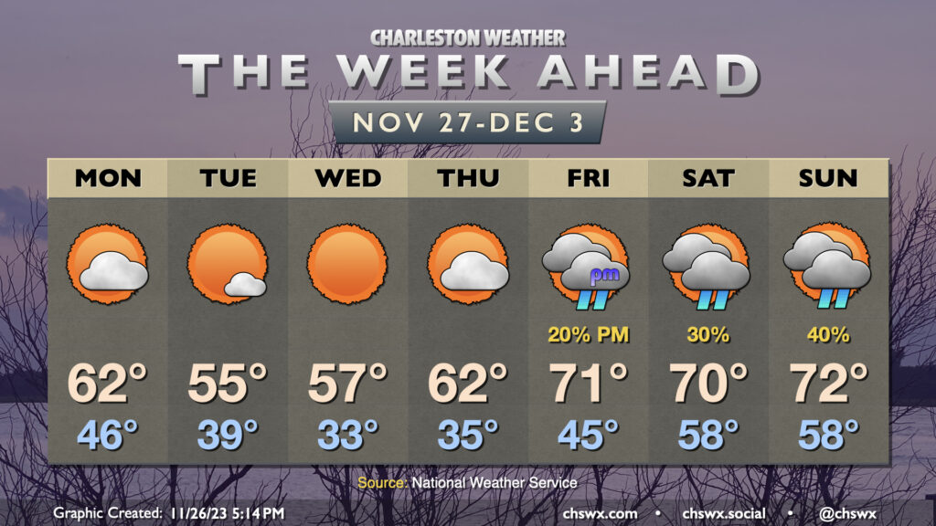
After a very chilly and raw Sunday in which the high temperature didn’t (as of this writing, anyway) reach 50°, temperatures make a brief rebound for Monday in the wake of a front as high pressure builds in. Diminishing cloud cover and northwesterly winds will help temperatures rebound to the low 60s on Monday, which will feel positively wonderful. Temperatures will then drop into the upper 30s for Tuesday morning as the cooler high pressure begins to settle in over the area. Temperatures will only reach the mid-50s on Tuesday despite ample sunshine. Radiational cooling conditions improve tremendously as winds go light and skies go clear Tuesday night into Wednesday morning, and this will allow temperatures to get down to freezing for the first time this season in many spots in the metro, particularly inland. Highs will head to the mid-50s once again with full sunshine.
From there, high pressure begins to move away, turning nature’s heat pump back on as winds go more southerly. We’ll get off to another frosty start Thursday morning before warming to the low 60s in the afternoon. Friday will be even warmer, with lows in the mid-40s (closer to normal for this point in the year) and highs in the low 70s in the afternoon. We’ll keep this warmer weather going into the weekend, with lows well above normal for Saturday and Sunday, albeit with some shower chances as mid-level disturbances swing through from time to time.
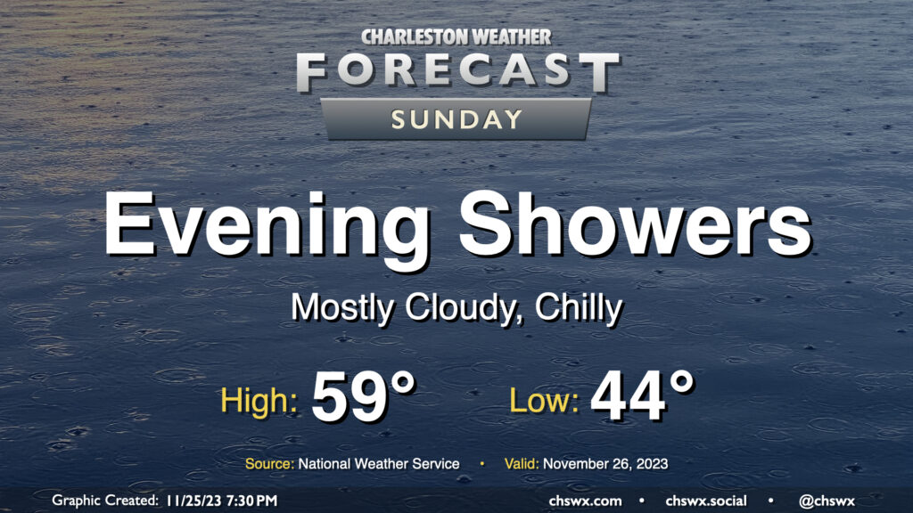
Sunday will feature more in the way of cloud cover as another disturbance affects the area. High pressure wedging southward will help keep things on the cool side as northeasterly winds continue to blow into the area. We start the day in the mid-40s and may not reach 60° in the afternoon thanks to the cloud cover. We should stay rain-free for the morning through early afternoon; from there, showers may begin to develop and move across the area. The best chance for showers will be in the evening as low pressure to the south makes the closest approach. Rainfall should generally be on the light side, but a few pockets of heavier rain certainly can’t be ruled out. Rain should clear the area by Monday morning as high pressure builds back into the area.
The other weather concern for Sunday will arrive early in the morning in the form of coastal flooding. Favorable northeasterly winds and astronomical effects the upcoming full moon will drive water levels into minor to possibly moderate flood stage around the 6:44am high tide Sunday. Salt water may close some roads as water levels approach 7.4-7.6′. If you have early-morning travel plans around the edges of the downtown peninsula, especially on the west side, prepare to reroute around flooded and closed roads.
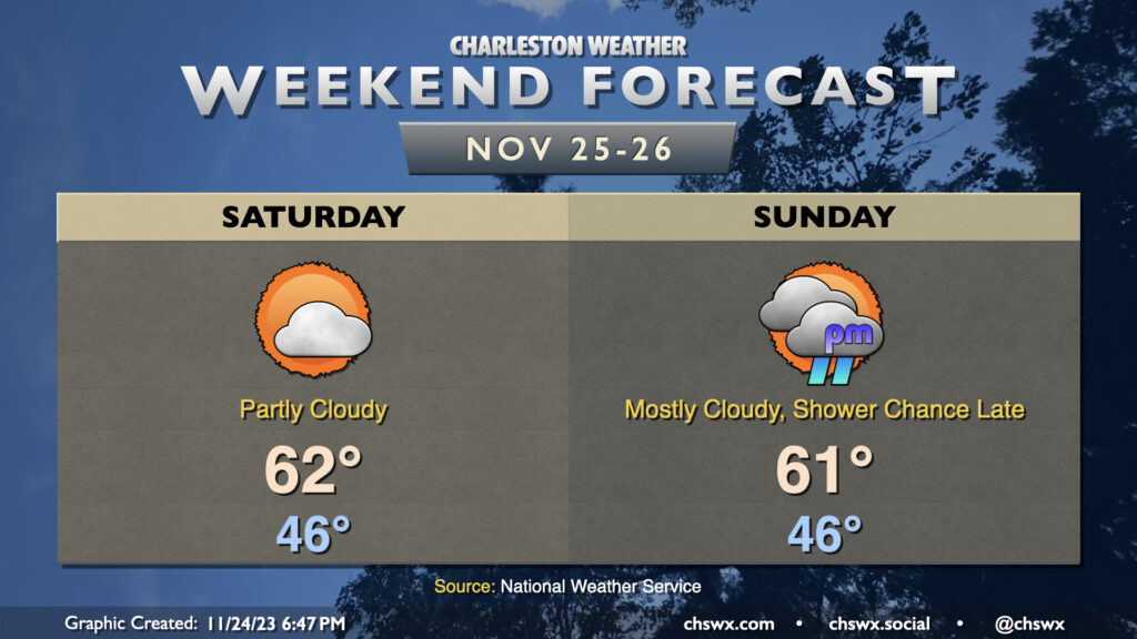
We’ll stay chilly over the weekend as high pressure wedges south into the area, keeping north and northeast winds in place throughout. Temperatures Saturday generally start in the mid-40s before warming to just the low 60s in the afternoon under partly cloudy skies, with clouds increasing as we get later in the day as another disturbance starts to draw closer. Increased cloud cover with the wedge hanging on tight will keep temperatures from getting too far above 60° in the afternoon on Sunday. We should get the daylight hours in rain-free, with showers on the increase as the aforementioned disturbance and associated surface low pass by overnight into early Monday.
The main weather concern will be the risk for coastal flooding early each morning this weekend thanks to the upcoming full moon and northeasterly winds, which are very favorable for piling up water in our neck of the woods. The water level forecast has increased for Charleston Harbor Saturday morning, and we now could look at 7.3-7.5′ with high tide around 6am, capable of closing some roads. Expect a repeat around Sunday morning’s 6:46am high tide as northeasterly winds persist, with water levels likely high enough to produce moderate coastal flooding (7.5-7.7′). Stay tuned for possible Coastal Flood Advisories from the National Weather Service.