After a fairly glorious day of weather Saturday, Sunday will make a 180° right back into more unsettled territory as high pressure moves offshore ahead of a cold front. A wave of low pressure will develop back in Georgia, helping to drag a warm front across the area in the morning. We’ll see an uptick in shower and thunderstorm activity possibly as soon as mid-morning, but the most likely time for rain will be in the afternoon hours through about sunset. Heavy rain will be possible, with the potential for rainfall in the 2-3″ range for some locations. Isolated flooding will be possible as a result. Additionally, the aforementioned surface low pressure looks to track inland of the area, and could enhance some low-level shear. If instability can develop — and that is a big if — a strong to severe storm or two will be possible, and there may even be a couple rotating cells. We’ll keep an eye on this, but the risk for severe storms generally remains low especially given the rain-cooled air. We start the day in the upper 60s, but highs only top out in the low 80s given the risk for widespread rain in the afternoon.
After this passes, it looks like we get off to a solid start to the work week (weather-wise, anyway), with mid-80s highs, comfortable low 60s dewpoints, and ample sunshine.
Well, if you’re going to do outside stuff this weekend, Saturday’s probably the day to do it. It’s going to be a gorgeous day — low humidity, plenty of sunshine, and comfortably warm temperatures in the mid-80s after starting out in the upper 50s to low 60s across the metro.
High pressure will slip offshore late Saturday, and dewpoints will climb back into the 70s for Sunday ahead of a cold front. Expect showers and thunderstorms to become somewhat numerous Sunday afternoon into the evening as the front approaches the area. We could see some enhanced rainfall, too, courtesy of a wave of low pressure moving along the front. Temperatures should stay in the low 80s with the expected showers and thunderstorms. Generally, expect .5-1″ of rain across the area, with locally heavier amounts. Severe weather is not expected.
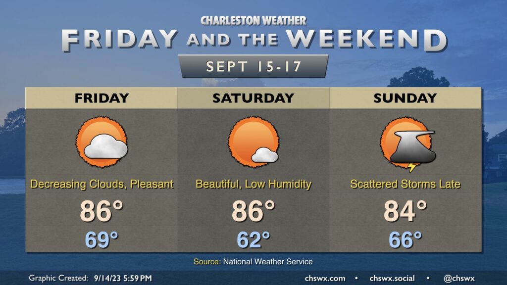
We get a break in the humidity Friday and Saturday as cooler and drier high pressure builds in from the northwest. Temperatures get off to a nice start on Friday, and persistent northeasterly winds will keep highs capped in the mid-80s as cloud cover decreases. Dewpoints, meanwhile, will plummet into the mid-50s, and this will allow relative humidity values to drop below 40%, making for rather comfortable warmth.
Saturday is probably the best day of the set to get outside, as we start the day in the low 60s before heading back to the mid-80s in the afternoon under mostly sunny skies. Dewpoints will again mix out into the mid-50s during the day, and we’ll have another round of sub-40% humidity.
High pressure slips offshore overnight Saturday, and by Sunday dewpoints will be rebounding back into the mid-to-upper 60s. Another front will be approaching the area during the day, and this will be the impetus for showers and thunderstorms as we get later into Sunday and Sunday evening. Highs top out in the mid-80s. Overall, expect temperatures to remain at or a little below normal as we head into next week.
A cold front will slip offshore early Thursday morning, but we won’t quite be feeling it just yet as some showers and thunderstorms will still be possible as moisture lingers across the area during the day Thursday. Highs top out once again in the upper 80s before showers and a few storms fire. Instability isn’t great and severe weather is not expected, though some heavy rain will yet be possible at times. The best chance to see a shower or storm looks to be in the afternoon and early evening hours.