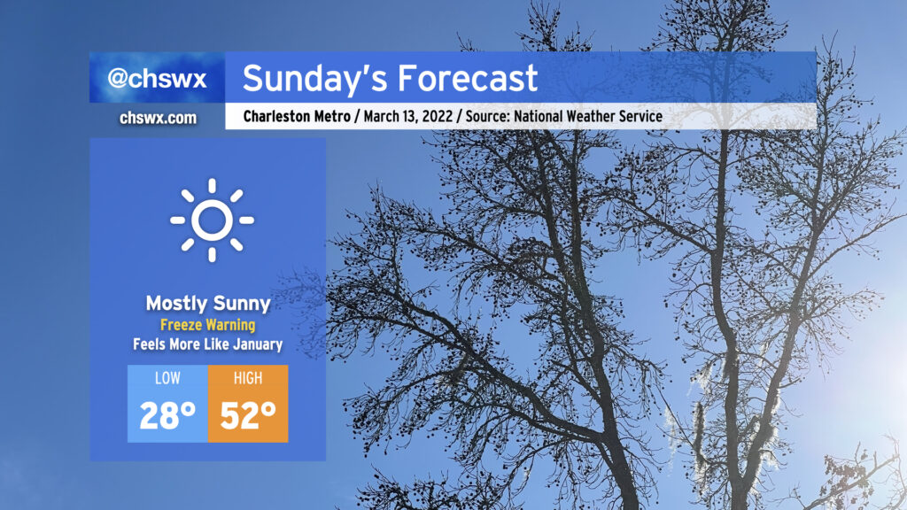
After today’s rather impressive cold frontal passage, an Arctic airmass settles into the area tonight into Sunday. A Freeze Warning is in effect through Sunday morning as lows head into the 20s across much of the metro area. Regardless of where you are, I’d take precautions with your plants tonight with freezing temperatures possible all the way to the coast.
Sunday won’t warm too terribly much. Highs will only top out in the low 50s despite full sunshine as the abnormally cold and dry airmass dominates our weather. It’ll be exceptionally dry, too, with relative humidity values dropping below 25% in the afternoon. Jackets and lip balm will be important on Sunday!
The good news is that this is March, and this will be relatively short-lived — we’ll be back in the 70s by Tuesday after one more light freeze possibly Sunday night into Monday morning.
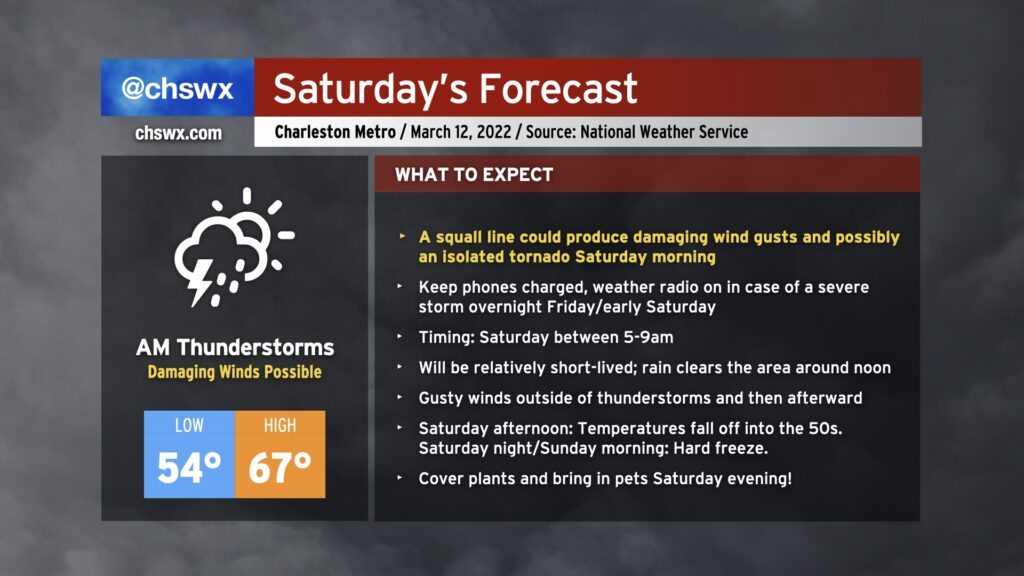
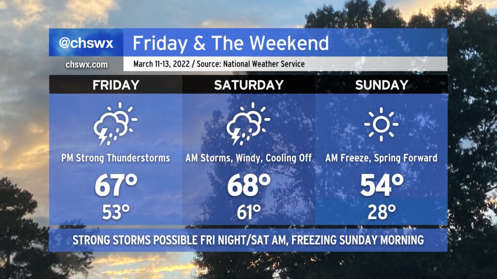
Saturday could be a bit of a wild day of weather across the Lowcountry. We’ll start with a strong cold front bringing a risk for strong to severe thunderstorms in the morning, and we’ll finish with Arctic air rushing into the area, leading to a hard freeze for many of us Sunday morning.
This weekend’s weather encapsulates the power of March in a nutshell: Cold air damming, followed by a severe weather threat, followed by an Arctic blast.
We’ll start Friday within the cold wedge that’s kept it cloudy and chilly across the area today. During the day, a warm front should lift north of the area, scouring out the wedge and putting us back in the warm sector of an approaching storm system. Showers and thunderstorms will be on the uptick as the front approaches, and a few of those could turn strong to severe especially as we get into Saturday morning. Guidance is pretty consistent in depicting a squall line-like feature moving through the area to start Saturday, promoting a damaging wind threat. A tornado or two could be possible inland as well, with that risk decreasing as you get closer to the coast and significantly cooler shelf waters.
After the front gets through Saturday morning, conditions will turn quite windy by afternoon as Arctic high pressure builds in from the northwest. The high temperature will be attained in the morning as we’ll cool off fairly substantially post-frontal passage, with temperatures just in the mid-50s in the afternoon.
Saturday night into Sunday morning, clocks will spring forward and temperatures will fall way back into the 20s in much of the metro area, with freezing temperatures possible to the coast. I’d advise everyone with tender vegetation to be ready for a freeze regardless of where you are; cover or bring in those sensitive plants and do not forget about your pets, either!
The chill will be short-lived heading into the new work week; we’ll be back in the 70s by Tuesday (along with another storm system).
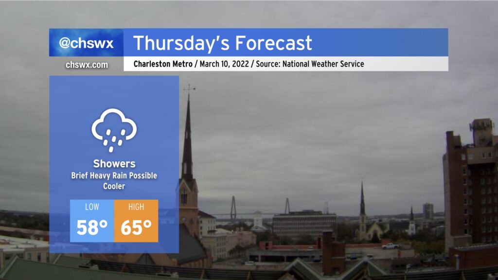
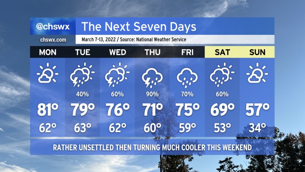
More needed rain will steadily fill in overnight as a cold front gets through the area and promptly stalls out nearby. We’ll see showers continue for much of Thursday before they taper off as the front gets shoved a little further offshore. Temperatures will certainly run much cooler — lows in the upper 50s will give way to highs only in the mid-60s in the afternoon.
A warm front lifts north of us tonight, putting us squarely in the warm sector of a storm system that will approach the area tomorrow before stalling out nearby Thursday. While we reside in that warm sector tomorrow, good turning of winds with height and decent instability will promote a risk for thunderstorms, a few of which could become severe. The main severe weather risk will be from damaging wind gusts, but if a supercell or two can get going, that will come along with an elevated risk for hail or even a tornado. Suffice to say, you’ll want to stay close to reliable and redundant sources of severe weather information tomorrow afternoon into the evening. NOAA Weather Radio is a great way to get alerts, and if it is enabled to do so, your phone can automatically alert you to tornado warnings, no app required.
Due to the risk of severe weather, the statewide tornado drill originally scheduled for Wednesday morning as part of South Carolina Severe Weather and Flood Safety Week has been moved to Friday at 9am.
We will have a lull in the severe weather threat on Thursday, but expect plenty of showers and even a few thunderstorms to linger as the front remains stalled out close by. Another risk of severe weather is possible late Friday into early Saturday morning as another front approaches the area. This front will bring cold high pressure for later Saturday into Sunday, with the risk of a freeze on Sunday morning.
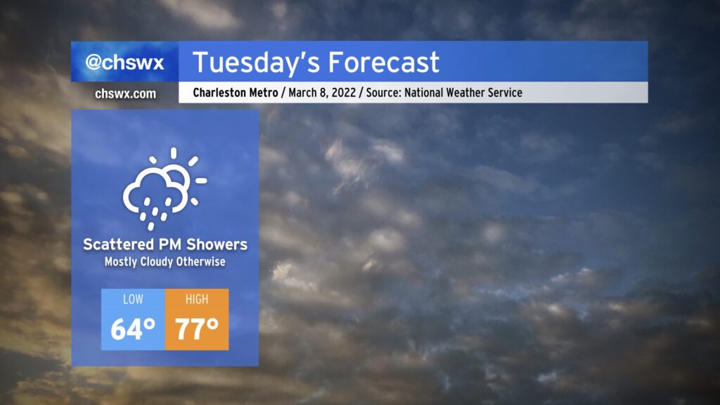
Cloud cover and eventually shower chances return to the forecast tomorrow as a cold front edges closer to the area. The clouds will help keep the morning rather balmy — 64° is the forecast low, just a few degrees below the normal high for this point in the year. Highs will head into the mid-to-upper 70s, but won’t quite be able to reach 80° given the increase in cloud cover and the development of scattered showers in the afternoon. It won’t rain all afternoon, but be ready for that potential especially during the evening commute.
Rain chances continue to ramp up this week as the cold front stalls across the area, with more widespread rain expected to develop Wednesday into Thursday. Rain stays in the forecast through Saturday until a cold front shifts offshore, shutting off precipitation and ushering in some very cold air — perhaps reaching freezing — for Sunday away from the immediate coast.
A solid pollen rinse is in the offing this week as a cold front is forecast to stall over the area, keeping showers and thunderstorms in the area for much of the upcoming work week.
First, though, we have one more day of great weather teed up for Monday. It’ll be a good day to catch a meal outside at some point during the day with highs once again topping out in the low 80s under partly cloudy to mostly sunny skies.
A cold front will then approach the area on Tuesday. Shower and thunderstorm chances increase through the day on Tuesday, though it won’t rain all day. The front will stall out across the area on Wednesday, and waves of low pressure will ripple along it, keeping persistent cloud cover, shower, and even some thunderstorm chances in play. Our best rain chances right now look to be in the Thursday-Friday timeframe. Saturday should still feature some showers, but rain chances will be headed down as one final cold front pushes through the area, which will bring quite a cooldown to the area — think upper 50s for Sunday’s highs, which is quite a bit below normal for this point in the year. If you’ve not planted, think about delaying a bit longer — we could be talking frost and freeze issues heading into mid-March, because that’s what March does.
We do need the rain, that’s for sure — we are running way behind so far this year and are getting into quite a drought. The pollen rinse will certainly help, too!
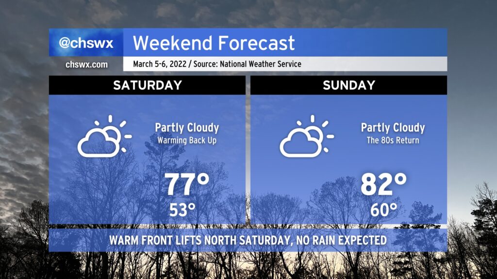
After a brief interlude on Friday thanks to a cool wedge of high pressure building into the area, warmth and sunshine returns Saturday as the front lifts back northward as a warm front. Like the cold frontal passage last night, we’ll remain rain-free as the warm front lifts northward.
With the wedge airmass out of here, temperatures jump back to the mid-to-upper 70s by Saturday afternoon, and we’ll warm even further toward the low 80s on Sunday. The record high for March 6 is 85°, and we might get within spitting distance depending on how much heating can develop.
Warm weather will continue into Monday with near-record highs possible again. Beyond that, things take a turn for the unsettled for much of the next work week with temperatures running a little cooler (but still above normal).
We set a record high today at downtown Charleston: 80° broke the record of 79° set in 1976. We’ll get a brief interlude in the warmth Friday as high pressure wedges southward across the area, turning winds more northeasterly and kicking up the cloud cover to keep temperatures running about 15-20° cooler than we saw today. Moisture is scant, though, so no rain is expected — we’ll just be chilled out briefly before the wedge front lifts northward on Saturday, returning us to the 70s and 80s for the weekend. We remain rain-free through Tuesday before the pattern turns more unsettled as we get deeper into the next work week.
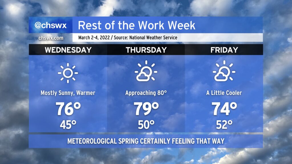
After topping out around 70° today, temperatures will aim ever warmer for Wednesday and Thursday before a dry cold front knocks temperatures down a bit for Friday. Mostly sunny skies will be the rule throughout, and with winds more out of the west, the risk for coastal flooding will decrease, too. Weather looks to get even warmer as we get into the weekend, too, with rain chances maybe returning to the forecast next Tuesday.
We’re getting close to the last freeze dates of the season (the median last freeze at North Charleston is March 8), but we can still have bouts of freezing temperatures well into early April, so be cautious if you begin planting. To that end, though, the National Weather Service has restarted the frost and freeze program as of today, which means Frost Advisories and Freeze Warnings will once again be issued by the NWS office when conditions become questionable for vegetation. If those end up being needed at any point, I’ll pass them on.