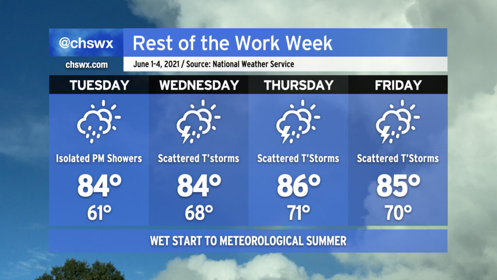
We’ll have more chances for beneficial rainfall tomorrow across the Lowcountry as scattered showers and even a few thunderstorms will be possible for much of the day. Onshore flow and storms in the area will keep high temperatures down into the low 80s. No severe weather is expected, just more much-needed rain. Not everyone will see rain, and it won’t rain all the time. If you miss out tomorrow, rain chances continue to head up as we get into Thursday and Friday, so chances are good you’ll see something as the pattern turns wetter across the area.
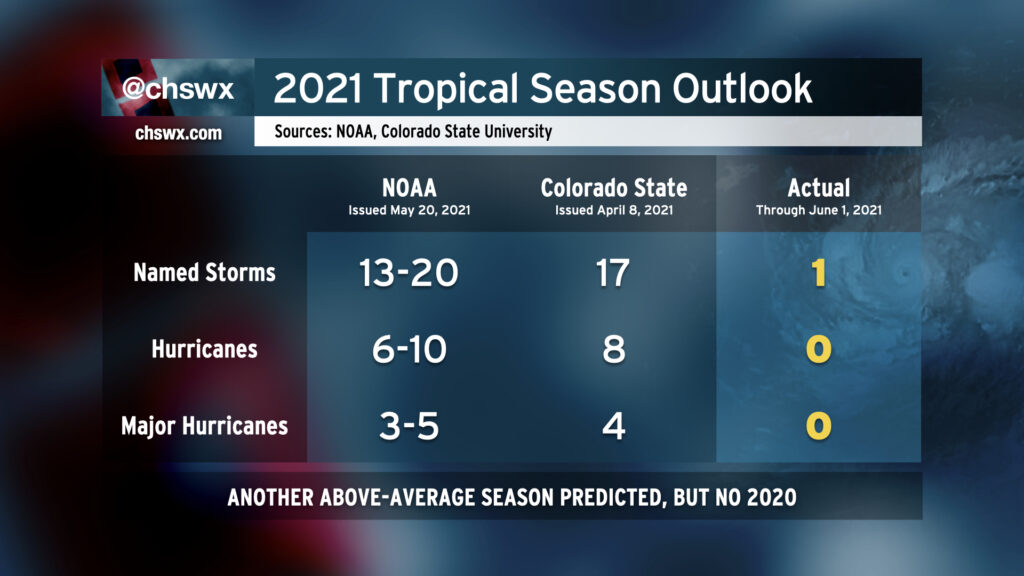
Well, friends, it’s that time of year again: The Atlantic hurricane season begins today and runs through November 30. Seasonal forecasters from Colorado State University and NOAA are calling for another above-average season when considering continued warm sea surface temperatures and ENSO-neutral conditions (read: no La Niña nor El Niño is expected). While a repeat of the sheer volume of the 2020 hurricane season is unlikely, it still looks to be busy out there.
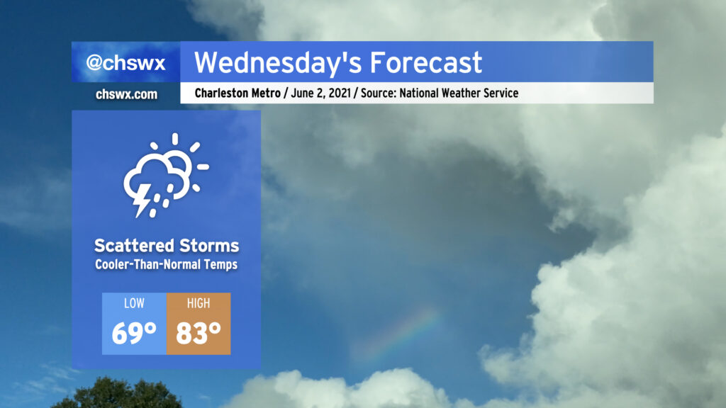
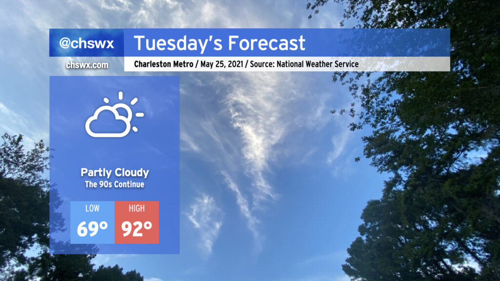
We’ll get June off to an increasingly rainy start as the dry high pressure which brought us two incredible days this weekend begins to break down. Expect to get much of Tuesday in rain-free, but a few showers will be possible in the afternoon and evening hours as a coastal trough begins to sharpen nearby and moisture begins to peek ashore. As we get into Wednesday, more moisture will overspread the area and shower and storm coverage will kick up a little bit. We’ll see this pattern persist into Thursday and Friday, with afternoon showers and storms becoming more likely each day, bringing some more much-needed rainfall to the area. If you didn’t get much with Saturday evening’s activity, you’ll more likely than not have some measurable rainfall by the end of the week.
High temperatures will remain at or ever-so-slightly below normal through the work week thanks to onshore flow and expected afternoon showers and thunderstorms. Lows will be creeping back toward 70° with the increasingly humid airmass in place. With June 1 marking the beginning of meteorological summer, it will be as if the humidity will be right on cue.
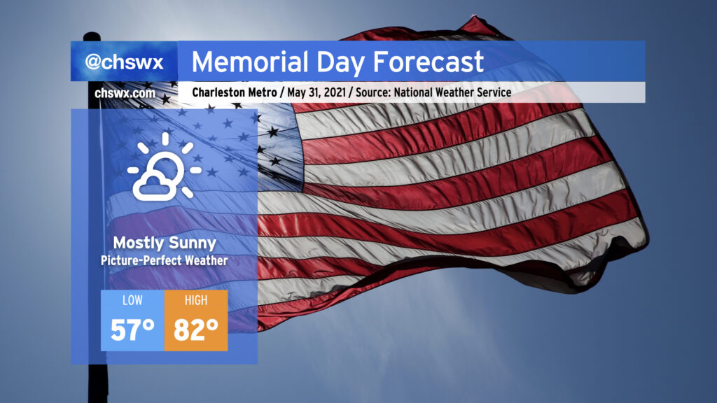
We will commemorate Memorial Day and close out May with picture-perfect weather. Lows will run 5-10° below normal away from the immediate coast, warming nicely into the low 80s under mostly sunny skies as high pressure remains in control over the Southeast. Onshore flow will keep temperatures cooler closer to the coast, with upper 70s likely as high as we get there. Humidity will be comfortable with dewpoints in the mid-50s, too. As we know, this is increasingly rare air for this time of year, so be sure to take advantage as the rest of the work week turns a little warmer and increasingly unsettled.
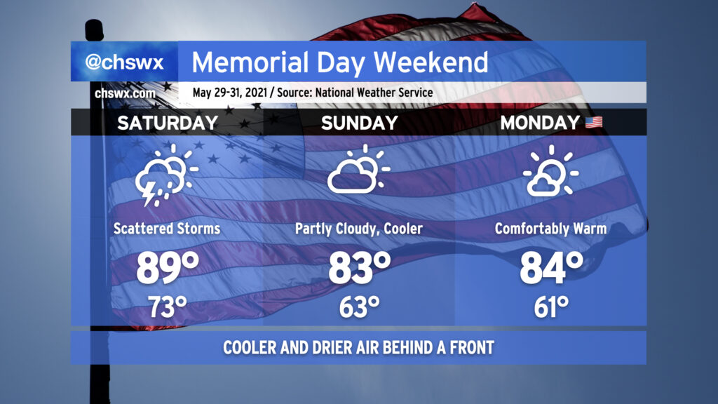
We’ll get off to a warm, humid, and perhaps a stormy start to the Memorial Day weekend, but a late-season cold front will make the weather very pleasant for Sunday and Monday.
A cold front, which as of publish time was draped over the Mid-South from Kentucky southward through Tennessee and far northwest Mississippi, will be advancing eastward toward the coast on Saturday. Atmospheric moisture will surge ahead of the front, providing a more hospitable atmosphere for afternoon showers and thunderstorms than we have seen in the past week or so. Temperatures will top out around 90° before scattered storms kick in ahead of the front. Brief downpours will be possible, but no severe weather is expected. (In fact, not everyone may even get rain.)
The front will get through overnight Saturday into early Sunday morning, ushering in a cooler and drier airmass. We’ll start Sunday about 10° cooler than we started Saturday, with lows in the low 60s away from the locally warmer coast. Highs will top out in the low 80s, a little below normal for late May, and will feel pretty great after a week of 90s. This comfortable warmth continues into Monday with a little bit more blue sky to boot. Overall, not too bad — we need the rain, and it’s awfully nice to enter June in the mid-80s rather than the upper 90s!
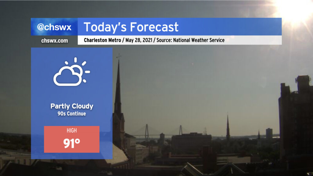
We’ll be back in the 90s today — perhaps for the last day for a little while — as the lingering effects of high pressure aloft remain for one more day before a front moves into the area on Saturday. Unlike yesterday, an earlier seabreeze progression will keep highs capped around 90-91°. (Yesterday’s high was 94°, tying Monday for warmest so far in 2021.) A shower or two can’t be totally ruled out as the seabreeze progresses inland, but with dry air remaining in place for one more day, coverage will be limited.
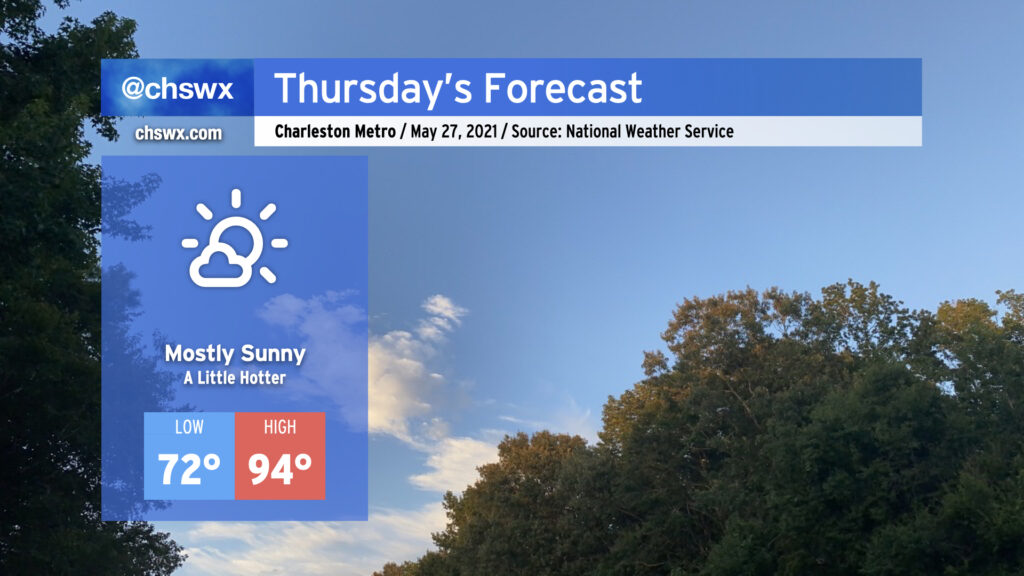
We’ll see a little more sunshine tomorrow, and that’ll add a little more heat to the forecast as a result. Temperatures will top out in the mid-90s away from the immediate coast on Thursday with winds out of the southwest turning more southerly as the seabreeze moves inland later in the day. A popup shower or two ahead of the seabreeze cannot be discounted, but the vast, vast majority of us continue our rain-free streak. We’ll see more shower and storm chances come into the picture over the weekend — hang in there, lawns and gardens.
High pressure will continue to slip a little more to the east today, allowing the resulting return flow to bring a little bit more humid air characterized by dewpoints in the mid-60s into the area. Once again, we look to remain mostly rain-free across the area; the best chance of a shower or two will be in northern sections of Berkeley and Dorchester counties near I-95 closer to a trough of low pressure. Otherwise, expect a mix of high clouds and fair-weather cumulus as temperatures rise into the low-to-mid-90s ahead of the seabreeze. Heat indices will be a couple ticks higher today, generally in the mid-90s in the afternoon, particularly right after the seabreeze and its associated dewpoint surge pass by.
Temperatures and humidity will continue to creep up for the next couple days before a cold front knocks down temperatures — and brings some isolated to scattered storms — for the Memorial Day weekend.
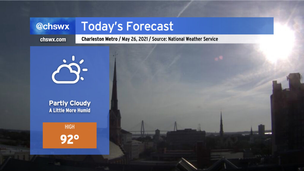
After topping out at 94° today to mark the hottest day of 2021 so far, we return to the 90s tomorrow as the stacked high pressure pattern remains in place. If you’re looking for rain, you’re not going to find it with the ridge keeping a lid on any deep convection. Humidity remains tolerable, so heat indices will not get too far out of bounds (though there may be a brief spike as the seabreeze pushes inland). That being said, low-to-mid-90s are still plenty toasty, so find shade when you can if you’re outdoors.
We stay in the 90s for the rest of the week, with temperatures turning hotter as we get into Thursday and Friday. Humidity will also be creeping up as high pressure slides offshore, bringing winds out of the southwest and pumping in 70°+ dewpoint air. Our next rain chances kick in over the weekend as a front gets close to the area.