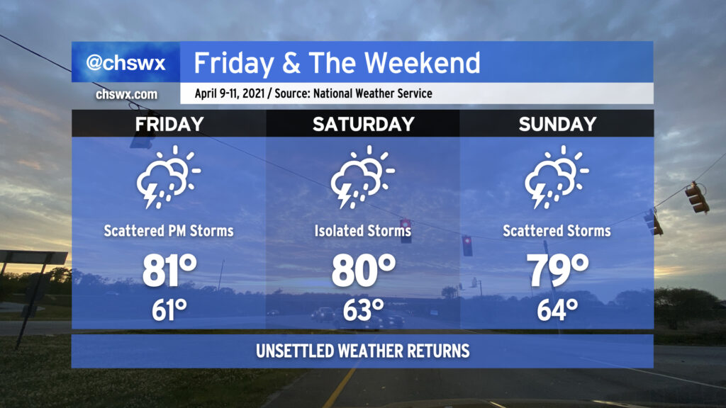
Well, as they say, all good things must come to an end, and our stretch of great weather is no exception. We’ll begin to see scattered storm chances enter the weather picture later in the afternoon on Friday and stick around into the weekend as a more moisture-laden airmass takes residence. Temperatures will remain fairly warm each day, with 60s in the morning and highs within a couple degrees either way of 80° in the afternoons.
The good news on the rain chances this weekend is that it doesn’t look like we have a total weekend washout in store. Rain chances will be transient and largely driven day-to-day. My best advice is to plan out your weekend as is, and just ensure that you have indoor activities as a backup. I’d pencil in Saturday as probably the less active of the two weekend days, with decent model agreement that a cold front will be driving through the area Sunday, but we’ll want to take this day by day as things evolve upstream.
So far, it doesn’t look like we’ll have any severe weather concerns this weekend, but be reminded that all thunderstorms are dangerous because of lightning.
All in all, this weekend will be good practice for planning outdoor activities during the summer months! Stay dry and safe and do your best to enjoy!
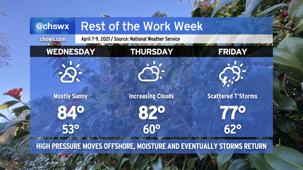
We continue our weather winning streak on Wednesday as temperatures rise into the mid-80s once again under mostly sunny skies. Humidity will remain on the low side as one more day of dry air persists. As we get into Thursday, though, high pressure will be headed offshore, and the resulting moisture return will allow for cloud cover to thicken back up and humidity to increase a little bit more. By Friday, we’ll have enough moisture in place ahead of a stalling cold front to allow for some showers and thunderstorms in the afternoon, with scattered storms remaining in the forecast through the weekend (depending on the progress of the front).
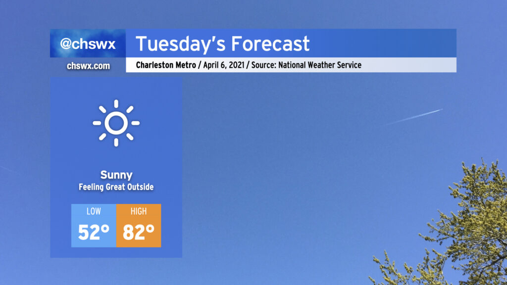
There’s really not much to say about tomorrow other than it’s going to feel pretty good outside with high pressure at the surface and ridging continuing to build aloft, putting the kibosh on any cloud that even thinks about getting going. Highs in the 80s with low humidity and full sunshine will make you wish it wasn’t Tuesday. This great stretch of weather continues Wednesday with a few more clouds. Thursday looks dry, but clouds will thicken back up as the day goes on ahead of our next storm system, which brings shower and storm chances into the area for Friday. But for now, soak it in as you can! Before you know it, we’ll have six months of humidity.
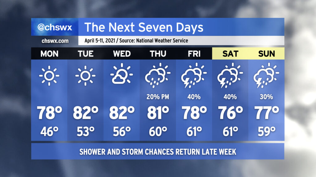
After quite a cold snap closed out last week, temperatures will be back at or a little above normal as we get into the first full week of April. There will be plenty of sunshine in the offing particularly Monday through Wednesday as high pressure maintains firm control over our weather. Lows will start out in the upper 40s on Monday but will warm into the mid-50s by Wednesday morning. Highs will generally run in the upper 70s to low 80s.
Changes begin to show up in the form of at least a few more clouds for Thursday as a storm system starts shoving the surface high offshore, allowing for some more moisture return. There’s an outside shot at a few showers Thursday evening, but the better rain chances will be ahead of the storm system’s cold front on Friday. We could see a few thunderstorms in the mix as well. The front will get through Saturday, but lingering moisture keeps rain chances in the forecast for most of the weekend. It doesn’t look like a washout, though, and as always, we’ll have time to fine-tune the details throughout the week. For now, enjoy the warm sun!
After very likely setting a new record low maximum temperature today with a high so far of just 53°, our cold snap continues into tonight and tomorrow. A Freeze Warning is in effect for the Tri-County tonight as temperatures are expected to dip below freezing for at least a little while particularly inland and in sheltered areas. The record low of 33° at the airport, set in 1962, certainly seems in jeopardy to fall. Even where temperatures don’t drop below freezing, there is some potential for frost. Wherever you are, protect plants and pets tonight!
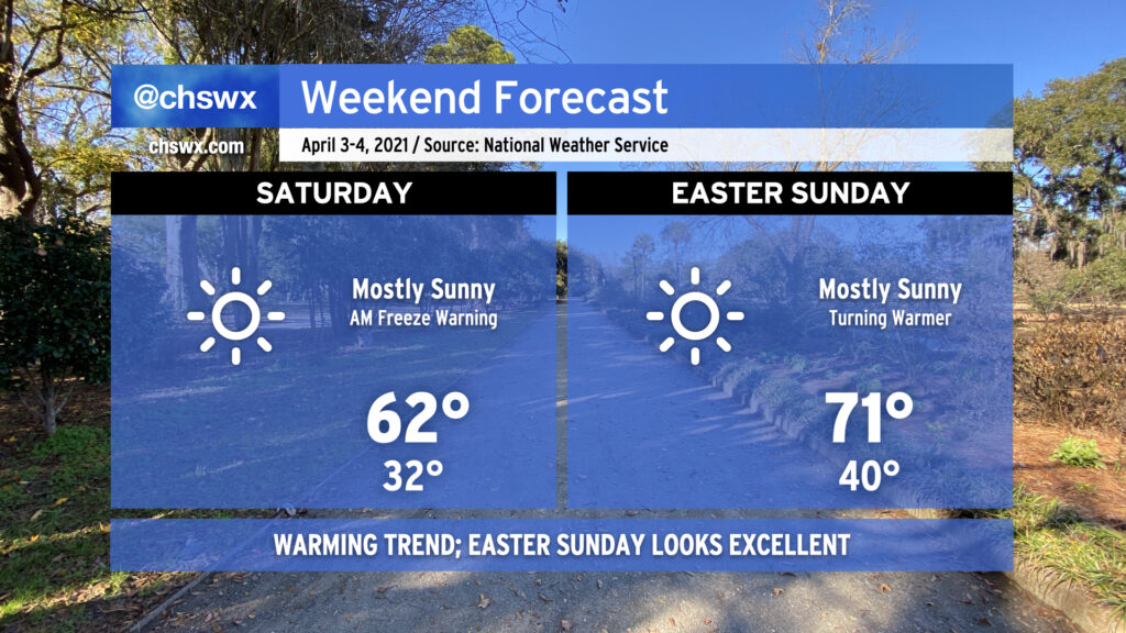
Saturday afternoon should see high temperatures run about 9-10° warmer as the trough that brought us this cold snap moves well away from the area and the April sun angle is able to modify the airmass. We’ll keep high pressure firmly in place at the surface, and that should yield an exceptionally nice spring day with highs in the low 70s in the afternoon.
Beyond the weekend, temperatures will gradually warm to the low 80s by the middle of next week. We’ve got a pretty decent dry stretch ahead of us before our next storm risk arrives for next weekend. Enjoy, and stay warm!
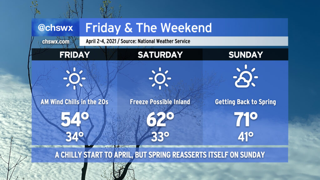
Get ready for what is probably Winter’s final hurrah starting tonight into this weekend. Overnight tonight, temperatures look to fall to the mid-30s in the Charleston Metro Area, with the potential for those temperatures to fall even a bit more inland. I’d protect plants and pets tonight to be on the safe side. Wind chills tomorrow morning will run as low as the mid-20s at times — bone-chilling for January, somewhat absurd for April. In addition to possibly setting a record low in the morning (the record is 36° set in 1942), Friday’s forecast high of 54° would break the record low maximum temperature of 56° set in 2019. All this and we will have full, unfettered sunshine throughout the day. Quite a potently cold airmass, for sure.
The chill continues into Saturday morning. Winds look to back off a little bit, but that may just allow for better radiational cooling conditions with the potential for a freeze inland from the coast and patchy frost elsewhere. Friday night into Saturday morning will be another time to protect your plants and pets from the chilly conditions. Saturday afternoon does look a little warmer with highs getting into the low 60s, but this is still well below normal for early April.
By Sunday, though, we begin to lift out of the cold snap with lows in the low 40s in the morning, followed by highs getting back into the 70s in the afternoon. Just a few clouds will be around, and it looks to be a rather pleasant day.
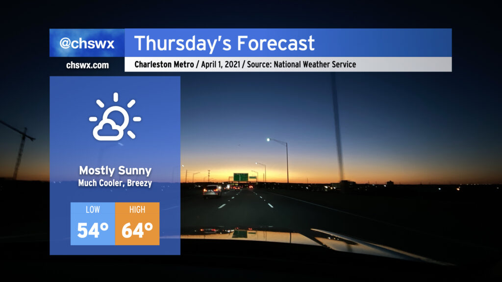
It was a busy weather evening, with numerous reports of hail inland from the coast, a lot of lightning, and a lot of heavy rain. The storms will give way to a cold front swinging through overnight, and by Thursday morning, we will begin to see quite a cooldown. We’ll go from a high of 82° on Wednesday to highs struggling into the mid-60s for Thursday. (No fooling.) It’ll be breezy in the wake of the front, too. However, the sun will be out, and the early April sun angle will feel pretty good when balanced with the cooler air temperatures.
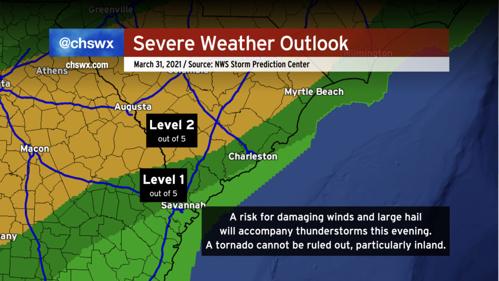
We’ll have a risk of some strong to severe thunderstorms later this afternoon into this evening as a sharp cold front swings through the area. We’ve had plenty of sunshine thus far, and that is certainly helping the atmosphere destabilize ahead of said front. Damaging wind gusts are the primary concern, but a tornado cannot be ruled out somewhere on the leading edge of the line as well. The greatest risk of severe weather generally lies along and west of 17-A as daytime heating and marine influences stabilize things closer to the coast, but severe storms will be possible pretty much anywhere in the Tri-County this evening; NWS is thinking between 6PM and midnight for our neck of the woods.
Stay close to reliable weather sources this afternoon and be ready to take action in case warnings are issued.