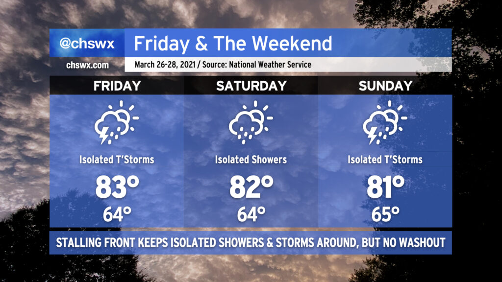
This weekend is going to have quite a summer-like feel to it with highs in the 80s and a slight chance of showers and storms each afternoon.
A cold front will be weakening and stalling out across the area Friday into Saturday. The front, a remnant of the strong storm system that is responsible for a severe weather outbreak in the mid-South today, will not be able to overcome the ridging aloft and strong surface high pressure. However, a few storms will be possible on Friday with the potential for one or two of them to produce damaging wind gusts and large hail. Widespread severe weather is not anticipated, though.
Getting into Saturday, we see the stalled front still in the area, perhaps acting as a focal point to kick off a few showers or storms. Otherwise, the story will be the warmth — lows in the mid-60s will continue to flirt with record high minimums, and highs in the low to mid-80s appear common, with potentially higher temperatures inland.
Another cold front will backdoor into the area from the north on Sunday. A few showers and thunderstorms will once again be possible ahead of said front, and a couple of those might err on the strong side, but once again widespread severe weather does not appear to be in the cards. This front will actually make it through the area, though, and by Monday, temperatures will be 10-15° cooler as high pressure wedges in from the northeast.
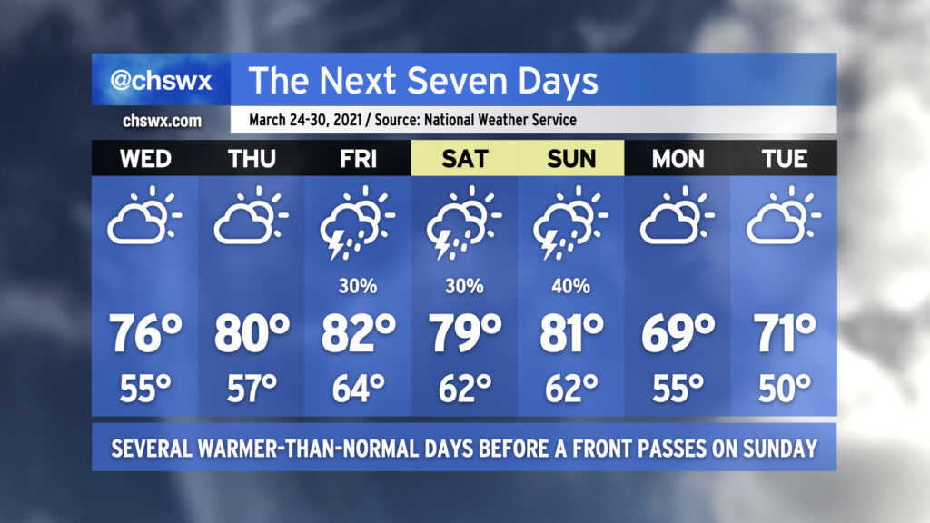
After temperatures overachieved today, we look to continue remaining a little warmer than normal as we go into Wednesday. Ridging aloft will continue to build over the next couple days, and by the end of the week we should be getting into the 80s ahead of a cold front that swings through Sunday. We look to remain rain-free through Friday, when a weakening cold front gets into the Carolinas and eventually stalls out and falls apart. While a strong storm or two can’t be ruled out, widespread severe weather is not anticipated.
As mentioned earlier, another, stronger cold front will swing through Sunday with a few thunderstorms, taking us back to closer to normal temperatures for Monday and beyond.
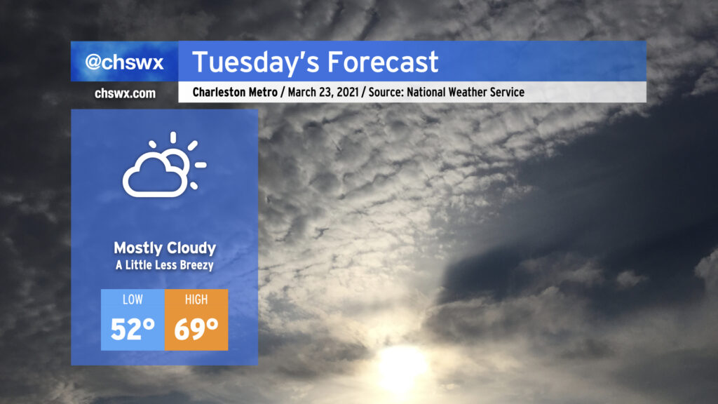
Cloud cover will look to be a bit more persistent on Tuesday, once again keeping temperatures right around 70° in the afternoon with low pressure stuck offshore, roughly about where the NC and SC border would be. Conditions should remain rain-free throughout the day, and we should get the sun peeking in and out as well.
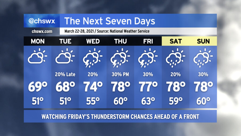
We’ll be warming up as the week goes on — the last full week of March, already! — with isolated to scattered showers and storms possible beginning Tuesday night. The next significant storm system on the docket is expected to arrive sometime Thursday or Friday, but persistent low pressure keeps rain chances in the picture well before that.
Gusty winds will continue overnight into Monday, with 30-40 MPH gusts possible near the coast and on bridges. This is due to a tight pressure gradient between a wedge of high pressure inland and a surface low migrating northeastward off the coast. Northeast winds look to relax a little on Tuesday, but could still be gusty at times near the coast. A High Surf Advisory and a High Risk of Rip Currents is in effect for Monday — not a great beach day, for sure.
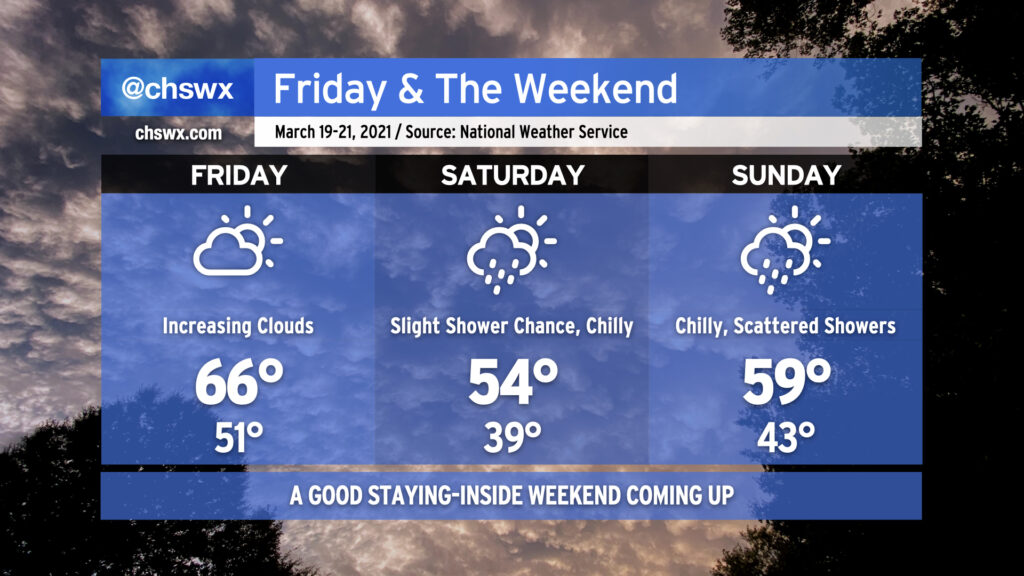
We’ll get Friday off to a nice start in the wake of the cold front which instigated a lot of the rough weather over the last couple days in the eastern half of the country. Temperatures will start around 50-51° under mostly clear skies. We’ll warm to the mid-60s before another cold front “backdoors” in from the north, bringing much cooler temperatures and a return to cloud cover.
Yes, folks…the wedge is back.
Saturday will start out much cooler than normal, with highs in the upper 30s. Temperatures will only head up to the mid-50s as the wedge settles in. At the same time, a low will spin up off the Florida and Georgia coast. Convergence on the northern half of the low could help spread a few showers into the area as early as Saturday, but slightly better rain chances arrive on Sunday as the low heads northeast, coming a little bit closer to our coastline. Sunday looks a bit warmer with highs near 60° as the wedge seems to weaken a little bit. Don’t fret — we’re back in the 70s by next Tuesday.
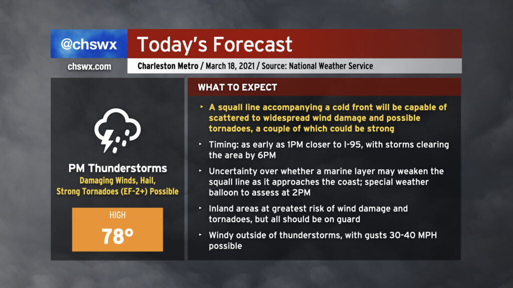
Today could feature a severe weather episode across the Lowcountry in the afternoon and early evening hours as a squall line pushes through the area. Damaging straight-line wind gusts are the primary concern, but embedded strong tornadoes and some large hail will be possible as well. We may see some weakening of the storms as they approach the Charleston metro area as the line interacts with a more stable marine layer, but I wouldn’t hang my hat on it as these storms could remain vigorous enough to overcome the stable air.
Before the storms arrive, expect mostly cloudy skies with some peeks of sun. Highs should top out in the upper 70s provided the line does not sweep through earlier than anticipated. It’ll turn windy outside of thunderstorms as the low-level jet kicks up throughout the day. Gusts to 30+ MPH will be possible, making bridge driving a little more tricky.
Storms should clear the area by around 6-7 PM if current timings hold, and we will turn much cooler tomorrow.
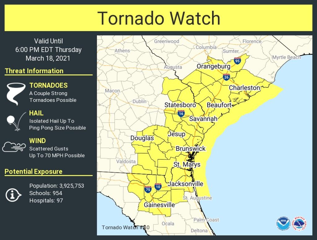
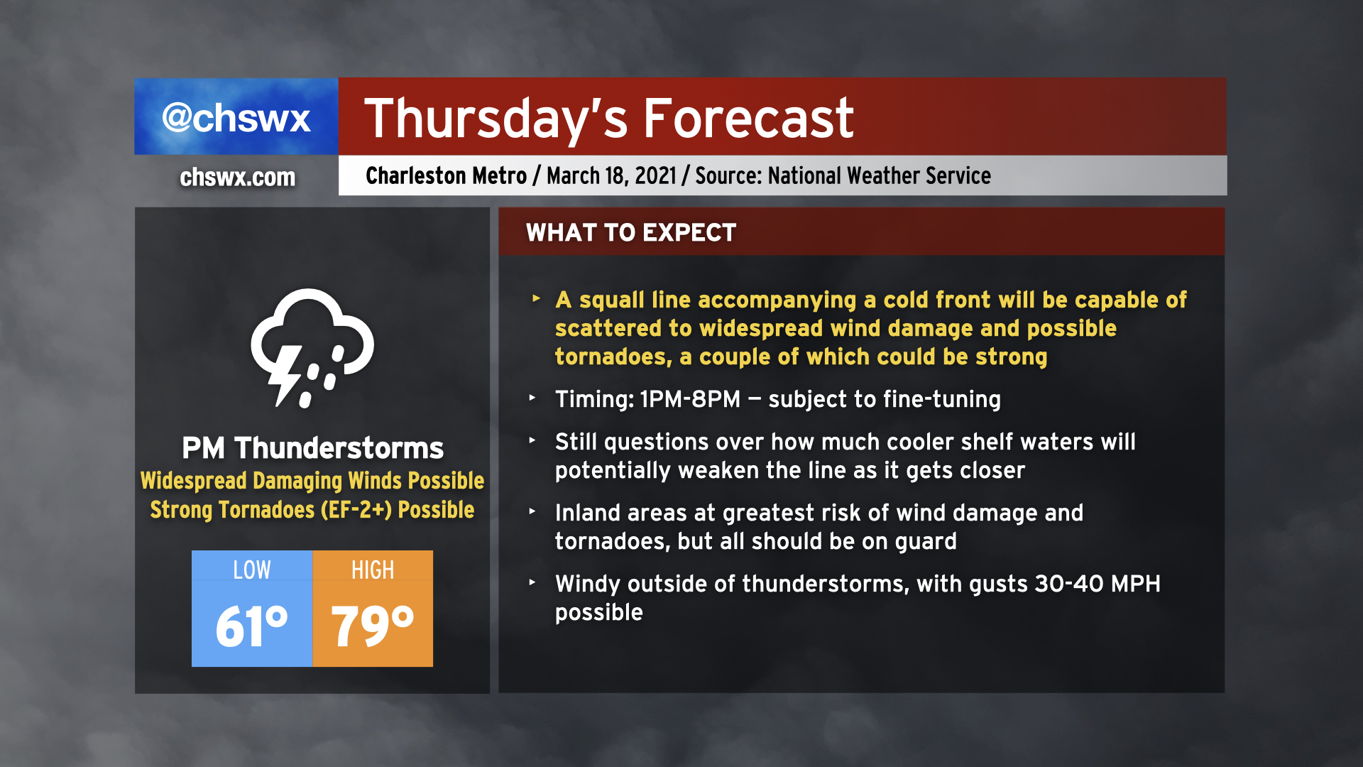
Severe weather appears to be in the cards for Thursday as a cold front approaches the area in the afternoon and early evening hours. This cold front is expected to be bringing a squall line with it, and the atmosphere ahead of the line will become increasingly favorable for sustaining severe weather. Temperatures will surge to near 80° especially away from the immediate coast before being tamped down later in the day. Even outside of thunderstorms, it will be windy, with gusts 30-40 MPH possible thanks to a strengthening low-level jet, which will help contribute to increased shear to help organize severe thunderstorms.
The squall line is the main concern, though. The line could enter western portions of the Tri-County as early as 1-2 PM, and may exit as late as 8 PM, based on the National Weather Service’s latest timing estimates. The line is slowly starting to take shape across Louisiana, and we will want to watch its progress closely over the next 24 hours to ensure timing and forecast is on track. A somewhat later arrival could mean more time for the atmosphere to destabilize, increasing the severe weather threat.
Hazards with the line include the risk for widespread damaging straight-line winds as well as a few tornadoes — a couple of which could be on the strong side, particularly near the I-95 corridor. Quarter-size hail is a possibility as well. Additionally, while not explicitly modeled in our area, we’ll want to keep an eye on any storms that might try to get going ahead of the line as those could pose a higher tornado risk.
Finally, it’s most important to note that not all of you will see severe weather tomorrow. There are limiting factors at play, including the role that the cooler Atlantic shelf waters may play in stabilizing the atmosphere closer to the coast and just how unstable the atmosphere can ultimately get here due to cloud cover. Severe weather forecasts are rarely a slam dunk in the Lowcountry because of our unique geography. With all that said, though, let’s be ready for the worst, but hopeful for a relatively quiet day.